- The paper presents a method that injects metric scale into feed-forward 3D reconstruction models using satellite imagery, effectively resolving inherent scale ambiguity.
- The approach uses cross-view neural attention to fuse coarse GPS-localized ground views with satellite patches, enabling accurate metric depth, camera pose, and point cloud reconstruction.
- Experimental evaluations on KITTI and nuScenes demonstrate state-of-the-art performance in depth estimation, point cloud accuracy, and precise geo-localization.
Empowering Feed-Forward 3D Reconstruction Models with Metric Scale via Satellite Images
Introduction
Classic feed-forward 3D reconstruction models achieve strong geometric generalization but are limited by the inherent scale ambiguity of monocular and multi-view visual input—namely, reconstructed geometry and camera motion are only recovered up to a global scale factor. This constraint reduces the utility of foundation 3D models in applications such as autonomous navigation or robotics, where knowledge of metric distances is required. Existing remedies involve metric-annotated datasets or precise camera calibration/SfM, both of which are unreliable or impractical in large-scale, diverse, or unconstrained environments.
This work proposes a general framework to inject metric scale and global spatial referencing into foundation-model-based 3D reconstructions by leveraging widely available satellite imagery. The approach retrieves a local satellite patch as a global metric reference, given a coarse GPS-localized ground view, and fuses satellite-ground observations via cross-view neural interaction. The result is a feed-forward architecture that recovers metric scene geometry together with absolute (metric) camera pose estimates (Figure 1). This enables both metric 3D reconstruction and precise geo-localization for downstream applications.
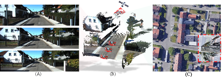
Figure 1: By incorporating satellite patches retrieved from coarse GPS signals, the method resolves scale ambiguity and achieves metric scene reconstruction with absolute camera pose estimation; projection accuracy onto the satellite image is visually confirmed.
Methodology
The framework targets the ill-posedness of scale in feed-forward geometric models by conditioning estimation on both ground-view and registered satellite observations. Satellite imagery, intrinsically georeferenced and encoding terrain at a metric scale, provides the external cues needed to resolve scale ambiguity.
The process begins by retrieving a satellite patch using coarse GPS data, relaxing the need for highly accurate initial pose. Given this patch and the ground image(s), the model—built atop a frozen geometric foundation (e.g., π3)—applies bidirectional cross-view attention between learned ground and satellite features. This interaction computes three crucial corrections:
- A global scale factor β, mapping relative geometry to metric units;
- A coordinate offset C (rotation/translation) aligning reconstruction into the satellite's coordinate frame;
- A point-wise geometric correction ΔXN to accommodate fine-grained residual misalignments.
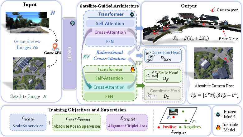
Figure 2: The architecture combines a satellite patch (retrieved using coarse ground-view pose) and ground-view imagery, estimating global scale, offset, and geometric refinement for metric reconstruction and localization.
Supervision involves:
- Direct losses on the scale factor to minimize divergence from ground-truth metric geometry.
- Pose losses on translation and rotation in the satellite frame.
- Alignment consistency (triplet or contrastive) losses encouraging BEV-projected features from the reconstructed scene to correspond to satellite features at the correct location, implemented via differentiable projections and DINO feature encodings.
The entire framework is agnostic to the underlying geometric backbone, and training employs staged optimization: global alignment is first achieved through the learned scale and offset, followed by geometric refinement.
Experimental Results
Metric Depth Estimation
Evaluations span monocular and multi-view scenarios on KITTI and nuScenes, with all cross-dataset generalization results obtained by training on one dataset (e.g., nuScenes) and testing on another (e.g., KITTI), providing an uncompromising benchmark for generalization.
The method achieves the strongest reported performance across multiple error metrics (AbsRel, SqRel, RMSE, δ1, δ2, δ3) in monocular metric depth estimation, outperforming even foundation-level baselines like DepthAnythingV3 and MoGeV2 by wide margins. Importantly, when compared to both scale-agnostic and metric-trained baselines, it shows significantly reduced error in the demanding metric prediction setting, not just after scale alignment.
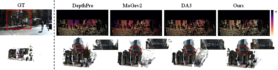
Figure 3: Visualization of monocular metric depth shows highly accurate scale recovery and fine geometric detail with minimal depth error compared to ground truth.
Multi-View Point Cloud Estimation
Quantitative and qualitative results for multi-view point-cloud estimation (Acc., Comp., Normal Consistency) underline substantial improvements in output completeness and noise reduction.
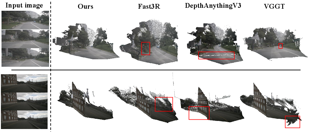
Figure 4: Multi-view point clouds from the proposed method are denser and less noisy, exhibiting higher accuracy and completeness than prior approaches.
On nuScenes, when compared against models aligned by ground-truth scale, the proposed system yields the lowest reconstruction error and highest normal consistency. In true metric prediction (without post-hoc alignment), its advantage over other metric approaches is even more pronounced.
Metric Pose Estimation
Metric camera pose localization is evaluated on challenging cross-view datasets (Cross-View KITTI, Oxford RobotCar). Localization error (mean/median) is compared in both “same area” and “cross area” splits, further stressing generalization.
The proposed method sets new state-of-the-art error rates for both positional and orientation estimation, generalizing robustly to unseen regions and temporal variation.
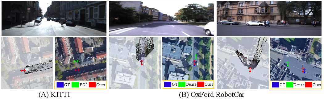
Figure 5: Cross-view localization visualizations demonstrate alignment between reconstructed scenes and underlying satellite reference frames, supporting high-precision camera pose estimation.
Ablation Studies
Ablation analyses demonstrate that both the satellite reference and geometric correction modules are necessary for achieving state-of-the-art metric prediction and generalization. Removing either degrades accuracy, completeness, and structural consistency.
Implications and Future Directions
This work demonstrates that satellite imagery is an effective, scalable, and cost-efficient global reference for metric 3D reconstruction in uncalibrated or weakly calibrated settings. By fully resolving scale ambiguity, the framework makes powerful foundation geometric models directly usable in metric-dependent downstream tasks—such as robotics, navigation, vehicle localization, and augmented reality—without relying on extensive metric annotation or high-precision sensors.
Theoretically, bridging ground and satellite modalities through cross-view neural alignment moves the field closer to universal, generalizable scene understanding. Practically, it provides a path toward robust, global metric localization for embodied agents under realistic constraints.
Future developments may include leveraging richer geosource data—building footprints, semantic maps, high-resolution aerial LIDAR—or closing the loop with other global signals (e.g., wireless or SLAM-based priors). Generalization to indoor-outdoor domain fusion and integration with temporal or multi-modal cues represents promising directions for AI-based scene understanding.
Conclusion
The presented framework systematically eliminates the scale ambiguity in contemporary feed-forward 3D reconstruction by synergizing learned geometry with the globally-referenced metric cues present in satellite imagery. The resulting models exhibit strong metric prediction and localization performance while retaining the desirable generalization and efficiency of foundation geometric models. This enables practical deployment for a range of AI applications historically constrained by visual scale ambiguity (2606.08205).