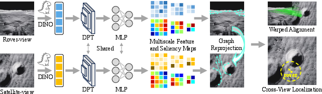
- The paper presents a novel WARG framework that achieves pixel-level, drift-free localization without reliance on GNSS.
- It combines deep semantic feature extraction with graph construction and alignment to robustly match rover and satellite views.
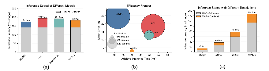
- WARG outperforms previous methods on simulated and real lunar datasets, significantly reducing localization error and improving inference speed.
Graph-Based Cross-View Pixel-Level Localization for Lunar Rovers
Introduction
Accurate localization remains a critical challenge for robotic exploration on the lunar surface due to the lack of GNSS infrastructure and the limitations of traditional, locally-referenced techniques such as inertial odometry and visual dead-reckoning. "Globally Localizing Lunar Rover in Pixels via Graph Alignment" (2606.10602) presents Warped Alignment of Reprojected Graphs (WARG), a unified graph-based cross-view localization method capable of delivering high-precision, drift-free global positioning using only rover-view and satellite-view imagery without dependence on prior pose estimation or motion histories.
The unique contributions of this work address fundamental issues in planetary-scale visual localization, including the perceptual aliasing of repetitive lunar terrain, severe cross-view domain gaps (illumination, scale, occlusion), and the sim-to-real transfer that limits most deep learning approaches on planetary data. The authors present WARG as a generalizable, computationally efficient solution that attains pixel-level precision and remarkable robustness across both simulated and real lunar datasets.
Challenges in Lunar Rover Localization
Traditional localization on Earth leverages globally-referenced navigation systems, but lunar environments are GNSS-denied, requiring alternative strategies. Local methods, including inertial navigation, wheel odometry, and stereo-based point-cloud registration, suffer from cumulative drift and fail to generalize over long traverses and unstructured terrain.
The lunar surface further complicates global localization:
- Inter-entity entanglement: Distinct lunar entities (e.g., craters and rocks kilometers apart) can be visually identical, leading to aliasing in feature matching and failure of instance-level discriminative approaches.
- Intra-entity divergence: A single entity may have drastically different appearance under varying illumination, scale, and viewpoint, inhibiting cross-view feature invariance.
- Sim-to-real gap: Models trained on synthetic data struggle to generalize to real lunar imagery, exacerbated by domain shifts in surface texture, lighting, and sensor noise.
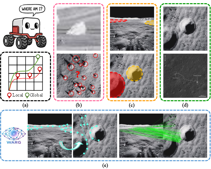
Figure 1: Overview of lunar localization challenges—entity ambiguity, viewpoint divergence, simulation-to-real domain gaps, and the WARG solution.
WARG Framework: Methodological Advances
WARG overcomes these challenges by combining deep semantic feature extraction with graph-based geometric reasoning and a symmetric, weight-sharing architecture:
Quantitative Benchmarking and Robustness
WARG is comprehensively benchmarked on three datasets:
- LuSNAR (simulation): Standard lunar terrain with high-fidelity, ground-truth labels.
- South (simulation, domain generalization): Simulated south polar lunar region with extreme illumination.
- YuTu-2 (real): Orbital and rover imagery captured during the Chinese YuTu-2 lunar mission.
Across all datasets, WARG yields substantial improvements over prior SOTA approaches:
| Dataset |
Prev. SOTA Error (m) |
WARG Error (m) |
Relative Improvement |
| LuSNAR |
20.89 |
0.32 |
∼65x |
| South (zero-shot) |
33.09 |
3.63 |
∼9x |
| YuTu-2 (real) |
12.89 |
1.68 |
∼7x |
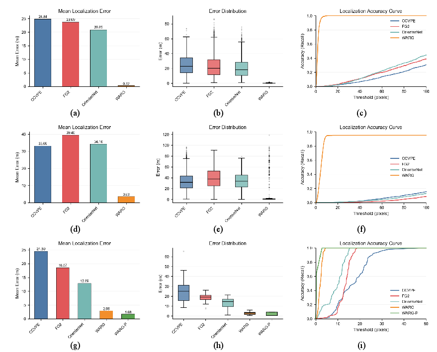
Figure 3: Localization accuracy and error distributions for LuSNAR, South, and YuTu-2 datasets.
A thorough robustness study validates resiliency under severe occlusion, simulated motion blur, and variable search region sizes, with WARG maintaining accurate predictions regardless of such adversarial conditions.
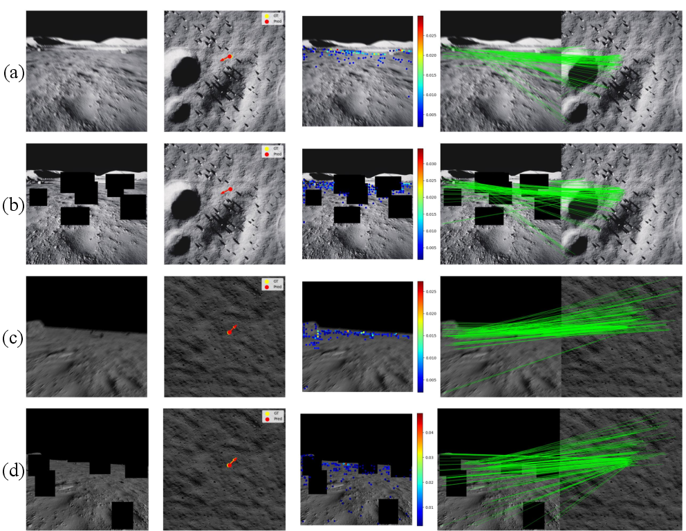
Figure 5: Robustness to strong motion blur and feature occlusion during localization on both benchmark datasets.
Resolution of Entanglement and Divergence
Structural Reasoning via Graph Alignment
Instance-based matching under repetitive lunar terrain is shown to be ill-posed. WARG's graph-based approach leverages the unique constellation and relative geometry of collectively salient entities, decisively eliminating inter-entity entanglement as more spatial context is aggregated.
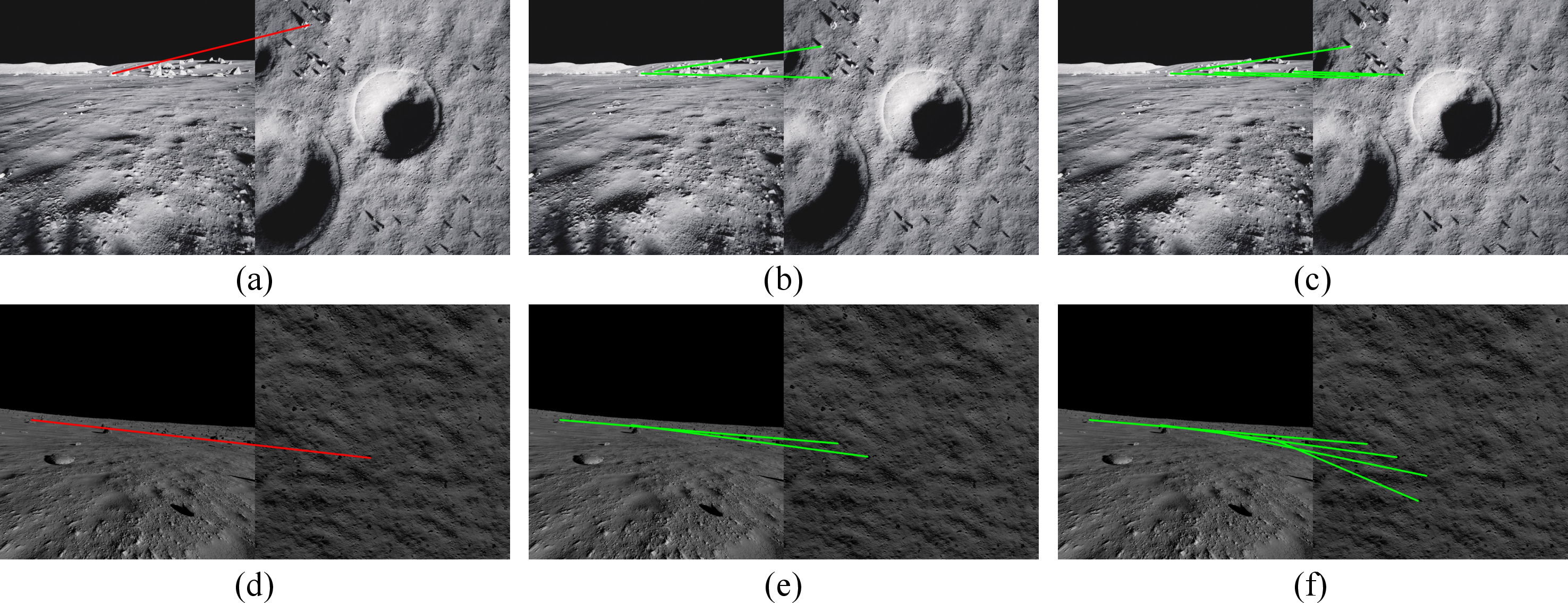
Figure 6: The resolving power of multi-entity constellations in structural graph matching.
Joint analysis of appearance and structure—using dense similarity heatmaps before and after graph constraint application—demonstrates conversion of ambiguous, multi-modal activations to single, sharp discriminative peaks post-structural reasoning.
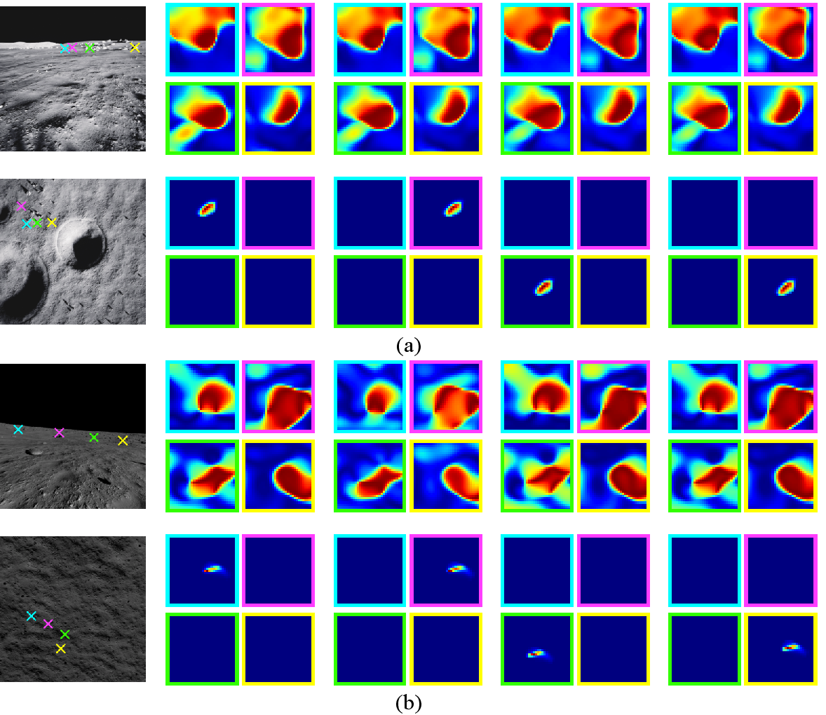
Figure 7: Elimination of ambiguous matching via graph structural constraints, shown by suppression of non-unique feature activations.
Invariance to Illumination and Scale
WARG's shared encoding mandates transformation-invariant features, nullifying intra-entity divergence even under severe illumination changes or large-scale mismatches between views.
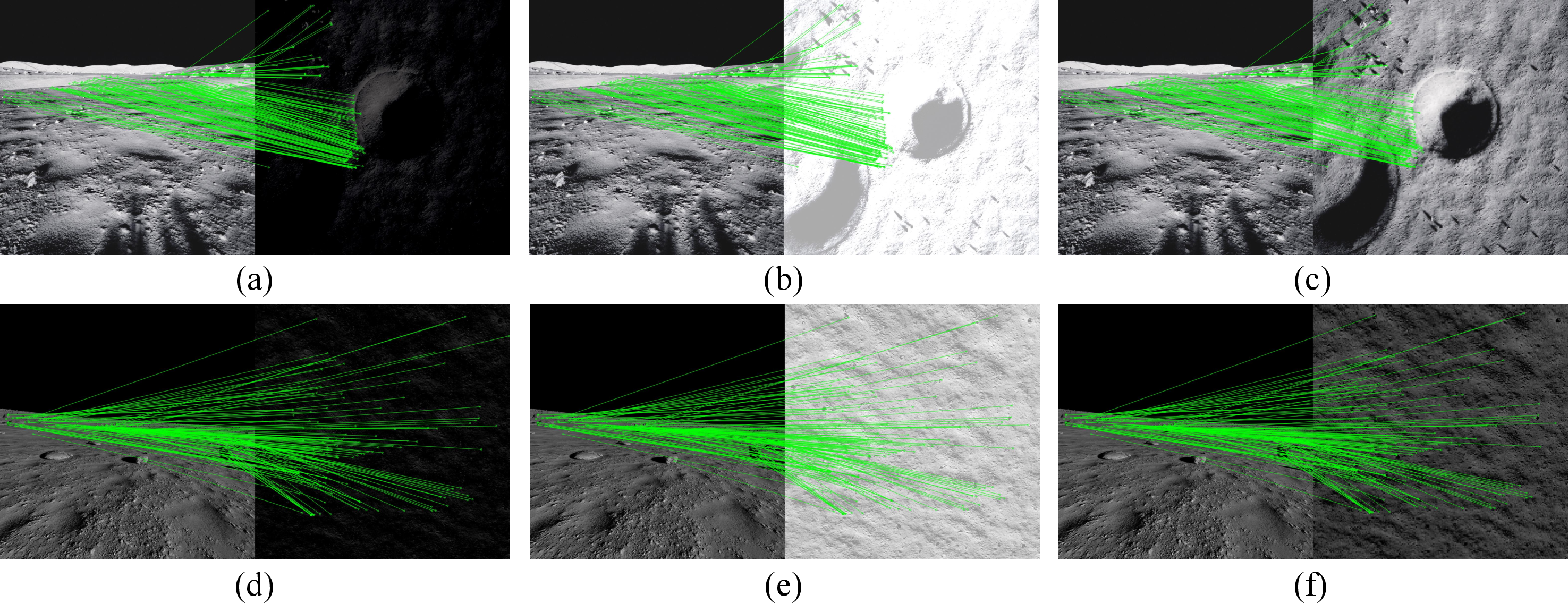
Figure 8: Qualitative matching under strong illumination and scale discrepancy.
Comprehensive sensitivity analysis shows cosine similarity between corresponding features is preserved over a broad spectrum of lighting intensities and satellite resolutions.
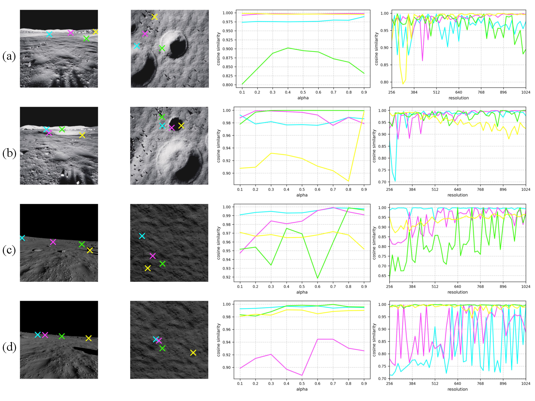
Figure 9: Quantitative feature stability as a function of illumination and input resolution, demonstrating invariance in challenging conditions.
Emergent Spatial Intelligence
Notably, WARG demonstrates emergent capabilities beyond explicit localization:
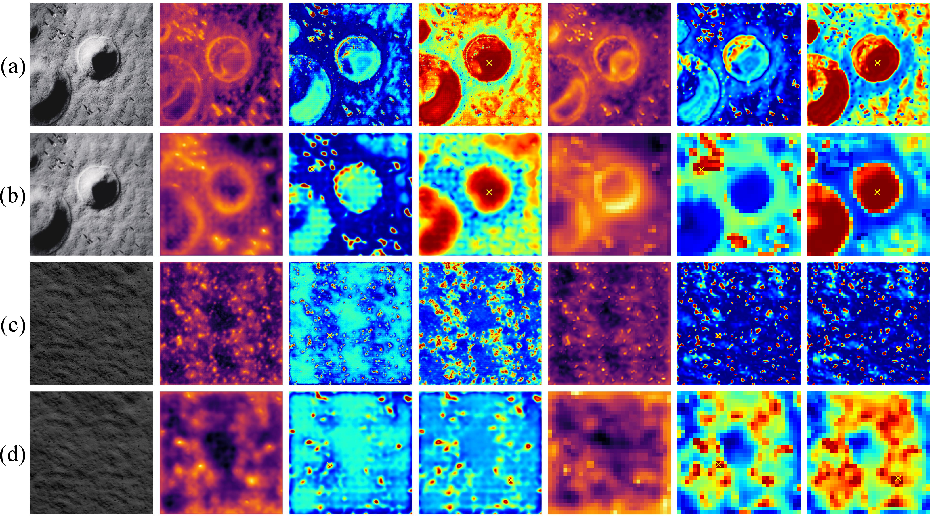
This emergent spatial reasoning suggests WARG's cross-view localization task functions as a highly effective self-supervisory proxy for scene segmentation and understanding in planetary vision. The internal representations far exceed the baseline feature encoder (DINOv3) in granularity and semantic selectivity.

Figure 11: DINOv3 backbone—limitation to proximity-based grouping absent higher-order semantic awareness.
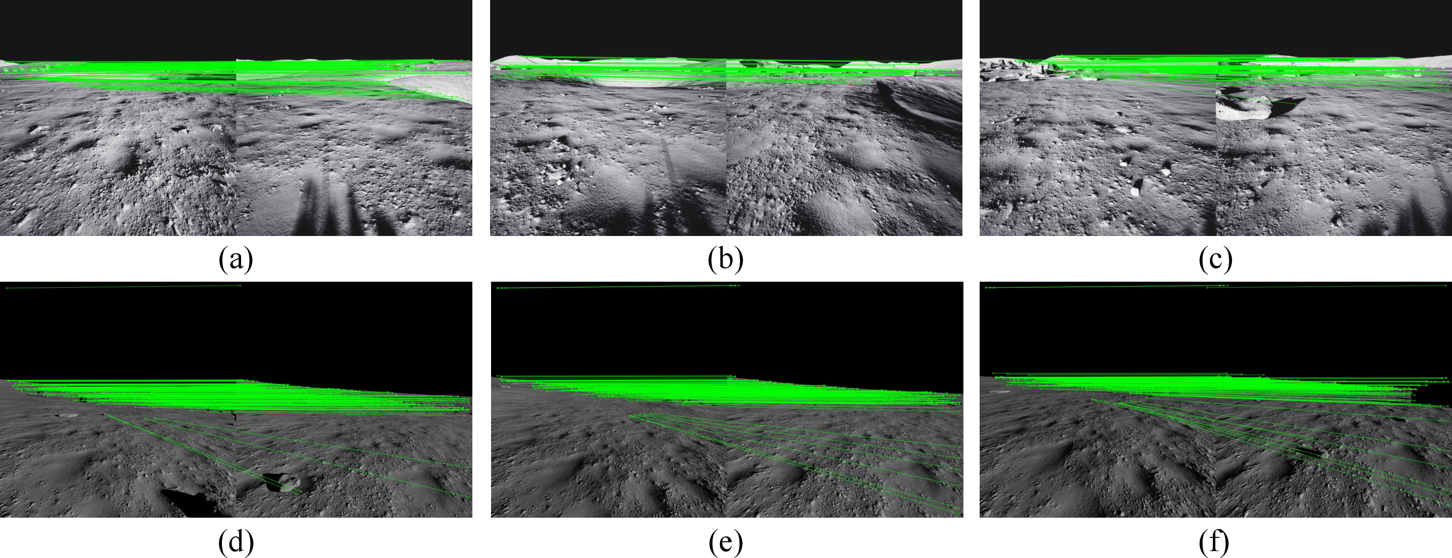
Figure 12: Ground-to-ground correspondence visualization—robust structural reasoning between rover perspectives.
Sensitivity and Ablation Analyses
Ablation studies confirm the importance of architectural components:
- Increased graph node count improves robustness and reduces outliers.
- Weight sharing between rover and satellite pathways is critical; independent-weight models catastrophically fail under strong domain discrepancies.
- The method maintains high accuracy across a wide range of input resolutions and search region sizes, supporting operational flexibility.
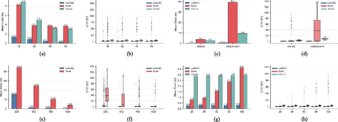
Figure 13: Ablation results for graph density, weight sharing, resolution, and search region size parameters.
Theoretical and Practical Implications
WARG addresses the prohibitive annotation costs associated with dense pixelwise or semantic label supervision by inducing high-level spatial understanding through cross-view localization alone. This establishes a compelling paradigm for learning spatial intelligence in environments where manual supervision is infeasible, such as extraterrestrial surfaces.
The practical applicability is underscored by robust generalization to real data, high computational efficiency, and resilience to severe perceptual degradation. The theoretical insights—especially the role of structural learning and weight sharing—provide a foundation for further advances in GNSS-free navigation, as well as downstream spatial reasoning tasks relevant for multi-robot coordination, constrained landing, and autonomous scientific exploration.
Conclusion
"Globally Localizing Lunar Rover in Pixels via Graph Alignment" (2606.10602) presents a technically robust, graph-based cross-view localization framework for lunar exploration. By reframing pixel-level localization as a structural graph alignment problem and enforcing symmetric, invariant representation learning, WARG sets a new benchmark in accuracy, efficiency, and generalizability for planetary robotics. The observed emergence of semantic and structural spatial intelligence through cross-view learning signals promising directions for self-supervised scene understanding, generative navigation frameworks, and deployment of autonomous agents in GNSS-denied environments, both in space and on Earth.