- The paper presents Meridian, introducing a metric-semantic primitive matching framework for robust cross-view geo-localization in both urban and natural settings.
- It integrates advanced segmentation tools like Segment Anything and DINOv2 with geometric mapping to extract and match aerial and ground primitives without environment-specific training.
- Results demonstrate fine-grained localization accuracy (2–3 m RMS ATE) over diverse terrains, indicating its strong potential for autonomous navigation in challenging scenarios.
Metric-Semantic Primitive Matching for Cross-View Geo-Localization in Unstructured Environments
Introduction
The paper presents Meridian, a metric-semantic primitive-based framework for cross-view geo-localization, addressing a critical need for globally consistent robot localization in environments where GNSS signals are unreliable or unavailable. Unlike most existing methods focusing on structured urban settings and leveraging environment-specific models or high-level priors, Meridian generalizes to both urban and natural environments, including areas with repetitive geometries or limited distinct features. The method operates without environment-specific training or fine-tuning, relying solely on aerial orthophotos and onboard RGB-D or LiDAR sensors.
Pipeline and System Overview
Meridian's pipeline consists of three primary modules: sparse primitive extraction, metric-semantic matching and registration, and robust pose graph optimization (RPGO). Both ground and aerial sensory data are abstracted into semantically labeled points and lines, with object centroids and region boundaries serving as the core primitives. For aerial images, state-of-the-art segmentation and vision foundation models (e.g., Segment Anything, DINOv2) are used to derive these features, while ground-level segments are aggregated via RGB-D mapping and projected to 2D for consistency with the aerial modality.
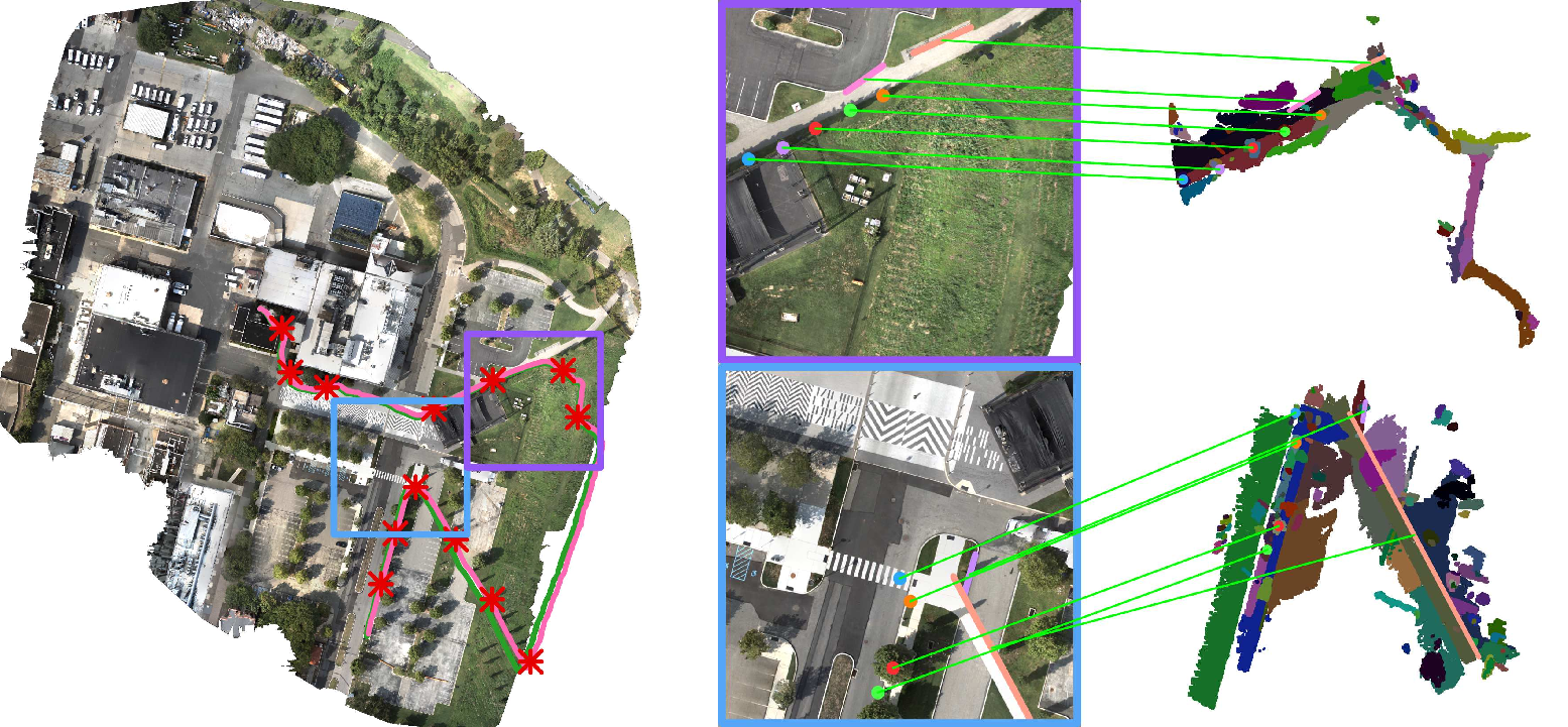
Figure 1: Overview of mapping and semantic/geometric primitive matching between aerial and ground views.
This environment-agnostic abstraction enables robust data association across modalities, forming the basis for downstream localization and mapping.
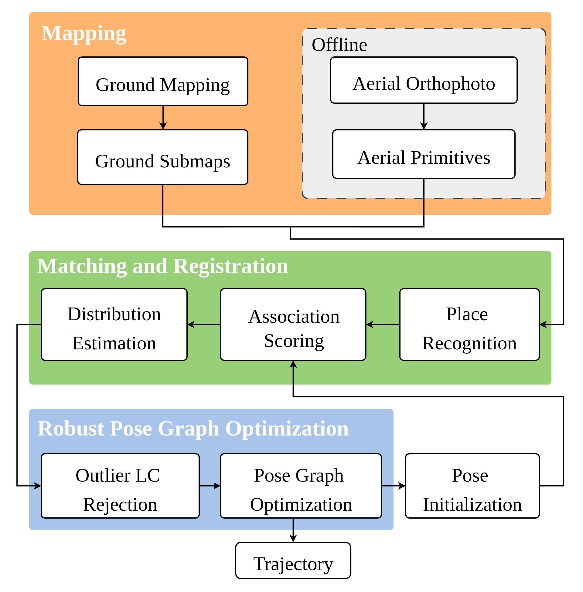
Figure 2: Schematic of the end-to-end pipeline: extraction of primitives, matching, registration, pose graph optimization, and trajectory estimation.
Primitive Extraction and Representation
Aerial images are partitioned into overlapping patches and processed using Segment Anything to extract both small (object-centric) and large (area boundary) segmentations. Small objects yield centroid points; large areas define boundaries, which are approximated by coarse 2D lines following geometric and semantic aggregation. DINOv2 embeddings are then attached to every primitive, supporting open-set semantic matching.
Ground primitives are generated by mapping 3D segment point clouds, grouped incrementally into submaps. These are projected to 2D and converted to points and lines with analogous criteria as aerial extraction, accounting for camera field-of-view and range-induced artifacts.
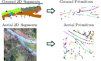
Figure 3: Illustration of point and line primitive extraction in aerial and ground maps, showing cross-domain consistency.
Data Association and Matching
Primitive matching proceeds via a two-stage process: aerial-ground candidate selection using AnyLoc descriptors, and fine-grained association using a novel pairwise consistency metric. Candidate associations comprise the top-K semantically similar primitive pairs, which are then scored for geometric consistency.
The paper advances beyond the affine Grassmannian metric by introducing bounded-line-aware consistency, wherein association scores combine angular and translational invariants. Directional consistency is assessed via angle difference checks invariant to the reference frame, while translational invariants are based on nearest-point distances between primitives—robust to both translation and rotation, and capable of integrating coarse priors when available.
A mutual consistency graph encodes association quality and pairwise agreement. Outlier rejection is then solved as a densest subgraph problem, with inlier sets sampled via approximate Bayesian inference for downstream uncertainty propagation.
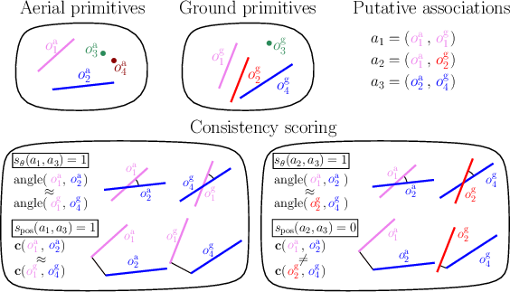
Figure 4: Visual intuition for point and line association consistency: only pairs with both angular and translational congruence are retained as inlier hypotheses.
For each proposed inlier association set (particle), a 2D similarity transform (rotation + translation) between submap and aerial patch is estimated via least-squares using both points and lines (the latter via Plücker coordinates). To resolve ray direction ambiguity and degeneracy, combinatorial checks on minimal primitive subsets are employed, with final selection via aggregated registration error. Clustering pose estimates yields a potentially multimodal distribution, naturally reflecting ambiguities in cross-view data association.
Robust Pose Graph Optimization
All loop closure candidates (i.e., submap-to-aerial patch registration hypotheses) form the factors in a cross-view pose graph, where each hypothesized transform is weighted by its posterior. Inter-loop closure consistency is evaluated by chaining closed-form estimates with odometry edges, introducing noise scaling proportional to path distance—a key innovation for multi-kilometer scale traversals and odometric drift handling.
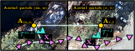
Figure 5: Cross-view pose graph construction, where each ground pose is constrained by odometry and multiple candidate aerial registrations, with hypothesis consistency assessed via transform chaining.
Outlier rejection in RPGO proceeds via an extension of the consistency graph approach. The system robustly identifies mutually consistent registration sets, prunes outliers, and performs pose graph optimization, yielding globally consistent robot trajectories.
Experimental Results
Extensive experiments cover urban (KITTI), semi-structured (Park/Campus), and natural (Camp A/B, with off-road traversal) datasets. Meridian consistently achieves fine-grained (2–3 m RMS ATE) final trajectory accuracy over >19 km of robot motion, with comparable or improved performance over both image-retrieval (FG²) and map/aerial-based (AnyLoc, OSM) baselines. Notably, in environments with few distinctive features or substantial seasonal and viewpoint variation, Meridian's primitive-based matching generalizes robustly without retraining.
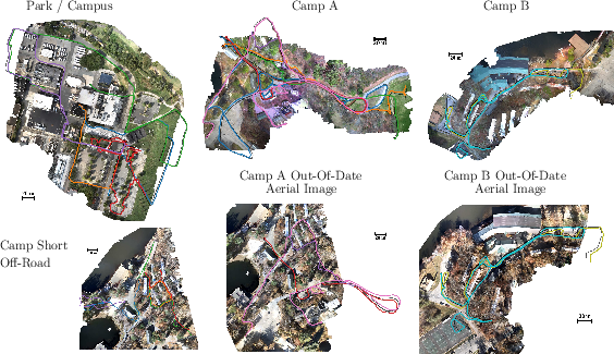
Figure 6: Example top-down views of self-collected aerial imagery with optimized multi-sequence ground robot trajectories; color coding indicates sequence, black denotes ground truth.
Region boundary (line) features substantially boost registration robustness, particularly in low-feature, off-road, or non-urban zones. Submap registration ablation studies confirm that omitting lines degrades performance across all environments. Integrating uncertainty scaling in the RPGO is found critical: disabling it leads to poor inlier recall and degraded final trajectory estimates.
Implications, Limitations, and Future Work
Meridian demonstrates that environment-agnostic, metric-semantic primitives constitute a powerful abstraction for cross-modal geo-localization, enabling robust performance in previously challenging scenarios—such as forests, fields, and temporally dynamic landscapes. The explicit probabilistic handling of matching ambiguity and registration multi-modality also opens the door to simple integration with probabilistic planners and collaborative SLAM stacks.
The primary current limitation is the recall of cross-view place recognition, which can result in computational inefficiency and missed loop closures. Additionally, the discriminativeness of semantic features (e.g., DINOv2) between ground and aerial imagery remains lower than for matched viewpoints, indicating an open challenge for cross-view open-set recognition. Future directions include improved learning-based cross-view descriptors, more efficient submap/aerial patch selection, and integration into heterogeneous multi-robot systems operating in natural environments.
Conclusion
Meridian introduces a robust, generalizable pipeline for cross-view geo-localization based on the matching of metric-semantic points and lines, achieving fine-grained global localization without area-specific training or infrastructure. The framework's solid empirical performance across urban and natural environments signals its capacity for wide applicability in autonomous robotics and long-range navigation tasks, motivating further development in open-set, low-prior, cross-modal spatial AI.

