- The paper demonstrates that sequential forward floating selection effectively reduces input dimensionality while improving landslide segmentation performance.
- It shows that an 8-channel subset, including key spectral bands and topographic features, outperforms larger, engineered feature stacks.
- This method enhances physical interpretability, mitigates the Hughes phenomenon, and streamlines deployment in resource-constrained environments.
Sequential Feature Selection for Efficient Landslide Segmentation from Multi-Spectral Data
The paper addresses a critical issue in satellite-based landslide mapping: deep learning models for segmentation are routinely fed with large, highly correlated spectral and topographic feature stacks derived from Sentinel-2 multispectral imagery and ALOS PALSAR terrain measures. In Earth observation pipelines, the standard practice has drifted towards appending various engineered indices (e.g., NDVI, BSI, moisture features) and structural cues (e.g., gradients, edge detectors) atop the raw spectral bands in the purported pursuit of improved discriminability. However, this practice is theoretically questionable, given the deterministic relationships and high mutual correlation among bands and indices. Over-dimensionalized input spaces exacerbate the Hughes phenomenon—where the curse of dimensionality actively deteriorates classifier performance when sample size is limited—while obfuscating physical interpretability and incurring intense computational overhead.
The paper frames the input channel selection problem as a principled search for a minimal, physically interpretable subset of features that preserves or improves landslide segmentation performance, departing from the prevailing paradigm that prioritizes maximal input dimensionality. Rather than relying on naive single-band drop tests or linear ablation, the authors implement a sequential forward floating selection (SFFS) procedure to evaluate candidate channel subsets in combination, directly optimizing validation F1 via a U-Net++ proxy.
Dataset and Feature Engineering
The primary benchmark is Landslide4Sense, comprising 3,799 global multispectral patches formatted as 128×128×14 arrays, with Sentinel-2 bands (B1–B12) at varying spatial resolutions and ALOS PALSAR-derived slope (B13) and elevation (B14) layers. Extreme class imbalance is observed: less than 3% of pixels are positive landslide instances, with a long right-tail distribution of patch-level sparsity, significantly complicating segmentation and motivating input channel sets with maximal class separability.
Sixteen engineered channels augment the benchmark: these include core indices (NDVI, NDMI, NBR), normalization transforms for visible bands, grayscale composites, Gaussian/median-smoothed representations, image gradients, edge maps, and further vegetation/water indices (SAVI, EVI, NDWI, MNDWI). The engineered candidates are physically grounded in vegetation loss, moisture shifts, soil exposure, and boundary structure hypotheses relevant to landslide mechanisms.
Baseline Architecture and Training Protocol
All experiments use U-Net++ with a ResNet-50 backbone, chosen for its superior performance (69.2% F1) compared to vanilla U-Net and the official competition reference. The models are trained under a strict protocol: class-weighted BCE and Dice loss, class-balanced sampling, hard-negative mining, and threshold optimization over validation sweeps to mitigate the pronounced imbalance. Candidate channel configurations are benchmarked using identical training and evaluation splits, precluding confounding from stochastic data partitioning.
Sequential Forward Floating Selection (SFFS) Procedure
The SFFS algorithm iteratively builds and prunes feature subsets, allowing for dynamic backward elimination of channels rendered redundant by subsequent inclusions. This is crucial given the high mutual correlation of raw and engineered multispectral bands. At each step, candidate additions are evaluated for maximal improvement in validation F1, followed by conditional backward deletion. The search halts when no further improvement is realized.
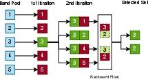
Figure 1: Sequential Forward Floating Selection (SFFS) procedure illustrating forward inclusion and floating backward elimination steps on the candidate pool.
Channels are categorized as "beneficial", "detrimental", or "redundant" according to their impact on validation F1, with tolerance thresholds to avoid overfitting to statistically insignificant variations.
Channel Selection Results and Feature Contribution Analysis
Application of SFFS yields a compact eight-channel subset from the candidate pool of 30 bands. Specifically, the model retains the following:
- B4 (Red), B5 (Red Edge), B8 (NIR), B11 (SWIR1), B13 (Slope), B14 (DEM)
- Band 21 (Grayscale composite)
- B3 (Green)
Most engineered indices—even commonly adopted vegetation and moisture features—are excluded as they are either redundant or detrimental when taken in combination with the raw spectral bands.
Permutation importance analysis quantifies the relative contribution of each retained channel. B4 (Red) emerges as the dominant spectral feature; B13 (Slope) and the grayscale composite also provide substantial utility. DEM and B3 rank lower, likely due to partial redundancy.
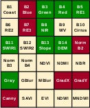
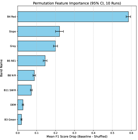
Figure 2: (a) SFFS-selected subset from the full 30-channel candidate pool; (b) permutation importance of each of the selected eight channels, showing mean F1 drop across five runs.
The selected 8-channel subset achieves 78.32% F1, outperforming the standard 14-band raw spectral baseline (77.2%), dense engineered configuration with 30 channels (77.3%), and the heavy 23-channel stack frequently used in current literature (78.1%). The result is robust across multiple independent runs, underscoring the stability of the SFFS solution.
Physical Interpretability and Theoretical Implications
The SFFS outcome aligns with known physical cues: B4 (Red) is directly associated with vegetation loss and bare soil exposure, while slope is a key driver for geomorphic failure. The strong contribution of the grayscale composite is notable, suggesting that simplified representations of brightness contrast are more valuable than highly specialized engineered indices. Many deterministic indices (NDVI, NDMI, NBR, etc.) are excluded, echoing observations in remote sensing literature that they offer no new information relative to their constituent bands.
Structural features (gradients, edges) are also excluded, implying that boundary information is adequately captured by spectral contrast in this context. The behaviour of the excluded blue band and its normalized equivalent is tentatively attributed to atmospheric scattering effects.
Notably, the study empirically confirms the Hughes phenomenon: increasing input dimensionality with correlated or redundant features not only fails to improve performance but can actively degrade it—a conclusion supported by the marginal improvement of the SFFS-reduced input over larger feature stacks.
Practical Deployment and Future Directions
The findings advocate for parsimonious, physically interpretable input sets in operational landslide segmentation systems. This has implications for storage, preprocessing efficiency, and deployment in resource-constrained environments. The compact input representation is also more amenable to transfer across sensors and easier to troubleshoot in practical disaster response settings.
Several avenues for extension are identified: verifying generalizability across alternate datasets and architectures, examining the stability of selected channel subsets under transfer learning scenarios, and expanding candidate feature pools to explore the limits of engineered index utility.
Conclusion
This paper presents a systematic, explainable channel selection framework for satellite-based landslide segmentation, demonstrating that careful subset selection via SFFS outperforms standard input configurations relying on maximal channel stacking. The key finding is that an 8-channel subset—including select spectral bands, slope, DEM, and a grayscale composite—is sufficient to match or exceed segmentation quality compared to broad engineered and raw band stacks. The study provides evidence that the conventional practice of appending all engineered indices is counterproductive, supporting the adoption of principled feature selection methods in remote sensing deep learning pipelines. The implications are clear for both theoretical understanding of classifier behaviour in high-dimensional settings and practical development of more efficient, interpretable segmentation systems.
(2605.09746)