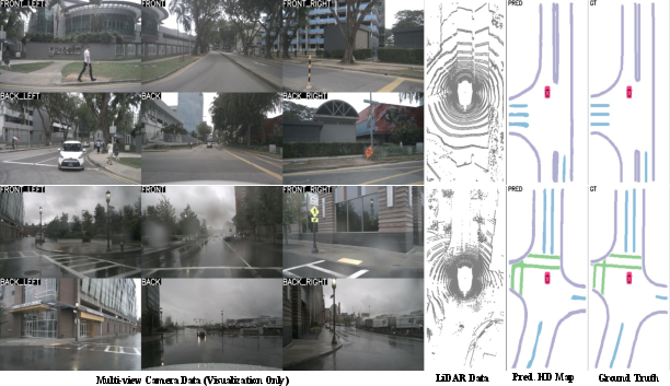
- The paper introduces a two-branch framework that uses online knowledge distillation from 2D LiDAR intensity maps to enhance LiDAR-only semantic segmentation.
- The paper demonstrates significant performance gains, achieving 58.0 mIoU and outperforming camera-based baselines by +8.2% under various conditions.
- The paper validates real-time deployment at 36 FPS and strong cross-dataset adaptability through effective fusion of geometric and reflectivity features.
LIE: LiDAR-only HD Map Construction with Intensity Enhancement via Online Knowledge Distillation
Problem Definition and Motivation
Online HD map construction is essential for autonomous driving, requiring robust, accurate, and up-to-date semantic maps of static environmental elements. While camera-based map segmentation models benefit from dense semantic cues and established architectures, they are fundamentally limited by the lack of geometric depth and poor transferability across sensor setups and environmental conditions. LiDAR, with its precise 3D geometry, offers key advantages for reliable, platform-agnostic BEV representations but suffers from a representational gap due to sparse, textureless point clouds.
The LIE framework directly addresses the under-exploitation of LiDAR intensity information. It proposes using knowledge distillation from offline-generated 2D LiDAR intensity maps—available during training—to guide a LiDAR-only segmentation model without requiring continual intensity map inputs at inference. This approach aims to integrate strong geometric and reflectance priors into real-time, robust, and generalizable LiDAR-only HD semantic map construction.
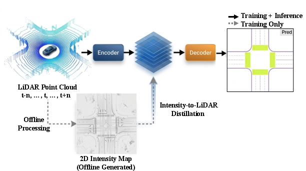
Figure 1: LIE leverages intensity-to-LiDAR online knowledge distillation during training, using only the LiDAR branch at inference, in contrast to fusion paradigms.
Methodology Overview
Architecture Components
LIE is a two-branch knowledge distillation framework. The "teacher" branch fuses real-time LiDAR features with dense, precomputed intensity maps using a multi-scale BEV decoder and a position-guided cross-modal attentional fusion module (PGxMF). The "student" branch processes only LiDAR data, using a similar BEV decoder but without direct access to the intensity map at inference. Both branches are trained jointly, with feature- and logit-level online distillation aligning their outputs.
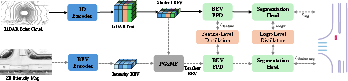
Figure 2: LIE’s training pipeline, distilling geometric and reflectivity-based structure via fusion-based supervision; only the LiDAR branch is used at test time.
Dynamic voxelization and a PointPillars-based backbone encode 3D LiDAR points, converting them into pseudo-image BEV representations.
Intensity Map Encoding
2D BEV intensity maps—gridded maximum reflectance projections—are processed with a Swin Transformer backbone and FPN, capturing lane-level reflectivity patterns.
Position-Guided Cross-Modal Fusion (PGxMF)
PGxMF fuses BEV features from both modalities using relative positional encodings and attentional feature fusion to capture corridor-level contextual cues necessary for semantic delineation.
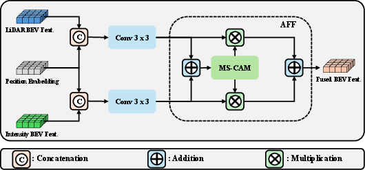
Figure 3: PGxMF enables BEV-level attention-driven integration of LiDAR and intensity features for effective knowledge distillation.
Online Knowledge Distillation
- Feature-level distillation: Multilevel BEV features from the student and teacher are aligned using a learnable tree filter that constructs global and local affinity matrices via minimum spanning trees, enforcing structural consistency.
- Logit-level distillation: Soft distributional alignment between teacher and student semantic predictions via KL divergence facilitates nuanced class boundary learning.
During inference, only the streamlined LiDAR branch is deployed, eliminating reliance on dense maps and maintaining low-latency execution.
Experimental Validation
Main Results
LIE sets a new standard in LiDAR-only semantic HD map construction. On nuScenes, the method achieves 58.0 mIoU—outperforming all published camera-only baselines by +8.2%, and surpassing LiDAR2Map (which uses multi-camera distillation) by +0.6% using the same PointPillars backbone and no camera inputs.
Robustness and Range
LIE maintains reliable performance:
Vectorization and Cross-Dataset Transfer
Despite being trained with raster representation, LIE’s predictions can be vectorized to yield map-level APs that are competitive with end-to-end vector-prediction models like VectorMapNet and MapTR:
- On the nuScenes validation set, LIE achieves a mAP of 53.2 at standard thresholds—outperforming camera-based vector map methods.
When fine-tuned with only 10% of Argoverse2 data after nuScenes pretraining, LIE surpasses camera-based models trained on the full set, demonstrating strong cross-dataset adaptability.
Ablation and Efficiency
- Logit- and decoder-level feature distillation each contribute separately to performance, with the combination via PGxMF achieving the maximal 58.0 mIoU.
- LIE runs at 36 FPS on RTX 4090 and is feasible for real-time deployment, with low inference and training overhead compared to fusion-based methods that require larger architectures and higher resource consumption.
Theoretical and Practical Implications
LIE decisively demonstrates that the sparsity and apparent lack of semantics in LiDAR data can be largely overcome by targeted distillation from reflectivity-derived mid-level signals. It refutes the prevailing view that texture or appearance information from cameras is indispensible for fine-grained BEV map segmentation and establishes intensity-centric distillation as a viable alternative for geometric tasks.
Practically, LIE’s architecture enables deployment on a broader range of platforms—especially those with heterogeneous or minimal camera setups—reducing system complexity, calibration requirements, and failure modes stemming from visual domain shifts. The approach is inherently robust to sensor configuration variance and environmental shifts, as evidenced by strong transferability and long-range reliability.
Limitations and Future Directions
The current instantiation of LIE does not exploit sensor-specific augmentations or joint camera-LiDAR training, which could yield further improvements, especially in rare-case or cross-domain scenarios. The reliance on offline precomputed intensity maps for teacher supervision may limit on-the-fly domain adaptation in environments without such priors.
Future research avenues include:
- Expanding multi-dataset, multi-modal training regimes to further improve generalization.
- Integrating temporal fusion or SLAM priors for scene-consistent predictions during dynamic maneuvers.
- Exploring efficient online estimation of intensity priors, or adaptation to high-resolution, next-generation LiDAR streams.
Conclusion
The LIE framework represents a significant advancement in LiDAR-only HD semantic map construction for autonomous driving. Through intensity-to-LiDAR online distillation, it closes the semantic gap conventionally addressed by camera inputs while achieving state-of-the-art performance with high computational efficiency, robustness to adverse conditions, and strong cross-domain adaptability. This paves the way for more modular, cost-effective, and generalizable map infrastructure in autonomous vehicle stacks.
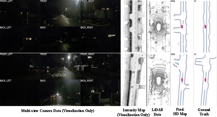
Figure 5: LIE’s predictions preserve geometric structure even when ground-truth annotations are inconsistent, leading to robust qualitative results but potential annotation-induced score penalties.