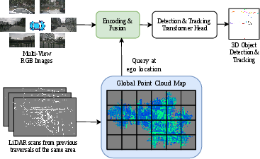
- The paper introduces DualViewMapDet, which fuses offline LiDAR map priors with multi-view camera features to mitigate depth ambiguity.
- It employs dual-space fusion using perspective view and bird’s-eye view encodings combined with deformable attention for robust 3D localization.
- Experimental results on nuScenes and Argoverse 2 demonstrate significant improvements in detection accuracy, localization precision, and tracking performance.
Dual-Space Fusion of Prior Point Cloud Maps for Camera-Only 3D Object Detection and Tracking
Introduction
The paper "Leveraging Previous-Traversal Point Cloud Map Priors for Camera-Based 3D Object Detection and Tracking" (2604.25405) introduces DualViewMapDet, a framework designed to mitigate depth ambiguity in camera-only 3D object detection and multi-object tracking. In the context of autonomous driving, typical approaches using multi-view cameras lack precise metric depth, which fundamentally constrains accurate object localization and tracking compared to methods that rely on online LiDAR. However, repeated traversals in real driving scenarios allow the offline construction of high-resolution static LiDAR point cloud maps, creating an opportunity to inject strong geometric priors into image-based perception models—substantially narrowing the performance gap without LiDAR at test time.
Methodology
Camera-Map Dual-Space Fusion
The primary technical advancement is a dual-space fusion mechanism (Figure 1) combining two complementary perspectives:
Detection Head and Data Flow
A transformer-based detection head operates with sparse, object-centric queries. Deformable attention aggregates context first from the fused BEV then from the fused PV features, maximizing utilization of metric geometry for localization and PV semantics for recognition.
Crucially, map features do not contain current dynamic object information; they encode only the static background. The architectural choice to fuse in both PV and BEV, followed by sequential attention, avoids the representational bottlenecks of PV-only (limited geometric aggregation) and BEV-only (semantic attenuation) strategies. It also resolves view conversion issues, leveraging complementary strengths of each space.
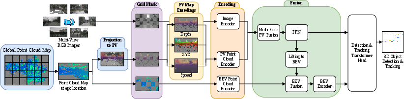
Figure 3: DualViewMapDet employs multi-channel PV and sparse voxel BEV encoders with sequential fusion and deformable aggregation for robust 3D detection.
Map Construction and Robustness
The static map is constructed from aggregated LiDAR readings with dynamic points explicitly filtered out. During inference, the map is discretized into spatial tiles, patched around the current ego pose, and filtered to remove artifacts or possible 'leakage' from adjacent traversals.
To counteract dependency on perfect map priors, the authors apply grid masking augmentation to both image and map channels during training. This increases robustness to missing or incomplete priors, a common real-world failure mode.
Training and Inference Regimes
DualViewMapDet is trained end-to-end with detection and image-based depth supervision, but at inference, it requires only multi-view RGB, localization, calibration, and the retrieved local map. No online LiDAR is utilized.
Experimental Results
The framework is evaluated on nuScenes and Argoverse 2 and benchmarked against top camera-only models, including Sparse4Dv3, StreamPETR, Far3D, and BEVFormer. Strong quantitative gains are demonstrated across multiple metrics and both short-range (50 m) and long-range (150 m) evaluation regimes.
On nuScenes, DualViewMapDet achieves higher NDS (0.588 vs. 0.561 / 0.553 for variants of Sparse4Dv3) and mAP (0.481 vs. 0.469 / 0.447), with notable improvements in localization (mATE drops from 0.553 to 0.484). Tracking performance also improves, raising AMOTA to 0.513.
On Argoverse 2, improvements are similarly pronounced, especially in subsets with dense map prior coverage. For example, in the 50 m regime, DualViewMapDet reaches a CDS of 0.311 (vs. 0.294), mAP of 0.397 (vs. 0.381), and mATE of 0.622 (vs. 0.706). In both full and high-overlap subsets, the margin increases with better prior coverage, underpinning the central claim that geometric anchors from the static map reduce depth mislocalization of dynamic objects.
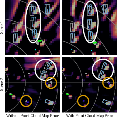
Figure 2: Map priors provide stable geometric anchors that significantly reduce depth distortion of car detections relative to image-only baselines.
Qualitative examples (Figure 4) illustrate improved 3D box tightness, especially under severe occlusion or at long distances.
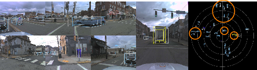
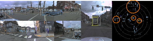
Figure 4: DualViewMapDet yields accurate 3D box alignments and tracking, with orange boxes from DualViewMapDet closely following ground truth compared to competitive baselines.
Ablation Study and Analysis
The ablation analysis confirms that:
- PV fusion alone provides limited gains unless the PV map encoding is explicitly enhanced with local coordinate, spread, and embedding features.
- BEV-only fusion substantially aids metric localization, but the joint dual-space approach yields the greatest improvements.
- The dual fusion design is necessary not only for strong performance but also for architectural robustness.
- Performance scales with the density and accuracy of the prior map. Regularization with grid masking is essential to prevent overfitting to priors, maintaining competitive results if the map is unavailable at deployment.
Implications and Future Work
Practically, DualViewMapDet enables deployment of camera-only perception stacks with detection and tracking accuracy previously achievable only with online LiDAR. This substantially reduces hardware cost and energy requirements while facilitating operation in mapped environments with frequent revisits—an assumption valid for most urban autonomous driving applications.
From a research perspective, the work signals a pivot from multi-modal sensor fusion to sensor and prior fusion, raising important questions about optimal architectures for leveraging static geometric priors, coverage completeness, and pose alignment. The explicit dual fusion strategy highlights that naïve concatenation of representations is suboptimal; architectural subtleties governing metric and semantic information flow will be central for future progress in map-aware perception.
Possible directions include real-time updating of map priors, online map validation, and broader exploitation of prior representations for other peri-perceptual tasks such as occupancy, segmentation, and non-autonomous robotics.
Conclusion
DualViewMapDet presents a robust, dual-space fusion framework for integrating prior static LiDAR maps into camera-only 3D object detection and tracking pipelines. By developing novel PV and BEV map encodings and a sequential fusion architecture, the method consistently improves localization precision and robustness across several large-scale benchmarks. Theoretical and experimental analysis confirms the necessity of dual-space representation and the practical value of prior geometric anchors, establishing a new architectural baseline for future research in map-based camera-only 3D perception.