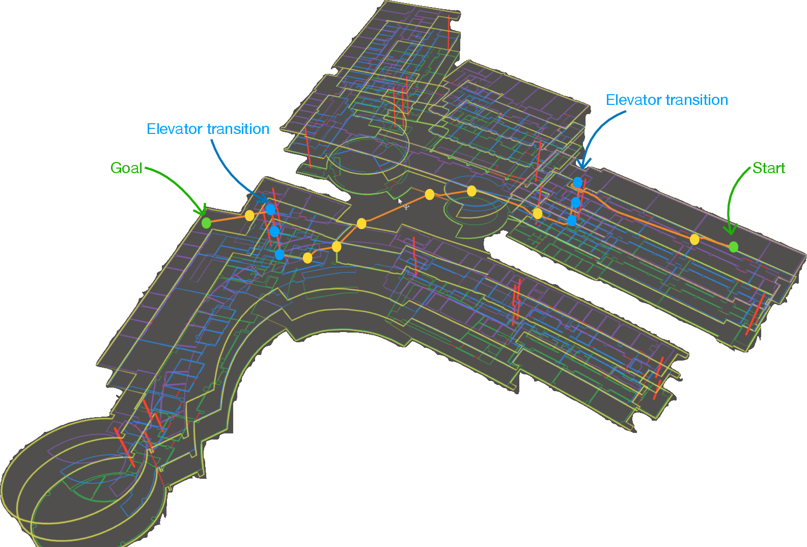
- The paper introduces a modular ROS2-based navigation stack that decouples global semantic planning from local kinematic execution.
- It implements a hierarchical, passage-centric planning algorithm that achieves millisecond-level planning latency even on large-scale indoor deployments.
- The system features robust lifelong localization and efficient map usage with scalable vector representations derived from automated CAD-to-osmAG pipelines.
Hierarchical Semantic Topometric Navigation for Robust Lifelong Indoor Autonomy: A Technical Synthesis of "osmAG-Nav"
Introduction and Motivation
Autonomous navigation in large-scale, multi-floor facilities exposes the inherent deficiencies of conventional occupancy-grid-based systems—primarily their lack of semantic abstraction, limited scalability, and weak vertical reasoning. "osmAG-Nav: A Hierarchical Semantic Topometric Navigation Stack for Robust Lifelong Indoor Autonomy" (2603.28271) addresses these issues via a paradigm shift from monolithic, purely geometric representations to a system-of-systems architecture centered around the OpenStreetMap Area Graph (osmAG) standard. This stack is architected for ROS2 and decouples deliberative, hierarchical topological planning from local kinematic execution using a vectorized structural map, supporting both efficient, scalable global routing and robust lifelong localization in dynamic or degenerate environments.
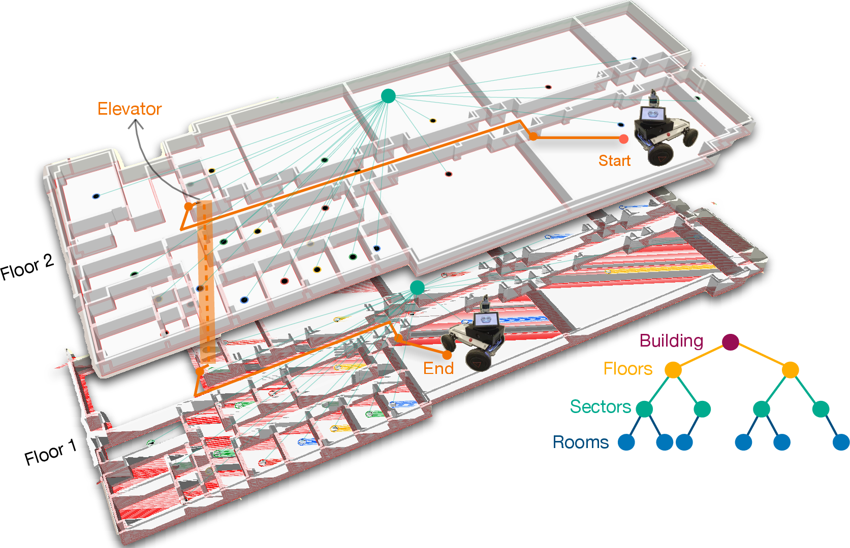
Figure 1: Hierarchical multi-floor navigation with osmAG-Nav, leveraging a semantic hierarchy for efficient cross-floor topological routing and maintaining a bounded local metric footprint.
The osmAG Standard: Hierarchical Semantic-Topometric Vectorization
osmAG defines a semantically and hierarchically structured representation using areas (rooms, corridors, elevators, stairs, structural containers) as nodes and explicit passages as edges. It leverages OSM’s vector model to encode persistent architectural structure, vertical connectivity, and containment hierarchies. The core specification supports both navigation-oriented and embodied-AI semantic extensions, preserving compatibility with standard OSM authoring tools.
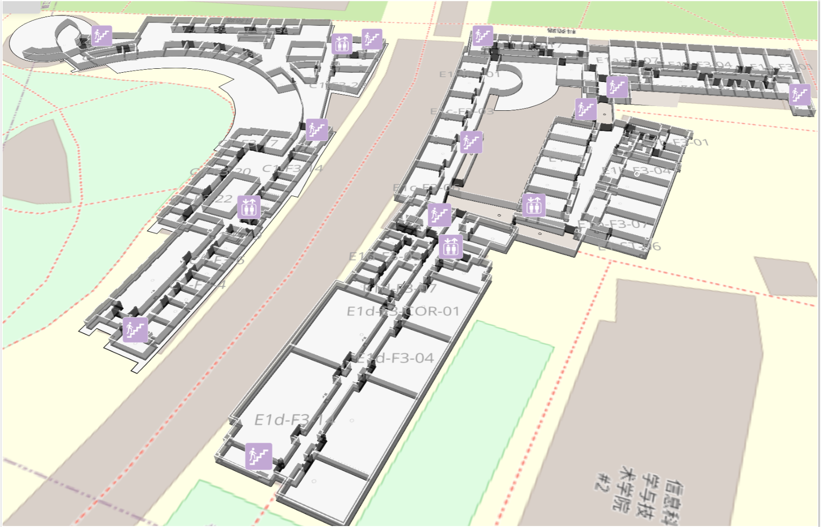
Figure 2: Example of an osmAG semantic-topological map rendered with OSM-compatible tools, exposing vertical semantics and editability.
The specification strictly enforces containment, disjointness, and passage-adjacency invariants to guarantee validity and facilitate robust hierarchical planning. Elevators and stairs are treated as first-class spatial primitives, supporting natively encoded inter-floor transitions without planner-side heuristics or fragile finite-state machinery.
System Architecture: Decoupled System-of-Systems Stack
osmAG-Nav employs a multi-layered architecture:
- Environment Layer: Holds the global sparse osmAG map and serves a Rolling Window occupancy grid for local metric execution.
- Deliberative Layer: Conducts semantics-aware, passage-centric planning and structure-based robust localization.
- Execution Layer: Remains standard Nav2, consuming dynamically served local costmaps and intermediate passage-centric goals dispatched through standard NavigateToPose actions.
ROS2-native topic, action, and TF interfaces tightly couple these layers, keeping Nav2 agnostic to the global topological map and ensuring system modularity.
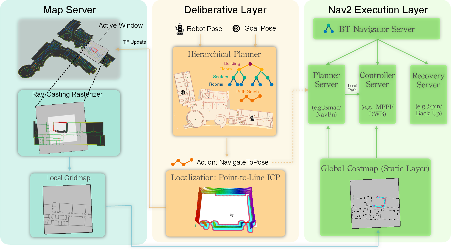
Figure 3: System architecture diagram, illustrating layered decoupling of map parsing, hierarchical planning, localization, and local metric execution via Nav2.
Hierarchical Planning Methodology: LCA-Pruned Passage-Centric Routing
The core planner implements a hierarchical, passage-centric search over the osmAG graph:
- Graph Construction: Passages (doors, corridor connections, elevator interfaces) serve as graph vertices; intra-leaf transitions are costed via rasterized A* over local occupancy grids, with vertical transitions treated explicitly.
- Hierarchical Query Decomposition: Queries initiate with start/goal pose localization, then recursively attach virtual transition nodes, lift search frontiers through hierarchical lift graphs, and converge via LCA-based compact-graph A* followed by expansion.
- Segmented Execution: The passage trace is realized through sequential goal dispatch; boundary-aware goal projection ensures goals remain inside the rolling window if the next passage lies outside the local costmap.
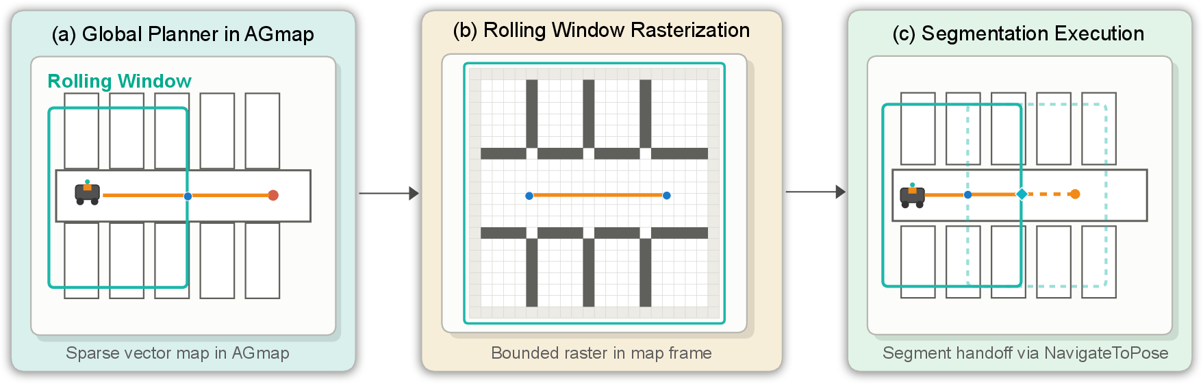
Figure 4: Topology-to-metric bridging—full-map planning in AGmap, bounded local rasterization for Nav2, and passage-goal projection as the robot moves.
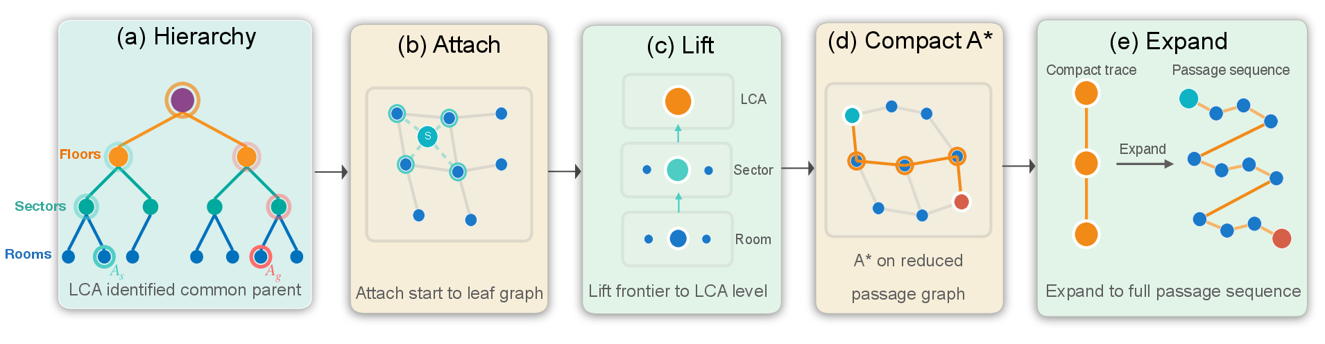
Figure 5: The LCA-based hierarchical planning workflow—demonstrating attach, lift, common-parent graph search, and trace expansion.
This method achieves low-millisecond planning even for long campus-scale queries. On real deployment in 11,025 m² environments, the system delivered up to 7816× reduction in planning latency over Nav2 Grid A* (from 10641 ms to 1.36 ms) for long routes, with only a minor path-length overhead (2.07%), and constant-time performance scaling with query complexity (see Table 1 and Figure 6 in the source; summarized here).
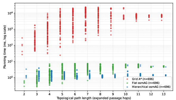
Figure 6: Planning latency and scalability benchmark—hierarchical osmAG planning maintains flat sub-2ms latency across complex routes, outperforming grid and flat planners.
Rolling Window and Metric Bridging
To reconcile the sparse topological graph with the local metric requirements of standard controllers, osmAG-Nav maintains a Rolling Window rasterizer: only a fixed-size local region is rasterized into an occupancy grid at runtime, decoupling local costmap memory from total environment size (O(1) memory scaling). Non-passage boundaries are marked as occupied, with passage segments explicitly reopened, ensuring robust traversability.
Structure-Aware Lifelong Localization
For robustness in dynamic and degenerate indoor environments, the system employs the AGLoc++ structure-aware LiDAR localization stack:
- Global Relocalization: Particle-based global search with coarse-to-fine structural matching.
- Online Scan-to-Map Tracking: Ray-consistency and point-to-line ICP with clutter removal, robust weighting (inside/outside gating), and corridor-aware degeneracy handling (direction-aware weighting and downsampling).
- Probabilistic Odometry Fusion: Adaptive weighting of ICP and wheel odometry, with cross-floor consistency filters.
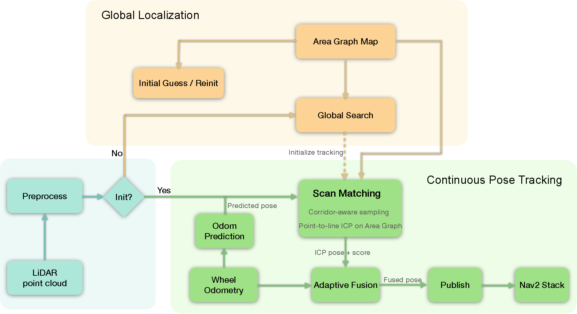
Figure 7: Localization robustness pipeline, combining initialization, structure-based tracking, corridor-aware matching, and confidence-based fusion.
Empirically, AGLoc++ reduced longitudinal corridor drift (ATE RMSE from 1.26 m to 0.36 m) and outperformed both the original AGLoc and AMCL in the most geometrically challenging sequences.
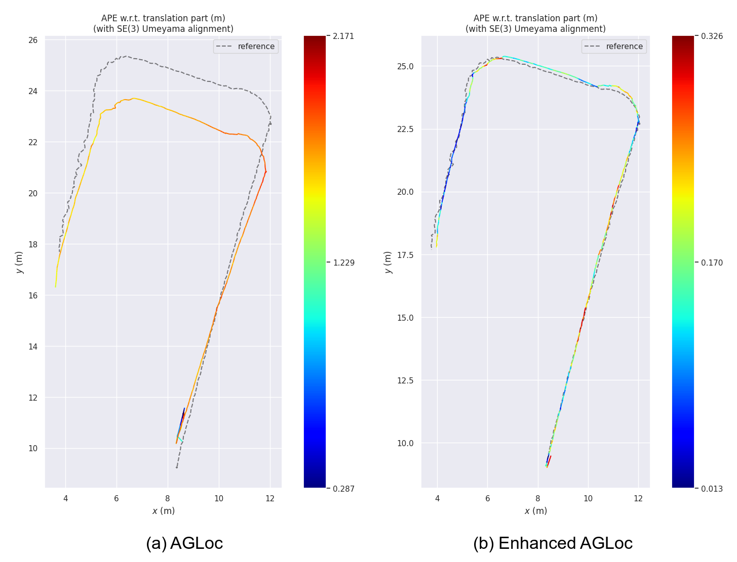
Figure 8: Comparative example in a degenerate corridor—AGLoc++ (osmAG-Nav) stays aligned with ground truth, suppressing drift evident in the baseline.
Automated CAD-to-osmAG Pipeline
Deployment is streamlined by an automated CAD-to-osmAG pipeline, extracting vector semantics from standard architectural floor plans, segmenting rooms/topology, and associating semantic metadata. This mitigates the “cold start” problem and supports rapid scaling to new facilities.
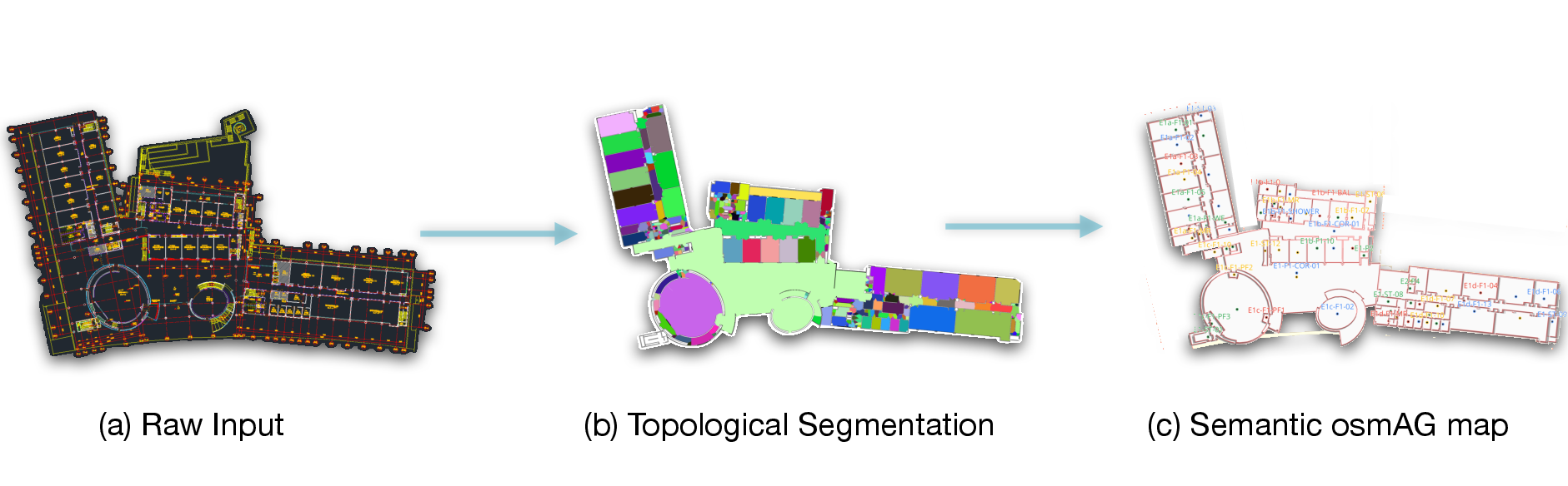
Figure 9: End-to-end automated map generation from raw CAD drawings to osmAG vector maps ready for deployment.
Experimental Validation
Limitations and Future Directions
Two primary limitations are highlighted:
- Structured Topology Requirement: The framework relies on the existence of meaningful area-passage segmentation. In highly open or amorphous settings, segmentation heuristics may not capture efficient navigational structure, impacting route quality.
- Static Topological Graph: While dynamic obstacles are robustly handled, permanent structural changes (added walls/doors) currently require offline map reprocessing; online lifelong topological updates remain future work.
Future work includes:
- Lifelong online map/graph update,
- Learning-based, context-aware routing costs using rich semantic osmAG annotations,
- Multi-robot fleet planning leveraging shared hierarchical topology, and
- Full real-world cross-floor execution (integrating elevator interaction, vertical introspection, and robust transition handoff).
Conclusion
osmAG-Nav constitutes a mature, open-source navigation stack for ROS2 that formally introduces and leverages the hierarchical, semantic topometric osmAG standard. By decoupling global topological planning from local execution and integrating a robust structure-aware localization backbone, it achieves bounded-memory, millisecond-latency planning and stable, long-term deployment in large real-world facilities. The architecture and empirical results demonstrate that topologically hierarchical, semantically-enriched environment representations are a critical and practical enabler for robust, scalable, and interpretable robot navigation in the built environment.
Reference: "osmAG-Nav: A Hierarchical Semantic Topometric Navigation Stack for Robust Lifelong Indoor Autonomy" (2603.28271).