- The paper introduces GeoFMs which use large-scale self-supervised pre-training followed by domain-specific adaptation to extract robust geospatial features.
- It employs methods like masked autoencoding and contrastive vision-language alignment to enable efficient, open-vocabulary image analysis.
- It discusses operational trade-offs, data bias challenges, and the integration of multimodal LLMs for achieving agentic geospatial reasoning.
The Emerging Paradigm of Geospatial Foundation Models: From Pre-Training to Agentic Reasoning
Foundation Model Lifecycle and Paradigm Shift
Geospatial Foundation Models (GeoFMs) introduce a paradigm shift in remote sensing analytics by leveraging large-scale pre-training and offering a clear separation between general-purpose model construction and domain-specific adaptation. The lifecycle is distinctly two-stage: computationally intensive, self-supervised pre-training produces a backbone capable of extracting powerful geospatial features, followed by lightweight adaptation—either via supervised fine-tuning or direct prompting—to specific mission requirements. This separation democratizes access to cutting-edge geospatial AI while preserving confidentiality for sensitive downstream tasks.
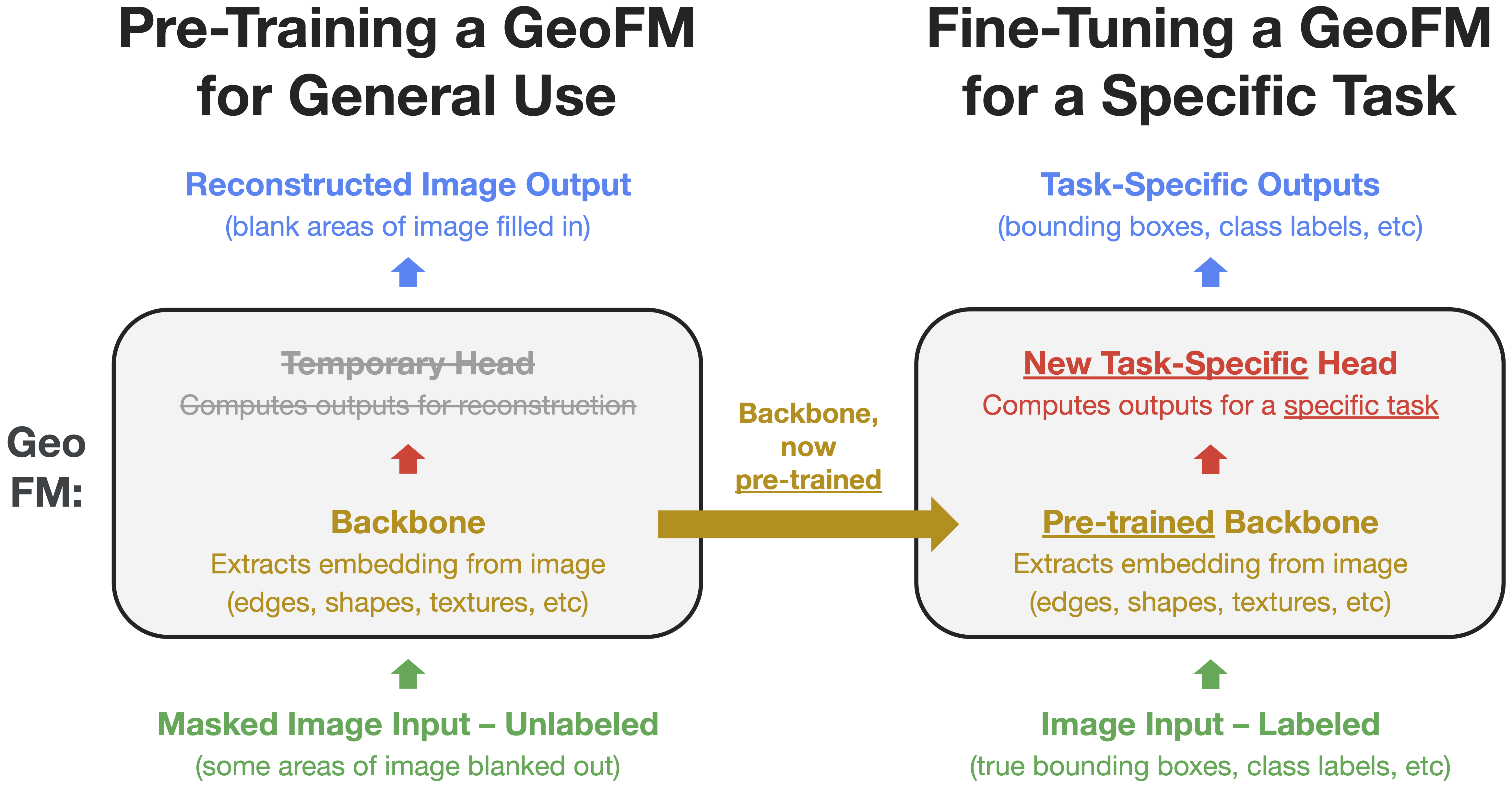
Figure 1: Two-stage lifecycle of vision GeoFMs: self-supervised pre-training followed by supervised fine-tuning on a small labeled dataset.
This foundational architecture leverages transformer-based models, particularly Vision Transformers, exploiting their capacity for modeling complex spatial dependencies typical of satellite and aerial imagery. Pre-training strategies fall into two dominant categories: self-supervised learning (SSL) via masked autoencoding, and contrastive vision-language alignment. SSL variants reconstruct masked patches, yielding robust, general representations, while contrastive models connect image semantics to text, allowing open-vocabulary inference. This architectural choice governs the adaptation capabilities and operational scenarios for GeoFMs.
Pre-Training Strategies and Existing Model Ecosystem
SSL-driven vision GeoFMs, exemplified by SatMAE, ScaleMAE, Cross-Scale MAE, and Prithvi-EO-2.0, advance global image embedding robustness through temporal, spectral, and scale-aware positional encodings, as well as multi-scale feature learning. DINOv3 demonstrates transferable visual representations learned from non-geospatial web images, with distinct improvements in high-resolution dense geospatial tasks. AlphaEarth Foundations diverges, producing static global embedding fields that serve as universal feature spaces rather than adaptable models per se.
Contrastive vision-LLMs, as typified by Google's Remote Sensing Foundations, unlock zero-shot and open-vocabulary analysis by constructing joint embedding spaces for images and text. This enables dynamic querying and flexible downstream use without retraining, fundamentally expanding operational capabilities.
Downstream Applications Unlocked by GeoFMs
GeoFMs support a suite of geospatial tasks:
- Image Classification: Scene-level assignment of class labels, demonstrating efficient adaptation via fine-tuning of model heads.
- Image Segmentation: Pixel-level classification enabling precise delineation of objects and regions (e.g., buildings, water bodies).
- Object Detection: Localizing and classifying individual objects with bounding boxes, achieved through adaptation of detection-specific heads.
- Open-Vocabulary Image Analysis: Leveraging vision-language GeoFMs for querying novel concepts absent from training using natural language prompts.
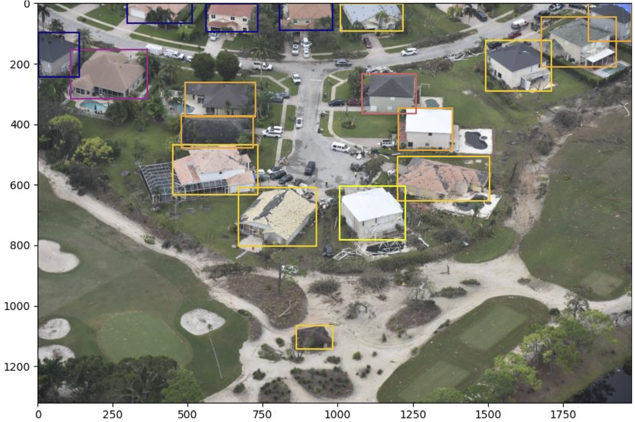
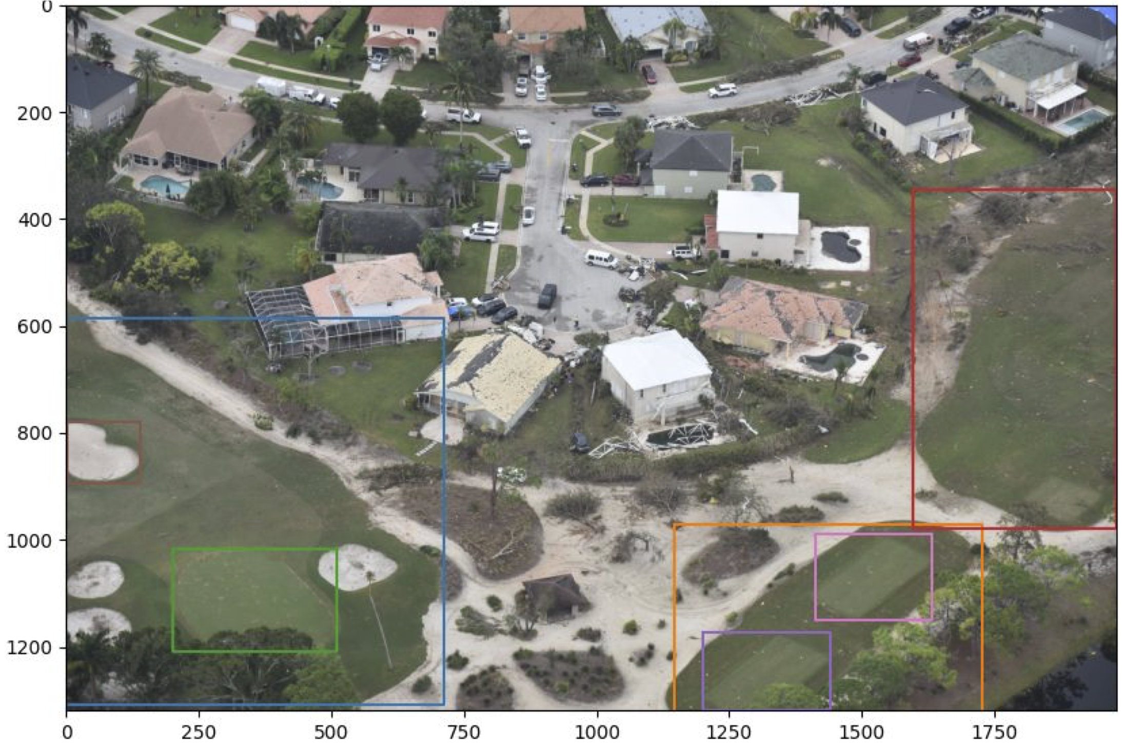
Figure 2: Open-vocabulary object detection with GeoFM: dynamically querying for "building" or "golf course" in the same image.
- Change Detection: Embedding comparisons across temporal imagery for quantifying spatial changes.
- Similarity Search: Database-wide search using embeddings as keys, enabling retrieval of visually or semantically similar scenes.
GeoFM deployment requires consideration of adaptation continuum: zero-shot inference, few-shot refinement, head-only fine-tuning, and full fine-tuning (often utilizing parameter-efficient methods like LoRA). Strategic choice among these is governed by empirical benchmarking and explicit performance-cost analyses, balancing up-front fine-tuning expenditures against cumulative inference costs.
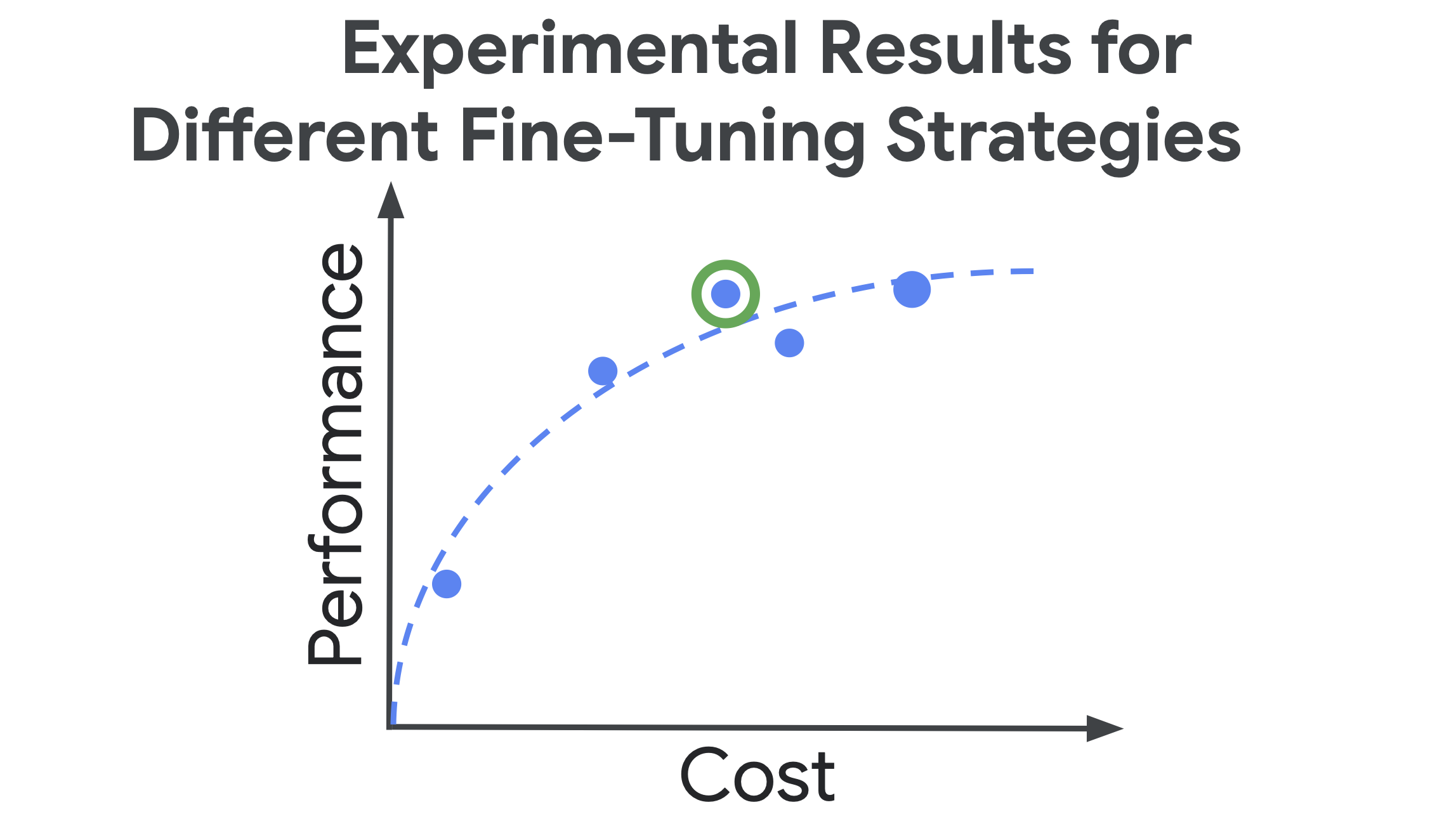
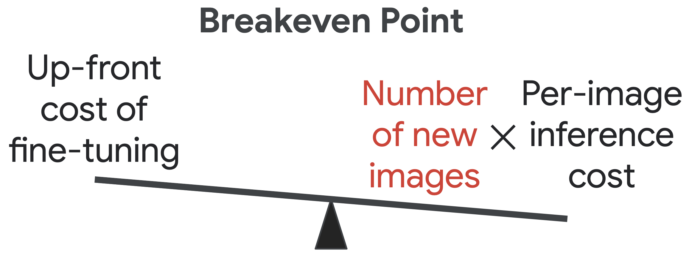
Figure 3: Performance-cost trade-off and breakeven analysis for various fine-tuning strategies.
A rigorous operational workflow integrates UX scientists, data scientists, ML specialists, and deployment engineers, each contributing to data curation, annotation, adaptation, optimization, and maintenance. GeoFMs are a core component, but successful operationalization rests on robust end-to-end MLOps, interpretability, uncertainty quantification, and strategic resource allocation.
Limitations and Open Research Challenges
Key unresolved challenges include:
- Data Bias and Representation: Geographic and seasonal imbalances in global pre-training datasets degrade generalization and exacerbate performance disparities for underrepresented regions and conditions.
- Computational Accessibility: Pre-training and large-scale inference costs restrict access for smaller organizations, partially mitigated but not eliminated by the separation-of-duties paradigm.
- Principled Uncertainty Estimation: Reliable spatial uncertainty quantification is essential for high-stakes deployment, yet remains an active research challenge.
- Interpretability and Explainability: The opaque, high-capacity representations typical of GeoFMs demand further research into trustworthy and auditable decision explanations.
Towards Agentic Geospatial Reasoning
Geospatial Reasoning leverages multimodal LLMs as orchestrators, automating complex analysis workflows based on natural language prompts. The agentic system decomposes high-level tasks—such as post-disaster damage assessment—into data retrieval, tool invocation, semantic enrichment, and report synthesis, utilizing GeoFMs for perception and embedding-based reasoning.
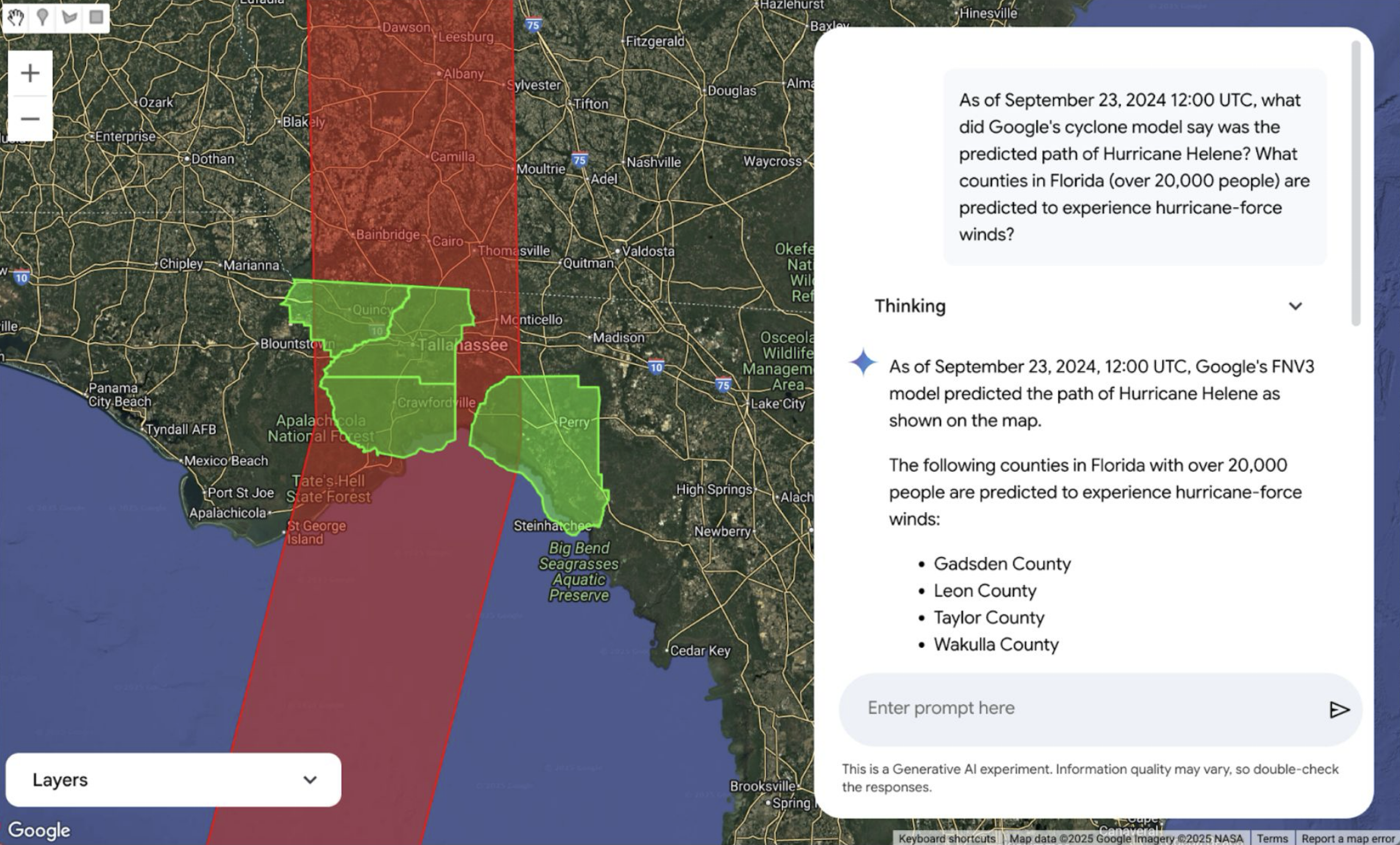
Figure 4: Conceptual user interface for agentic geospatial reasoning: user prompts trigger orchestration of GeoFMs and analytical tools.
This trajectory shifts geospatial analytics from straightforward perception to cognition, enabling holistic solutions for high-level geospatial queries and integrating multimodal data sources and analytical tools.
Conclusion
GeoFMs fundamentally alter the landscape of applied remote sensing, enabling data-efficient adaptation and flexible downstream deployment. Future directions emphasize development of truly foundational, modality-agnostic models, robust embedding spaces, and principled frameworks for agentic reasoning systems. Addressing bias, computational barriers, uncertainty, and interpretability will be crucial for fully realizing operational and scientific applications. As these systems mature, agentic geospatial reasoning will accelerate both operational intelligence and planetary-scale scientific discovery.

