Hydra++: Real-Time Hierarchical 3D Scene Graph Construction With Object-Level Shape Estimation
Abstract: 3D scene graphs provide a hierarchical abstraction of environments by encoding spatial entities, such as objects and places, and their relationships. However, existing scene graph systems model object geometry coarsely, relying on partial point clouds or class-level CAD templates, which limits instance-specific shape detail. This paper presents Hydra++, a system-level investigation into how learning-based object shape estimators can be integrated into a hierarchical 3D scene graph pipeline. Hydra++ incorporates category-agnostic shape estimation and a reprojection-mask consistency check to reject degenerate predictions from partial observations or imprecise segmentation. In its default CRISP-based configuration, Hydra++ performs online scene graph construction; slower estimators such as SAM3D are evaluated as modular alternatives to demonstrate generalization-latency trade-offs. Furthermore, to address the challenges of sparse and noisy depth measurements in outdoor environments, Hydra++ supports a hybrid LiDAR-camera configuration for large-scale operation, improving scene-level reconstruction quality. Experiments in both simulation and real-world outdoor campus scenarios demonstrate that Hydra++ improves object- and scene-level reconstruction quality. Project page is available at https://hydra-plusplus.github.io/.



Paper Prompts
Sign up for free to create and run prompts on this paper using GPT-5.
Top Community Prompts
Explain it Like I'm 14
What is this paper about?
This paper introduces Hydra++, a system that helps robots build smart 3D maps of the world in real time. These maps don’t just store where things are—they also record what things are (like chairs, cars, or plants) and what shape they are. Think of it like a living “scene graph,” a kind of digital map where objects are “nodes” and their relationships (like “next to” or “inside”) are the “edges.” Hydra++ adds a key skill: it fills in the full 3D shape of objects even when the robot only sees part of them.
What questions did the researchers ask?
They focused on three big questions:
- Can we make scene graphs that include detailed, object-specific 3D shapes instead of rough boxes or partial point clouds?
- Can we plug learning-based shape predictors into a real-time mapping system and keep the results reliable?
- Can we make this work outdoors, where depth data is sparse and noisy, by combining a camera with a 3D LiDAR?
How did they do it?
Hydra++ extends earlier systems (Hydra and Khronos) with new pieces. Here’s the idea in simple terms:
- A robot moves around with sensors (camera, depth camera, and/or LiDAR).
- The system builds a 3D map as a grid of tiny cubes and turns it into a surface (a mesh) over time.
- It detects and tracks objects (like a chair or a car) across frames, then reconstructs each object’s full shape.
To make that work well, they added three main components:
1) Learning-based shape estimation (filling in the missing bits)
- Robots rarely see an entire object at once. Hydra++ uses a neural network to guess the complete 3D shape and pose (position and orientation) of the object from a single view plus a mask of the object in the image.
- It supports two plug-in models:
- CRISP: fast and category-agnostic (doesn’t rely on a fixed shape library per class). It predicts pose, scale, and a compact “shape code,” then decodes that into a full mesh.
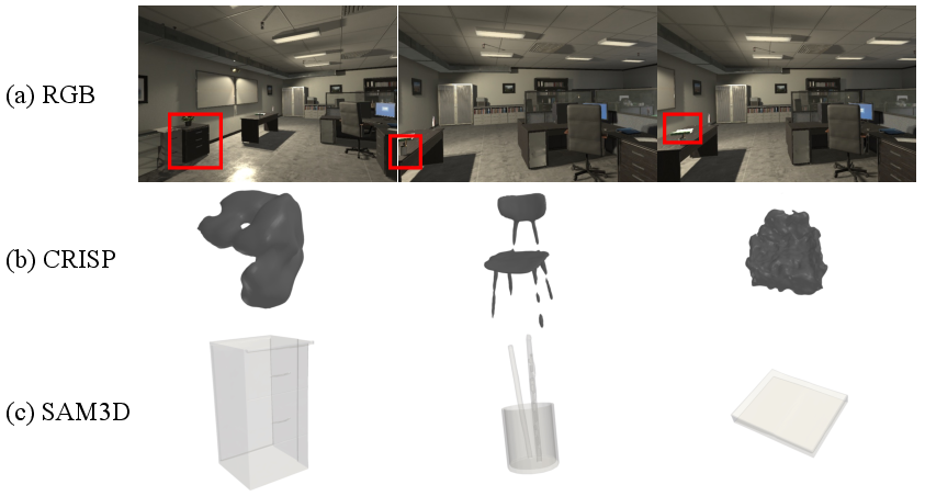
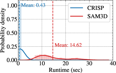
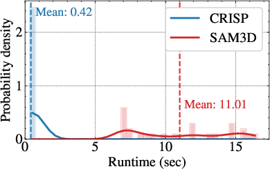
- SAM3D: a stronger foundation model that can generalize to new, unseen object types, but it’s slower. It gives a detailed mesh and pose, then Hydra++ estimates the real-world scale by comparing the predicted depth to sensor depth.
Analogy: If you only see the front of a chair, these models “imagine” the whole chair in 3D based on what they know about shapes.
2) Reprojection-Mask Consistency Check (RMCC) (a double-check)
- Sometimes the shape model can be fooled by a bad or partial mask and produce the wrong shape.
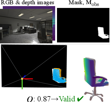
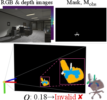
- RMCC checks the prediction by “projecting” the 3D shape back into the camera image and measuring how well it lines up with the original object mask.
- If the overlap is too low, Hydra++ rejects that shape.
Analogy: It’s like sketching a 3D object, taking a photo of your sketch from the same angle, and making sure it matches the outline in the original photo.
3) Hybrid LiDAR–camera mapping with a ground-aware fix
- Outdoors, depth cameras often struggle, and LiDAR points can be sparse and come in at shallow angles—especially for the ground—causing holes or broken surfaces in the map.
- Hydra++ combines LiDAR (for precise distances) with images (for object masks and shapes).
- It also uses a “ground-aware adaptive integration” trick: it slightly widens the allowed range when updating ground voxels so the system doesn’t miss the ground surface. This reduces holes and makes the ground mesh more complete.
Analogy: Imagine painting a road line with a brush. If you only paint exactly where you touch, you might leave gaps. Widening the stroke a bit helps you get a continuous line.
What did they find?
The researchers tested Hydra++ in both a realistic simulator (indoor scenes) and on a campus (outdoor scenes). Here’s what they observed:
- Better object shapes, not just boxes:
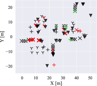
- Compared to systems that store only partial point clouds or simple bounding boxes, Hydra++ reconstructs complete meshes for each object.
- This is especially helpful when objects in the same category look different (e.g., different kinds of chairs or bins). Template-based systems struggle here; Hydra++ adapts to each instance.
- More reliable results with RMCC:
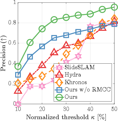
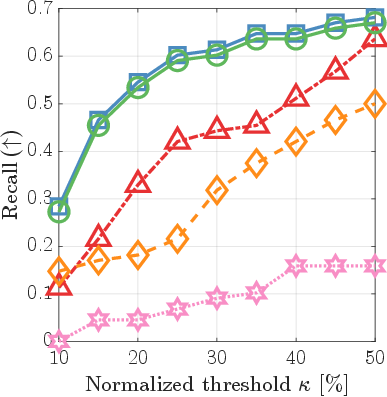
- The reprojection check filters out bad predictions that come from messy masks or occlusions.
- Precision (how many accepted shapes are actually correct) improves, so the scene graph objects are more trustworthy.
- Outdoor improvements with hybrid sensing:
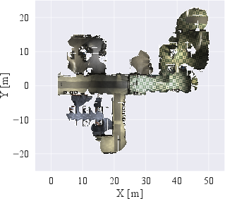
- The LiDAR–camera combo plus the ground-aware integration produces cleaner, more continuous ground and background meshes.
- At the same time, the object shapes are detailed because the image-based model fills in missing geometry.
- Speed vs. generalization trade-off:
- CRISP runs fast enough for real-time updates and works well on known object types.
- SAM3D handles unfamiliar objects better but takes seconds per object—too slow for real-time multi-object mapping. Hydra++ can use either, depending on needs.
Why does this matter?
- Smarter robots: Detailed, accurate object shapes let robots do more than just avoid obstacles—they can plan grasps, reason about support and contact, and manipulate or rearrange objects safely.
- Robust in the real world: The hybrid sensor setup and ground-aware fix make large-scale outdoor mapping more reliable, which matters for delivery robots, autonomous vehicles, and inspection.
- Flexible system: Because Hydra++ is modular, future shape models can be plugged in as they improve, balancing speed and generalization as needed.
In short, Hydra++ takes 3D scene graphs a step further by giving robots both the “what” and the “exact shape” of things around them, and it does this fast enough to be useful in real-time applications.
Knowledge Gaps
Unresolved limitations, knowledge gaps, and open questions
Below is a consolidated list of concrete gaps and open questions that remain after this work and that could guide follow-up research.
- Multi-view shape estimation: the system selects a single “most visible” frame for each object; it does not aggregate multi-view cues for joint pose/shape refinement. How much would multi-view optimization (e.g., across all frames in a track) reduce reconstruction error and RMCC rejections?
- Loop-closure consistency: object pose and mesh are anchored to the camera pose at selection time t*. The paper does not detail how meshes are updated after global trajectory corrections (loop closures/deformations). How should object meshes and their poses be consistently re-aligned with scene updates?
- Dynamic and moving objects: evaluation focuses on static scenes; handling of moving objects (pose/shape over time, trajectory-linked meshes, replacement vs update policies) is not addressed. What representations and policies are needed for transient or articulated objects?
- RMCC design limitations: RMCC relies on 2D mask overlap only. It does not account for occlusion reasoning, depth agreement, or silhouette ambiguity. Would adding depth-consistency residuals, z-buffer–aware occlusion handling, or multi-view reprojection checks reduce false accepts/rejects?
- RMCC thresholding and calibration: the choice of overlap threshold τO and its sensitivity are not studied. Is there a principled, data-driven way (e.g., learned calibration or uncertainty-driven thresholds) to set τO across object classes, ranges, and sensors?
- Fallback strategy after RMCC rejection: the system rejects degenerate predictions, but the downstream representation of those objects (e.g., partial mesh, bbox proxy, or deferred re-estimation) is not specified. What fallback preserves scene-graph utility without introducing persistent false negatives?
- SAM3D scale recovery: metric scale is estimated via median depth ratios from a single view; the accuracy, robustness to depth noise, and failure modes are not quantified. Would multi-view scale estimation or robust regression improve SAM3D alignment?
- Handling segmentation errors: shape estimation and RMCC depend on off-the-shelf instance masks, but segmentation quality and its impact are not quantified. Can joint segmentation-shape estimation or uncertainty-weighted RMCC reduce failure cascades from mask noise?
- Out-of-domain (OOD) generalization metrics: OOD robustness (e.g., “computer” class) is shown qualitatively but not evaluated quantitatively (Chamfer, V-IoU, pose/scale error). What standardized OOD benchmarks and metrics best capture generalization for object-level scene graphs?
- Dataset scale and annotation pipeline: real-world CRISP training used ~50 keyframes and manual mesh hole repairs. What data volume/quality is required for reliable deployment across categories and conditions? Can automatic mesh repair or synthetic data reduce manual burden?
- Generalization across sensors and domains: the impact of camera/LiDAR types, lighting, weather, and scene clutter on pose/shape accuracy is not explored. How robust is the pipeline to severe domain shifts, and what adaptation strategies (fine-tuning, self-training) are most effective?
- Computational scalability: end-to-end throughput, GPU/CPU/memory use, and performance under many simultaneous objects/tracks are not reported. What scheduling, batching, or asynchronous refinement strategies sustain real-time operation at scale?
- Shape estimator uncertainty: neither CRISP nor SAM3D expose calibrated uncertainty that could inform RMCC and graph decisions. Can learned uncertainty (e.g., aleatoric/epistemic) be integrated to drive acceptance thresholds, active re-observation, or deferral?
- Multi-robot settings: the system is not evaluated in collaborative/multi-robot contexts (communication limits, consensus on shapes, conflict resolution). How should object meshes and graph edges be fused and synchronized across agents?
- Scene-graph relational accuracy: the benefits of higher-fidelity object meshes on edge inference (support, adjacency, inclusion) are not quantified. Do better shapes measurably improve relational correctness and downstream reasoning?
- Impact on downstream tasks: claims about manipulation/rearrangement benefits are not supported by task-level evaluations. How do improved object meshes affect grasp planning, collision checking, or language-grounded queries in the loop?
- Hybrid LiDAR-camera calibration: accuracy is sensitive to time sync and extrinsic calibration, but robustness and re-calibration strategies are not discussed. How do calibration errors propagate to shape/pose estimates and RMCC outcomes?
- Ground-aware TSDF parameters: the extended negative support (d_extra ≈ 3 m) is set empirically; parameter sensitivity, failure cases (e.g., near curbs/ramps), and effects on non-ground surfaces are not analyzed. Can angle/range-adaptive or learned policies reduce artifacts?
- Background reconstruction beyond ground: improvements focus on the ground plane; benefits for vertical/complex structures at oblique incidence are not evaluated. Does the adaptive integration strategy generalize beyond ground labels?
- Association in crowded scenes: max-IoU voxel association may struggle with nearby, similar instances; robustness and failure handling for track switching/merging are not assessed. Are stronger 2D–3D association metrics or identity features needed?
- Pose and scale metrics: while centroid-based detection and Chamfer/IoU are reported, explicit 6-DoF pose error and scale error distributions are not. How accurate are rotations/translations/scales across object types and ranges?
- Handling category ambiguity and open-vocabulary labels: the pipeline assumes per-pixel category labels; open-vocabulary mapping and category uncertainty are not integrated. How can LLMs or vision-language features improve category assignment for shape estimators?
- Articulated/deformable objects: methods assume rigid, single-part shapes. What extensions are needed for articulated or deformable objects and to represent configuration-dependent geometry in the scene graph?
- Hyperparameter and ablation coverage: several key choices (τd, τO, voxel size, sample density for RMCC, mask selection policy) lack sensitivity analyses. Which settings most affect accuracy/efficiency, and can they be tuned online?
- Failure characterization and diagnostics: systematic analysis of failure modes (by class, range, occlusion level, lighting) is limited. A taxonomy and diagnostic suite would guide where to invest model capacity and sensing resources.
Practical Applications
Immediate Applications
Below are practical use cases that can be deployed with the paper’s current methods (CRISP-based real-time scene graph construction, RMCC filter, hybrid LiDAR–camera mapping, and ground-aware TSDF integration).
- High-fidelity mobile-robot mapping for navigation and manipulation
- Sectors: robotics, warehousing, service robots, smart buildings
- What it does: Builds hierarchical 3D scene graphs with instance-specific object meshes and spatial relations, improving path planning (continuous ground mesh) and safer navigation around object shapes vs coarse boxes.
- Tools/products/workflows: ROS2 node integrating Hydra++, active window TSDF mapping, RMCC screening for robust object nodes; plug-in to existing autonomy stacks (Nav2, MoveIt).
- Assumptions/dependencies: Accurate instance segmentation; calibrated and synchronized sensors; CRISP trained on relevant object categories; sufficient compute (GPU); reliable odometry.
- Contact-aware planning with better collision geometry
- Sectors: robotics, industrial automation
- What it does: Uses instance meshes instead of bounding boxes for more precise clearance checks, reachability analysis, and conservative collision buffers in tight spaces.
- Tools/products/workflows: Scene-graph-to-planner adapter that exports watertight object meshes to planners/simulators; RMCC-based quality control before planner ingestion.
- Assumptions/dependencies: Mesh timing (shapes estimated when tracks go inactive) aligns with planner update cadence; segmentation quality; robust extrinsics.
- Facility and campus asset inventory with geometric detail
- Sectors: facilities management, municipal services, utilities
- What it does: Semi-automatic inventory of fixed assets (e.g., hydrants, benches, bins) with metrically scaled meshes for maintenance, positioning, and change detection.
- Tools/products/workflows: Patrol UGV with hybrid LiDAR–camera; daily/weekly runs; export to GIS/BIM databases; RMCC as QA gate to flag unreliable reconstructions.
- Assumptions/dependencies: Permissions for data capture; mapping-to-asset registry alignment; outdoor-ready segmentation models.
- “As-found” digital twins with room/object hierarchy
- Sectors: construction tech, AEC, digital twins
- What it does: Generates room–place–object graphs with meshes for model handover and contextualized maintenance.
- Tools/products/workflows: Hydra++ export to IFC/BIM or USDZ; scene graph SDK; RMCC acceptance threshold setting; mesh decimation pipeline for twin platforms.
- Assumptions/dependencies: Semantic taxonomy mapping to BIM classes; SLAM drift bounds; sensor coverage of each space.
- AR/VR content capture with instance meshes
- Sectors: media, gaming, interior design
- What it does: Produces object-level meshes suitable for AR placement and occlusion, enabling more realistic AR previews and level design.
- Tools/products/workflows: Capture on robot or handheld RGB-D/iPad LiDAR; mesh export (glTF/OBJ); basic scene graph viewer.
- Assumptions/dependencies: Acceptable latency (CRISP real-time); good lighting; segmentation that generalizes to the environment.
- Outdoor ground-surface mapping for safer UGV navigation
- Sectors: logistics yards, construction, agriculture
- What it does: Ground-aware adaptive TSDF improves ground continuity at long range/incidence angles, reducing false holes/steps in traversability maps.
- Tools/products/workflows: Hybrid LiDAR–camera mode; incorporation into costmap generation; QA overlays highlighting sign-transition coverage.
- Assumptions/dependencies: Ground labeling (e.g., Patchwork) available; LiDAR–camera calibrations; stable mounting to limit vibration.
- QA filtering for learned 3D predictions via RMCC
- Sectors: robotics perception, 3D vision pipelines
- What it does: Reprojection–mask consistency check acts as a generic safety filter to reject degenerate object shapes from partial/incorrect masks.
- Tools/products/workflows: RMCC library reusable in other SDF/mesh predictors; dashboard displaying overlap scores/histograms; auto-retry heuristics (e.g., defer estimation until a better view).
- Assumptions/dependencies: Accurate intrinsics/extrinsics; well-chosen overlap threshold; visibility-aware sampling of the predicted mesh.
- Academic benchmarking of estimator–latency trade-offs
- Sectors: academia, R&D labs
- What it does: Provides a system-level harness to compare CRISP (real-time) vs SAM3D (strong OOD generalization but slow) in realistic pipelines.
- Tools/products/workflows: Hydra++ evaluation scripts; data logging for run-time distributions; ablations with/without RMCC; indoor (uHumans2) and outdoor (Kimera-Multi) setups.
- Assumptions/dependencies: Access to both models; reproducible training for CRISP with category-specific data; standardized metrics (Chamfer, B-IoU, V-IoU).
- Change detection for maintenance and safety
- Sectors: facilities, logistics, manufacturing
- What it does: Compare meshes over time to flag displaced or deformed objects (e.g., new obstacles, damaged street furniture).
- Tools/products/workflows: Periodic patrols; per-object mesh differencing and centroid drift checks; scene-graph-based alerts.
- Assumptions/dependencies: Consistent robot routes; stable localization across sessions; controlled false alarms due to segmentation drift.
- Robotics education and prototyping
- Sectors: education, makerspaces
- What it does: A turnkey perception stack demonstrating modern scene graphs, learned shape inference, and hybrid sensing outdoors.
- Tools/products/workflows: Course labs using Hydra++; visualization tools; packaged datasets; simple assignments on RMCC thresholds and hybrid integration.
- Assumptions/dependencies: Student access to RGB-D or low-cost LiDAR + camera; GPU availability.
Long-Term Applications
These scenarios benefit from the paper’s innovations but require additional research, scaling, or productization (e.g., accelerating SAM3D-like models, improving segmentation robustness, or enabling multi-agent scale).
- Contact-rich manipulation and rearrangement with instance-specific physics
- Sectors: household robotics, manufacturing
- What it could do: Use accurate meshes for grasp synthesis, stable placements, and contact simulation to reduce failure rates in cluttered, diverse objects.
- Tools/products/workflows: Tight loop between scene graph, grasp planner, and controller; learned affordances; on-the-fly mesh refinement during interaction.
- Assumptions/dependencies: Faster or incremental shape refinement while tracks are active (not only when inactive); high-quality masks at contact time; robust pose tracking.
- City-scale semantic digital twins and curb management
- Sectors: smart cities, transportation, urban planning
- What it could do: Multi-robot mapping of streetscapes with asset-level meshes (signs, hydrants, benches) for curb-use policy, accessibility auditing, and maintenance scheduling.
- Tools/products/workflows: Collaborative dynamic scene graphs; cloud-based fusion; IFC/GIS integration; policy analytics dashboards.
- Assumptions/dependencies: Scalable backends; bandwidth/edge compute; privacy protections; standardized taxonomies; regulatory approvals.
- Autonomous driving HD semantic mapping with object meshes
- Sectors: automotive, AV infrastructure
- What it could do: Enrich HD maps with robust ground surfaces and metrically-scaled object meshes for improved localization, prediction, and occlusion reasoning.
- Tools/products/workflows: AV perception stack plugin; continuous map maintenance; mesh-to-sensor residual checks.
- Assumptions/dependencies: OOD robustness (foundation models) at real-time speeds; stringent safety certification; extreme weather handling.
- Retail and warehouse inventory digitalization at scale
- Sectors: retail, logistics
- What it could do: Whole-store scene graphs with per-item meshes to automate planogram checks, restock prioritization, and aisle safety validation.
- Tools/products/workflows: Store robots; SKU-to-semantic mapping; ERP connectors; exception workflows.
- Assumptions/dependencies: Very robust segmentation (crowded, reflective packaging); fast OOD shape inference; privacy compliance.
- Construction progress monitoring and BIM conformance
- Sectors: construction, AEC
- What it could do: Compare as-built meshes to BIM models at object-level granularity (fixtures, furniture) to detect deviations and support punch lists.
- Tools/products/workflows: Site robots/drones; BIM alignment tools; clash detection using meshes rather than coarse boxes.
- Assumptions/dependencies: High tolerance for dust/occlusion; broad category coverage; accurate global alignment and loop-closure management.
- Search-and-rescue and disaster assessment
- Sectors: public safety, defense
- What it could do: Rapid scene-graph mapping with object meshes under occlusion and debris, aiding path planning and triage.
- Tools/products/workflows: Rugged sensors; on-device RMCC as hard filter; human-in-the-loop verification.
- Assumptions/dependencies: Strong OOD generalization at low latency; degraded sensing operation; intermittent GNSS and comms.
- Language-driven robot assistance grounded in instance meshes
- Sectors: assistive robotics, HRI
- What it could do: Combine scene graphs and LLMs to follow natural-language instructions that hinge on object geometry (e.g., “pick up the chair with armrests near the window”).
- Tools/products/workflows: Scene graph–LLM bridge; referring expression grounding; affordance reasoning tied to mesh attributes.
- Assumptions/dependencies: Reliable intra-class shape distinctions; robust language grounding; safety mitigations for ambiguous cases.
- Generative simulation and synthetic data engines from real scans
- Sectors: simulation, gaming, vision AI
- What it could do: Use captured scene graphs with meshes to bootstrap simulation worlds for training and testing embodied AI, including realistic occlusions and contacts.
- Tools/products/workflows: Export pipelines to simulators (Isaac Sim, Unreal); procedural variation around real layouts.
- Assumptions/dependencies: Licensing/consent for captured spaces; mesh cleanup at scale; domain gap management.
- On-device, privacy-preserving mapping appliances
- Sectors: smart homes, enterprise facilities
- What it could do: Run Hydra++ locally to create utility maps for robots without cloud uploads, retaining only anonymous meshes and graph structure.
- Tools/products/workflows: Edge-optimized CRISP-like models; encrypted storage; selective redaction of sensitive classes.
- Assumptions/dependencies: Efficient inference on embedded GPUs/NPUs; robust OTA updates; policy-compliant data lifecycle.
- Agriculture and environmental monitoring
- Sectors: agtech, environmental science
- What it could do: Reconstruct plant/trellis geometries and field assets to measure growth and plan interventions.
- Tools/products/workflows: Outdoor-hardened hybrid mapping; seasonal change detection; agronomic analytics.
- Assumptions/dependencies: Generalization to organic shapes; severe lighting/weather; specialized segmentation models.
Cross-cutting assumptions and dependencies that impact feasibility
- Segmentation quality: Both CRISP and RMCC depend on reasonably precise instance masks; performance degrades with heavy over/under-segmentation.
- Model coverage vs generalization: CRISP requires training on in-domain categories for real-time use; SAM3D generalizes better but is too slow for online multi-object use unless accelerated.
- Sensor calibration and synchronization: Accurate intrinsics/extrinsics, timing, and ground labeling (for adaptive integration) are critical, particularly in hybrid LiDAR–camera mode.
- Compute constraints: Real-time claims assume GPU availability and CRISP-based inference; embedded deployment requires model optimization.
- Operational cadence: In the current pipeline, mesh estimation is triggered when a track becomes inactive; applications needing immediate meshes may require pipeline changes (e.g., mid-track estimation).
- Environment factors: Outdoor glare, rain, dust, and sparse depth returns stress both mapping and segmentation; hybrid sensing mitigates but does not eliminate these issues.
- Data governance: For facility/city use, privacy, consent, and regulatory compliance (e.g., sensitive spaces) are necessary.
- Standardization and interoperability: Export to BIM/IFC/GIS and integration with existing robotics middleware and digital-twin platforms require stable schemas and APIs.
Glossary
- 3D scene graph: A structured representation of a 3D environment where entities are nodes and spatial/semantic relations are edges. "3D scene graphs provide a hierarchical abstraction of environments by encoding spatial entities (e.g. objects, places) and their relationships."
- 6-DoF pose: A pose representation with six degrees of freedom (3 for position, 3 for orientation). "the system invokes a learning-based shape estimation module for 6-DoF pose and shape estimation"
- Active window module: A moving spatial region where data is integrated online to maintain a current map. "an active window module maintains a volumetric map~ that is incrementally updated via projective truncated signed distance field~(TSDF) integration"
- Axis-aligned bounding boxes (AABBs): Bounding boxes whose faces are parallel to the coordinate axes, used for coarse object geometry. "Intersection-over-union of the 3D axis-aligned bounding boxes of the matched objects:"
- Back-projection: Mapping image pixels with depth back into 3D space using camera intrinsics. "each lifted to 3D by back-projecting the depth image through the camera intrinsics and depth information into a vertex map~."
- Bounding-Box IoU (B-IoU): Intersection-over-union computed between axis-aligned 3D bounding boxes. "Bounding-Box IoU (B-IoU): Intersection-over-union of the 3D axis-aligned bounding boxes of the matched objects:"
- Camera frustum: The pyramidal volume representing the camera’s field of view. "the camera frustum visualizing the observed mask alongside the reprojected mask "
- Camera intrinsics: Parameters defining the camera’s internal geometry (focal lengths, principal point). "back-projecting the depth image through the camera intrinsics"
- Category-agnostic shape estimation: Shape prediction without relying on category-specific priors. "Hydra++ incorporates category-agnostic shape estimation"
- Centroid-based metrics: Evaluation metrics that compare object centers for detection accuracy. "For detection, we use centroid-based metrics."
- Chamfer Distance: A bidirectional point-set distance metric for geometric similarity. "Chamfer Distance: Bidirectional point-to-point distance between point sets and "
- Deformation-graph-based optimization: Mesh/map adjustment using a graph of local deformations for consistency. "which are then optimized and updated asynchronously by the backend through deformation-graph-based optimization and incremental updates"
- DINOv2 backbone: A pre-trained vision transformer used as the feature extractor in the network. "It employs a DINOv2 backbone~\cite{Oquab23arxiv-dinov2} with parallel branches for shape reconstruction and NOCS prediction"
- Factor graph formulations: Graph-based probabilistic models where variables and factors represent SLAM constraints. "model objects using parametric geometric primitives within factor graph formulations"
- Ground-aware adaptive integration strategy: A TSDF integration tweak that improves ground surface reconstruction under sparse, oblique measurements. "To address this, we introduce a ground-aware adaptive integration strategy."
- Hybrid LiDAR-camera configuration: A sensing setup that combines LiDAR depth with camera imagery. "Hydra++ supports a hybrid LiDAR-camera configuration for large-scale operation"
- Implicit SDF decoder: A neural decoder that represents shapes as an implicit signed distance function. "The object mesh is then obtained by decoding through an implicit SDF decoder"
- Intra-class variation: Differences in shape among objects within the same semantic class. "The object shape estimation network in our framework captures intra-class variation"
- Instance segmentation: Per-pixel labeling that distinguishes individual object instances. "the system receives sensor data (RGB-D or LiDAR + RGB/RGB-D camera), instance segmentation masks, and odometry estimates."
- Intersection-over-union (IoU): A ratio measuring overlap between two regions or volumes. "Intersection-over-union of the 3D axis-aligned bounding boxes of the matched objects:"
- Iso-surface: The surface representing a constant value (e.g., zero level-set) of a scalar field like SDF/TSDF. "extracting the iso-surface via marching cubes"
- Latent shape code: A compact vector representation encoding an object’s shape. "where $}^C$ is the object pose relative to the NOCS canonical frame, is the metric scale, and is the latent shape code."
- Loop closures: Recognitions of previously visited places used to correct accumulated drift in maps. "handling loop closures through hierarchical descriptors and deformation-based optimization."
- Marching cubes: An algorithm for extracting polygonal meshes from scalar fields like TSDFs/SDFs. "via marching cubes"
- Max-IoU tracker: A tracker that associates detections across frames by maximizing intersection-over-union overlap. "A max- tracker~\cite{Schmid24rss-khronos} then associates clusters across frames using voxel-based overlap"
- Metric scale: The real-world scale factor that converts normalized or relative geometry to metric units. "The module outputs an object pose $}^C\in\mathrm{SE}(3)$, a metric scale , and an object mesh ."
- Metric-semantic 3D mesh: A mesh encoding both metric geometry and semantic labels. "performs metric-semantic 3D mesh construction and object tracking."
- NOCS (Normalized Object Coordinate Space): A canonical coordinate system used for consistent object pose/shape estimation across instances. "CRISP \cite{Shi25cvpr-CRISP} is a category-agnostic network that jointly estimates object mesh shape and 6-DoF pose and metric scale via normalized object coordinate space (NOCS) prediction."
- Neural SDF: A neural signed distance function that implicitly represents geometry. "a coarse ellipsoid and a fine-grained neural SDF"
- Odometry estimates: Estimates of the sensor/robot motion over time. "the system receives sensor data ..., instance segmentation masks, and odometry estimates."
- Open-vocabulary vision-language features: Visual features aligned with language embeddings enabling flexible semantic queries. "incorporating open-vocabulary vision-language features"
- Out-of-domain generalization: A model’s ability to handle inputs unlike its training distribution. "trade-off between out-of-domain generalization and inference latency."
- Panoptic LiDAR data: LiDAR measurements with both semantic and instance labels. "constructing collaborative dynamic scene graphs from multi-agent panoptic LiDAR data"
- Parametric geometric primitives: Simple shapes (e.g., quadrics, cuboids) parameterized and used to model objects. "model objects using parametric geometric primitives within factor graph formulations"
- Projective integration: TSDF update along the sensor ray direction instead of the surface normal. "In projective integration, the signed distance is estimated along the ray rather than the surface normal"
- Projective TSDF integration: Integrating depth into a truncated signed distance field using projective updates. "incrementally updated via projective truncated signed distance field~(TSDF) integration"
- Rasterizing: Rendering a mesh to an image/depth map from a given viewpoint. "by rasterizing from the camera viewpoint"
- Reprojection-mask consistency check (RMCC): A validation step comparing the mask rendered from the predicted shape against the observed mask. "a reprojection-mask consistency check (RMCC) to validate the prediction"
- SE(3): The Lie group of 3D rigid body motions (rotations and translations). "The module outputs an object pose $}^C\in\mathrm{SE}(3)$"
- Shape priors: Prior knowledge about plausible object shapes used to regularize reconstruction. "the integration of shape priors for detailed object representations has been explored"
- Signed distance field (SDF): A scalar field giving the signed distance to the nearest surface; zero at the surface. "CRISP relies on a well-defined signed distance field"
- Truncation band: The finite region around surfaces within which TSDF updates are integrated. "beyond the truncation band"
- V-IoU (Volumetric IoU): Intersection-over-union computed between voxelized 3D occupancies. "Volumetric IoU (V-IoU): Intersection-over-union between voxelized occupancies of the matched meshes"
- Vertex map: A 2D array storing 3D points back-projected from depth for each pixel. "into a vertex map~"
- Voxel: A volumetric pixel; the basic element of a 3D grid storing TSDF values. "voxels behind the ground surface receive integration updates"
- Voxel-based overlap: Overlap measure computed over voxels to associate objects across frames. "associates clusters across frames using voxel-based overlap"
- Volumetric map: A 3D grid map (e.g., TSDF) representing space and surfaces volumetrically. "an active window module maintains a volumetric map~"
Collections
Sign up for free to add this paper to one or more collections.