- The paper presents a radar-inertial odometry technique that compensates for extreme pitch and roll dynamics in subarctic environments.
- It integrates high-frequency IMU data with tilt-aware submap retrieval and vertical filtering to enhance motion compensation and point cloud registration.
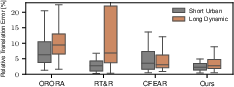
- Experimental results on the FoMo dataset show a median RTE of 2.8%, outperforming other state-of-the-art radar odometry methods under challenging terrain conditions.
Radar Odometry Under High Tilt Dynamics in Subarctic Terrains
Introduction and Motivation
The paper "Radar Odometry Subject to High Tilt Dynamics of Subarctic Environments" (2604.19962) systematically investigates the robustness and adaptability of rotating Frequency Modulated Continuous Wave (FMCW) radar odometry under the severe tilt dynamics encountered in subarctic environments. Traditional radar odometry pipelines are generally evaluated in milder, urban or industrial settings where pitch and roll remain limited. The authors address the gap by exposing contemporary radar odometry methods to abrupt terrain-induced motion, including pitch changes of up to 30∘ and roll up to 8∘, as well as substantial inter-scan tilt discontinuities. The core claim is the introduction of a radar-inertial odometry technique that, via tilt-proximity-based submap association and vertical displacement filtering, delivers superior robustness and accuracy under such non-ideal, dynamic conditions.
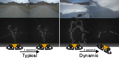
Figure 1: Typical rotating FMCW radar solutions are contrasted between flat and high-dynamic terrains, highlighting the severity of tilt changes in the latter.
Methodology
The proposed approach extends classical point-based radar odometry with two key innovations, leveraging inertial measurements for tilt compensation at multiple stages of the pipeline. The methodology comprises:
Experimental Setup
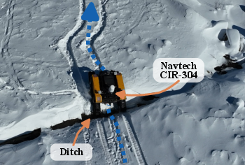
The evaluation leverages the FoMo dataset, collected in the subarctic region of Quebec, using a Navtech CIR-304 radar and VectorNav VN-100 IMU mounted on a Clearpath Warthog UGV. The dataset is uniquely challenging, covering a 300 m urban loop (Red) and a 2 km dynamic trajectory (Orange) that includes a stone quarry, steep ditches, and lateral slip in conditions with snow banks up to 1 m high.
The proposed method is benchmarked against three state-of-the-art radar odometry algorithms:
Results and Analysis
The main evaluation metrics include Relative Translation Error (RTE) and qualitative trajectory plots. The results demonstrate:
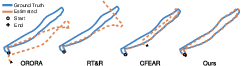
Visual inspection of estimated trajectories in the most demanding runs shows:
A close-up analysis in a quarry section exposes the limits of FMCW radar odometry when compounded by high lateral slip and abrupt slope transitions; all methods display increased high-frequency pose noise and occasional discontinuous jumps, emphasizing an inherent limitation in discrete radar feature-based registration under extreme terrain-induced motions.
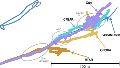
Figure 6: Detailed trajectory view in a stone quarry segment; while all methods show artifacts, the proposed approach displays less gross deviation and better heading stability through the ditch and incline.
Implications and Future Directions
The findings underscore the essential value of tightly fusing inertial and radar data for odometry in non-planar, non-urban domains, such as mining, forestry, and remote inspection. The tilt-aware submap selection and per-point vertical filtering are shown to be effective countermeasures against feature misassociation and orientation drift in the presence of severe pitch/roll. These techniques may generalize to other forms of sparse sensor registration in robotics.
Key practical implications include improved navigation reliability for UGVs operating in northern and off-road zones, where vision and lidar experience degraded performance. However, the residual high-frequency noise and pose discontinuities necessitate further research, possibly involving smoothing, learned priors, or hybrid dense-sparse strategies. The authors propose future integration of translational priors and benchmarking against dense radar methods; validation on large-scale urban datasets could further test the limits of the architecture.
Conclusion
This study delivers a comprehensive, well-controlled comparative analysis of radar odometry under the extreme dynamics of subarctic terrains and introduces a radar-inertial odometry framework that defines a new robustness frontier for FMCW radar-based localization. The results have practical relevance for autonomous navigation in highly dynamic and unstructured environments, with fertile potential for extensions into denser radar registration paradigms and robust smoothing for high-frequency motion artifacts.