- The paper introduces SCC-Loc, a unified framework that integrates semantic alignment, cascaded filtering, and consensus-driven optimization for UAV thermal geo-localization in GNSS-denied scenarios.
- It employs a shared DINOv2 backbone with innovative SGVA, C-SATSF, and CD-RAPS modules to effectively bridge the modal gap between thermal and visible imagery.
- The approach achieves a mean localization error of 9.37 m and demonstrates robust performance across varied lighting conditions using the comprehensive Thermal-UAV dataset.
SCC-Loc: Unified Semantic Cascade Consensus Framework for UAV Thermal Geo-Localization
Robust GNSS-denied UAV navigation mandates precise geo-localization under variable lighting and environmental conditions. Conventional visual geo-localization methods suffer catastrophic degradation in low-light and nighttime scenarios due to reliance on photometric consistency. Thermal geo-localization leverages illumination-invariant thermal infrared imagery, providing resilience against severe environmental disruptions. However, the fundamental modality gap between thermal and visible imagery leads to severe feature ambiguity, spatial quantization bias, and proliferation of structural outliers, which corrupt traditional coarse-to-fine pipelines.
Existing methods, including supervised thermal-specific networks, are reliant on bulky domain-specific training and constrained to narrow environmental conditions, thereby lacking zero-shot generalizability. Compounding this challenge is data scarcity, especially the absence of diverse cross-modal datasets with comprehensive spatial and temporal coverage. The paper introduces SCC-Loc: a unified framework that systematically dismantles these bottlenecks through advanced semantic alignment, cascaded filtering, and consensus-driven optimization, coupled with the construction of the Thermal-UAV dataset—currently the most comprehensive benchmark in the field.
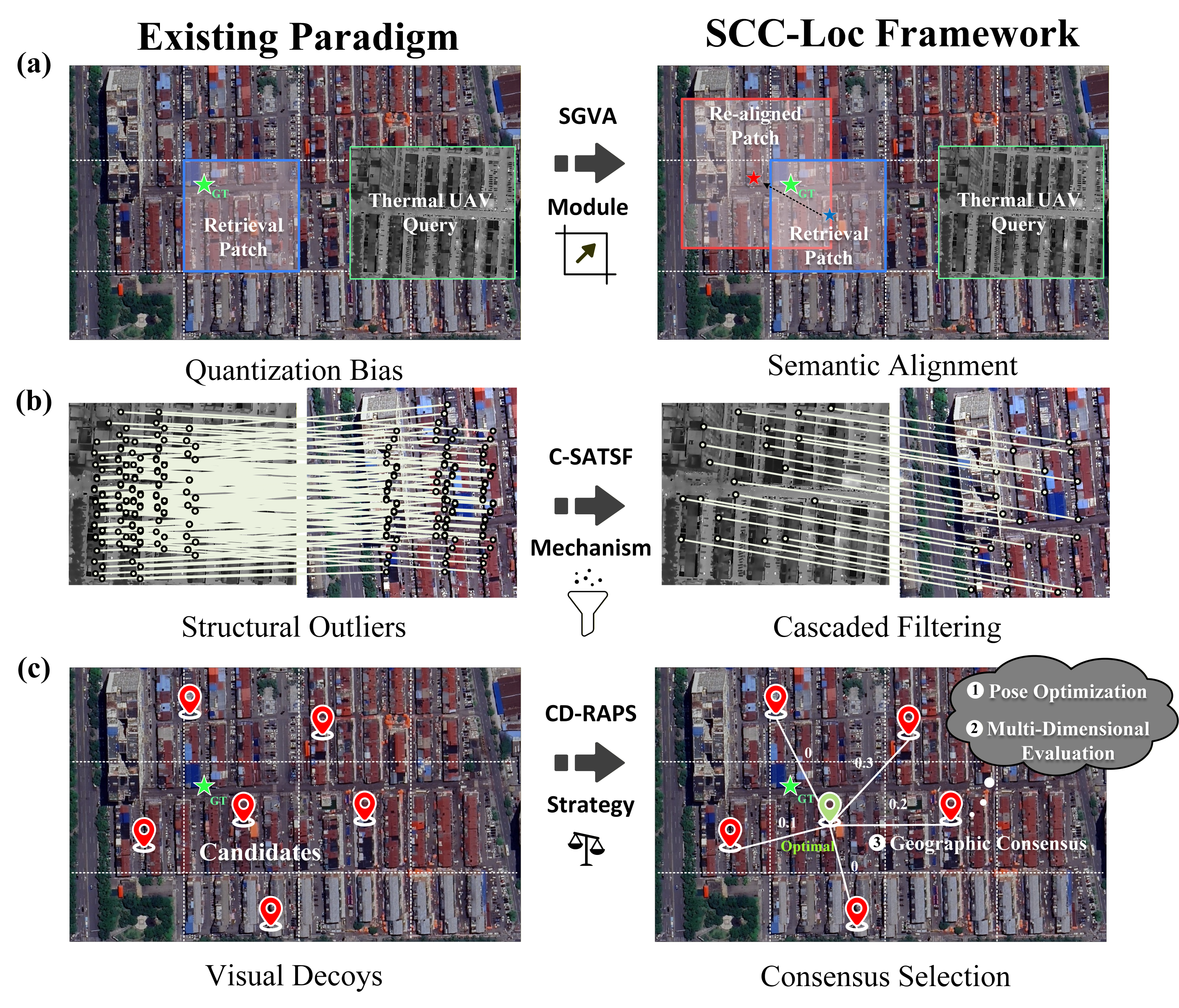
Figure 1: Conceptual comparison illustrating SCC-Loc’s threefold resolution of modality-induced localization challenges — semantic alignment corrects spatial bias, cascaded filtering purges structural outliers, and consensus selection eliminates visual decoys.
SCC-Loc Framework Architecture
SCC-Loc employs a cohesive coarse-to-fine paradigm utilizing a shared DINOv2 backbone for both retrieval and matching, minimizing memory footprint and enabling seamless cross-modal feature bridging. The pipeline entails:
- Feature Extraction: Dense spatial features and global tokens are extracted using DINOv2, aligning thermal-visible representations.
- SGVA Module: Semantic-Guided Viewport Alignment leverages the UAV’s global token to adaptively crop satellite candidate patches, robustly correcting the spatial quantization bias introduced by grid-based database construction.
- C-SATSF Mechanism: Cascaded Spatial-Adaptive Texture-Structure Filtering applies spatial equalization, adaptive texture saliency gating, and structure-consistent geometric refinement to iteratively strip away dense cross-modal outliers, distilling a reliable correspondence set.
- CD-RAPS Strategy: Consensus-Driven Reliability-Aware Position Selection integrates physically constrained non-linear pose optimization, multi-dimensional reliability metrics, and geographic consensus voting to select the robust optimal hypothesis, suppressing visual decoy-induced drift.
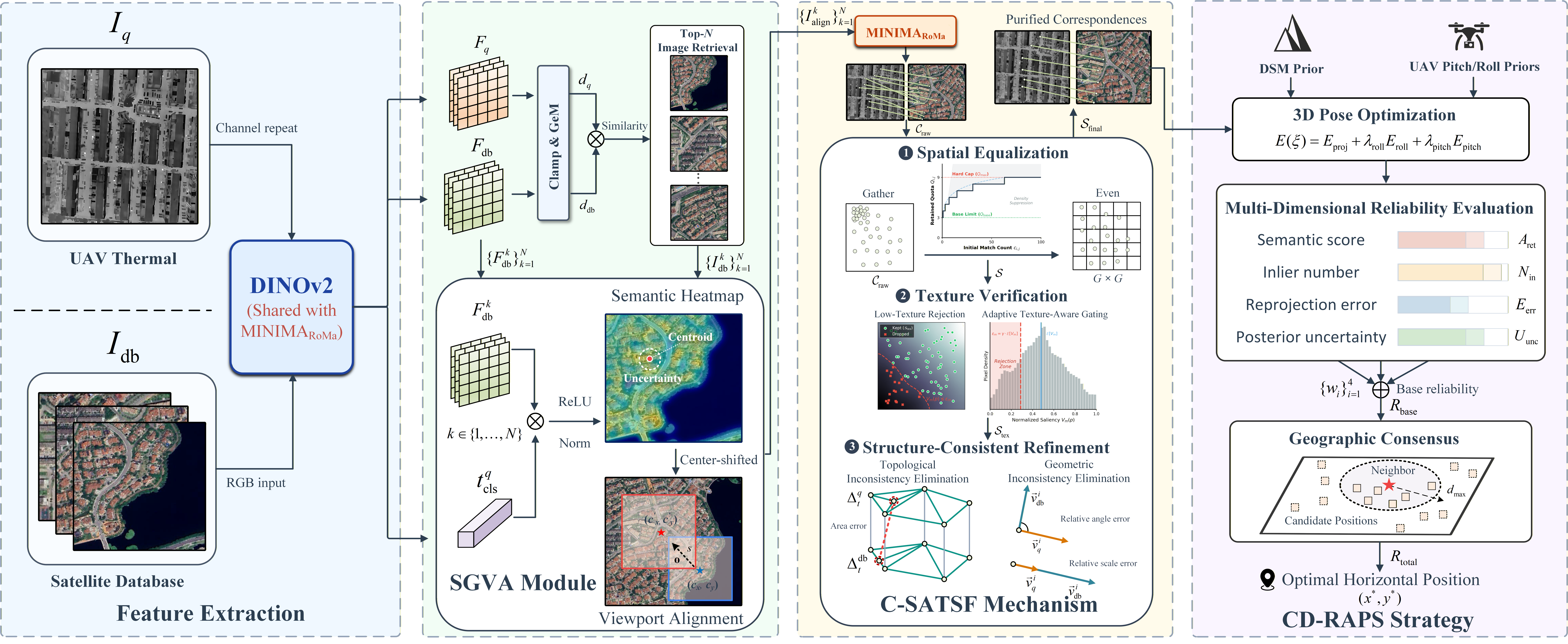
Figure 2: SCC-Loc pipeline overview showing feature extraction, semantic viewport alignment, cascaded filtering, and consensus-driven selection for precision UAV localization.
Dataset Construction and Benchmarking
Thermal-UAV is a large-scale benchmark comprising 11,890 thermal images across urban and rural scenes, with systematic capture of diurnal variations and profound modality discrepancies. It includes geographically aligned satellite maps and DSMs, facilitating 3D-aware localization and rigorous evaluation across daytime and nighttime regimes.
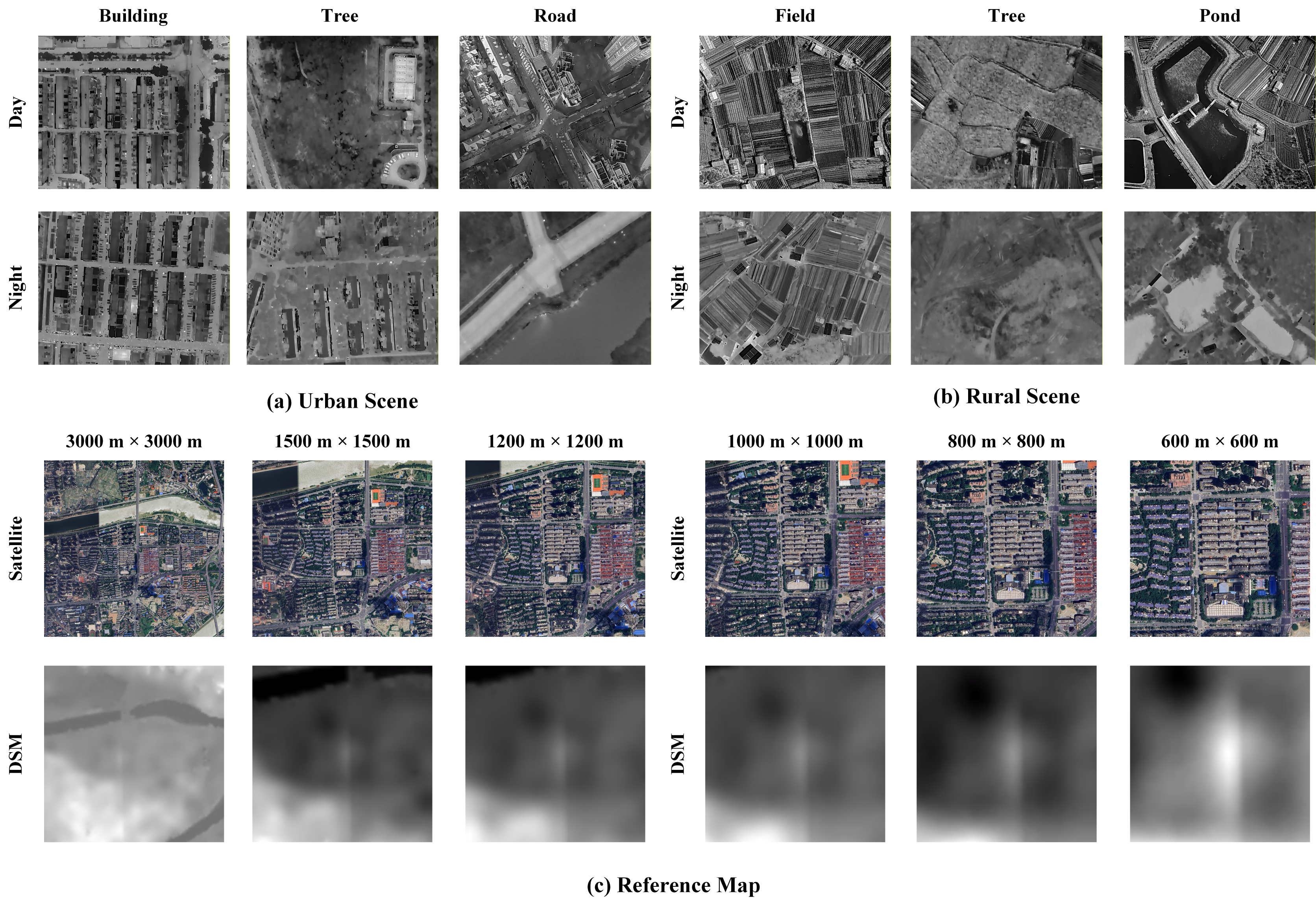
Figure 3: Visual samples from the Thermal-UAV dataset, exhibiting urban/rural thermal queries and their corresponding visible-light satellite/DSM references.
Stagewise Operation and Visualization
The qualitative operation of SCC-Loc reveals the adaptive correction of spatial bias using SGVA, progressive elimination of structural outliers via C-SATSF, and robust decoy suppression through CD-RAPS consensus voting. Structural repetitions—such as identical rooftops or agricultural plots—previously yielded high inlier counts and localization drift. SCC-Loc’s synergistic integration renders these decoys ineffective, yielding high-confidence spatial clustering around the true geographic candidate and achieving precise localization in both urban and rural scenarios.
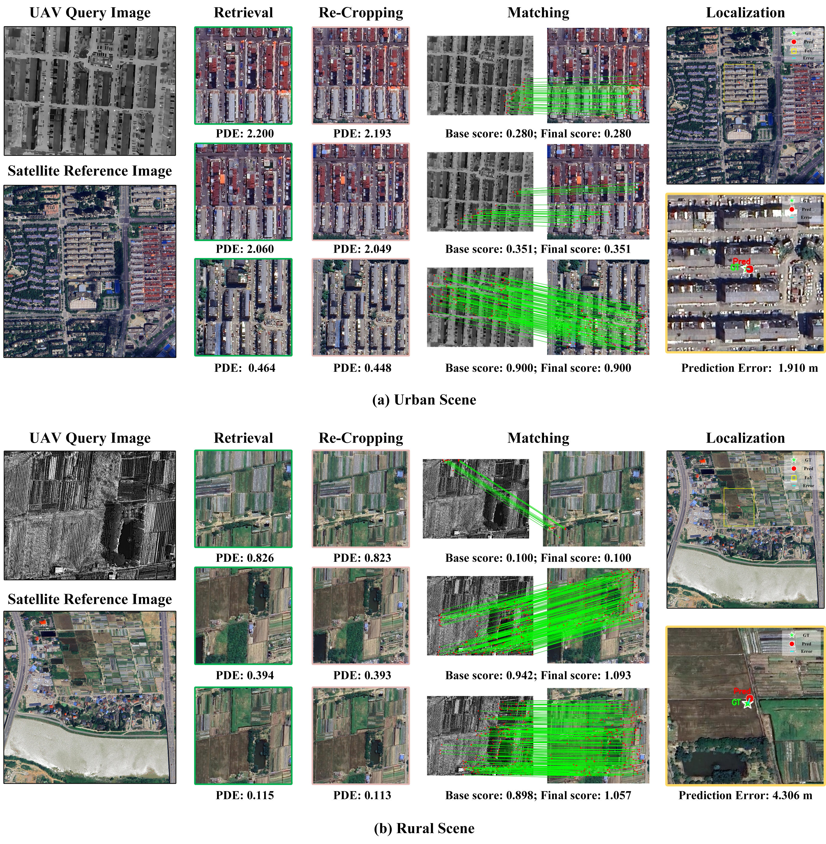
Figure 4: Visualization of SCC-Loc’s localization pipeline in urban/rural scenarios, demonstrating semantic viewport correction, structural filtering, and consensus-based hypothesis selection.
Quantitative Results and Comparative Analysis
SCC-Loc achieves a mean localization error of 9.37 m under strict Top-10 retrieval, outperforming the strongest baseline (DINOv2+MINIMA$_{\text{RoMa}$) by a factor of 7.6 at the 5-meter threshold. Domain-specific end-to-end networks (e.g., STHN, NIVnet) exhibit near-random performance in expanded search spaces due to susceptibility to visual decoys and lack of hierarchical search. SCC-Loc maintains robust accuracy and scalability as the search area increases, with mean errors significantly bounded compared to conventional approaches.
The ablation study confirms the critical contribution of consensus-driven selection (CD-RAPS), which provides the largest standalone gain in Acc@5 and error reduction. The synergy between cascaded filtering and consensus voting delivers a transformative leap in robustness and spatial precision. Semantic viewport alignment further enhances match quality by ensuring optimal spatial centering, substantially mitigating target marginalization inherent in grid-based retrieval.
Memory efficiency is achieved via backbone sharing, reducing peak GPU usage by half compared to disjointed pipelines, with only marginal latency tradeoff attributable to rigorous filtering and optimization.
Robustness Assessment
SCC-Loc exhibits high resilience to yaw disturbances due to rotational invariance in DINOv2-based features. Though pitch biases induce predictable degradation due to their dual role in scaling and pose optimization, SCC-Loc’s mean error remains bounded to under 30 meters even under extreme dual-noise configurations, substantially outperforming baselines under ideal conditions.
Implications and Future Directions
The paper demonstrates that cross-modal ambiguity is not merely photometric but structural—topological repetition can manifest as spatial illusion, deceiving matchers at the correspondence stage. SCC-Loc’s integration of geometric filtering and multi-dimensional reliability evaluation—grounded in physical UAV priors—breaks this illusion, providing robust discrimination between true and false geographic candidates.
Practical deployment obstacles remain: heavy hyperparameter dependency, telemetry sensitivity, and sequential computational overhead. Evolution toward an end-to-end trainable architecture with learnable parameters and implicit attitude compensation is suggested, which would amortize initialization complexity and enable real-time operation on edge devices.
Conclusion
SCC-Loc establishes a unified, memory-efficient framework for UAV thermal geo-localization, systematically resolving spatial, structural, and decoy-induced bottlenecks. The introduction of the Thermal-UAV dataset sets a new cross-modal benchmark, validating the viability of thermal imagery as a complementary modality for all-weather UAV navigation. SCC-Loc’s cohesive paradigm—combining semantic alignment, cascaded geometric filtering, and consensus-driven optimization—advances the state-of-the-art in multimodal remote sensing image registration and cross-view geo-localization (2604.03120).