- The paper introduces a novel Disaster Impact Index (DII) that quantifies structural changes from satellite imagery before and after disasters.
- It employs a Residual Inception Skip Network for semantic segmentation to accurately detect changes in man-made features.
- Experimental results on Hurricane Harvey and Santa Rosa datasets demonstrate high F1 scores (81.2-83.5%) in disaster impact detection.
From Satellite Imagery to Disaster Insights
Introduction
The paper "From Satellite Imagery to Disaster Insights" presents a framework for disaster monitoring and response using satellite imagery. The research proposes a method employing Convolutional Neural Networks (CNNs) to detect changes in man-made features from satellite images taken before and after natural disasters. These changes are used to develop a novel metric called the Disaster Impact Index (DII), which quantifies the impact of disasters such as floods and fires. This approach is designed to address the limitations of manual disaster mapping, which are time-consuming and error-prone.
Proposed Approach
The core of the proposed method involves semantic segmentation of satellite images to identify and compare man-made structures such as roads and buildings before and after a disaster event. This paper uses a Residual Inception Skip Network architecture to achieve semantic segmentation, leveraging pre-trained models on road and building datasets. The method involves computing the difference between the segmentation masks produced from pre- and post-disaster images. This computation helps to form a change mask that identifies significant structural changes attributable to disasters.
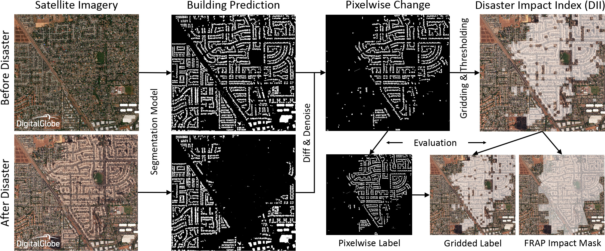
Figure 1: Flow diagram of the proposed approach for disaster impact analysis using CNNs.
The change detection process involves several steps, including dilation of pre-disaster masks and the removal of small noise components. The resulting change mask is used to compute the Disaster Impact Index, a quantitative measure of disaster impact on specified grid regions.
Disaster Impact Index (DII)
The DII metric provides a quantifiable measure of disaster impact by calculating the relative change in detected features within specified grid areas. The DII is computed as the normalized difference between pre- and post-disaster predictions within grid cells. A thresholding mechanism is applied to these indices to identify areas with significant damage.
The normalized aspect of the DII ensures that the metric is independent of region-specific characteristics and can be consistently applied across various scenarios.
Experimental Results
The proposed method was validated using datasets from two significant disaster events: Hurricane Harvey and the Santa Rosa fires. The Hurricane Harvey dataset focused on road changes to assess flood impact, while the Santa Rosa dataset used changes in building structures to evaluate fire impact.
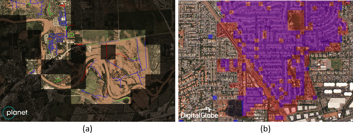
Figure 2: DII application: (a) flood damage during Hurricane Harvey; (b) fire damage at Santa Rosa.
The evaluation revealed high F1 scores in detecting impacted areas, demonstrating the method's effectiveness. The CNN-based detection exhibited strong correlation with ground truth data, confirming the method's viability in operational settings. For instance, the DII-based approach achieved an F1 score of 81.2% for flooding damage detection and 83.5% for fire damage detection.
Conclusion
The study effectively demonstrates the utility of CNNs in conjunction with satellite imagery for automatic disaster impact assessment. By focusing on the changes in man-made structures, the method provides a scalable and efficient alternative to traditional manual mapping techniques. Future work could extend this framework to other structural and natural features, thereby broadening the scope and applicability of the DII metric in varied disaster scenarios.

