OpenCVL: An Open, Diverse, and Large-Scale Dataset for Fine-Grained Cross-View Localization
Abstract: Fine-grained Cross-View Localization (CVL) estimates the precise position and orientation of a ground-level image by aligning it with geo-referenced aerial imagery, offering a scalable alternative to Global Navigation Satellite Systems (GNSS) in challenging urban environments. Existing datasets rely on data collected with high-end sensor suites, which inherently limit image diversity and scalability. While in-the-wild images are abundant, their noisy geo-tags make them unsuitable for reliable evaluation. To bridge this gap, we introduce OpenCVL, a large-scale, diverse, and open dataset containing 617,388 ground-aerial image pairs spanning 41 cities across four European countries. All images are sourced from permissive platforms, ensuring long-term accessibility and supporting open and reproducible research. The training set combines images captured with high-end sensors with diverse in-the-wild imagery. We further develop a data curation framework that filters and corrects pose annotations to construct reliable in-the-wild evaluation data. In addition, OpenCVL includes dedicated cross-area and snowy test sets to assess generalization and robustness. Experiments with a state-of-the-art CVL model on OpenCVL show that incorporating noisy in-the-wild data consistently improves performance on clean test sets, suggesting a promising direction for scaling CVL with diverse real-world imagery.
Paper Prompts
Sign up for free to create and run prompts on this paper.
Top Community Prompts
Explain it Like I'm 14
1. What is this paper about?
This paper introduces OpenCVL, a large, freely available collection of images designed to help computers figure out where a ground-level photo was taken by comparing it with an aerial image.
For example, imagine taking a photo while walking or driving through a city. A computer could compare that photo with an image taken from above and estimate:
- The exact location of the camera
- The direction the camera was facing
This task is called fine-grained cross-view localization. “Cross-view” means comparing two different viewpoints: one from the ground and one from the sky. “Fine-grained” means trying to find the position very precisely, sometimes within a few meters.
This could be useful for self-driving cars, delivery robots, and navigation systems, especially in cities where GPS signals can become unreliable between tall buildings.
2. What questions did the researchers ask?
The researchers wanted to solve several problems with existing image datasets.
Their main questions were:
- Can they create a very large and diverse dataset using images that are legally open to researchers?
- Can images taken by ordinary people—with less accurate GPS information—still help train localization systems?
- Can they improve the inaccurate location information attached to these everyday images?
- Does training with many different cameras, viewpoints, cities, seasons, and weather conditions make computer models more reliable?
- How well do models work in difficult situations, such as snowy scenes or images from places not seen during training?
Existing datasets often use special research vehicles with expensive sensors. These provide accurate information, but the images usually come from similar cameras, camera heights, and driving situations. The researchers wanted a dataset that better represents the messy variety of the real world.
3. How did they do the research?
Building the OpenCVL dataset
The researchers collected:
- Ground-level images from the Zenseact Open Dataset, or ZOD
- Crowd-sourced images from Mapillary
- Aerial images from national mapping agencies
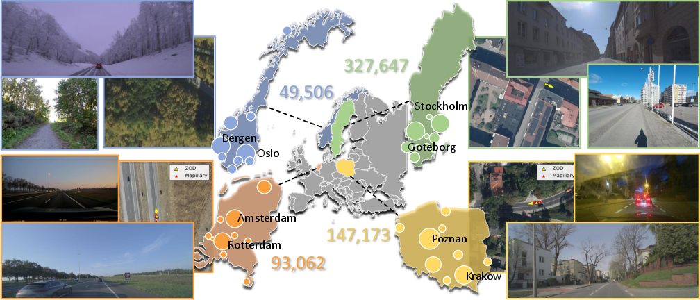
The dataset covers 617,388 pairs of images from 41 cities in:
- Sweden
- Poland
- Norway
- The Netherlands
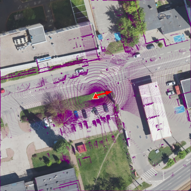
Each pair contains a ground-level image and an aerial image showing the same general area. The aerial images cover an area of about 100 meters by 100 meters.
The images show many different situations. Some were taken:
- From cars
- By cyclists
- By pedestrians
- With phones
- With vehicle-mounted cameras
- In different seasons and weather conditions
- From different directions and camera heights
This variety is important because a computer trained only on forward-facing car images might struggle when shown a photo taken by someone walking on a sidewalk.
Fixing inaccurate location information
Mapillary images have location information from phone-quality GPS. This information can sometimes be wrong by several meters or more. That is a serious problem when the goal is to estimate a position very precisely.
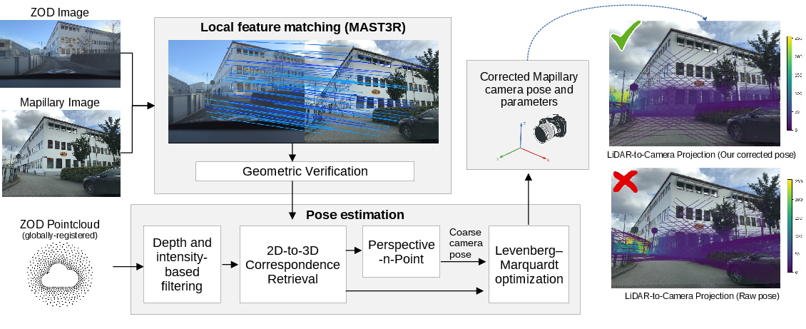
To improve these locations, the researchers used a multi-step process:
- They found Mapillary photos that showed some of the same objects as ZOD photos.
- They matched visual details between the images, such as building corners, signs, or road features.
- They used LiDAR data from ZOD. LiDAR is a sensor that measures distances by sending out laser beams, almost like creating a 3D point cloud of the surroundings.
- They estimated where the Mapillary camera must have been to make the objects line up correctly.
- They removed images where the estimated position was still unreliable.
- They manually checked the remaining examples.
This is similar to solving a puzzle: the researchers used known 3D points and matching objects in photos to work out the camera’s exact position and direction.
Testing a localization model
The researchers tested a state-of-the-art model called Loc².
The model looks for matching features between a ground photo and an aerial image. It might notice that a road bends in a particular way, or that a building has a distinctive shape. It then uses these matches to estimate the camera’s location and direction.
The researchers compared models trained with:
- KITTI, an older dataset with less variety
- Only the accurate ZOD images
- ZOD plus Mapillary images
- ZOD plus Mapillary images, while reducing the influence of Mapillary’s noisier labels
They measured performance using:
- Localization error: how many meters away the prediction was from the correct position
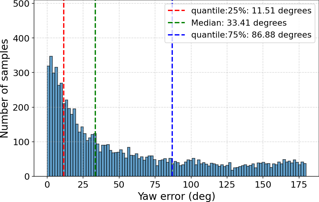
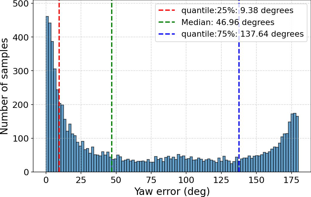
- Orientation error: how many degrees the predicted direction differed from the correct direction
4. What did they find?
OpenCVL is larger and more varied than earlier datasets
OpenCVL contains hundreds of thousands of image pairs and covers many cities and environments. Unlike many earlier datasets, it includes images from open or permissive sources, meaning researchers can more easily access, share, and reproduce the experiments.
It also includes much more variety in:
- Camera types
- Camera heights
- Viewing directions
- Weather
- Seasons
- Geographic areas
- Types of people or vehicles taking the images
Diverse, noisy images can improve training
One of the most important findings was that adding Mapillary images helped the model, even though their original location labels were noisy.
For example, on the cross-area test set:
| Training data | Average location error |
|---|---|
| ZOD only | 7.55 meters |
| ZOD + Mapillary, no special weighting | 6.87 meters |
| ZOD + Mapillary, with noise reduction | 6.72 meters |
The model also improved on the difficult in-the-wild test set. This suggests that seeing many different kinds of images can teach the model to handle real-world variation better.
However, the researchers reduced the importance of Mapillary examples during training. This is like telling the model: “These examples are useful, but their answers may not be perfectly reliable.” This produced better results than treating all labels as equally accurate.
Corrected labels work better than raw GPS labels
The researchers compared different types of Mapillary location information. Training with their corrected poses produced the best results:
| Mapillary location labels | Average location error |
|---|---|
| No Mapillary fine-tuning | 8.05 meters |
| Raw GPS labels | 7.41 meters |
| Mapillary’s improved labels | 7.20 meters |
| Researchers’ corrected labels | 6.92 meters |
This shows that improving the labels makes the crowd-sourced images more useful.
Older training data did not generalize as well
A model trained on KITTI performed much worse on OpenCVL. This is because KITTI mostly contains images from one type of vehicle and one general style of environment.
A model trained on OpenCVL performed much better on OpenCVL’s varied test sets. It also performed about as well as a KITTI-trained model when tested on KITTI, showing that OpenCVL can transfer reasonably well to another dataset.
The hardest cases are still difficult
Even the improved model sometimes made large mistakes. It could:
- Choose the wrong corner of an intersection
- Predict the correct general area but the wrong exact position
- Confuse one direction of travel with the opposite direction
- Struggle with images taken from sidewalks or unusual angles
- Have difficulty matching complicated aerial scenes
The in-the-wild test set showed that real-world localization is still a challenging problem.
OpenCVL can help other datasets too
The researchers also used OpenCVL to train a model before training it further on KITTI. This process is called pre-training followed by fine-tuning.
This approach performed better on KITTI than training on KITTI alone. It suggests that OpenCVL can act like broad practice before a model specializes in a particular environment.
5. Why is this research important?
OpenCVL is important because it makes cross-view localization research more realistic and more open.
Earlier datasets often had accurate labels but limited variety. OpenCVL combines:
- Accurate sensor-based data
- Large amounts of everyday imagery
- Many camera types and viewpoints
- Different weather and seasons
- Wide geographic coverage
- Openly available images
The paper shows that imperfect real-world data should not automatically be thrown away. If researchers identify its weaknesses, correct some labels, and reduce the influence of unreliable examples, the data can still help train better systems.
In the future, this could lead to navigation systems that work more reliably when GPS is blocked or inaccurate. It could help self-driving cars, robots, and phones understand exactly where they are.
The dataset also gives researchers a harder and fairer way to test their systems. Instead of only testing on neat images taken by special vehicles, they can test on photos taken by cyclists, pedestrians, and ordinary cameras.
In simple terms, the paper’s main message is: computers can learn to locate ground-level images more effectively when they are trained on a large, open, and diverse collection of real-world examples—even when some of those examples contain imperfect location information.
Knowledge Gaps
The paper leaves the following knowledge gaps, limitations, and open questions unresolved:
- Limited geographic scope: OpenCVL covers only 41 cities in four European countries, so its applicability to non-European regions, rural areas, megacities, and substantially different architectural or road environments remains unknown.
- Potential geographic and source bias: The dataset is restricted to locations where both ZOD and Mapillary coverage overlap and where suitable open aerial imagery is available, which may bias the sampled environments toward particular countries, cities, and infrastructure types.
- Unclear representativeness of the in-the-wild subset: The paper does not quantify how camera devices, mounting types, user demographics, transportation modes, or image contributors are distributed within the Mapillary data, making it difficult to assess whether the dataset reflects real deployment conditions.
- Incomplete characterization of annotation accuracy: Pose accuracy is described qualitatively and through reprojection filtering/manual inspection, but the paper does not report quantitative position and orientation uncertainty for the corrected Mapillary test labels.
- Dependence on ZOD coverage for pose correction: The Mapillary pose-correction framework requires nearby ZOD images and globally registered LiDAR point clouds, limiting its use in regions without equivalent high-quality sensor data.
- Unmeasured selection bias from pose curation: Images that lack sufficient feature matches or have high reprojection error are discarded, but the paper does not analyze which environmental conditions, viewpoints, camera types, or scene categories are disproportionately removed.
- Manual verification does not scale transparently: The evaluation protocol includes manual pose verification, but the time, annotator agreement, acceptance criteria, and reproducibility of this process are not reported.
- Reliance on a single primary model: Most conclusions about dataset usefulness and noisy-label training are based on Loc; it remains unclear whether the observed improvements generalize to other architectures, loss functions, geometric formulations, or foundation-model-based methods.
- Limited baseline coverage: The experiments do not comprehensively compare retrieval-based, BEV-based, uncertainty-aware, weakly supervised, or multimodal localization methods under a common training and evaluation protocol.
- Insufficient ablation of data diversity factors: The paper shows benefits from adding Mapillary data but does not isolate the effects of geographic diversity, viewpoint diversity, camera diversity, weather, time of day, image quality, or scene type.
- Unresolved optimal strategy for noisy supervision: A single global Mapillary loss weight of $0.3$ is selected, but the paper does not test sample-dependent uncertainty estimation, robust losses, curriculum learning, co-teaching, pseudo-label refinement, or confidence-aware sampling.
- No analysis of noise-level thresholds: The amount and distribution of pose noise in the Mapillary training set are not quantified, leaving unanswered how much annotation noise can be tolerated before diversity benefits are outweighed by supervision errors.
- Potential confounding in the Mapillary pose-quality experiment: Fine-tuning with differently labeled Mapillary images may involve differences in filtering, sample composition, or optimization exposure; the paper does not establish that annotation quality alone explains the performance differences.
- Depth-estimation errors are not evaluated: Loc depends on DepthAnythingV2 depth predictions, with LiDAR-based scale refinement only for ZOD images. The impact of monocular depth errors, especially for Mapillary viewpoints and unusual camera heights, is not measured.
- Camera calibration uncertainty is insufficiently studied: The framework estimates or adjusts intrinsics and distortion parameters for Mapillary images, but the accuracy and failure modes of these estimates are not reported across devices.
- Aerial imagery temporal mismatch is unexplored: Differences between the capture dates of ground-level and aerial images may affect localization, yet the paper does not quantify the temporal gaps or evaluate performance under controlled levels of map staleness.
- Aerial-image heterogeneity is not fully controlled: The four national mapping agencies provide imagery with different resolutions, processing pipelines, radiometric properties, and possibly orthorectification quality. Their individual effects on model performance are not systematically analyzed.
- Orthophoto limitations remain unresolved: The appendix mentions orthophoto versus true orthographic imagery, but the main experiments do not establish how terrain relief, building displacement, or orthorectification artifacts influence localization accuracy.
- Evaluation areas may not be independent enough: The cross-area split is described as geographically non-overlapping, but the paper does not provide detailed distance thresholds or analyses of visual overlap, repeated structures, or sequence-level leakage between training and evaluation sets.
- Temporal and contributor leakage is not examined: Related images from the same Mapillary sequences, contributors, devices, or collection sessions may appear across splits; the extent to which this affects test performance is unknown.
- Snow robustness is narrowly defined: The snowy test set is drawn from ZOD and is not designed for cross-season generalization. Robustness to unseen weather conditions such as rain, fog, glare, autumn foliage, flooding, or nighttime scenes remains untested.
- Long-tail and difficult-scene performance is unclear: Aggregate mean and median errors do not reveal performance for intersections, sidewalks, pedestrian paths, dense urban areas, highways, vegetation-heavy scenes, visually repetitive streets, or severe occlusions.
- Orientation ambiguity is not adequately resolved: Opposite-direction predictions remain common, especially under cross-dataset transfer. The paper does not test explicit heading-disambiguation objectives, temporal cues, semantic road-direction cues, or models that represent multimodal orientation hypotheses.
- Unknown-orientation performance remains weak: The in-the-wild test set still produces large orientation errors, but the paper does not investigate whether errors arise primarily from camera metadata, scene symmetry, viewpoint variation, model architecture, or annotation uncertainty.
- No uncertainty or failure detection evaluation: The methods produce pose estimates, but the paper does not assess calibrated confidence, error bounds, out-of-distribution detection, or the ability to abstain when localization is unreliable.
- Robustness to image degradation is not measured: Effects of blur, compression, low light, occlusion, lens distortion, privacy filtering, motion artifacts, and varying image resolutions are left unexplored.
- No real-time or resource analysis: The paper does not report inference latency, memory use, energy consumption, or suitability for deployment on mobile, robotic, or automotive hardware.
- Scalability of aerial retrieval is not evaluated: Each sample is paired with a aerial image, but the computational and indexing requirements for searching over large regions or entire countries are not addressed.
- Operational GNSS replacement claims remain unvalidated: The paper motivates CVL as a complement or alternative to GNSS, but it does not evaluate localization under actual GNSS-denied, multipath, urban-canyon, or autonomous-navigation scenarios.
- Cross-country transfer is not isolated: Results aggregate four countries, so the paper does not determine whether models transfer across countries or primarily benefit from country-specific visual and mapping cues.
- Cross-dataset transfer evidence is limited: Transfer is evaluated mainly between OpenCVL and KITTI, leaving generalization to other continents, sensors, aerial sources, camera geometries, and proprietary benchmarks unresolved.
- The effect of orientation priors is incompletely characterized: The experiments compare settings with and without a prior, but do not evaluate intermediate prior strengths, inaccurate priors, or realistic prior uncertainty distributions.
- Reproducibility of the full data pipeline is uncertain: Although the data sources are open, the paper does not fully establish whether all preprocessing scripts, filtering thresholds, pose-correction outputs, metadata, and versioned source snapshots will remain available and sufficient to reconstruct the dataset.
- Licensing and long-term availability risks are not examined: The dataset depends on external platforms and national agencies whose terms, APIs, coverage, or licensing conditions may change, potentially affecting future access and exact reproducibility.
- No human or classical-method benchmark is provided: The paper does not establish how model performance compares with human localization ability, geometry-only registration, map-based methods, or hybrid systems using semantic and cartographic information.
- Benefits of noisy data are not theoretically explained: The empirical improvement from Mapillary data is demonstrated, but the mechanisms by which diversity offsets label noise—such as representation learning, regularization, or improved viewpoint coverage—remain unresolved.
Practical Applications
Immediate Applications
- Open, reproducible benchmarking for computer vision research — Academia / software research OpenCVL can be used immediately to train, validate, and compare fine-grained cross-view localization (CVL) models under realistic conditions, including unseen areas, snow, heterogeneous cameras, and unconstrained viewpoints. Its permissive data sources support reproducible experiments, public model releases, and dataset extensions without dependence on restricted Google imagery. Potential outputs: benchmark leaderboards, open-source training pipelines, standardized error reports, and pretrained ground-to-aerial localization models. Dependencies: users must comply with the individual attribution and share-alike requirements of the source licenses; performance may not transfer directly outside the four covered European countries.
- Noise-aware training workflows for geolocation models — Machine learning / software The paper demonstrates that noisy crowd-sourced imagery can improve performance when combined with high-confidence data and downweighted during training. Organizations can immediately adopt a two-tier data pipeline: use accurately labeled sensor data as the core supervision and incorporate crowd-sourced images with lower loss weights, confidence scores, or sample reweighting. Potential tools: dataset mixers, confidence-aware dataloaders, label-quality dashboards, and automated curriculum-learning systems. Dependencies: the reported global Mapillary loss weight of approximately $0.3$ is dataset- and model-specific; production systems should calibrate weights using held-out validation data.
- Automated pose-quality control for crowdsourced imagery — Mapping platforms / geospatial data engineering The proposed workflow—feature matching, geometric verification, LiDAR-based 2D–3D correspondence generation, PnP pose estimation, intrinsic and distortion refinement, reprojection-error filtering, and optional manual review—can be used now to identify unreliable GNSS labels and improve camera poses in crowdsourced street imagery. Potential products: Mapillary-quality auditing services, geotag correction pipelines, data-cleaning APIs, and annotation-assistance tools for mapping companies. Dependencies: the strongest version of the method requires nearby globally registered LiDAR or similarly accurate 3D geometry, sufficient visual overlap with an anchor image, valid camera metadata, and a reliable aerial reference. Performance will degrade in textureless scenes, heavy occlusion, or locations lacking LiDAR coverage.
- Evaluation and acceptance testing for visual localization systems — Autonomous vehicles / robotics / mobility OpenCVL can immediately serve as an offline test suite for systems intended to localize vehicles, bicycles, pedestrians, or robots from camera images against aerial maps. The cross-area, snowy, and in-the-wild splits allow developers to test failure modes that conventional vehicle-mounted datasets underrepresent. Potential workflows: regression testing after model updates, seasonal robustness checks, camera-domain validation, and deployment-readiness reports based on localization and orientation errors. Dependencies: benchmark results are not equivalent to safety certification. The dataset covers mainly European urban environments and does not fully represent tunnels, dense high-rise urban canyons, nighttime scenes, or non-European road infrastructure.
- Pretraining before deployment-specific fine-tuning — Automotive software / robotics The experiments show that OpenCVL pretraining followed by fine-tuning on a target dataset can outperform target-dataset-only training on KITTI. This provides an immediately usable workflow for companies developing localization models for a particular vehicle, camera, city, or orientation convention: pretrain on diverse OpenCVL data, then adapt using a smaller, accurately labeled local dataset. Potential products: camera-agnostic localization backbones, domain-adaptation modules, and fleet-specific fine-tuning pipelines. Dependencies: the target environment should provide representative local data. Orientation priors and training conventions must be kept consistent; mixing data with and without an orientation prior can increase heading errors.
- GNSS-denied or GNSS-assisted positioning prototypes — Autonomous driving, mobile robotics, surveying A CVL model can be integrated as a complementary visual positioning module when GNSS is unreliable, such as in urban canyons or areas affected by multipath. A prototype can compare the estimated camera pose with GNSS, inertial, wheel-odometry, or map-based estimates and use CVL as an additional measurement in a sensor-fusion filter. Potential workflows: fallback localization, GNSS anomaly detection, map-relative vehicle positioning, and visual relocalization after temporary navigation loss. Dependencies: the paper’s reported errors remain several meters on challenging splits and orientation errors can be substantial. Real-time performance, aerial-map freshness, camera calibration, weather robustness, and safety-level validation are required before operational use.
- Data collection and annotation for mapping and geospatial analytics — GIS / mapping agencies / smart cities Mapping organizations can use the dataset and curation methodology to combine authoritative aerial imagery with images collected by cars, cyclists, pedestrians, or smartphones. Corrected poses can support more reliable alignment of street-level observations with road segments, buildings, sidewalks, and intersections. Potential applications: road-condition inventories, sidewalk accessibility mapping, construction monitoring, asset inspection, and georeferenced urban imagery search. Dependencies: aerial imagery must have adequate spatial resolution and current coverage; licensing, privacy, contributor consent, and removal of personally identifiable information must be addressed.
- Educational resources for computer vision and robotics — Teaching / academia OpenCVL can support practical coursework and research projects involving image retrieval, camera pose estimation, feature matching, PnP, uncertainty modeling, domain adaptation, and robustness evaluation. Students can reproduce the paper’s baseline and investigate why models fail on intersections, sidewalks, opposite travel directions, and complex aerial structures. Dependencies: training the largest models may require substantial GPU resources; smaller subsets and pretrained representations should be provided for classroom use.
- Policy and procurement standards for open geospatial AI — Public sector / policy Government agencies can use OpenCVL as evidence that permissively licensed imagery can support large-scale AI development while improving auditability and long-term access. Procurement specifications for public mapping or intelligent-transportation systems can require open or redistributable training data, documented pose uncertainty, cross-area testing, and seasonal robustness evaluation. Dependencies: open licensing alone does not resolve privacy, data protection, security, or national mapping restrictions. Agencies must verify that imagery licenses permit the intended commercial or governmental use.
- Consumer and daily-life location assistance prototypes — Mobile devices / accessibility A smartphone application could use a camera image and aerial imagery to estimate a user’s position or heading when ordinary GNSS is inaccurate. Possible uses include visual orientation assistance, geotag correction for photographs, improved pedestrian navigation, and recovery of a map position in dense urban areas. Dependencies: current performance is not sufficient to replace GNSS for safety-critical navigation. The application requires network access or locally cached aerial maps, low-latency inference, privacy safeguards, and careful handling of ambiguous views and incorrect opposite-direction predictions.
Long-Term Applications
- Robust GNSS replacement or multi-modal navigation for autonomous vehicles — Automotive / transportation With improved accuracy, calibrated uncertainty, temporal map updating, and reliable heading disambiguation, CVL could become a persistent positioning modality for autonomous cars in urban areas where satellite navigation is degraded. It could be fused with LiDAR, inertial measurements, odometry, and HD maps to provide redundancy rather than relying on one sensor. Dependencies: the current in-the-wild results show meaningful residual errors, especially in orientation. Deployment would require near-real-time inference, broad geographic coverage, night and adverse-weather data, protection against adversarial or misleading visual cues, and safety validation under rare failures.
- Global pedestrian, cyclist, and delivery-robot localization — Robotics / logistics / smart cities The inclusion of sidewalk, bicycle, handheld, and non-forward-facing imagery could eventually enable localization models designed specifically for delivery robots, drones operating near buildings, mobility aids, and pedestrian navigation. Unlike conventional driving datasets, the data distribution better reflects off-road viewpoints. Dependencies: more training and evaluation data are needed for pedestrian-scale motion, occluded streets, private paths, dense vegetation, indoor-to-outdoor transitions, and cities outside Europe. Aerial imagery must also resolve narrow paths and local infrastructure sufficiently.
- Worldwide, continuously updated visual mapping — Geospatial industry / public infrastructure A scalable version of the curation framework could turn continuously uploaded street imagery into accurately posed observations aligned with national aerial maps. This could support change detection, map maintenance, road and sidewalk inventories, and rapid updating after floods, storms, construction, or other disruptions. Dependencies: scaling LiDAR-assisted pose correction to countries without dense 3D coverage is a major research problem. Long-term operation also requires automated privacy filtering, duplicate detection, temporal reasoning, contributor-quality estimation, and governance for conflicting or outdated imagery.
- Self-supervised and weakly supervised CVL at continental scale — AI research / mapping platforms The finding that diverse noisy data improves clean-test performance motivates methods that learn from billions of weakly geotagged images rather than requiring precise poses for every sample. Future systems could combine uncertainty-aware losses, pseudo-label refinement, contrastive learning, temporal consistency, active learning, and teacher–student models. Dependencies: noisy labels may introduce systematic geographic or camera biases. Reliable uncertainty estimation, geographically balanced sampling, contamination-resistant evaluation, and accurate validation sets remain necessary.
- Cross-season and long-term temporal localization — Climate resilience / transportation / environmental monitoring A mature CVL system could match current ground imagery to older aerial imagery despite snow, foliage changes, lighting differences, construction, and seasonal appearance changes. This would support year-round navigation and visual change monitoring. Dependencies: OpenCVL includes temporal and snowy variation but does not fully solve large structural changes or long-term map aging. Models need explicit temporal modeling and evaluation across substantially different acquisition years.
- Privacy-preserving visual geolocation services — Consumer software / enterprise platforms Future mobile or edge systems could perform ground-to-aerial localization locally, returning only an approximate pose rather than uploading raw street images. Such systems could provide navigation, photo geotagging, and asset inspection while reducing exposure of faces, license plates, homes, and bystanders. Dependencies: edge deployment requires model compression, efficient aerial-map retrieval, local map storage, and robust privacy testing. Approximate location itself can be sensitive and must be protected through access controls and data minimization.
- Standardized public-sector resilience and navigation infrastructure — Policy / emergency response Once robustness improves, municipalities and emergency agencies could use visual localization to support navigation during GNSS interference, infrastructure outages, or disaster response. Field personnel could align smartphone or body-camera imagery with aerial maps to locate damaged roads, blocked routes, or isolated assets. Dependencies: emergency environments often contain smoke, debris, flooding, darkness, and rapidly changing geometry—conditions not adequately covered by the current benchmark. Systems would require offline operation, uncertainty-aware interfaces, independent sensor checks, and human confirmation.
- Commercial visual positioning APIs and developer platforms — Software / location services A mature ecosystem could expose APIs that accept a ground-level image and return a position, heading, confidence interval, and matching aerial region. Developers could integrate this into fleet management, augmented reality, robotic delivery, surveying, digital twins, and location-aware media applications. Dependencies: commercial deployment requires global licensing for aerial imagery, predictable service-level latency, abuse prevention, privacy compliance, geographic coverage, and calibrated confidence estimates. The paper’s results demonstrate feasibility of the data and training direction, but not yet production-grade API reliability.
- Urban digital twins and infrastructure inspection — Construction, utilities, insurance, and smart-city analytics Future systems could automatically register images from inspection vehicles, cyclists, drones, or citizens against aerial maps and digital-twin coordinates. This would enable consistent spatial indexing of utility assets, building changes, road defects, vegetation, and construction progress. Dependencies: fine-grained CVL alone does not provide object detection, 3D reconstruction, or semantic interpretation. It must be combined with inspection-specific vision models, updated base maps, accurate vertical geometry, and procedures for handling uncertain or stale registrations.
Glossary
- 3-DoF camera pose: A camera pose represented by three degrees of freedom, typically two-dimensional position and orientation. “estimates the 3-DoF camera pose of the ground image via scale-aware Procrustes alignment”
- Bird’s-eye-view (BEV) space: A top-down representation of a scene as if viewed from above. “project the ground view into birdâs-eye-view space to facilitate geometric alignment with aerial imagery”
- Camera intrinsics: Internal camera parameters, such as focal length and principal point, that describe image formation. “including the camera intrinsics and distortion parameters”
- Camera pose: The position and orientation of a camera relative to a reference coordinate system. “we manually verify the accuracy of the camera poses”
- Coarse localization: Estimation of a geographic position with relatively low spatial precision. “where a prediction is deemed correct if it lies within a radius of the true position”
- Cross-area generalization: A model’s ability to perform well in geographic areas not represented in its training data. “cross-area generalization to unseen locations”
- Cross-view localization (CVL): Estimating the location and orientation of a ground-level image by matching it with aerial or satellite imagery. “Fine-grained Cross-View Localization (CVL) aims to estimate the precise geographic location and orientation of a ground-level query image”
- Crowd-sourced imagery: Images contributed by many members of the public rather than collected by a single controlled acquisition system. “Mapillary is an open platform hosting crowd-sourced street-level imagery from across the world”
- Data curation: The process of selecting, cleaning, correcting, and organizing data for reliable use. “we develop a data curation framework that automatically filters and corrects labels of in-the-wild imagery”
- Data distribution: The statistical characteristics of data, including its types, viewpoints, locations, and capture conditions. “KITTI follows a different data distribution from OpenCVL”
- Depth map: An image in which each pixel records the estimated distance from the camera to the corresponding scene point. “its scale-aware Procrustes alignment requires camera intrinsics and the depth map for each ground-level image”
- Distortion parameters: Camera-specific coefficients that model optical distortions affecting image geometry. “refined along with the camera intrinsics and distortion parameters using LevenbergâMarquardt optimization”
- End-to-end learning: Training a complete model jointly from input data to final predictions. “The method is trained end-to-end using only camera pose supervision”
- Euclidean distance: The straight-line distance between two points in a geometric space. “Localization error is measured as the Euclidean distance in meters between the predicted and ground-truth planar positions”
- Fine-grained localization: Localization that estimates position and orientation with high spatial and angular precision. “This task is commonly divided into image retrieval and fine-grained localization”
- Geometric alignment: Spatially registering representations so that corresponding structures occupy consistent positions. “by projecting them together with the recorded LiDAR point clouds into aerial imagery and inspecting their geometric alignment”
- Geometric verification: A procedure that rejects feature matches inconsistent with a common geometric transformation. “with reciprocal matching and geometric verification to filter outliers”
- Georeferenced imagery: Imagery associated with known geographic coordinates. “by matching it to georeferenced aerial imagery”
- Global coordinates: Coordinates defined in a worldwide reference frame rather than a local camera or vehicle frame. “transforming each 3D point into global coordinates”
- Global Navigation Satellite Systems (GNSS): Satellite-based systems used to determine position, velocity, and time. “offering a scalable alternative to Global Navigation Satellite Systems (GNSS) in challenging urban environments”
- Ground sampling distance (GSD): The physical ground distance represented by one image pixel. “have a ground sampling distance ranging from 0.04~m/pixel to 0.16~m/pixel”
- Ground-truth pose: The reference camera position and orientation treated as the correct target for training or evaluation. “However, such coarse ground-truth pose labels are inadequate for evaluating fine-grained CVL”
- Image retrieval: Finding the most relevant image from a database in response to a query image. “Cross-view image retrieval targets large-scale, coarse localization”
- In-the-wild imagery: Data captured under uncontrolled, naturally occurring conditions using diverse devices and viewpoints. “their noisy geo-tags make them unsuitable for reliable evaluation”
- Levenberg–Marquardt optimization: A nonlinear least-squares optimization method that combines gradient-descent and Gauss–Newton behavior. “using LevenbergâMarquardt optimization”
- LiDAR point cloud: A three-dimensional collection of points measured using light detection and ranging. “ZOD also provides LiDAR point clouds”
- Local feature correspondences: Associations between visually matching local regions or keypoints in different images. “dense local feature correspondences between ground and aerial images can also be directly established”
- Local feature extractor: A model or algorithm that identifies informative local visual features in an image. “the state-of-the-art local feature extractor MAST3R”
- Metric depth: Depth expressed in physical units rather than only up to an unknown scale. “we use DepthAnythingV2 to predict metric depth for all ground-level images in OpenCVL”
- Multipath effects: Positioning errors caused when satellite signals reflect from surfaces before reaching a receiver. “such as urban canyons and dense city centers, making it highly promising for self-driving”
- North-aligned: Oriented so that geographic north corresponds to a fixed image direction. “All aerial images are north-aligned”
- Orientation prior: Assumed prior information constraining the likely camera orientation. “with an orientation prior (with noise within ) during both training and testing”
- Perspective image: An image formed by projecting a three-dimensional scene onto a camera plane with perspective geometry. “which are not directly comparable to the perspective images in OpenCVL”
- Perspective-n-Point (PnP): A computer-vision problem that estimates camera pose from known 3D points and their corresponding 2D image projections. “estimate a coarse Mapillary camera pose using Perspective-n-Point (PnP)”
- Planar position: A position represented in a two-dimensional ground or map plane. “between the predicted and ground-truth planar positions”
- Pose annotation: A labeled estimate of an image or camera’s position and orientation. “accurate pose annotations are required”
- Pose estimation: The computation of a camera’s position and orientation from visual or sensor observations. “The quality of pose estimation is then determined via the reprojection error”
- Procrustes alignment: A method for aligning two sets of corresponding points through transformations such as rotation, translation, and scaling. “via scale-aware Procrustes alignment”
- Reprojection error: The discrepancy between an observed image point and the projection of its corresponding 3D point under an estimated camera model. “such that the pose estimates with higher reprojection error are automatically discarded”
- Robustness: The ability of a model to maintain performance under changes, noise, or adverse conditions. “to assess model robustness under different conditions”
- Scale-aware alignment: Alignment that explicitly estimates or accounts for differences in spatial scale between representations. “via scale-aware Procrustes alignment”
- Sensor rig: An integrated assembly of multiple sensors mounted together for synchronized data collection. “collected using vehicle-mounted sensor rigs equipped with a front-facing camera, a LiDAR, and a high-end GNSS”
- State-of-the-art: Representing the best or among the best currently reported performance or methods in a field. “We adopt the recent state-of-the-art fine-grained CVL method”
- Supervision: Training information, such as labels or poses, used to guide a machine-learning model. “high-confidence supervision from ZOD and noisier supervision from Mapillary”
- Temporal diversity: Variation in image acquisition times, seasons, lighting, or weather. “The dataset encompasses diverse geographic regions and provides substantial variability in camera types, viewpoints, as well as temporal and weather conditions.”
- Visual overlap: The extent to which two images depict common physical scene content. “Visual overlap between the ZOD and Mapillary images is then verified”
- Weakly supervised learning: Learning with incomplete, noisy, or indirect labels rather than fully precise annotations. “several works explore weakly supervised learning strategies to reduce reliance on precise ground-truth annotations”
- Yaw angle: Rotation around the vertical axis, commonly representing horizontal viewing direction. “orientation error measures the absolute angular difference between the predicted and ground-truth yaw angles”

