- The paper presents a hybrid method that integrates patch-level self-supervised learning via an OctFormer backbone to bridge the domain gap between aerial and ground LiDAR point clouds.
- It combines scene-level triplet loss with an expanded reciprocal re-ranking algorithm to significantly enhance recall rates and mAP, mitigating false positives in urban environments.
- The introduction of the CS-Urban-Scenes benchmark validates the approach, with improvements of up to 10.2% in AR@1 and doubled mAP scores, indicating state-of-the-art performance.
Aerial-Ground LiDAR Place Recognition via Patch-Level SSL and Expanded Reciprocal Re-ranking
Introduction
The paper "Aerial-ground LiDAR place recognition with patch-level self-supervised learning and expanded reciprocal re-ranking" (2606.18583) addresses the complex task of reliably localizing ground-level mobile mapping and robotic platforms within large-scale, geo-referenced airborne LiDAR (ALS) databases. The method overcomes key limitations of traditional ground-level LiDAR place recognition—including incomplete coverage and perspective blockages—by exploiting full-coverage ALS prior maps. However, this approach introduces significant challenges in cross-source retrieval, specifically (1) the domain gap between aerial and ground point clouds due to differences in density, coverage, and sensor noise; (2) numerous false positives caused by repetitive urban structures; and (3) the absence of adequately large and diverse aerial-ground benchmarks.
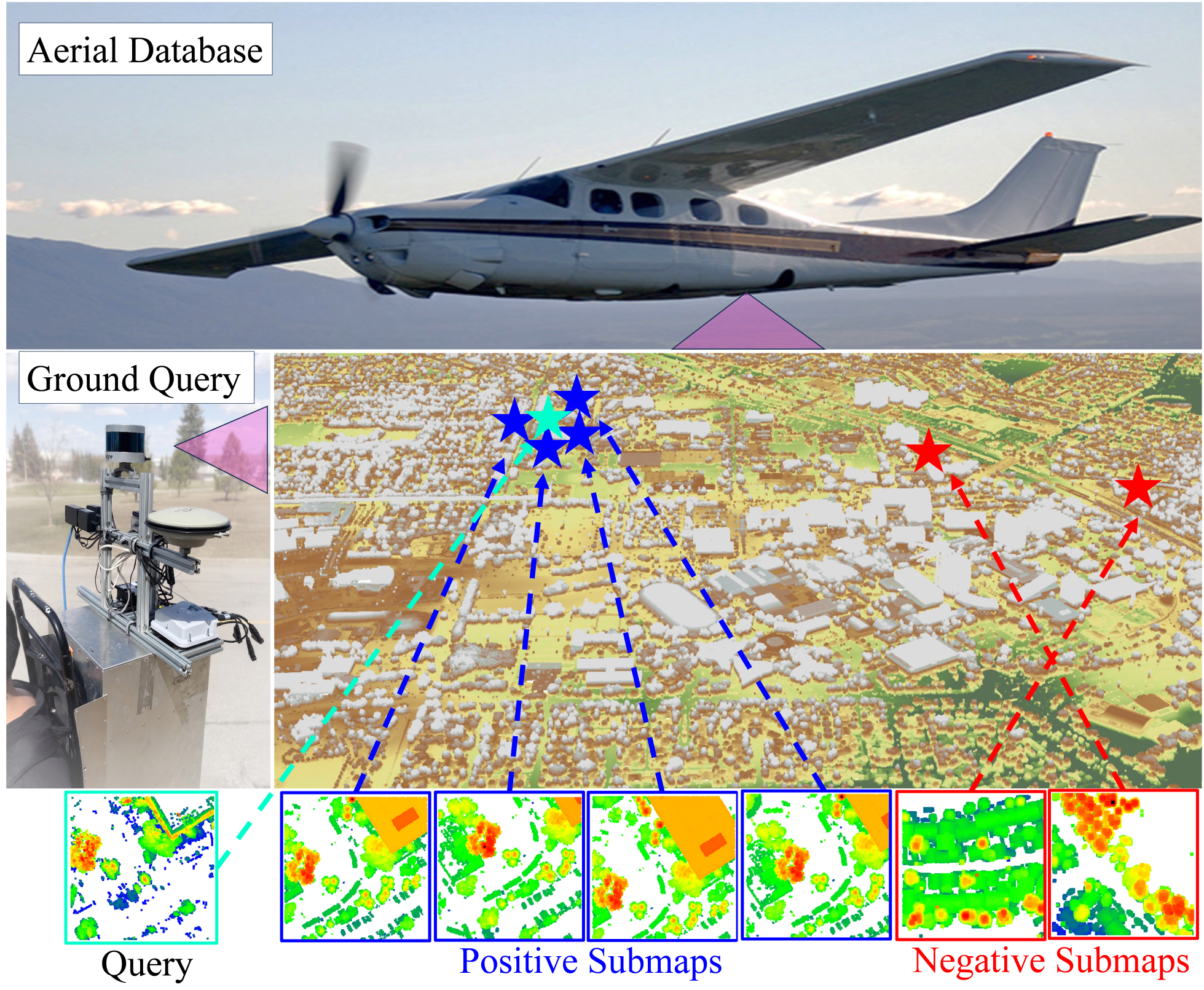
Figure 1: Diagram of aerial-ground LiDAR place recognition; blue and red asterisks indicate positive and negative candidates within the ALS database relative to a ground query.
Domain Gap and Patch-Level Learning
The domain gap between aerial and ground point clouds arises from coverage variation, density discrepancies, and non-uniform sensor noise, undermining conventional metric learning pipelines (Figure 2). Existing retrieval algorithms, such as MinkLoc3D and CrossLoc3D, rely exclusively on scene-level global descriptors and neglect fine-grained local patch semantics, rendering them susceptible to cross-source ambiguities.
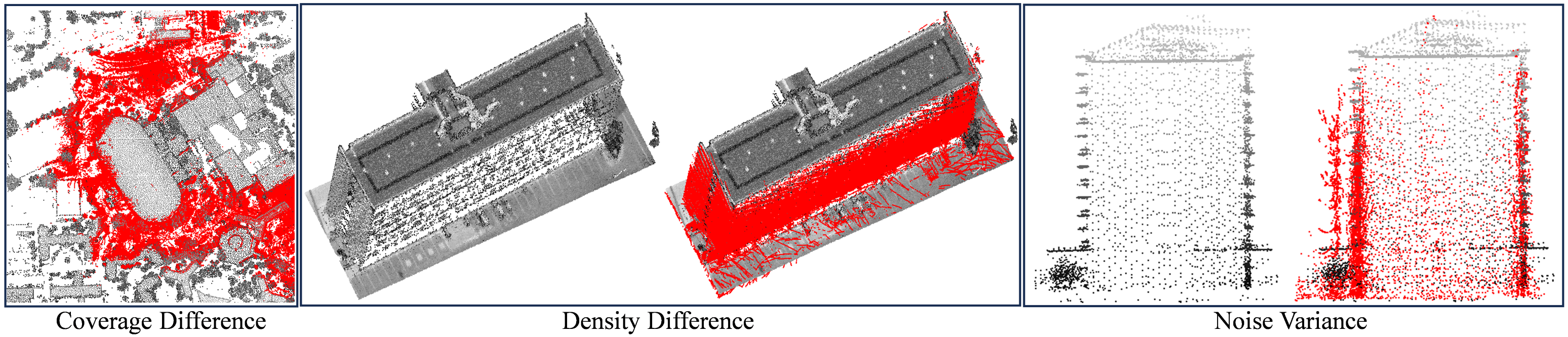
Figure 2: Domain gap visualization between aerial (gray) and ground (red) point clouds.
To address this, the paper introduces a retrieval pipeline that incorporates multi-scale patch-level self-supervised learning (SSL) alongside classic scene-level metric objectives. The backbone is OctFormer, which offers scalable attention via octree partitioning, enabling the extraction of patch features at multiple spatial scales. Scene-level triplet loss optimizes global descriptor discriminativeness, while patch-level SSL distills semantic consistency across neighboring patches, leveraging asymmetric teacher-student distillation via cross-attention modules to align local patch features and enhance robustness to domain gaps.
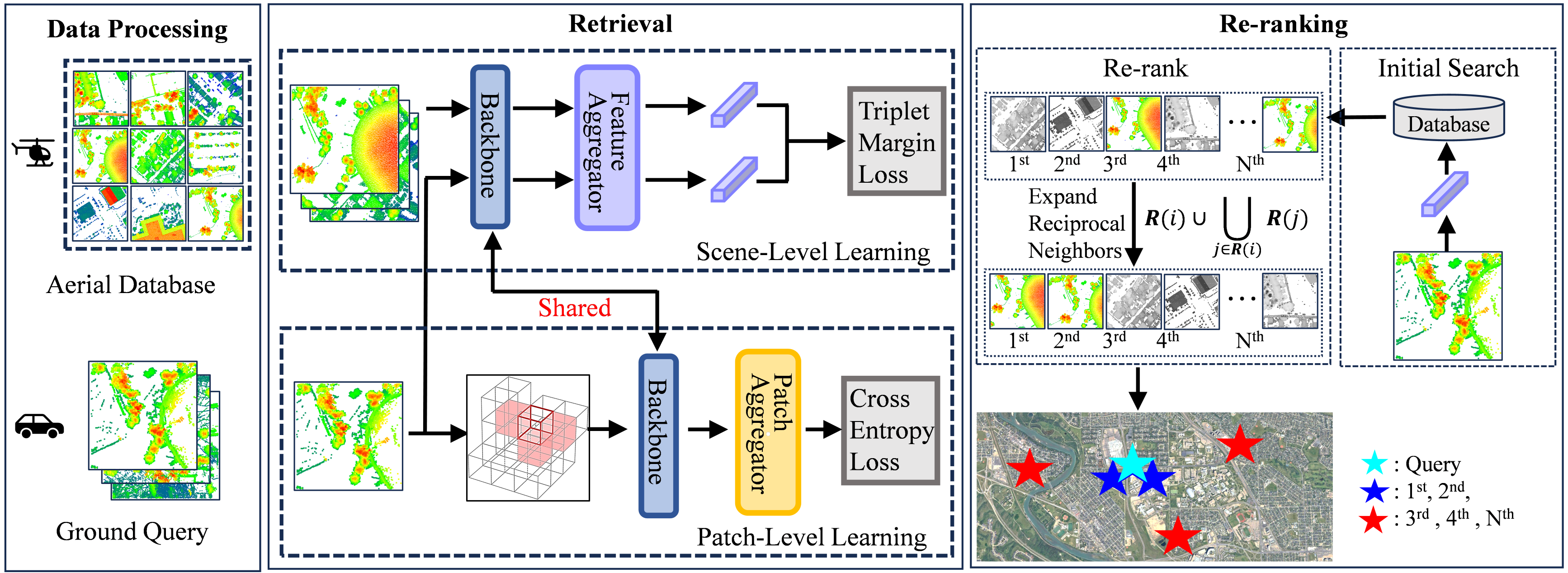
Figure 3: Overview of the method combining scene-level triplet optimization and patch-level SSL; ER re-ranking refines candidate rankings post-retrieval.
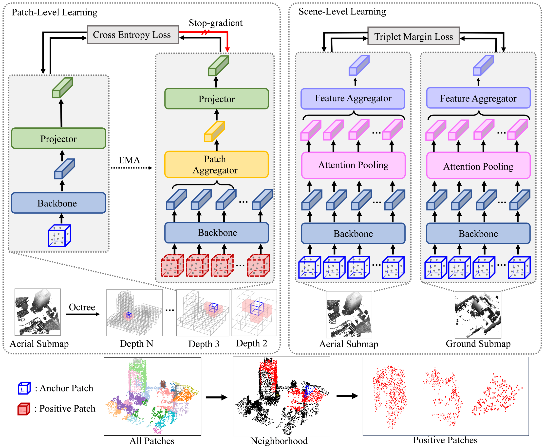
Figure 4: Architecture: Multi-scale patch-level SSL modules and scene-level metric learning integrated within OctFormer backbone.
Expanded Reciprocal Re-Ranking
To filter false positives deriving from structural repetitions in urban ALS databases, the method proposes a training-free Expanded Reciprocal (ER) re-ranking algorithm exploiting database spatial continuity. Classic re-ranking techniques (e.g., k-reciprocal, ECN, graph propagation) are limited by their non-spatial context, whereas the ER mechanism leverages mutual neighborhood relationships: reciprocal neighbors are those among top-k candidates who reciprocally include the query in their list (Figure 5). Neighborhood expansion further incorporates transitive reciprocal associations, averaging embedded features within expanded neighborhoods to refine similarity scores and yield updated rankings.
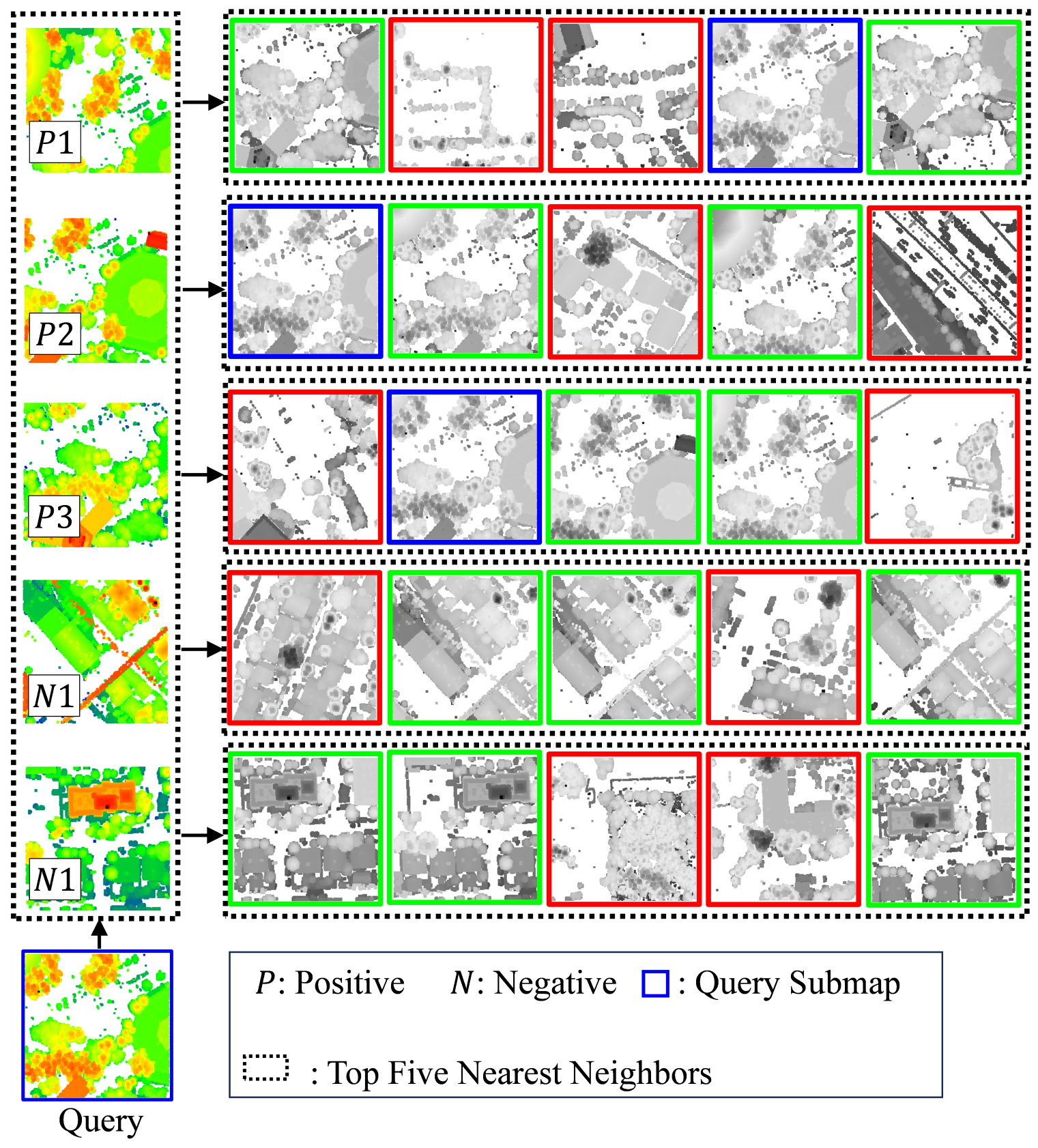
Figure 5: Reciprocal neighbors definition—mutual inclusion within top-k candidates enables filtering of false positives.
Large-Scale Benchmark: CS-Urban-Scenes
A major contribution is the establishment of the CS-Urban-Scenes dataset, encompassing 18.1 km of backpack-acquired MLS trajectories and 7.2 km2 of ALS coverage. The ground dataset is post-processed for precision via PPK, partitioned into 100 m-radius submaps sampled every 2 m, while aerial data is segmented into 100×100m2 grid submaps. The resultant benchmark supports rigorous evaluation in dense urban environments characterized by diverse structures and challenging cross-domain conditions.
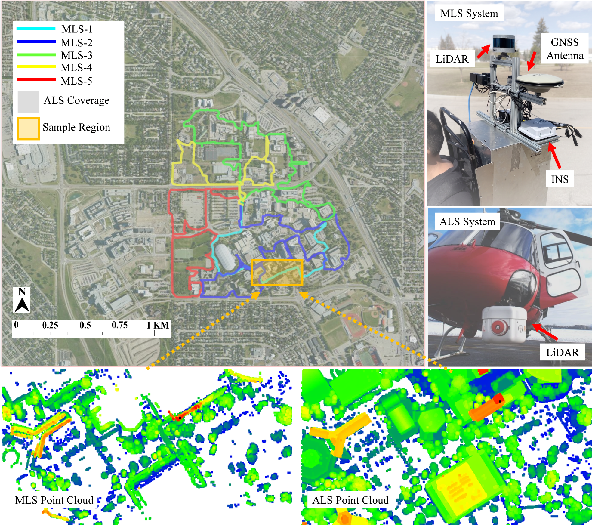
Figure 6: CS-Urban-Scenes coverage—satellite imagery overlays both ground and aerial point clouds across 3 km × 2.4 km.
Experimental Validation and Numerical Results
Retrieval performance is evaluated across CS-Campus3D and CS-Urban-Scenes benchmarks using AR@1, AR@1%, and mAP metrics. Incorporating patch-level SSL improves AR@1 by 5.6–5.7% relative to scene-only baselines, obtaining state-of-the-art recall rates (e.g., 81.1% AR@1 on CS-Campus3D; 86.0% AR@1 on CS-Urban-Scenes). Further, the ER re-ranker yields substantial accuracy boosts without additional training: improvements of 4.9% and 10.2% in k0, and doubling mAP scores (from 33.4% to 57.9%) in urban datasets.
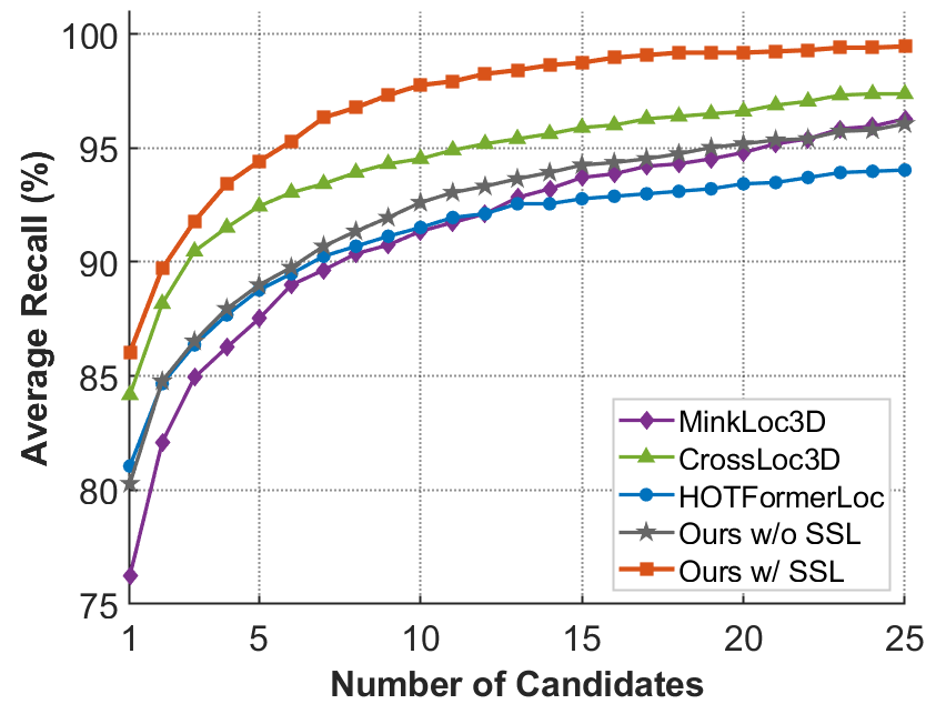
Figure 7: Retrieval recall curves highlighting superior performance of patch-level SSL and ER re-ranking on CS-Urban-Scenes.
Qualitative results illustrate that ER re-ranking promotes spatial clustering of top-25 candidates near query centers and elevates true positives to rank-1, especially in challenging urban scenes (Figures 9–11).
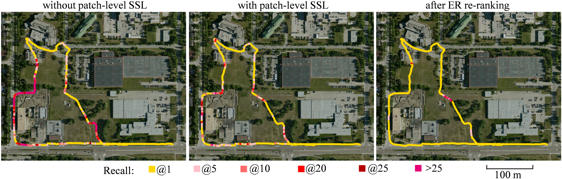
Figure 8: Recall maps—color-coded trajectory points (k1 to k2) confirm improved recall after ER re-ranking.
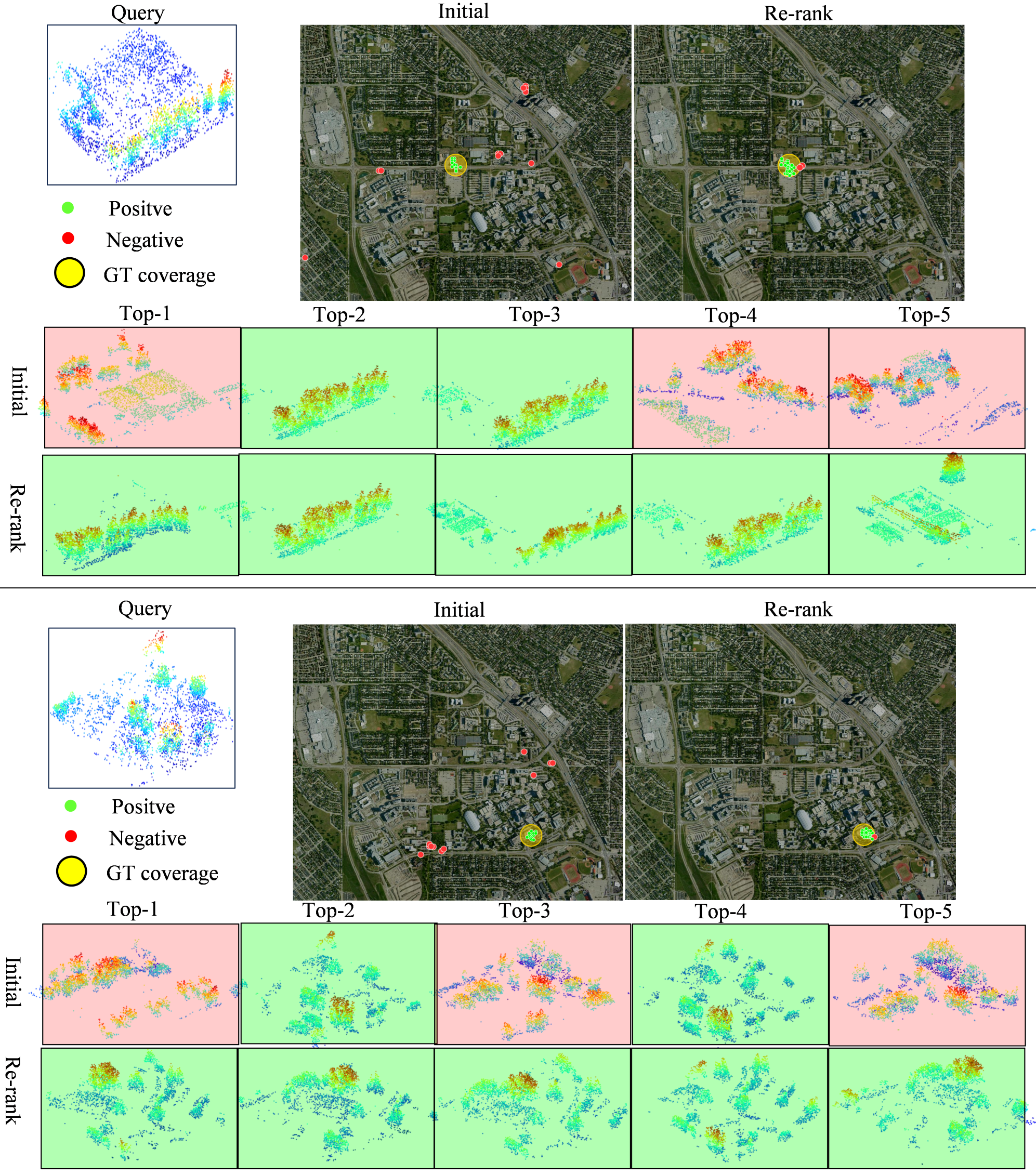
Figure 9: Successful queries after ER re-ranking—true positives promoted to rank-1; candidates cluster spatially on aerial imagery.
Ablation Studies and Efficiency
Ablation studies establish optimal configurations: four positive patches per anchor yield maximal recall; multi-scale patch-level SSL (across octree depths) further augments performance. Re-ranking neighborhood parameter sensitivity shows best results for k3 (CS-Campus3D) and k4–k5 (CS-Urban-Scenes). The retrieval pipeline exhibits competitive inference times (~4.7 ms per query), while ER re-ranking is more efficient than k6-reciprocal and more thorough than top-only augmentation methods.
(Figure 10 & 13)
Figure 10: Sensitivity of ER neighborhood size (k7) on CS-Campus3D; Figure 11: Sensitivity on CS-Urban-Scenes.
Attention map visualizations demonstrate that patch-level SSL induces more semantically focused attention distributions, while failure case analysis underscores the limitations imposed by domain gap, structural repetition, and noise (Figures 14–15).
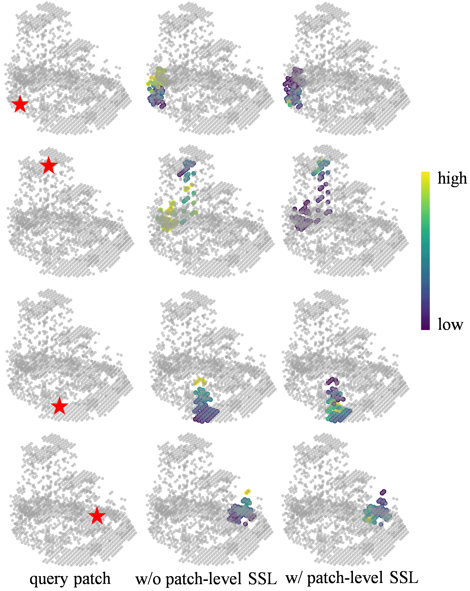
Figure 12: Attention maps—patch-level SSL sharpens semantic focus within octree windows.
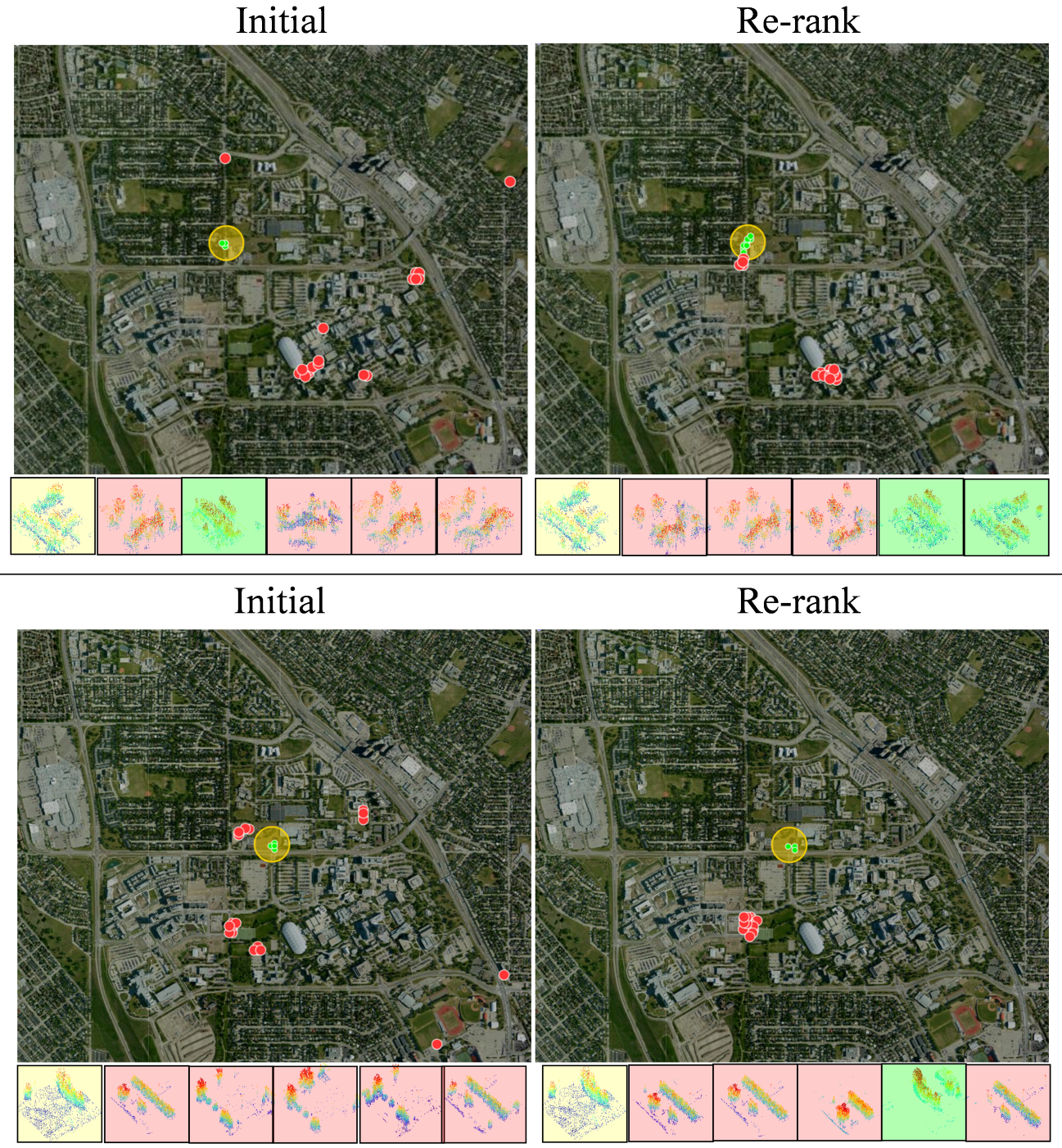
Figure 13: Failure cases—ER re-ranking clusters candidates spatially but ambiguity remains in domain gap scenarios.
Implications and Future Directions
The proposed cross-view LiDAR retrieval framework achieves robust localization in urban environments, exploiting full-coverage aerial prior maps for scenarios where GNSS/INS/visual systems are unreliable. The hybrid metric/SSL learning scheme and ER re-ranking demonstrate practical gains in computational efficiency and recall accuracy, without necessitating additional training phases. Importantly, the structured use of spatial context substantially reduces false positives endemic to large-scale ALS databases.
Practically, this yields enhanced external localization sources for MMS/robotic multi-sensor fusion, supporting long-term autonomy in urban canyons and GNSS-denied environments. Theoretically, it advances domain-adaptive feature aggregation for heterogeneous point cloud modalities and suggests that multi-scale SSL is essential for cross-source retrieval.
Future research should focus on extending the pipeline toward direct 6-DoF pose estimation via global absolute pose regression or scene coordinate regression, addressing the limitations of coarse-to-fine registration under severe domain gaps. Efficient, scalable registration across city-scale aerial datasets remains an unsolved bottleneck. Sequential localization paradigms and integration with multimodal mapping (e.g., cross-image/point correspondence) are likely avenues for further development.
Conclusion
The paper delivers a principled, efficient solution for aerial-ground LiDAR place recognition, bridging cross-source domain gaps through joint scene-level and patch-level SSL, and eliminating false positives via Expanded Reciprocal re-ranking. New urban-scale benchmarks and rigorous evaluations validate its superiority, with direct implications for robust, scalable geospatial localization in large-scale mapping and robotics environments. Extension to pose estimation and further reduction of domain gap effects are pertinent directions for subsequent research.

