GeoGS-SLAM: Geometry-Only Gaussian Splatting for Dense Monocular SLAM
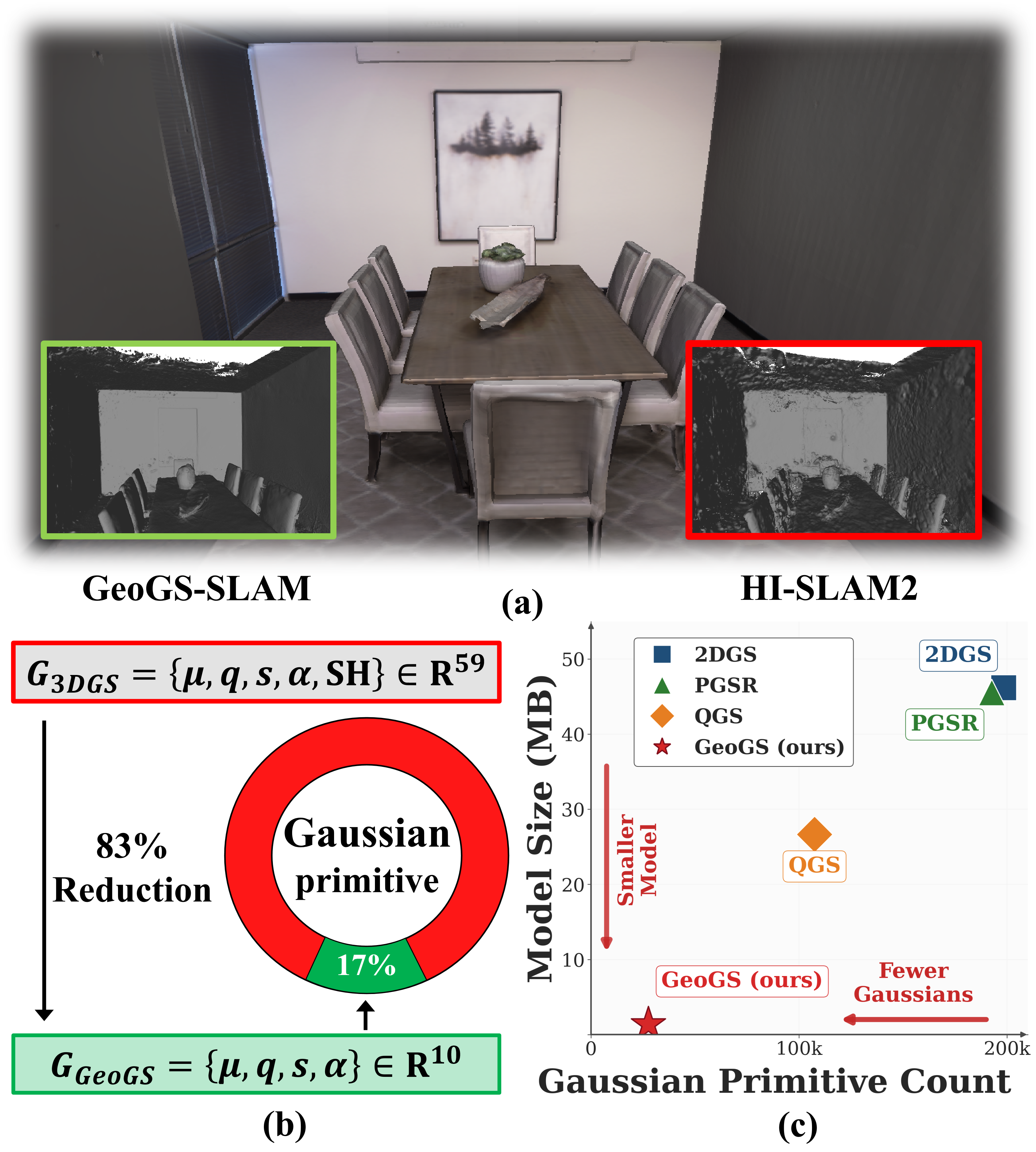
Abstract: Dense visual SLAM is a fundamental problem in robotics. Recent advances in 3DGS have demonstrated its potential for dense SLAM. Existing 3DGS frameworks focus on both appearance and geometry modeling. However, scene geometry is typically more critical for SLAM than novel view synthesis because downstream robotic tasks, such as navigation and obstacle avoidance, rely primarily on accurate spatial geometry rather than photorealistic rendering. This observation raises a natural question: Is it feasible for 3DGS to perform 3D reconstruction without scene appearance modeling? Motivated by this, we propose Geometry-only Gaussian Splatting (GeoGS), which directly reconstructs scene geometry, and further present GeoGS-SLAM, a dense visual SLAM system built upon this representation. Specifically, GeoGS retains only spatial parameters to reduce the number of per-primitive parameters by over 80%. In contrast to existing 3DGS methods, GeoGS focuses solely on geometric reconstruction, which significantly reduces the number of Gaussian primitives, accelerates geometric convergence, and enhances robustness to illumination variations. In addition, we present an effective training framework that optimizes the Gaussian primitives via single-view and multi-view geometric and photometric supervision, and speeds up geometry convergence with a local-plane driven initialization that better aligns primitives with local structures. Furthermore, we introduce a map update strategy for loop closure that globally transforms the Gaussian map to align it with the corrected pose estimates, thereby preventing map tearing caused by inconsistent per-viewpoint pose corrections in existing methods. Extensive experiments on synthetic and real-world benchmarks demonstrate that our method outperforms SOTA methods in terms of online mapping efficiency and geometric reconstruction quality.
Paper Prompts
Sign up for free to create and run prompts on this paper using GPT-5.
Top Community Prompts
Explain it Like I'm 14
What is this paper about?
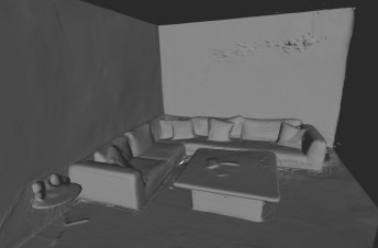
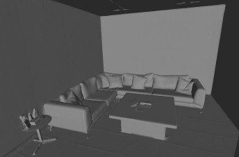
This paper introduces a new way for robots (or phones, drones, AR glasses) to build a detailed 3D map of the world from just a single moving camera. The method is called GeoGS-SLAM. Its big idea is to focus only on the shape of the scene (the geometry) and ignore colors and lighting. That makes the system faster, simpler, and more reliable for tasks like navigation and obstacle avoidance.
Think of it like making a 3D model out of plain white foam instead of painting it realistically. If your goal is to move safely through a space, the shape matters much more than the colors.
What questions are the authors asking?
In simple terms, they ask:
- Can we use “Gaussian splats” (soft 3D blobs that build up a scene) to reconstruct accurate 3D shape without modeling color at all?
- Will dropping color make mapping faster and more robust?
- How can we train such a system without the usual “compare the rendered image to the real image” step, since we’re not rendering color?
- When we fix past pose errors (like realizing we walked in a loop), how do we update the 3D map cleanly without causing the model to “tear” or fall apart?
How does their method work?
To make this clear, here are the main parts, with simple analogies.
The idea of “Geometry-only Gaussians”
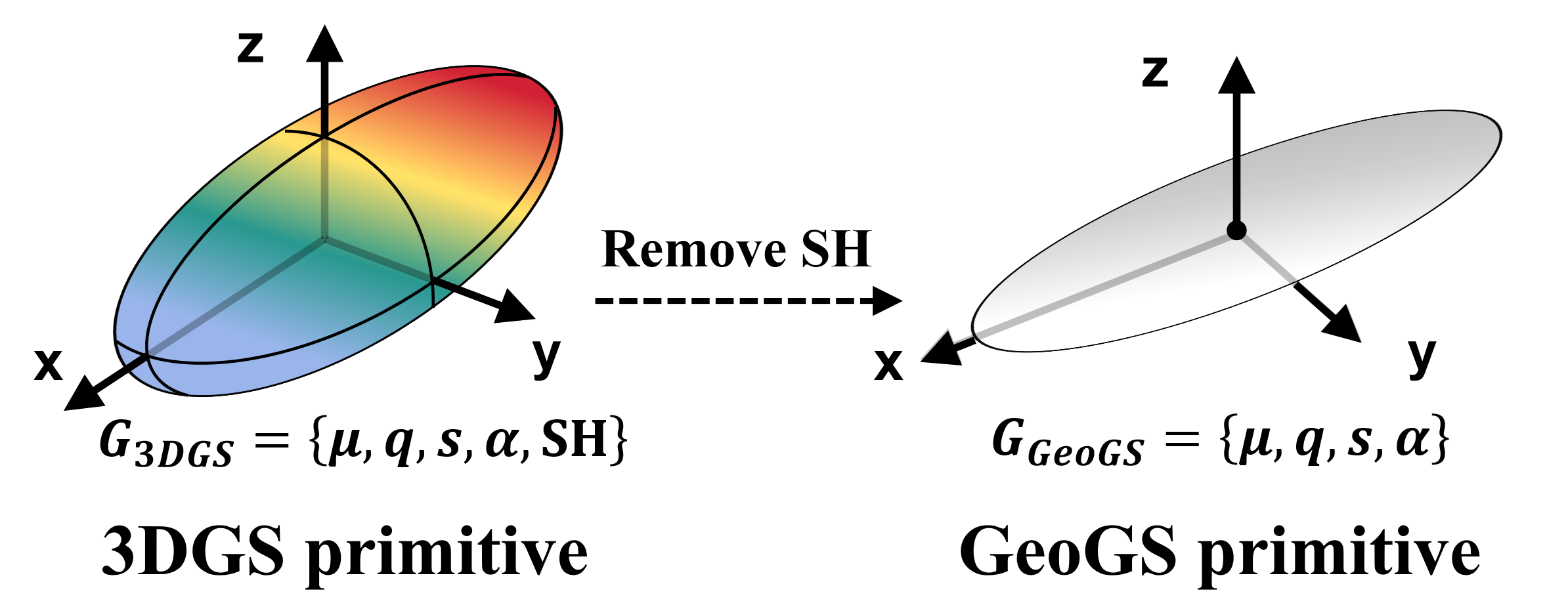
Normal 3D Gaussian Splatting represents a scene using many little fuzzy ellipsoids (Gaussians). Each Gaussian has:
- Where it is (position),
- How it’s oriented (rotation),
- How big it is (scale),
- How opaque it is (opacity),
- And what it looks like (color and view-dependent appearance, often stored as spherical harmonics).
GeoGS removes the last part: it throws away all the appearance/color information and keeps only the geometry-related pieces (position, rotation, scale, opacity). That:
- Cuts the number of parameters per Gaussian by over 80%.
- Lets the system use fewer Gaussians overall to describe the scene.
- Makes optimization (learning the shape) faster and less sensitive to lighting changes.
Analogy: Instead of building a model from colorful LEGO pieces with patterns, you use plain white bricks. It’s quicker to build the shape and you don’t get distracted by colors.
How they “train” without color
Most previous methods learn by rendering a colored image from the 3D model and comparing it to the real camera image (photometric loss). But GeoGS doesn’t model color. So how do they learn?
They supervise geometry directly:
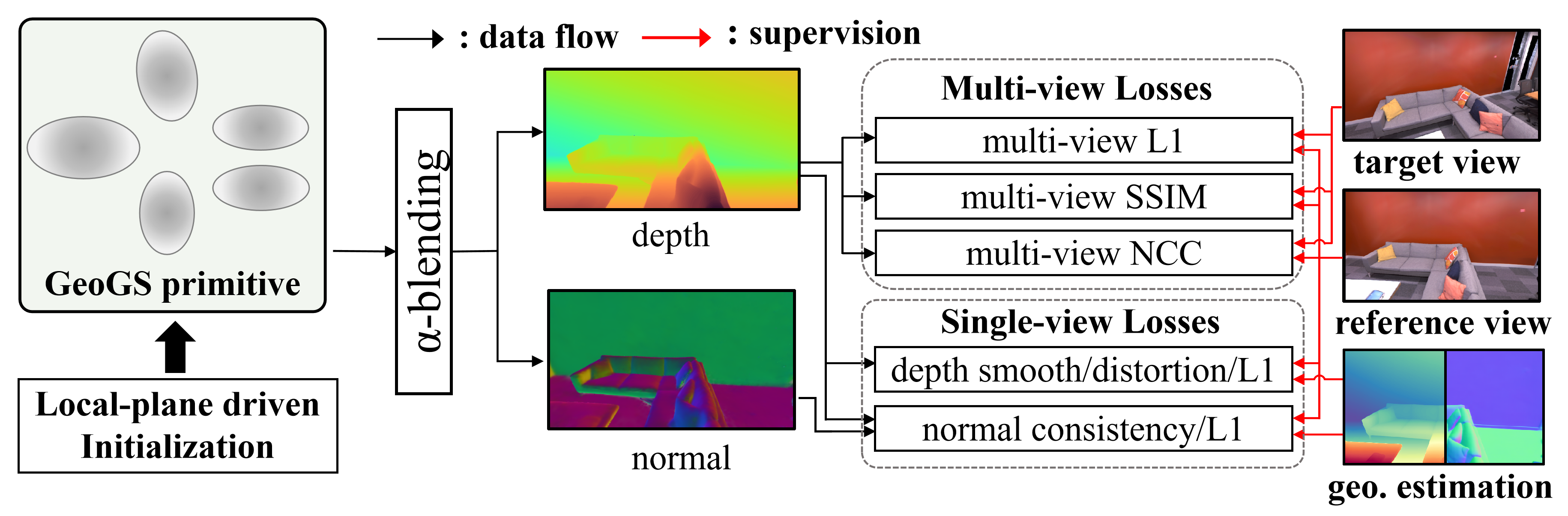
- They render depth and surface normals from the Gaussians. Depth says how far each pixel is; normals say which way a surface is facing.
- Single-view supervision:
- Depth smoothness: encourages smooth surfaces except at edges.
- Normal consistency: makes the Gaussians’ normals agree with normals computed from the rendered depth.
- Distortion penalty: discourages multiple Gaussians at very different depths from “fighting” over the same pixel.
- Optional priors: if the SLAM frontend can provide rough depth or normal estimates, they nudge the Gaussians toward those.
- Multi-view supervision:
- Even without color, they can still use the real RGB frames to check geometric consistency. They use the rendered depth from one frame to reproject pixels into a neighboring frame and compare small image patches (using L1, SSIM, and NCC). If the shape is right, the reprojected patches should look similar. This uses image consistency as a proxy to improve geometry.
Analogy: If you know how far things are and how surfaces tilt, you can check whether the shape makes sense from different camera angles by seeing if patches line up across views, even if you don’t “paint” the model.
Smart starting positions (local-plane initialization)
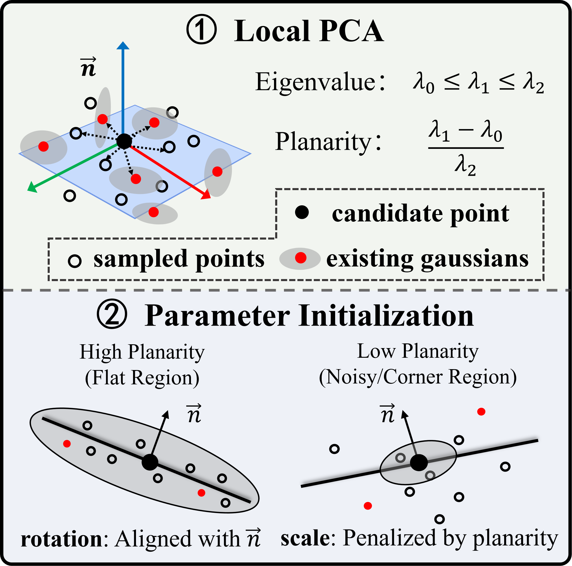
When adding new Gaussians, they don’t place them randomly. They:
- Back-project the current frame’s depth into a cloud of 3D points.
- For each candidate point, look at its neighbors and estimate a local plane (using PCA, a math tool that finds the best-fit flat surface).
- Initialize each Gaussian’s orientation to align with that plane’s normal.
- If the area isn’t very planar (uncertain geometry), they start with a smaller Gaussian so it doesn’t overreach.
Analogy: When pinning stickers onto a curved surface, you first feel the local flatness and align each sticker to fit snugly; in bumpy areas you use smaller stickers.
Keeping the map consistent after fixing past mistakes
In SLAM, you sometimes discover you’ve come back to a place you saw before (loop closure). Then you correct your camera poses to remove accumulated drift. But now your 3D map and your corrected poses may not match perfectly.
Past methods often “pull” different Gaussians in different directions based on which keyframe they were tied to. That can tear surfaces apart.
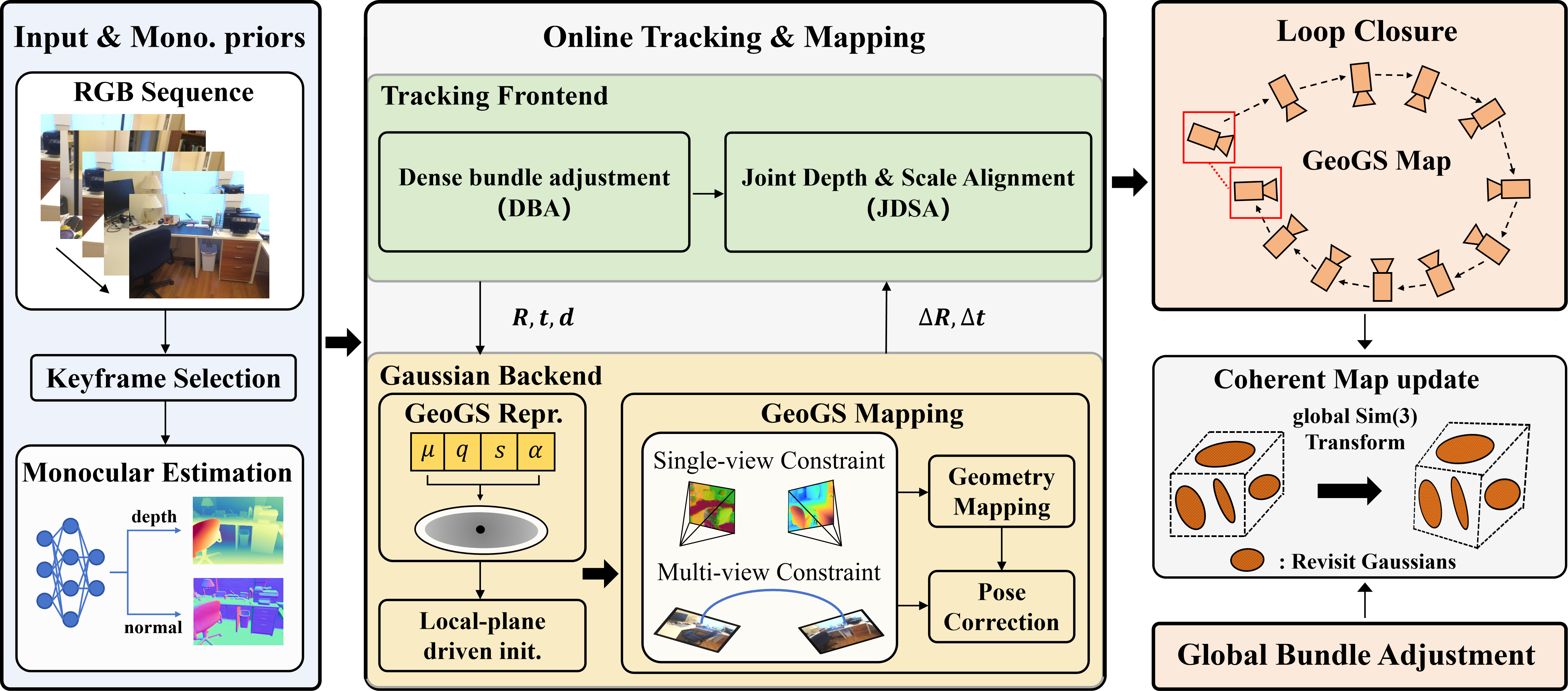
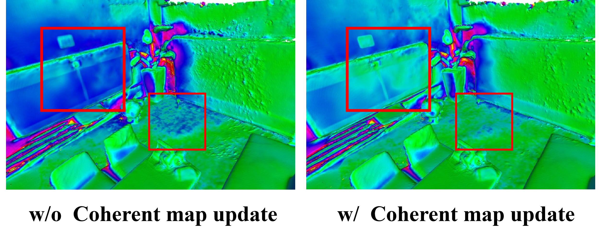
GeoGS-SLAM applies a coherent update: it estimates one unified Sim(3) transformation (a single scale-rotate-translate) for regions of revisited Gaussians and moves them together. This preserves local shape and avoids tearing.
Analogy: Instead of stretching a poster by pulling on different corners separately (which causes rips), lift and shift the whole poster as one piece.
Where this fits in a SLAM system
- Frontend (based on DROID-SLAM): picks keyframes, estimates camera poses, and produces dense depth (and optional normals) from a single camera.
- Backend (GeoGS): initializes geometry-only Gaussians, optimizes them with the losses above in a sliding window, and then does a “pose-only” refinement step (keeps the map fixed, tweaks recent camera poses using the geometry).
- Global fixes: detects loops and runs pose graph and global bundle adjustment; then uses the coherent map update to keep geometry intact.
What did they find?
Here are the main results the authors report:
- Faster, cleaner geometry: By focusing only on shape, the system converges faster and produces cleaner surfaces with fewer floating artifacts.
- Fewer parameters and primitives: Each Gaussian uses only about 17% of the usual parameters, and the final map needs far fewer Gaussians (about 28k vs roughly 100k–200k in comparable methods).
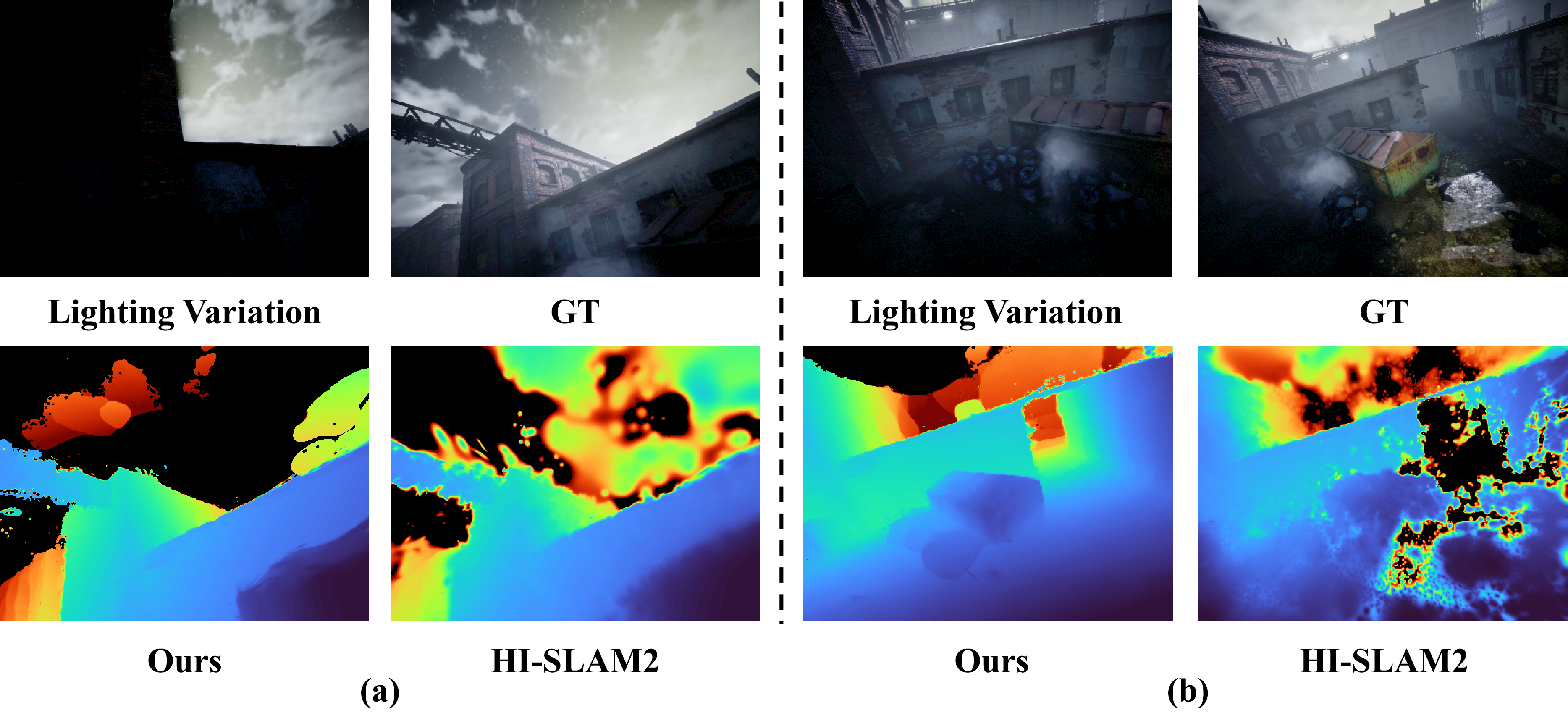
- More robust to lighting: Because it doesn’t model color, changes in illumination don’t confuse the mapping.
- Better accuracy on benchmarks:
- On Replica (a synthetic indoor benchmark), it improves mean accuracy by about 25% and completeness by about 5% compared to strong baselines.
- On ScanNet++ (a real-world dataset), it reduces Chamfer Distance (a shape error measure) by about 30%.
- Coherent map updates reduce tearing after loop closure or global optimization, preserving smooth surfaces.
Why does this matter?
For robots and AR devices, precise shape is what really counts for moving safely and understanding space. Photorealistic rendering is nice, but it adds heavy computation and can even hurt shape learning. This paper shows that:
- You can drop appearance modeling and still get excellent, even better, 3D geometry.
- The system becomes faster and more robust to lighting changes.
- The map stays consistent after global corrections because of the unified map update.
In short, GeoGS-SLAM offers a practical, efficient path to high-quality 3D mapping from a single camera, which can help in real-time navigation, drone flight, AR scene understanding, and any task where knowing the true shape of the world matters most.
Knowledge Gaps
Knowledge gaps, limitations, and open questions
Below is a concise list of specific gaps and unresolved questions that future work could address to strengthen and generalize GeoGS-SLAM.
- Geometry-only representation trade-offs
- Quantitative analysis of when a geometry-only model underfits complex, highly curved, or thin structures versus appearance-coupled models (e.g., QGS or mixed primitives). What scene characteristics require reintroducing limited appearance terms or higher-order geometry?
- Impact of using planar disks (2DGS-style) on curved surfaces and grazing-angle views: how many primitives are needed to approximate curvature, and when does model compactness degrade?
- Opacity and occupancy modeling
- Absence of explicit regularization on opacity α may permit semi-transparent “floating” geometry; investigate sparsity/entropy priors, occupancy constraints, or learned α schedules to prevent depth layering artifacts.
- Failure modes where depth distortion loss is insufficient to avoid multi-surface blending; need diagnostics and corrective strategies.
- Multi-view photometric supervision without appearance modeling
- Despite removing SH, the method still relies on photometric consistency (L1/SSIM/NCC) across views; robustness to exposure/white-balance changes, HDR, rolling shutter, and severe illumination variation is not analyzed. Can illumination-invariant metrics or learned robust photometric terms improve stability?
- Sensitivity to low-texture/repetitive patterns and small-baseline settings where reprojection-based photometric cues become ambiguous; explore feature-level or gradient-based alternatives.
- Normal and depth priors from pretrained networks
- Dependence on monocular priors (OmniData) introduces domain-shift risks (e.g., outdoor scenes, specular/translucent materials). What is the performance drop across domains, and can uncertainty-aware weighting mitigate harmful priors?
- Normal ambiguity (sign flips) and scale inconsistency in monocular depth priors are not discussed; explicit handling and calibration procedures are missing.
- Initialization and hyperparameter sensitivity
- The local-plane PCA initialization requires choices for KNN size, planarity threshold, and scale reduction factor (×10); a sensitivity analysis and guidelines for different scene types (indoor/outdoor, structured/unstructured) are absent.
- How to adapt initialization in highly non-planar or cluttered regions where PCA planarity is unreliable? Consider learned or multi-hypothesis initialization.
- Pose-only refinement coupling with the frontend
- Stability of alternating optimization (frontend DBA vs. backend pose-only refinement) is not analyzed; potential oscillations, gauge inconsistencies, or drift reintroduction when writing back poses are open issues.
- Effect on DROID-SLAM’s internal consistency (pose–depth coupling) when only poses are updated and depths/states remain fixed; criteria for safe integration are not fully specified.
- Coherent map update after loop closure/global BA
- The region definition and estimation procedure for the “unified Sim(3) per region” update are not provided (segmentation of revisited Gaussians, region overlap handling, smoothness across region boundaries, and outlier rejection).
- Limitations of piecewise-Sim(3) corrections in scenes where drift is spatially non-uniform or requires non-rigid deformations; investigate as-rigid-as-possible warps or continuous deformation fields with regularization.
- Runtime and latency of the coherent update are not reported; trade-offs vs. retraining or per-anchor propagation are unclear.
- Scalability and long-term mapping
- Memory/runtime scaling with sequence length, map size, and resolution is not characterized (e.g., thousands of keyframes, large buildings, or city blocks). Is submap management or hierarchical pruning needed to avoid catastrophic forgetting beyond two historical frames?
- Catastrophic forgetting mitigation via two historical keyframes may be insufficient for very long sequences; quantify degradation and explore replay or priority-based sampling.
- Dynamic and non-Lambertian scenes
- The method assumes static, Lambertian scenes; handling of moving objects, specularities, transparency, and reflections (which break photometric/geometry assumptions) is not addressed. What outlier detection or dynamic masking strategies are effective?
- Dataset breadth and generalization
- Evaluations focus on Replica and ScanNet++; performance on outdoor, wide-baseline, low-light, and high dynamic range environments remains unknown. Benchmarks on KITTI, ETH3D, or Tanks and Temples would clarify generalization.
- Absolute scale recovery in monocular settings is not guaranteed; quantify metric scale drift and the reliance on Sim(3) loops or external priors to recover scale for robotics tasks.
- Numerical and rendering details
- Rendered normal is computed as a weighted sum of Gaussian normals without explicit re-normalization; analyze the impact on normal accuracy and stability of normal-based losses.
- Occlusion mask threshold τ and bilinear sampling choices may mis-handle thin structures and depth discontinuities; explore soft visibility, z-buffer-like checks, or rasterization-aware occlusion reasoning.
- Calibration and sensor effects
- Effects of camera intrinsics uncertainties, lens distortion, rolling shutter, and temporal exposure changes are not discussed; calibration-robust training or online calibration refinement could be important for real-world deployment.
- Theoretical guarantees and convergence
- No analysis of convergence properties, basin of attraction, or conditions under which geometry-only optimization is well-posed; formalizing identifiability with the proposed losses would be valuable.
- Failure case taxonomy (e.g., planar degeneracy, low parallax, textureless scenes) and automatic detection/mitigation strategies are not provided.
- Integration with higher-level tasks
- The geometry-only map lacks appearance and semantics; open question: how to attach lightweight appearance/semantic layers on demand without sacrificing mapping speed or geometric fidelity.
- Path planning and obstacle avoidance interfaces (mesh extraction, watertightness, signed distance fields) are not specified; evaluate conversion quality and computational cost for downstream robotics tasks.
- Reproducibility and ablations
- Missing ablations on the contribution of each loss term, the local-plane initialization, window size, and historical keyframe selection; provide hyperparameter ranges and decision rules for practitioners.
- Runtime breakdown (frontend vs. backend vs. loop closure vs. map update) and hardware dependencies are not reported; real-time guarantees across different GPUs/CPUs remain unclear.
Practical Applications
Immediate Applications
Below are actionable use cases that can be deployed with modest engineering effort using the paper’s contributions (GeoGS primitives, single-/multi-view geometry supervision without appearance, local-plane initialization, and coherent Sim(3) map updates).
- Robotics: real-time indoor navigation and obstacle avoidance
- Sector: robotics, logistics, retail, manufacturing, healthcare
- What to do: Replace appearance-coupled 3DGS or NeRF-style mappers with GeoGS-SLAM to build dense geometry maps for autonomous mobile robots (AMRs), service robots, and mobile manipulators.
- Why it fits: Geometry-only modeling yields fewer parameters and primitives, faster convergence, and robustness to illumination changes (e.g., flickering lights, day/night shifts).
- Tools/workflows: ROS2 node wrapping GeoGS-SLAM; conversion of Gaussian maps to occupancy grids, ESDFs, or meshes for planners (Nav2, MoveIt, Isaac); coherent Sim(3) map updates to avoid “tearing” after loop closure during long shifts.
- Assumptions/dependencies: Mostly static scenes; monocular camera with known intrinsics; sufficient parallax and texture; GPU-capable edge computer (e.g., Jetson Orin); reliable loop detection or BA; scale observability managed via Sim(3)/priors.
- Drone-based indoor inspection and mapping
- Sector: energy, mining, AEC (architecture–engineering–construction), facility management
- What to do: Deploy GeoGS-SLAM on indoor UAVs for tunnel/plant/warehouse scans where lighting is poor or inconsistent.
- Why it fits: Geometry-only splats improve robustness to illumination; fewer primitives enable faster online mapping on constrained UAV compute.
- Tools/workflows: Onboard SLAM with offboard mesh export for inspection reports; coherent map updates prevent local discontinuities after loop closures in long flights.
- Assumptions/dependencies: Predominantly static environments; good pose-graph connectivity; onboard GPU; careful exposure control even if appearance isn’t modeled (multi-view photometric checks still use images).
- AR/VR indoor mapping for spatial anchoring and occlusion
- Sector: software, mobile, XR
- What to do: Use GeoGS-SLAM to build on-device, privacy-preserving geometric maps for AR anchoring, occlusion, and scene understanding without storing appearance/texture.
- Why it fits: No appearance parameters reduces data footprint and PII exposure; illumination invariance benefits mobile AR in variable lighting.
- Tools/workflows: Unity/Unreal plugins that import geometry-only Gaussian maps; real-time mesh extraction for physics/occlusion; relocalization against geometry maps; on-device processing to avoid cloud uploads.
- Assumptions/dependencies: Mobile GPU/NPUs; camera calibration; robust relocalization pipeline; legal/privacy policies favor geometry-only storage.
- Construction progress and facility scanning using monocular cameras
- Sector: AEC, digital twins, property management
- What to do: Rapid as-built mapping with a single RGB camera for progress tracking and BIM coordination where LiDAR is unavailable.
- Why it fits: Faster convergence and fewer primitives reduce capture-to-insight latency; coherent updates maintain map integrity after long loops across floors/areas.
- Tools/workflows: Deploy on handheld rigs; export mesh or point-based geometry; compare against BIM; progress dashboards.
- Assumptions/dependencies: Adequate parallax; texture-rich scenes (rebar/concrete/fixtures); metric scaling via known baselines or Sim(3) constraints.
- Consumer robot vacuums and home robots
- Sector: consumer robotics, smart home
- What to do: Upgrade mapping stack to GeoGS-SLAM for more reliable mapping in low-light or mixed lighting (e.g., sunrise/sunset, lamps).
- Why it fits: Geometry-only reduces sensitivity to appearance changes; coherent map updates prevent discontinuities when the robot revisits rooms.
- Tools/workflows: Onboard monocular camera; occupancy map generation; room segmentation from geometry.
- Assumptions/dependencies: Mostly static scenes; sufficient features on floors/walls; cost-optimized GPU or dedicated accelerator.
- Privacy-preserving indoor navigation for assistive technologies
- Sector: healthcare, accessibility
- What to do: Build wearable or handheld navigation aids that construct geometry-only maps for wayfinding without storing identifiable imagery.
- Why it fits: No SH/color modeling minimizes PII; robust geometry under lighting changes improves reliability in homes/hospitals.
- Tools/workflows: On-device SLAM; audio/haptic guidance; cloudless storage of geometry maps.
- Assumptions/dependencies: Static or slow-moving environments; GPU-capable mobile device; compliance with medical privacy standards if used clinically.
- Multi-session map maintenance in enterprises
- Sector: robotics operations, facilities, retail
- What to do: Maintain persistent facility maps that are continuously corrected with loop closures, using the coherent Sim(3) region update to avoid map tearing.
- Why it fits: Immediate map consistency without retraining; stable surfaces after global BA aid re-use across shifts and fleets.
- Tools/workflows: Map servers pushing coherent updates; robot fleet relocalization; change detection on top of stable geometry.
- Assumptions/dependencies: Reliable loop detection; versioned map storage; multi-robot synchronization.
- Academic and teaching use
- Sector: academia
- What to do: Use GeoGS-SLAM as a research baseline for geometry-centric SLAM, ablation studies, and teaching modules on explicit differentiable rendering.
- Why it fits: Clear parameterization; strong geometry metrics; robust mapping benchmarks.
- Tools/workflows: Open-source code; datasets (Replica, ScanNet++); curriculum modules on geometry-only representations.
- Assumptions/dependencies: GPU access; familiarity with DROID-SLAM and differentiable rasterization.
- Policy and compliance pilots for privacy-first spatial data
- Sector: public policy, security, compliance
- What to do: Pilot geometry-only mapping in offices/public buildings to evaluate reduced privacy risk vs. photorealistic reconstructions.
- Why it fits: No appearance modeling minimizes faces/logos; smaller data footprint eases retention policies.
- Tools/workflows: Risk assessments; data governance frameworks distinguishing geometry from appearance; procurement language for privacy-preserving SLAM.
- Assumptions/dependencies: Legal acceptance of geometry-only data; clear retention and access control policies.
Long-Term Applications
These opportunities are plausible but require further research, scaling, or engineering (e.g., robustness to dynamics, outdoor scale, sensor fusion, mobile optimization).
- Large-scale multi-robot mapping with coherent, drift-free updates
- Sector: logistics, warehousing, security
- Vision: Combine GeoGS-SLAM on each robot with centralized coherent Sim(3) region updates to merge and maintain a single facility-scale map without tearing.
- What’s needed: Robust cross-robot loop closure; scalable region selection for Sim(3) updates; conflict resolution; bandwidth-efficient map deltas.
- City-scale, privacy-preserving crowd-sourced mapping
- Sector: software, mapping, smart cities
- Vision: Phones capture geometry-only maps of public indoor spaces (malls, stations) that aggregate into an “AR geomap” for occlusion and relocalization.
- What’s needed: Mobile-friendly rasterization kernels; relocalization at scale; map compression/streaming; handling dynamics and glass/reflective surfaces; governance for opt-in data collection.
- GPS-denied vehicle navigation in parking structures and campuses
- Sector: automotive, micromobility
- Vision: Monocular geometry-only SLAM for low-texture, variable lighting environments (underground parking).
- What’s needed: Sensor fusion (IMU, wheel odometry, ultra-wideband) for scale/stability; robustness to repetitive patterns; illumination-agnostic photometric checks; safety certification.
- Disaster response and low-visibility mapping with alternative sensors
- Sector: public safety, defense
- Vision: Extend GeoGS with event/thermal cameras for smoke/dust, supporting rapid 3D mapping with minimal visibility.
- What’s needed: New multi-view supervision compatible with thermal/event modalities; cross-modal calibration; dynamic scene handling; ruggedized hardware acceleration.
- Persistent AR cloud replacement with geometry-first maps
- Sector: XR platforms
- Vision: Replace texture-heavy “AR clouds” with lightweight, privacy-safe geometry-only maps for occlusion, anchoring, and shared experiences.
- What’s needed: Standardized geometry map formats; relocalization APIs; cross-device synchronization; authoring tools in game engines; edge caching.
- Surgical and clinical AR where privacy is critical
- Sector: healthcare
- Vision: Geometry-only mapping of operating rooms for instrument tracking and spatial guidance without storing imagery.
- What’s needed: Regulatory approval; sterile hardware deployment; guaranteed real-time performance and accuracy; dynamic human motion handling.
- Precision metrology and surveying with monocular rigs
- Sector: insurance, real estate, AEC
- Vision: Metric-accurate room/facility measurements from simple monocular captures.
- What’s needed: Reliable metric scale via known baselines/AprilTags/laser range finders; calibrated and temperature-compensated cameras; robust handling of specular/textureless surfaces.
- Ultra-low-power edge deployment
- Sector: embedded/IoT
- Vision: Port the differentiable rasterizer and optimization to mobile GPUs/NPUs or DSPs for always-on mapping.
- What’s needed: Kernel optimization and quantization; mixed-precision training/inference; scheduling that respects power/thermal budgets; partial offloading strategies.
- Robust dynamic-scene geometry-only SLAM
- Sector: broad (all above)
- Vision: Extend the framework with motion segmentation and dynamic object modeling to preserve static geometry while ignoring movers.
- What’s needed: Learning-based motion masks or geometric consistency tests; dynamic map layers; re-integration policies after motion ceases.
Cross-cutting assumptions and dependencies
- Static or quasi-static scenes: The method targets static geometry; dynamic objects require additional handling.
- Monocular priors and frontend quality: Accuracy depends on the pose/depth priors (e.g., DROID-SLAM, monocular depth/normal networks).
- Hardware: CUDA-capable GPU for real-time differentiable rasterization; mobile/embedded performance may require kernel optimization.
- Calibration: Accurate intrinsics/extrinsics and exposure control improve multi-view supervision stability.
- Loop closure and BA: Reliable detection and optimization are essential; coherent Sim(3) map updates reduce tearing but still assume well-identified revisits.
- Lighting and appearance: While geometry-only modeling increases robustness to illumination, multi-view photometric supervision still relies on image consistency (mitigated by SSIM/NCC).
- Scale: Monocular scale drift must be controlled via Sim(3) constraints, priors, or auxiliary sensors for metric accuracy.
- Privacy and compliance: Geometry-only maps reduce PII risk but still require governance (e.g., removal of sensitive geometry, retention policies).
Glossary
- 3D Gaussian Splatting (3DGS): An explicit 3D scene representation using collections of Gaussian primitives optimized via differentiable rendering. "3D Gaussian Splatting (3DGS) represents a scene as a collection of anisotropic Gaussian primitives ."
- alpha blending: A front-to-back compositing technique that accumulates contributions of semi-transparent elements based on opacity. "Then, 3DGS employs alpha blending to integrate alpha-weighted appearance from front to back:"
- anisotropic Gaussian: A Gaussian whose covariance differs across axes, allowing direction-dependent spread for better geometric fidelity. "3D Gaussian Splatting (3DGS) represents a scene as a collection of anisotropic Gaussian primitives"
- Bundle Adjustment (BA): A nonlinear optimization refining camera poses (and sometimes structure) jointly over many views. "Furthermore, we introduce a map update strategy for loop closure or global Bundle Adjustment (BA) that globally transforms the Gaussian map to align it with the corrected pose estimates while preserving local structural coherence"
- Chamfer Distance: A symmetric distance between two point sets used to evaluate reconstruction accuracy. "and reduces Chamfer Distance by 30% on the ScanNet++ dataset."
- covariance matrix: A matrix encoding the shape and orientation of a Gaussian’s spread in space. "where the covariance matrix can be decomposed as:"
- covisibility: The relationship indicating which frames observe overlapping regions of a scene. "a frame graph is maintained to represent the covisibility between frames."
- dense bundle adjustment (DBA): Bundle adjustment performed using dense pixel-wise constraints (e.g., flow or depth) rather than sparse features. "The initialization performs dense bundle adjustment (DBA) on the keyframes."
- differentiable rasterization: A rendering process whose outputs are differentiable with respect to scene parameters, enabling gradient-based learning. "Through explicit Gaussian-based scene representation and differentiable rasterization, 3DGS has demonstrated remarkable performance in novel view synthesis (NVS)"
- gauge freedom: The unobservable degrees of freedom (e.g., global scale, rotation, translation) in SLAM that must be fixed to obtain a unique solution. "To eliminate gauge freedom, we fix the pose of the earliest keyframe in the frame graph during this poseâonly refinement."
- K-nearest neighbors (KNN): A neighborhood selection method that picks the K closest points under a distance metric. "we construct a local neighborhood through a K-nearest neighbors (KNN) search over the union of the sampled points from the current frame and the centers of the existing Gaussians."
- level-set extraction: Recovering a surface as an iso-surface of a scalar field (e.g., where the field equals a constant). "GOF\cite{yu2024gaussian} models Gaussian opacity as a continuous field and directly recovers geometry through level-set extraction."
- Mahalanobis distance: A distance metric that accounts for covariance to weight residuals by their uncertainty. "$\|\cdot\|_{\Sigma_{ij}$ is the Mahalanobis distance weighting the error terms based on the confidence weights from the optical flow network,"
- Multi-view Stereo (MVS): Techniques that reconstruct dense 3D geometry from multiple calibrated images. "MGS-SLAM\cite{zhu2024mgs} leverages Multi-view Stereo (MVS) networks to obtain dense depth maps."
- normalized cross-correlation (NCC): A similarity measure robust to linear intensity changes, used for photometric consistency. "Based on the reprojected image , we compute L1, SSIM, and normalized cross-correlation (NCC) losses as follows:"
- novel view synthesis (NVS): Rendering unseen viewpoints of a scene from learned or reconstructed models. "3DGS has demonstrated remarkable performance in novel view synthesis (NVS) and has emerged as a promising approach for dense visual SLAM"
- pose-graph bundle adjustment (PGBA): Optimization over a graph of relative pose constraints, often including scale (Sim(3)) corrections. "When loop candidates are identified, a Sim(3)-based pose-graph bundle adjustment (PGBA) is adopted to correct pose and scale drift."
- Principal Component Analysis (PCA): A method to estimate dominant directions/planes by eigen-decomposition of local covariance, used here for surface-aligned initialization. "via Principal Component Analysis (PCA) to accelerate geometric convergence under constrained online optimization budgets."
- ray-splat intersection: Computing the intersection between a camera ray and a Gaussian “splat” primitive for accurate depth/normal rendering. "2DGS\cite{huang20242d} replaces volumetric ellipsoids with oriented planar disks and improves per-primitive depth accuracy through ray-splat intersection."
- SE(3): The group of 3D rigid transformations (rotation and translation). "and update the map by propagating the corresponding or pose correction to the associated Gaussians."
- Sim(3): The group of 3D similarity transformations (rigid motion plus uniform scale). "we model the correction as a unified Sim(3) transformation applied to regions of revisited Gaussians."
- Simultaneous Localization and Mapping (SLAM): The problem of estimating a sensor’s trajectory while building a map of the environment. "Dense visual Simultaneous Localization and Mapping (SLAM) is a fundamental problem in robotics."
- Spherical Harmonics (SH): A basis for representing direction-dependent (view-dependent) appearance on the sphere. "unlike existing 3DGS-based methods that encode scene appearance using Spherical Harmonics (SH) coefficients, GeoGS directly represents scene geometry"
- structural similarity (SSIM): A perceptual image similarity metric used in photometric losses. "the Gaussian primitives are optimized using the color rendering photometric loss via L1 and structural similarity (SSIM) terms:"
- TSDF: Truncated Signed Distance Function; a volumetric representation used for surface fusion. "KinectFusion\cite{newcombe2011kinectfusion} introduces online TSDF fusion for incremental dense reconstruction from RGB-D input,"
Collections
Sign up for free to add this paper to one or more collections.