- The paper introduces UAVLoc, a novel framework that integrates IB-based compression, TE-Align temporal alignment, and state-space regression for real-time UAV localization.
- It employs dynamic fusion methods like MADW and MICA to effectively combine data from cameras, LiDAR, and radar, even in the presence of noisy or missing inputs.
- Empirical results demonstrate significant reductions in data transmission and improved localization accuracy, meeting stringent real-time constraints on low-power edge devices.
Edge-Assisted Multimodal UAV Localization with Resource-Efficient Compression and Robust Fusion
The proliferation of UAVs in urban environments necessitates robust non-cooperative localization frameworks, especially where self-reported navigation data may be unavailable or untrustworthy. The research addresses the challenge of accurate real-time UAV localization by leveraging distributed ground-based sensing modalities—camera, LiDAR, and radar—processed collaboratively between resource-constrained edge devices and central edge servers. Key bottlenecks include computational and communication constraints at sensing nodes, heterogeneous data characteristics (sampling rates, encodings, alignments), and degradation or loss of sensory input due to environmental and hardware variability.
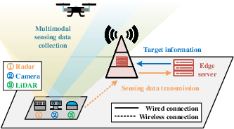
Figure 1: A distributed UAV localization involving different sensing modalities.
System Architecture and Modular Processing Pipeline
The proposed UAVLoc framework is architected to maximize localization robustness through coordinated preprocessing, compression, alignment, fusion, and regression.
At the sensing nodes (embedded devices like Raspberry Pi), modality-specific feature extraction and IB-based compression reduce communication overhead by transmitting only task-relevant latent representations. The edge server receives compressed features, performs modality alignment via TE-Align, dynamic reliability-aware fusion (MADW), and MI-driven attention (MICA), followed by Mamba-based sequence regression for joint spatial-temporal localization.
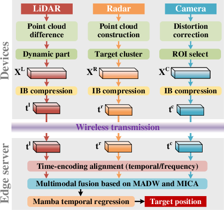
Figure 2: The architecture of the proposed UAVLoc, a multimodal UAV localization framework.
Modality-Specific Preprocessing and IB-Based Compression
Each sensing stream undergoes tailored preprocessing to distill UAV-centric features:
- LiDAR: Static background subtraction and dynamic feature isolation from spatiotemporal point clouds.
- Radar: Point cloud construction with Doppler filtering; clustering to suppress non-UAV distractors.
- Camera: Fisheye distortion correction, ROI extraction, and nonlinear mapping from world coordinates to pixel space.
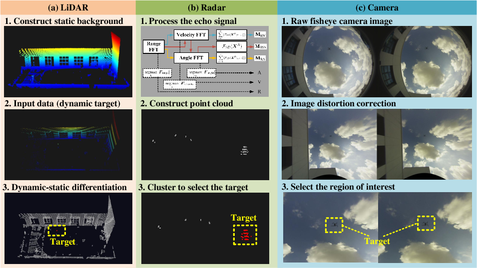
Figure 3: The key steps in the modality-specific data pre-processing for LiDAR, radar, and camera sensors, respectively.
The nonlinear transformation pipeline for camera data is encapsulated in a coordinate mapping procedure, essential for 3D-to-2D information consistency.
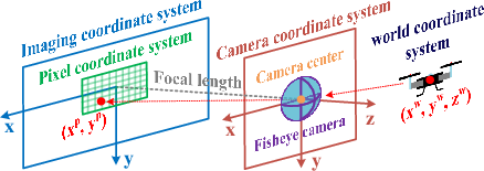
Figure 4: Derivation of the mapping between the actual UAV coordinates and the image pixel coordinates.
For all modalities, an information bottleneck-based (IB) compression module is deployed. This variational, task-adaptive encoding preserves localization-critical information while minimizing transmission rates and computational load, efficiently mapping heterogeneous features to a shared latent space.
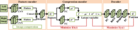
Figure 5: The architecture of the proposed compression module.
Data Alignment, Fusion, and Temporal Modeling
Temporal misalignment intrinsic to differing sensor rates is mitigated by TE-Align, standardizing feature streams onto a unified time grid with window-based pooling for frequency shaping and noise suppression.
Fusion is executed via:
- MADW: Frame-wise dynamic weighting based on learned reliability scores, effectively masking degraded or missing modalities.
- MICA: MI-inspired cross-attention for robust feature interaction, prioritizing task-relevant dependencies and minimizing noise amplification.
The fused latent sequence is input to a Mamba-based regression module, which models long-range temporal dependencies through state-space dynamics, producing trajectory-accurate UAV location estimates.
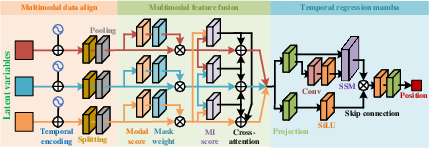
Figure 6: The data processing network for the collaborative UAV localization using multiple modal data sources.
Empirical Evaluation and Numerical Results
Data Compression Efficiency
IB-based compression delivers drastic reductions in transmitted data rates (several orders of magnitude for camera and LiDAR, substantial for radar) with negligible loss in localization accuracy.
- Camera: $63,701$ KB/s (raw) → $0.94$ KB/s (compressed, z=4)
- LiDAR: $4,685$ KB/s (raw) → $0.31$ KB/s (compressed, z=4)
- Radar: $111$ KB/s (raw) → $0.47$ KB/s (compressed, z=4)
The computational latency of the entire sensing-side pipeline, measured on Raspberry Pi 5 hardware, aligns with stringent real-time constraints (latency <0.09 s per modality), confirming feasibility for edge deployment.
The proposed preprocessing and compression modules outperform both non-preprocessed and generic MLP-based alternatives, especially at low-dimensional latent spaces, where IB-based encoding achieves near-optimal RMSE minimum.
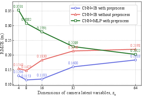
Figure 7: Localization errors using only camera modality.
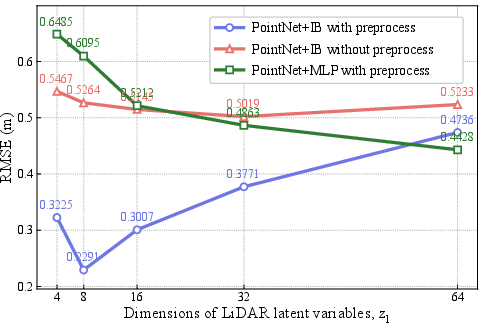
Figure 8: Localization errors using only LiDAR modality.
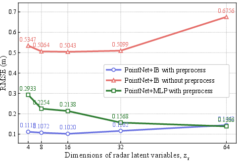
Figure 9: Localization errors using only radar modality.
Influence of Preprocessing, Alignment, and Fusion
Multimodal fusion consistently improves localization accuracy; best RMSE is attained using all modalities. The impact of data preprocessing and alignment (TE-Align) is manifest, with significant RMSE reduction compared to handcrafted temporal sampling schemes.
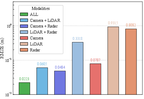
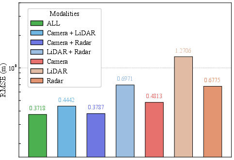
Figure 10: Localization errors with data preprocessing.
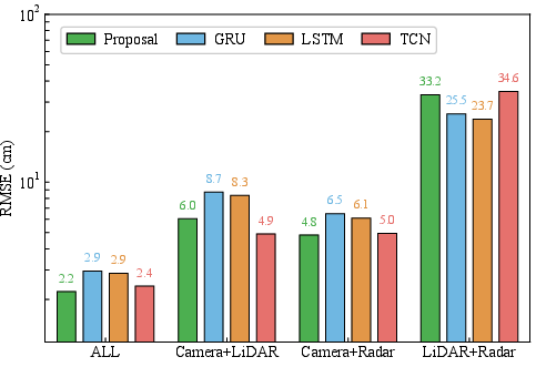
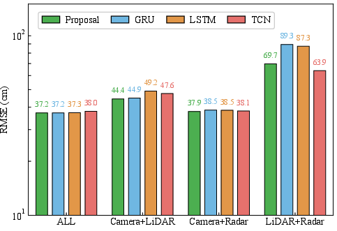
Figure 11: Localization errors with data preprocessing.
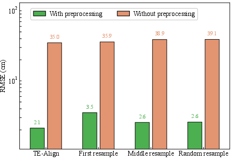
Figure 12: Localization errors under different time alignment methods.
Fusion Scheme Comparisons
Combining MADW and MICA yields superior performance in scenarios prone to high noise or missing data (notably for radar), whereas camera–LiDAR pairings are robust without additional fusion complexity.
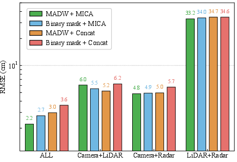
Figure 13: Localization errors for different fusion schemes.
Among tested multimodal fusion baselines (feature-level early fusion, late weighted fusion, ModDrop, HeMIS-style fusion), the proposed framework exhibits lowest localization errors, validating its architecture for dynamic, resource-constrained settings.
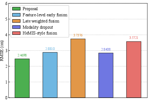
Figure 14: Localization errors for different multimodal fusion localization methods.
Communication Application
Effective UAV localization enhances mmWave relay performance by enabling beam steering, with achieved data rates near those of perfect localization, underscoring practical synergy between sensing and communications.
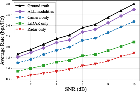
Figure 15: Achievable data rates as a function of SNR.
Theoretical and Practical Implications
The research advances external multimodal UAV localization by integrating IB compression, temporal encoding alignment, reliability-aware fusion, and MI-driven attention with scalable, resource-efficient design. Theoretical contributions include robust processing architecture for heterogeneous, degraded/missing modalities, and improved temporal regression via state-space modeling. Practically, the approach is deployable on low-power hardware with minimal latency, enabling real-time supervision of non-cooperative UAVs under adverse conditions.
Future directions involve extension to multi-target localization, fusion with additional sensing streams (e.g., microphone arrays), and large-scale collaborative sensing across multi-BS networks.
Conclusion
The presented UAVLoc framework delivers highly accurate, robust, and resource-efficient localization for non-cooperative UAVs in urban airspace. Extensive evaluation using real-world multimodal datasets confirms its superiority over baseline fusion strategies in both localization and communication relay contexts. The modular, edge-assisted architecture is suitable for real-time deployment and paves the way for innovations in collaborative multimodal sensing and autonomous airspace monitoring.