- The paper introduces a comprehensive benchmark that evaluates low-altitude UAV spatial intelligence using 4,331 real-world instances across 14 fine-grained tasks.
- It employs diverse input configurations and multimodal annotations—including paired images, video frames, and geometric data—to assess complex spatial reasoning such as aerial–ground alignment and motion analysis.
- Results show state-of-the-art vision-language models significantly lag behind human performance, emphasizing the need for domain-adaptive training and enhanced geometric grounding.
SpatialUAV: Benchmarking Spatial Intelligence for Low-Altitude UAV Perception, Collaboration, and Motion
Motivation and Context
Spatial intelligence is critical for low-altitude UAVs engaged in complex operational domains such as search and rescue, infrastructure inspection, logistics, and environmental monitoring. Existing spatial intelligence benchmarks have primarily targeted ground-level or indoor scenarios, leaving several key UAV-specific aspects underexplored—including 3D spatial reasoning, cross-view collaboration, aerial–ground alignment, scene dynamics, and diverse output formats.
SpatialUAV proposes a comprehensive diagnostic evaluation engine for UAV spatial intelligence, comprising 4,331 real-world instances across 14 fine-grained spatial reasoning tasks. The benchmark’s schema is designed to accommodate heterogeneous input configurations and answer formats, spanning single-image semantic discrimination, multi-view spatial relation, aerial–aerial collaboration, aerial–ground collaboration, and video-based motion understanding.
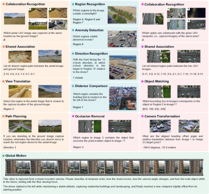
Figure 1: SpatialUAV provides representative examples from all reasoning categories, with color-coded panels denoting different evaluation settings.
Benchmark Construction and Scope
SpatialUAV’s construction pipeline integrates data curation from five diverse UAV sources, multimodal annotation procedures (including detector-assisted bounding boxes, depth maps, paired-view correspondences, trajectory metadata, and extensive manual labeling), and multistage human+model validation. The benchmark features:
- Task Diversity: 14 task types covering semantic region recognition, anomaly detection, directional estimation, distance comparison, object matching, camera transformation, path planning, occlusion removal, and motion description.
- Input Configurations: Seven input settings (single images, paired images, candidate view selection, video frames) accounting for UAV-specific occlusion, aerial–ground distortion, and cross-platform collaboration.
- Answer Formats: Nine canonical formats, including region labels, option letters, clock directions, geometric values, correspondence lists, bounding boxes, direction labels, and free-form text descriptions.
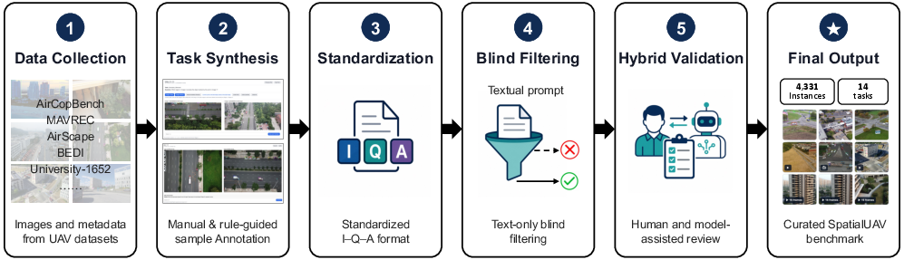
Figure 2: The construction pipeline outlines input curation, task-specific synthesis, annotation, filtering, and validation in SpatialUAV.
SpatialUAV emphasizes task-specific metric design to objectively measure spatial reasoning capabilities, employing normalized scoring for partial credit in multi-region recognition, F1 for correspondences, composite metrics for bounding boxes, acceptance thresholds for geometric values, and LLM-based semantic similarity for motion understanding.

Figure 3: Task distribution shows major reasoning groups and fine-grained categories, confirming balanced coverage in the benchmark.
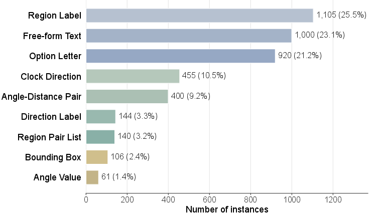
Figure 4: The answer-format histogram illustrates the prevalence and diversity of response types across the dataset's 4,331 instances.
Evaluation: Models and Results
SpatialUAV evaluates vision-LLMs (VLMs) across three categories: closed-source (GPT-5.4, Gemini-3.1-Flash, Claude-Opus-4-7), spatial-specific (SpatialVLM, VST-7B-SFT, SpaceEra, etc.), and open-source (Qwen variants, InternVL3.5 series). All models are tested under a standardized protocol, with deterministic decoding, uniform prompts, and controls for output length.
Key findings include:
- Macro Performance: Human annotators achieve 89% on average. GPT-5.4 leads model performance at 56.7%, with open-source Qwen3.6-27B at 49.5%. Random guessing yields only 14.4%.
- Task-Level Gaps: Models perform adequately on semantic discrimination and simple spatial relations but struggle markedly in cross-view association, precise geometric transformation, and motion reasoning—tasks demanding alignment of perspectives and structured outputs.
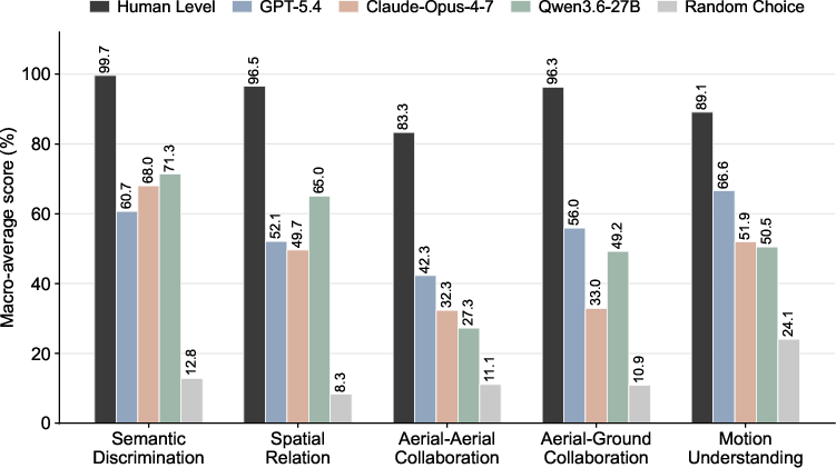
Figure 5: Macro-average scores highlight substantial model deficits in collaborative and motion-centric reasoning tasks compared to human benchmarks.
- Spatial-Specific Model Transfer: Models pretrained in spatial intelligence domains (e.g., indoor benchmarks) demonstrate poor transfer to aerial settings, with limited gains from high-resolution inputs and persistent failure in UAV-specific geometry tasks.
- Answer Format Analysis: Structured formats (region-pair lists, bounding boxes, angle–distance pairs) correspond to lower scores, reflecting the higher intrinsic difficulty of the associated tasks. Multiple-choice reformulation provides only minor improvements, indicating that spatial reasoning failures arise from task complexity, not output constraints.
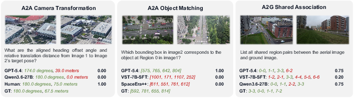
Figure 6: Qualitative cases demonstrate model successes and failures in camera transformation, object matching, and shared association tasks, with color-coding indicating correct and incorrect answer components.
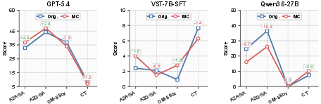
Figure 7: Answer-format ablation exposes minimal recovery in performance from switching to multiple-choice outputs, evidencing persistent reasoning challenges.
Implications and Future Directions
SpatialUAV’s empirical results underscore significant deficiencies in current VLMs addressing low-altitude UAV spatial intelligence, especially in tasks involving aerial geometry, cross-view collaboration, and temporal reasoning. The findings suggest that spatial-specific pretraining on non-UAV domains and mere answer-format adaptation remain inadequate for robust spatial reasoning in real aerial environments.
Theoretically, this points to the necessity of domain-adaptive training, explicit modeling of aerial-viewpoint distortions, improved geometric grounding mechanisms, and integration of task-specific tools (for matching, transformation, and answer synthesis) for future UAV-oriented spatial agents. Practically, SpatialUAV provides a rigorous benchmark for measuring progress and guides the development of specialized embodied models for operational UAV deployment.
Conclusion
SpatialUAV establishes a unified benchmark for low-altitude UAV spatial intelligence, encompassing diverse perception, collaboration, and motion tasks with fine-grained evaluation metrics. Extensive experiments reveal that state-of-the-art VLMs fall well short of human capabilities in UAV-specific spatial reasoning. The results indicate clear priorities for advancing spatial intelligence—via domain adaptation, geometric grounding, and targeted reasoning—beyond conventional recognition and answer-format flexibility, to address the demands of real-world aerial platforms.