- The paper introduces an open-source, event-centric pipeline that harmonizes 11 heterogeneous wildfire datasets for robust spatial and temporal analysis.
- It employs tailored techniques such as reprojection, resampling, and asynchronous temporal alignment to preserve data fidelity, achieving minimal error margins.
- The framework supports both physics-based and deep learning wildfire modeling by providing reproducible, analysis-ready outputs for simulation and decision support.
FireDataForge: An Automated Framework for Multi-Source Wildfire Data Integration
Motivation and Context
Wildfire modeling, risk assessment, and educational applications demand comprehensive integration of heterogeneous geospatial datasets. These encompass fire behavior, meteorology, vegetation, terrain, built environment, wildland-urban interface (WUI), fire history, and satellite imagery—each with distinct formats, spatial resolutions, temporal cadences, and coordinate reference systems (CRS). Manual curation and harmonization of these inputs severely restrict reproducibility and scalability, posing obstacles to robust wildfire research and operational deployment. FireDataForge directly addresses this technical burden through a unified, open-source pipeline that automates retrieval, reprojection, resampling, and metadata-rich output generation from 11 distinct data sources, centered on a specific fire event indexed by MTBS Event ID (2606.21198).
System Design and Workflow
FireDataForge implements an event-centric workflow configurable by the user for target CRS, spatial resolution, and fire event ID. The framework resolves event spatiotemporal context, retrieves source datasets, executes spatial and temporal harmonization, and outputs analysis-ready NumPy arrays with extensive embedded metadata (timestamp, units, nodata values, per-layer native resolution, attribution). Category-specific processing modules oversee ingestion and transformation of each source—e.g., FEDS perimeter tracking, VIIRS active fire radiative power mapping, HRRR meteorological field interpolation, Global Building Atlas height rasterization, and Sentinel-2 land surface translation.
Spatial harmonization leverages reprojection and resampling tailored by data type: bilinear interpolation for continuous fields, nearest-neighbor for categorical data, and area-weighted averaging for building height aggregation. Temporal alignment utilizes independent frame cursors per data source: sub-daily fire and weather observations update asynchronously, while static layers remain fixed across simulation epochs. The resultant outputs enable direct use in physics-based and ML-driven wildfire spread simulation, advanced visualization, and downstream AI analytic pipelines.
Data Integration and Processing Fidelity
FireDataForge orchestrates integration of datasets spanning perimeters and fireline snapshots (FEDS), FRP fields (VIIRS), elevation and terrain RGB (3DEP), canopy bulk density and cover (LANDFIRE), wind and humidity (HRRR), building heights (Global Building Atlas), land cover (WorldCover), leaf area index (Sentinel-2 LAI), cloudless satellite mosaics (Sentinel-2 RGB), WUI classes (Global WUI), and recent burn polygons (NIFC IFPH). Spatial resampling preserves categorical class congruity and continuous field integrity, with scale mismatches explicit in output metadata. Meta-analysis demonstrates negligible coordinate round-trip error (3.0×10⁻⁹\,m), high fidelity of FRP conservation (≤0.004% error after Gaussian splatting), elevation RMSE of $4.27$\,m, and strong categorical accuracy for land cover ($0.944$) and WUI ($0.998$) against reference aggregates.
FireDataForge was operationally validated across 8 historical fire events (CA and CO, 2013–2025), spanning diverse land cover, fuels, meteorological regimes, ignition sources, built environment contexts, and fire durations. Output grid sizes ranged from 361×388 to 1397×1448\,px (0.14–2.0M pixels) and 5–24 perimeter timesteps. With single-threaded execution on contemporary HPC nodes, event processing times ranged from $13.5$–$269.1$\,s (cold cache) and $12.7$–≤0.004%0\,s (warm cache), dominated by network I/O. No layer failures were observed over 48 timed runs. Per-event metadata and timings are publicly released for benchmarking and reproducibility.
Representative Multi-Source Output
FireDataForge’s harmonized outputs facilitate seamless visualization and inspection across all integrated layers. A representative set for the 2025 Palisades Fire illustrates composition of context imagery, terrain, vegetation/fuels, urban infrastructure, weather, and fire behavior (Figure 1).
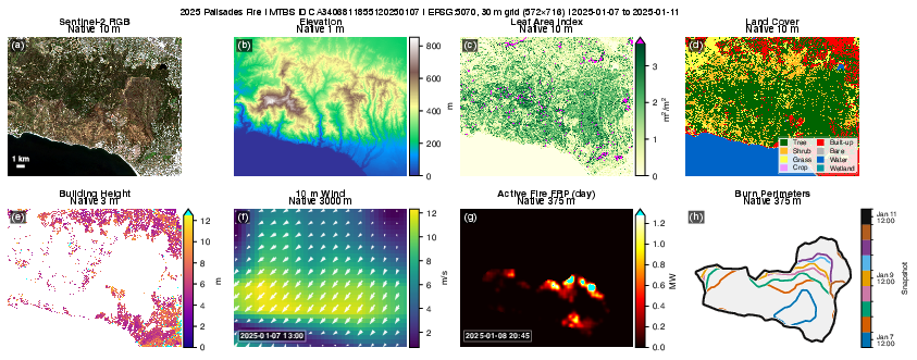
Figure 1: Representative multi-source FireDataForge output for the 2025 Palisades Fire: event-aligned context, terrain, vegetation, buildings, weather, and fire behavior, with layers sharing common extent and projection.
Comparison to Prior Work and Practical Utility
Existing retrieval libraries (e.g., GEE [gorelickGoogleEarthEngine2017], Herbie [blaylockHerbieRetrieveNumerical2026]), multimodal fusion frameworks [yuanFireRiskMultiDynamicMultimodal2025a], and curated ML datasets (BCWildfire [xuBCWildfireLongtermMultifactor2026], Next Day Wildfire Spread [huotNextDayWildfire2022], Mesogeos [kondylatosMesogeosMultipurposeDataset2023]) focus on platform-specific inputs or fixed grid/cadence outputs. FireDataForge is distinct in its on-demand event alignment, direct mapping to user-specified grids and CRSs, retention of native temporal cadence, and preservation of upstream attribution. This architecture supports reproducible cross-event benchmarking, spatiotemporal simulation, and scalable batch processing.
Numerical results highlight alignment accuracy and output fidelity. Quantitative harmonization—measured as spatial/temporal congruency and FRP conservation—demonstrates robust handling of multi-resolution and multi-modality input streams. The outputs accommodate both physics-based and deep learning approaches to fire modeling, enabling rapid assembly of training datasets, real-time simulation, and high-resolution visualization.
Implications and Future Directions
The automated preprocessing pipeline reduces barriers to reproducible fire behavior research, educational content creation, and operational modeling. Analysis-ready outputs directly support integration with frameworks such as PyTorchFire [xiaPyTorchFireGPUacceleratedWildfire2025], advanced ML architectures [zhouComparativeInterpretativeAnalysis2025, xuDeepLearningWildfire2025], and decision support platforms [altintasActionableFireModeling2025]. In practice, FireDataForge enables rapid scenario testing, model calibration, and cross-event comparative analysis with minimal manual intervention.
Theoretically, the modular design sets a foundation for expanding the scope of integrated environmental and anthropogenic data, accommodating future layers (e.g., MODIS, ERA5-Land, evacuation and sociotechnical dynamics), web-based visualization, and interoperable interfaces for real-time simulation and decision support. Such scalability is critical as modeling sophistication and application requirements increase.
Batch processing, reproducibility artifacts, and exact Event ID-based referencing establish robust conventions for national and continental-scale studies. The explicit preservation of native resolution and source attribution also facilitates rigorous downstream uncertainty quantification and bias assessment.
Conclusion
FireDataForge presents an event-centered, automated, and reproducible approach to multi-source wildfire data fusion, supporting geospatial analysis, simulation, ML, and AI applications with analysis-ready outputs. The framework demonstrates high numerical fidelity, flexible integration, and efficient performance across diverse fire contexts. Its design and open-source distribution promote large-scale, reproducible wildfire modeling, and pave the way for future advances in AI-driven fire science and operational risk management.

