- The paper proposes a quantum-inspired interferometric method that overcomes classical triangulation errors in topographic estimation.
- It introduces a topographic interferometer that leverages cross-detector correlations and balanced homodyne detection for optimal gradient extraction.
- It reveals a measurement trade-off between topographic and absolute distance estimation, achieving improved precision scaling through quantum Fisher information.
Motivation and Background
Conventional triangulation-based stereovision—canonical in both remote sensing and astronomy—focuses on absolute distance (range) estimation via parallax. This framework, though robust, exhibits an inherent limitation: its error scales quadratically with range, δZ∝Z2. However, in practical long-range, thermal, or astronomical scenarios, the topography, rather than the absolute distance, is often the more pertinent observable. In particular, when observing extended objects with passive detection (as in thermal infrared imaging or astronomical observation of thermal sources), the primary interest is in reconstructing the profile or the gradient of the target structure (i.e., its shape), not its location.
The manuscript "Quantum-inspired Topographic Stereovision" (2606.02197) scrutinizes this standard paradigm and proposes a quantum-inspired interferometric approach to overcome the classical limitations imposed by emitter-number conservation and measurement incompatibility. The method centers on optimal extraction of topographic information by leveraging cross-detector correlations, exploiting quantum measurement theory to achieve fundamentally improved error scaling compared to triangulation. This essay offers a rigorous review of the core contributions, technical framework, main results, and implications of the work.
Observable-Measurement Mismatch in Stereovision
The classical stereovision pipeline constrains itself to matching observed 2D projections (disparity) between two detectors to infer the target's 3D profile. For extended or diffuse thermal sources, this approach is fundamentally affected by two sources of anisotropy:
- Projection Anisotropy: The projected length of a segment varies across detectors, breaking the emitter-number conservation paradigm inherent to classical superresolution schemes.
- Scattering Anisotropy: Detectors have distinct perspectives with object-dependent Bidirectional Reflectance Distribution Functions (BRDF), introducing unpredictable brightness and apparent emitter-number fluctuations across views.
Conventional approaches attempt to mitigate these with spectral or spatial regularization, but do not fundamentally address the underlying information-theoretic limitations. In contrast, the paper analyzes the information-retrieval process using the language of quantum Fisher information and information regret, revealing that the optimal measurement strategy for topography (distance gradients) is incompatible with that for absolute distance, thus requiring a paradigm shift in measurement protocol.
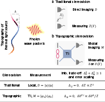
Figure 1: Quantum-inspired topographic stereovision with a topographic interferometer, where cross-detector correlations encode unique topographic information inaccessible to conventional triangulation.
Topographic Interferometer Architecture and Quantum-Optical Framework
The central technical innovation is the topographic interferometer (TI), which maps the classical parallax configuration onto a Mach-Zehnder-like interferometric apparatus. The device couples two stereo spatial modes (left and right) with a central reference (local oscillator), facilitating balanced homodyne detection (BHD). The quantum description expands the detected optical field as a statistical mixture of multi-mode single-photon wavepackets, encoding both phase and emitter-number information (corresponding to profile and tilt).
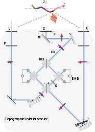
Figure 2: Schematic of the topographic interferometer with stereo spatial modes (L, R) combined at a beam splitter and a central mode (C) as the local oscillator for balanced homodyne detection, enabling full extraction of topographic information.
The technical apparatus realizes several formal advances:
- Stereo regularization: The relative apertures are tuned such that projected intensity distributions across detectors are equalized, enabling robust extraction of profile information regardless of unknown BRDF or environment-induced anisotropies.
- Cross-detector correlation exploitation: The interferometer translates emitter-number fluctuations and phase differences between detectors into measurable optical contrasts, accessed via optimal positive-operator valued measurements (POVMs).
- Quantum Fisher information saturation: By employing balanced homodyne detection and leveraging the central reference, the protocol achieves the theoretical precision limit for topographic estimation, as defined by the quantum Fisher information for the appropriate observable.
A key finding is the formally proven measurement incompatibility between optimal topographic (gradient) estimation and distance (range) estimation, rooted in quantum multiparameter estimation theory. Extracting one necessarily limits the performance of the other; optimal topographic measurements trade off distance precision.
The error scaling for classical triangulation in topography estimation is highly unfavorable, especially at large range and in the sub-Rayleigh regime, with errors dominated by diffraction, photon shot noise, and ghosting. In contrast, the topographic interferometer protocol delivers a scaling advantage:
δθTI/δθD∝b/Z
where b is the baseline, and Z is the range. The quantum-inspired protocol thus achieves substantial reduction in topographic error with increasing baseline, even as classical methods stagnate.
Bold claims in the manuscript include:
- The interferometric protocol surpasses the Rayleigh diffraction limit for passive sub-Rayleigh topographic estimation.
- Cross-detector correlations uniquely enable access to topographic information inaccessible to even spatial-mode demultiplexing (SPADE) performed separately on each detector.
- The method circumvents ghosting effects typical in thermal stereo vision without recourse to spectral resolution or stereo matching, a major practical obstacle in thermal remote sensing.
Practical and Theoretical Implications
The ability to reconstruct surface topography of extended, thermal, or diffuse objects at large range and beyond the Rayleigh limit using passive measurements opens new opportunities in fields such as astronomical imaging, remote sensing, and non-invasive thermal microscopy. The use of quantum-inspired protocols (without requiring non-classical light) allows full exploitation of the information contents in the detected photon statistics, encoding both emitter-number variation and path-phase information.
This framework also sets the stage for integration with quantum network techniques, such as entanglement-assisted interferometry and quantum repeaters, in the context of very long baseline telescopy [cf. (2606.02197), 10.1103/PhysRevLett.109.070503, 10.1038/s41586-026-10171-w]. In high-photon-number regimes, the methodology generalizes and inherits the precision scaling benefits of quantum metrology, while in the weak-photon regime it offers passive superresolution benefits with straightforward experimental validation.
Conclusion
"Quantum-inspired Topographic Stereovision" (2606.02197) rigorously demonstrates the non-optimality of triangulation for topographic extraction in distant, passive stereovision and provides a comprehensive quantum-optical solution based on interferometric measurement. By systematically analyzing scaling laws, measurement incompatibility, and practical detector architectures, the work establishes a new formalism for topographic stereovision, with direct implications for remote sensing, astronomy, and microscopy. Future directions are likely to explore further integration with quantum-enhanced detectors, extension to 2D/3D volumetric imaging, and adaptation to active quantum illumination scenarios.