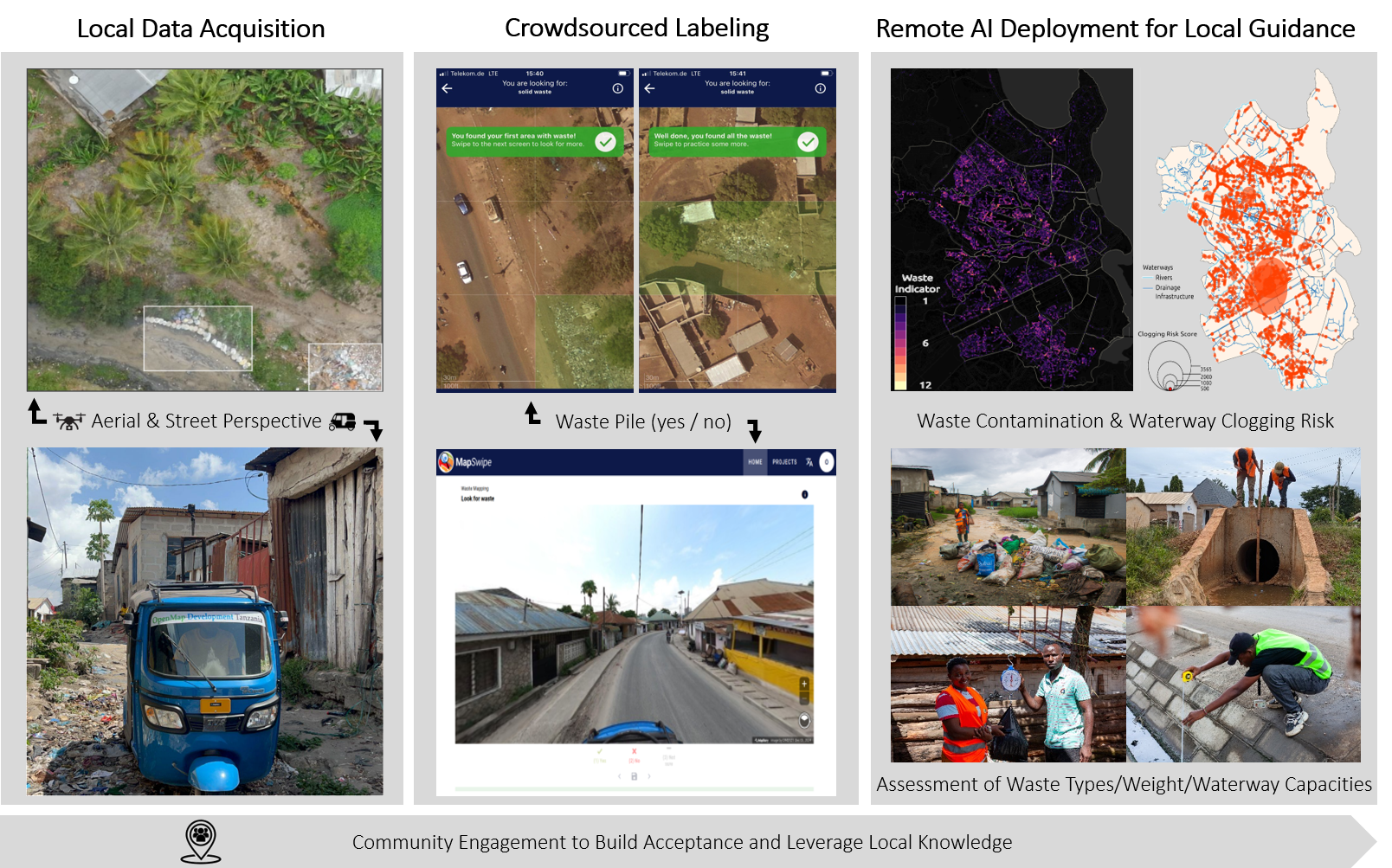
- The paper presents a multi-modal AI framework that fuses UAV and 360° street-level imagery for municipal waste detection, achieving F1 scores of 0.97 (SV) and 0.92 (UAV).
- The paper demonstrates that waste accumulates threefold near riverbeds and uses spatial clustering via Local Moran’s I to delineate urban flood risk hotspots.
- The paper emphasizes operational scalability by integrating community-based annotation and open-source data to inform targeted flood mitigation strategies.
AI-based Waste Mapping for Addressing Climate-Exacerbated Flood Risk
Introduction
Urban flooding, exacerbated by climate change, presents acute challenges in rapidly developing cities, particularly in Sub-Saharan Africa where solid waste mismanagement obstructs critical drainage infrastructure. The paper "AI-based Waste Mapping for Addressing Climate-Exacerbated Flood Risk" (2604.18151) introduces an integrated AI-powered methodology for high-resolution municipal solid waste (MSW) detection, using both UAV-based aerial and 360° street-level (SV) imagery. The research demonstrates operational deployment in Dar es Salaam, Tanzania, correlating waste accumulation with socio-economic and hydrological data to map clogging risk and inform flood mitigation strategies.
Methodology
The study employs a comprehensive pipeline that fuses multi-perspective data acquisition, locally-informed annotation, and advanced deep learning-based object detection.
A detailed overview of the workflow includes:
Results
Quantitative evaluation yields F1 scores of 0.97 (SV) and 0.92 (UAV) on annotated datasets, with UAV detections generally overpredicting in contexts complicated by reflectance, laundry, vegetation, or mosaicking errors. Waste is found to concentrate threefold more intensely adjacent to riverbeds than in surrounding urban fabric, signaling direct links to flood vulnerability. Cross-modal analysis reveals that UAV and SV detections are highly complementary: only 0.5% spatial overlap (hexagonal analysis) occurs, with UAV outperforming in backyards and SV excelling at visible street-side or partially sheltered accumulations.
Spatial clustering, using Local Moran's I, demarcates risk hot spots with strong hydrological relevance. Drainage node clogging risk is computed as the product of normalized local waste abundance and stream order, incorporating empirical and open-source basemap data for capacity estimates.
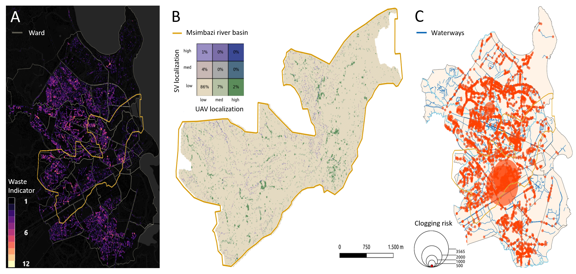
Figure 2: (A) Concentration of detected solid waste in informal central settlements, (B) minimal overlap between UAV/SV detections, and (C) high clogging risk scores at drainage nodes near Msimbazi basin.
Implications
This study presents several theoretical and practical advances:
- Operational scalability: The open, re-usable workflow bridges a gap between academic waste mapping and deployable city-wide risk analytics, overcoming the coarse granularity and limited detection fidelity of satellite-based approaches.
- Complementarity of modalities: The limited spatial concordance between UAV and SV findings empirically substantiates the necessity for multi-perspective sensing in urban waste/flood mapping.
- Contextual sensitivity: The inclusion of domain-informed, community-based annotation directly mitigates type I/II errors in AI waste detection, addressing limitations common in purely remote or automated approaches.
- Risk-index innovation: By coupling waste detection with hydrological network analysis and drainage capacity, the framework transitions from descriptive mapping to actionable risk quantification suitable for urban planning and climate adaptation.
Potential future research directions include:
- Integration of SV-derived 3D reconstructions to estimate volumetric waste load for enhanced clogging risk modeling.
- Automated domain adaptation to other cities using transfer learning or federated annotation protocols.
- Finer-grained semantic segmentation to delineate waste types, inform targeted interventions, and quantify public-health externalities.
Conclusion
The research demonstrates that AI-powered, multi-modal waste mapping can rigorously diagnose and spatialize blockage risks in flood-prone urban settings, facilitating data-driven climate adaptation and sustainable infrastructure planning. By open-sourcing both methods and datasets, the work enables further replication and upscaling in comparable cities. The coupling of technical AI advances with local knowledge and operationalized workflows offers a substantial contribution to urban resilience initiatives and geospatial intelligence for disaster risk reduction.