- The paper demonstrates that AlphaEarth embeddings significantly enhance the prediction of both shallow seismic velocities (V_S30) and deep subsurface temperature.
- It employs advanced regressors like XGBoost and neural networks to outperform traditional terrain-based models, achieving notable reductions in RMSE and MAE.
- The study establishes a scalable, physically coherent geoscientific workflow, extending foundation models to reliable subsurface inference for hazard mapping and geothermal exploration.
Subsurface Property Mapping with Google AlphaEarth Foundations
Introduction
The paper "Subsurface Property Mapping using Google AlphaEarth Foundations" (2604.14756) investigates the feasibility and performance of leveraging surface-derived foundation model embeddings, specifically AlphaEarth, for the inference of subsurface geophysical properties. The authors focus on two pivotal applications for the conterminous United States: (1) shallow seismic site characterization utilizing VS30, and (2) deep subsurface temperature reconstruction. The methodology examines whether embeddings, formed from multisource remote sensing and environmental data, can provide meaningful, physically plausible constraints for regional subsurface mapping, especially in settings where direct measurements are sparse, heterogeneous, and spatially uneven.
AlphaEarth Foundations and Surface Representation
AlphaEarth is a geospatial foundation model designed to synthesize multi-modal Earth observation inputs—optical, radar, topography, climate, hydrology, and georeferenced text—into dense 64-dimensional embedding vectors at 10 m resolution. Importantly, the embeddings characterize temporally aggregated surface state, encoding geomorphic, lithological, hydrological, vegetative, and anthropogenic attributes without direct access to subsurface measurements.
For downstream tasks, the embeddings are sampled and pooled at a 1 km scale, functioning as compact statistical summaries of coupled surface conditions. The authors treat AlphaEarth as an off-the-shelf representation, training task-specific models while keeping the embedding field fixed. This approach mirrors recent studies where AlphaEarth facilitated efficient transfer learning in sparse-label remote sensing contexts, outperforming traditional handcrafted feature engineering across domains such as biomass, crop yields, wetland vegetation, and urban air quality.
Shallow Seismic Velocity Mapping (VS30)
Motivation and Methodology
The time-averaged shear-wave velocity in the upper 30 m (VS30) is an essential attribute for site classification in earthquake engineering and hazard analysis. Traditional mapping methodologies range from geology- and relief-based heuristics to multivariate models integrating terrain, lithology, and direct seismic measurements. However, the relationship between surface properties and VS30 exhibits spatial variability and scale dependence, necessitating richer feature sets for regional mapping.
The paper implements four predictor sets for log10VS30 regression: AlphaEarth embeddings alone; log-slope plus tectonic status; AlphaEarth plus log-slope; and AlphaEarth plus log-slope plus tectonic status. Multiple regressors are evaluated, including random forest, XGBoost, and linear regression, with rigorous cross-validation and hyperparameter search. The main dataset comprises 2886 stations from the USGS compilation, filtered for quality and spatial consistency.
Embedding-informed models show marked improvement over conventional terrain-only baselines. The best-performing XGBoost model achieves RMSE = 126.1 m/s, MAE = 66.2 m/s, R2=0.5329, and Rlog2=0.6525—a 24.3% RMSE reduction and 34.4% MAE reduction relative to slope and tectonic status-only baselines. Notably, models with AlphaEarth embeddings consistently outperform terrain proxies, suggesting the latent representation captures critical aspects of site stiffness not readily encoded by slope or tectonic regime.
Feature importance analyses confirm that log-slope remains the single strongest predictor, but several embedding channels provide nonredundant, substantive contributions. Tectonic status, encoded as a binary west-east split, is less informative compared to the embedding and slope. The resulting 1 km grid national prediction surface exhibits spatial coherence and physically plausible regional contrasts, aligning with established seismic site classification boundaries.
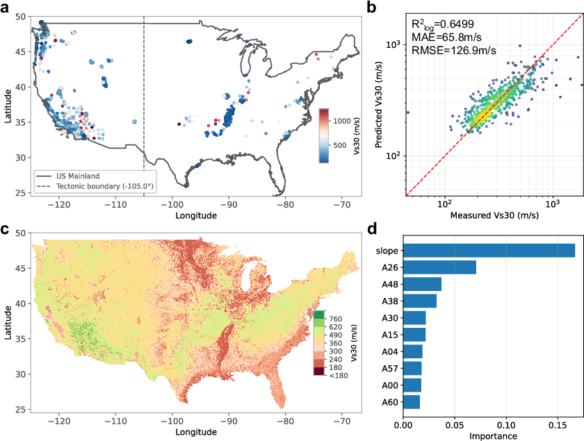
Figure 1: Overview of measured VS30 stations, prediction performance, national map, and top feature importances, demonstrating AlphaEarth's effectiveness as a landscape context encoder.
Subsurface Temperature Reconstruction
Approach
Mapping subsurface temperature at depth is critical for geothermal resource exploration, hydrocarbon assessment, and crustal thermodynamic modeling, but direct access via borehole measurements is sporadic and concentrated in energy-prospective regions. The authors construct a workflow combining AlphaEarth embeddings with a multilayer perceptron (MLP) trained on over 400,000 borehole measurements across the conterminous United States.
Each 20 km grid cell receives a 64-dimensional embedding as input, while the MLP architecture comprises three hidden layers with batch normalization and dropout to prevent overfitting. Stratified train-test splits preserve geographic diversity in performance assessment. The feature importance analysis leverages permutation testing to elucidate which embedding channels most strongly affect prediction.
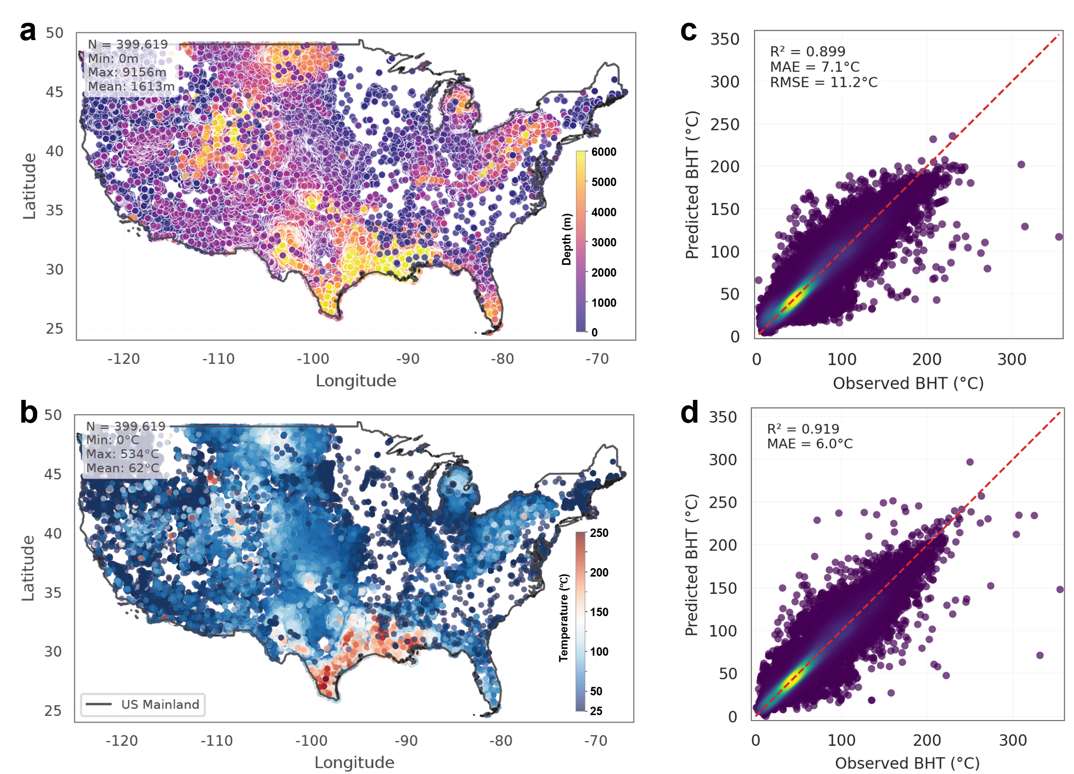
Figure 2: Distribution and depth structure of borehole measurements, and observed vs. predicted bottom-hole temperature performance with and without AlphaEarth embeddings.
Results and Interpretation
The embedding-enabled neural network achieves R2=0.919 and RMSE = 6.0∘C, substantially outperforming baseline models lacking embeddings. AlphaEarth channels collectively explain complementary variance in subsurface thermal regimes, capturing signatures from surface temperature, vegetation phenology, topography, and geology. The reconstructed maps resolve temperature gradients at the basin, fault, and regional tectonic scale, highlighting anomalies associated with volcanism and active deformation.
The predicted thermal field distinguishes the western United States—characterized by elevated heat flow and tectonic activity—from the stable cratonic eastern provinces, consistent with geophysical expectations and literature benchmarks.
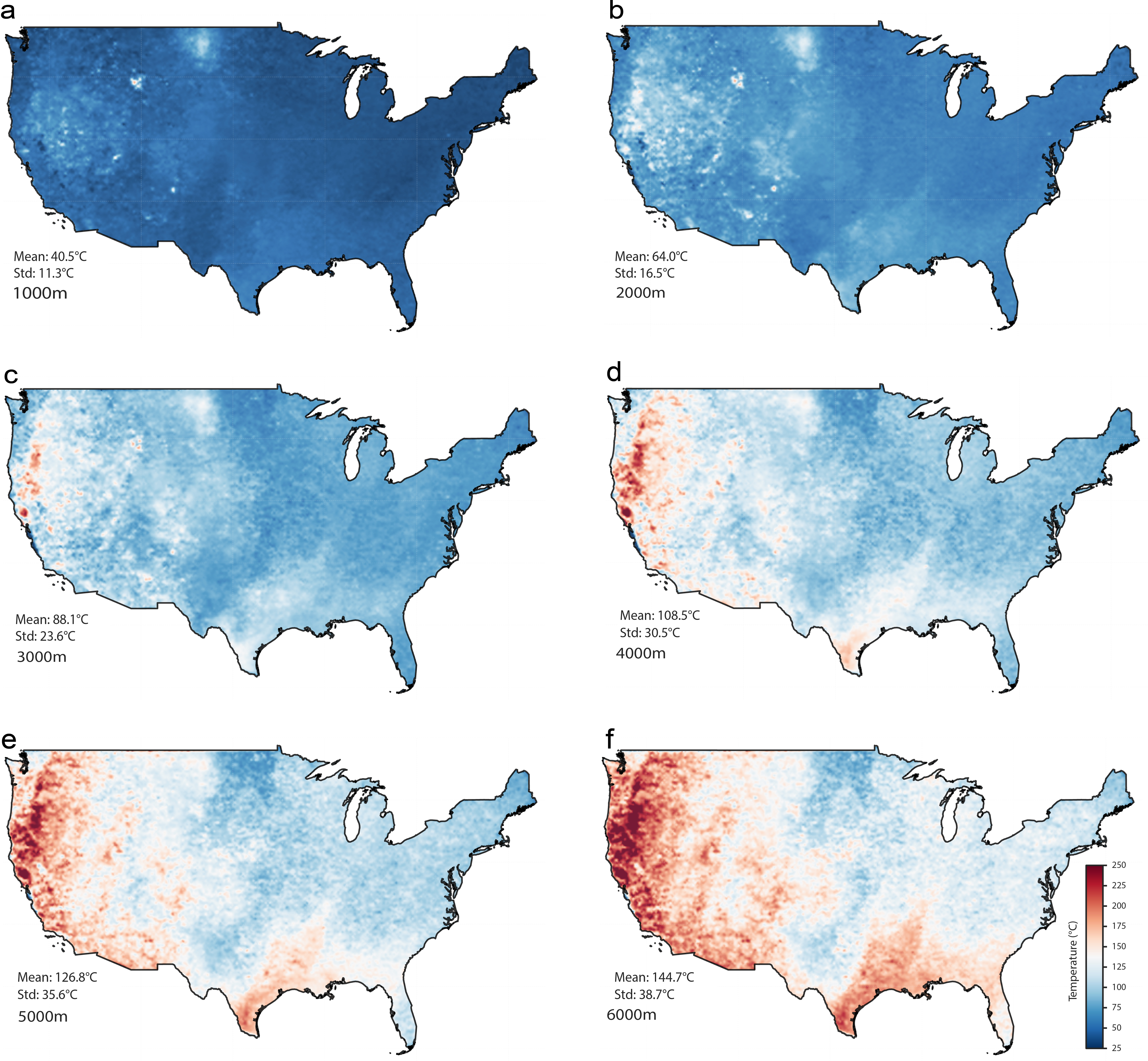
Figure 3: Continental-scale subsurface temperature map reconstructed from AlphaEarth-informed neural networks, detailing gradients from 1000m to 6000m depth.
Practical and Theoretical Implications
The results establish AlphaEarth embeddings as valuable statistical surrogates for indirect subsurface inference, particularly in settings where label coverage is sparse and uneven. For shallow seismic velocity, the embedding augments and stabilizes regression in conjunction with domain proxies, supporting scalable hazard mapping beyond regions with dense measurements. For temperature, the embedding-driven neural network provides high-resolution reconstructions suitable for exploratory geothermal assessment and basis selection for carbon storage.
The complementary findings demonstrate that foundation-model surface representations serve as generalizable inputs for a spectrum of subsurface targets, with performance gains contingent on task-specific learning architecture and feature fusion. As such, AlphaEarth and similar embedding fields can play a pivotal role in regional geoscientific workflows, reducing reliance on handcrafted features and facilitating transferability across spatially variable domains.
Limitations remain, especially regarding validation under uneven spatial sampling. The observed performance includes a component of interpolation within labeled regions, and more stringent spatial block cross-validation is required to quantify generalization and mitigate spatial leakage. The interpretability of latent embedding channels—particularly for deep thermal structure—warrants further investigation via physics-guided modeling and dimensional analysis.
Outlook and AI Perspectives
The methodology and findings reinforce the utility of foundation models in geoscientific inferential tasks. Future extensions may incorporate ensemble embedding fields, multi-scale pooling strategies, and physics-informed neural architectures to further constrain predictions and quantify uncertainty. Integration with auxiliary geophysical data (gravity, magnetics, seismicity) could enhance both shallow and deep mapping, and planetary analogs open prospects for subsurface inference on Mars, Venus, and other bodies from orbital datasets.
Model interpretability, spatial robustness, and uncertainty calibration will be central priorities for practical deployment. As foundation models become embedded in scientific pipelines, their role as shared geospatial representations will be expanded, augmenting domain-specific workflows and facilitating inter-task transfer.
Conclusion
The paper demonstrates that AlphaEarth surface embeddings yield robust, scalable improvements in subsurface property mapping across both elasticity and temperature domains. Embedding-based models outperform conventional proxies, with best results achieved via hybrid feature sets and deep learning architectures. The approach supports continental-scale inference with physically coherent outputs, offering a methodological template for foundation-model-driven geoscience. Further developments should focus on spatial validation, uncertainty quantification, and embedding interpretability to ensure reliable, explainable subsurface prediction in heterogeneous label environments.

