- The paper introduces a Neural Stochastic Process (NSP) that fuses satellite and gauge data to calibrate precipitation estimates, achieving improved accuracy and spatial coherence.
- It employs a neural process formulation combined with stochastic differential equations to model temporal dynamics, reducing RMSE by up to 4.2% over existing methods.
- NSP demonstrates computational efficiency and operational viability, setting a new benchmark with QPEBench for satellite–gauge data fusion in hydrometeorology.
Neural Stochastic Processes for Satellite Precipitation Refinement
Introduction and Problem Motivation
Robust quantitative precipitation estimation (QPE) underpins operational hydrological monitoring, severe weather forecasting, and climate impact assessment. Satellite precipitation products such as GSMaP offer global, high-frequency gridded coverage, yet intrinsic sensor limitations and retrieval assumptions lead to systematic spatial and intensity biases, especially during heavy convective events. Ground-based gauges deliver high-fidelity pointwise observations but remain spatially sparse and temporally inconsistent, rendering direct gridded calibration of satellite fields intractable. Existing QPE refinement approaches principally interpolate isolated gauge reports onto dense grids, frequently disregarding the spatio-temporal structure of the precipitation field and thus resulting in physically incoherent corrected estimates.

Figure 1: Satellite precipitation estimates have gridded bias, gauges are sparse but accurate; NSP encodes satellite estimates, elevation, and gauges with Eφ, produces a calibrated field via stochastic latent dynamics, and only uses radar for evaluation.
This paper introduces the Neural Stochastic Process (NSP), a method that synthesizes the spatial interpolation flexibility of Neural Processes (NPs) with temporally coherent, continuous-time latent dynamics via Neural Stochastic Differential Equations (Neural SDEs). NSP explicitly conditions on arbitrary, time-varying gauge configurations and satellite backgrounds, learning a temporally regularized spatial latent representation amenable to residual correction. In parallel, QPEBench is proposed as a comprehensive, ML-ready benchmark featuring five years (2021–2025) of hourly, multisource gridded QPE data over CONUS, with rigorous spatial and accuracy-focused metrics. Notably, NSP achieves superior performance across all metrics, even surpassing JAXA’s operational gauge-calibrated product (GSMaP GC), despite significantly sparser effective gauge input.
NSP Methodology
NSP leverages a context-to-target NP formulation for spatial inference, combined with a tractable SDE-based latent temporal coupling. At each hour t, four channels (satellite precipitation, elevation, sparse gauge reports, context mask) are encoded to a low-dimensional latent field zt preserving spatial topology. The decoder predicts a residual correction in log-precipitation space and uncertainty; the final field is a calibrated exponential transformation of the satellite baseline plus this residual.
Temporal consistency is enforced by regularizing consecutive latent states (zt,zt+1) using a simulation-free KL term between the encoder posterior and the Neural SDE prior, derived via Girsanov’s theorem. Critically, the decoder and full inference pass remain embarrassingly parallel across time, avoiding expensive SDE integration. This structure enables precise control over how spatial and temporal information are fused, a necessity for multi-sensor QPE fusion under non-stationary dynamics.
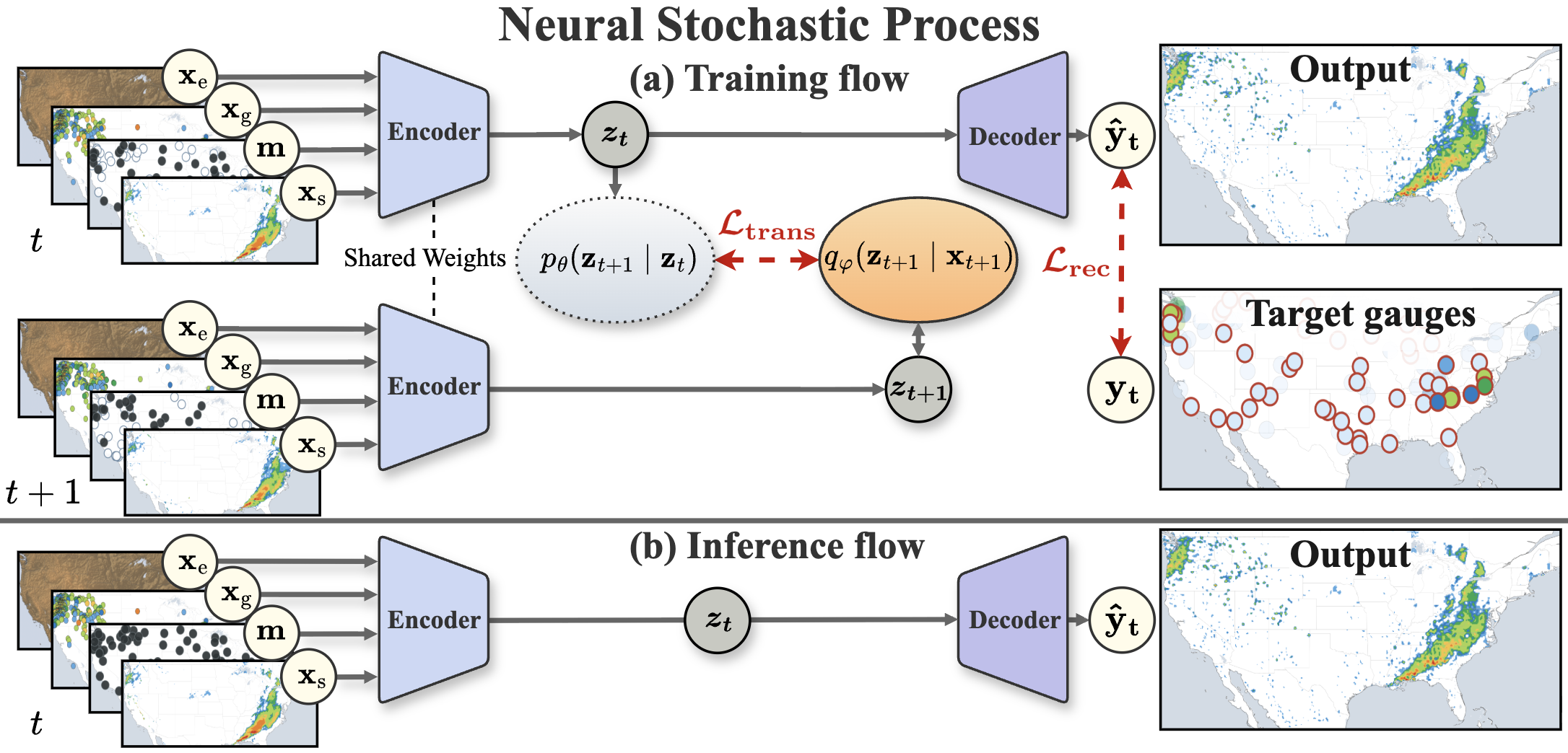
Figure 2: NSP architecture – during training, gauge observations are split into context/target for variational inference and reconstruction; at inference, all gauges are context for prediction.
The spatial latent field structure allows convolutional drift and diffusion in the Neural SDE, with uncertainty that varies by position and event, outperforming both global latent and deterministic convolutional NP baselines.
QPEBench and Evaluation Protocol
QPEBench provides the first standardized framework for satellite–gauge QPE fusion. The benchmark comprises 43,756 hourly samples over CONUS, with four synchronized data channels and six evaluation metrics, specifically:
- RMSEr, MAEr: pixel-wise error against radar reference field,
- RMSEg, MAEg: error at discrete gauge locations,
- rr,coll: collocated radar–gauge correlation for rainy points,
- FSSR: neighborhood-based Fractions Skill Score across intensity thresholds for spatial structure fidelity.
Expanding-window cross-validation ensures strict chronological separation and fair generalization assessment.
Quantitative and Qualitative Results
NSP achieves the lowest error and highest skill across all six metrics, outperforming 13 diverse baselines—geostatistical, statistical, and deep learning—plus GSMaP GC. It reduces gridded RMSE by 4.2% over GSMaP GC and gauge-level RMSE by 39.1% over the next-best approach, with a 7.6% relative improvement in spatial structure (t0). No baseline achieves competitive accuracy without sacrificing spatial realism; CNN and Transformer-based methods overfit at gauges but degrade structural skill, whereas NSP retains both.

Figure 3: NSP corrects satellite overestimation in a convective outbreak, closely matching the spatial structure of radar reference.

Figure 4: Regional zoom highlights NSP’s improved spatial localization and intensity correspondence to radar during a severe event.
Additional generalization to the Kyushu region further demonstrates domain transfer capabilities, with NSP reducing t1 by 13.1% relative to GSMaP GC and yielding a twofold gain in correlation.
Ablation analysis reveals temporal regularization via the Neural SDE transition loss is essential for preserving gridded accuracy—removing it increases pixel RMSE by 4–6%. The satellite residual connection is also critical for maintaining spatial coherence, and the heteroscedastic Gaussian likelihood is necessary for zero-inflated, heavy-tailed precipitation distributions.
Analysis and Implications
Error diagnostics show NSP’s improvements are most pronounced for moderate precipitation (up to 10 mm/h), where it achieves up to 49% lower RMSE than satellite-only fields. In high-intensity events, error remains dominated by missing, mislocalized, or ambiguous satellite inputs—an intrinsic ceiling for any satellite-gauge fusion framework employing additive or residual correction. NSP’s output is adaptively balanced: gauge corrections are concentrated in severe rainfall areas but negligible when the satellite field is reliable.
Success cases confirm that NSP can reconstruct sharp, physically plausible precipitation features (e.g., squall lines, stratiform bands) with higher fidelity than both statistical and neural competitors. Failure cases highlight the inability of any method to recover missed spatial structure when the satellite input is grossly erroneous and gauge density is insufficient, indicating a fundamental information-theoretic limitation of current QPE refinement paradigms.
Practical and Theoretical Implications
Operational deployment of NSP is feasible due to its computational efficiency (single forward pass, parallel temporal inference, low model size relative to recent weather DL systems), and the absence of SDE solver calls. The methodology advances both the practical state of satellite–gauge precipitation refinement and the theoretical integration of latent variable models and SDE-based temporal learning with arbitrary context sets.
On the theoretical side, the NSP framework demonstrates how variational objectives can unify flexible context-aware spatial encoding with continuous-time latent dynamics, without sacrificing tractability or parallelism.
Future Directions
Key limitations include underestimation during extreme rainfall due to data imbalance and residual-learning constraints. Future directions should encompass tail-aware or quantile regression losses, hierarchical or generative models capable of spatial extrapolation beyond satellite priors, and further validation in radar-sparse regions. There is substantial potential for integrating multi-modal, high-resolution sensor data in broader spatio-temporal neural process models, as well as for improving interpretability and uncertainty quantification for operational hydrometeorology.
Conclusion
This paper establishes NSP as the clear state-of-the-art for satellite-gauge QPE fusion, with a well-principled, flexible, and operationally viable framework. The work provides rigorous empirical validation on the first appropriate benchmark, clarifies the limitations of context-only fusion and residual correction, and offers a foundation for future methodological innovation across spatio-temporal data fusion in geosciences and beyond.
Reference: "Neural Stochastic Processes for Satellite Precipitation Refinement" (2604.10414).