- The paper demonstrates that meaningful spatial structure can be recovered from raw per-antenna range-Doppler radar signals without explicit angle-domain processing.
- The methodology leverages end-to-end neural architectures and visibility-aware cross-modal supervision to map radar data to BEV occupancy grids.
- Experimental results reveal that multi-TX chirp fusion and preservation of inter-antenna phase information significantly boost spatial recovery performance.
Prevailing automotive radar perception solutions rigidly separate classical signal processing from downstream learning-based tasks, typically constructing angle-domain representations (e.g., via beamforming or angle FFT) prior to any neural inference. This pipeline, while effective, raises foundational questions about the necessity of explicit angle-domain processing for geometry-centric scene reasoning. This paper challenges this traditional paradigm by probing whether meaningful spatial structure can be directly learned from pre-beamforming per-antenna range-Doppler (RD) measurements using end-to-end neural architectures. The study conducts extensive experiments on a 6-TX × 8-RX (48 virtual antennas) automotive radar, leveraging a chirp-sequence frequency-modulated continuous-wave (CS-FMCW) transmit scheme with controlled single/multi-TX aperture modulation, coupled with precise cross-modal LiDAR supervision using a visibility-aware mask.
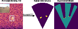
Figure 1: Despite ambiguous RD observations (near-zero Doppler), spatial structure is recoverable in BEV without explicit angle-domain processing.
Methodology
Data Representation and Architecture
The radar data is captured as complex-valued, pre-beamforming per-antenna RD tensors for each chirp type, with retainment of all inter-antenna phase information prior to any explicit angle estimation. The network processes two RD tensors (A/B chirps), each with real and imaginary channels organized as 2Nrx×R×D arrays. Inputs undergo per-chirp normalization and are processed through a receive-antenna mixing layer followed by convolutional encoding with shared weights for both chirps. Chirp feature fusion and further joint RD encoding precede a convolutional encoder-decoder that maps features to a discretized BEV occupancy grid.
Supervision: Visibility-Aware Cross-Modal Protocol
Supervision is not naively applied using all LiDAR BEV annotations. Instead, it is strictly restricted to the intersection of the radar's horizontal field-of-view and the LiDAR's observable, non-occluded BEV regions, computed using a 2D raycasting approach akin to modern occupancy prediction labelers. This restrictive, scene-dependent supervision ensures that only regions genuinely sensed by both modalities influence the loss, thereby grounding the recovered spatial structure in physically valid regions and mitigating label noise from occlusion-induced ambiguities.
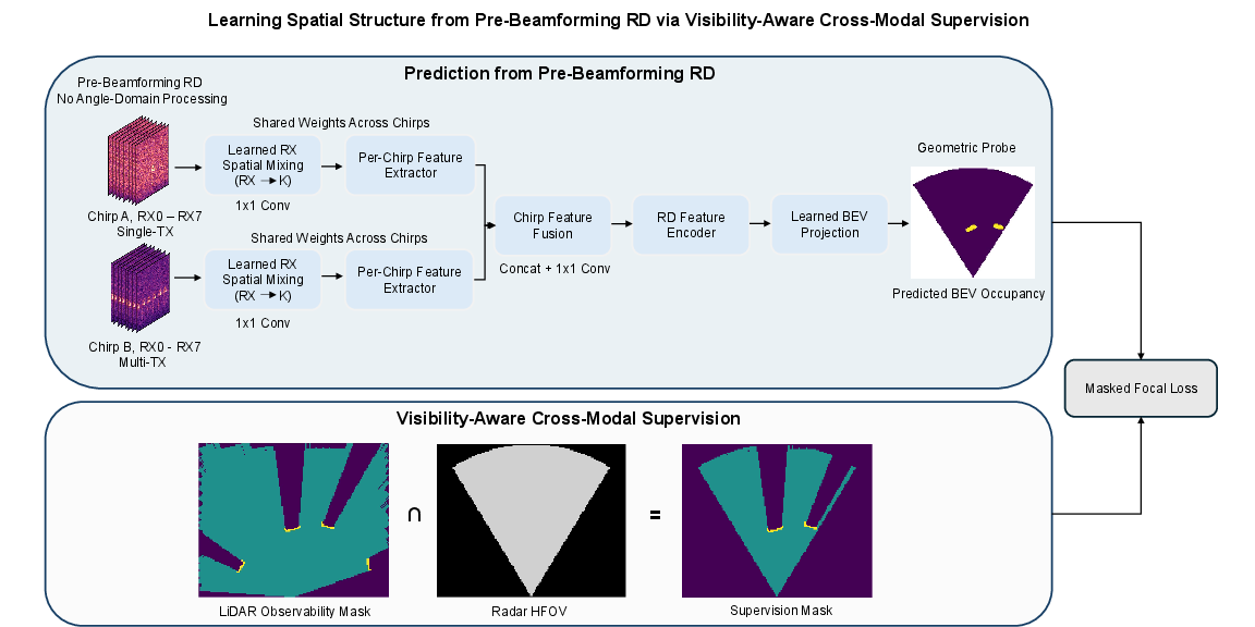
Figure 2: The proposed approach combines neural RD-to-BEV mapping (top) with explicit cross-modal, visibility-aware supervision (bottom), restricting learning and evaluation to jointly observable, physically grounded regions.
Experimental Setup
Dataset and Sensor Fusion
The collected dataset comprises over 16,600 synchronized radar-LiDAR frames obtained from automotive test track and campus road scenarios, using a Smartmicro DRVEGRD 152 radar (providing raw per-antenna RD) and a high-resolution Velodyne Alpha Prime LiDAR. All frames are spatially registered by sensor mounting geometry and temporally aligned. The radar covers a 64° HFOV and up to 65 m, with the data split at sequence level for robust evaluation.
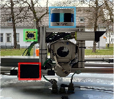
Figure 3: Sensor setup illustration detailing spatial alignment between radar (red), LiDAR (blue), and camera (green) used for cross-modal supervision and qualitative grounding.
Model Training and Evaluation
Supervision employs a masked focal loss, computed only in the joint observability mask. The BEV plane is discretized at resolutions of 0.5 m, 0.4 m, and 0.35 m. Performance metrics include Average Precision (AUPRC) and occupied-IoU within the valid mask, with additional evaluation of hallucination rates outside supervised regions. Ablation studies examine RD structure (range and Doppler collapse), chirp configuration (A-only, B-only, A+B), and output resolution sensitivity.
Key Results and Numerical Findings
Significant quantitative improvements are obtained over both a learned random prior and a physics-based range-energy projection baseline, with the best configuration (A+B chirps, full RD) achieving 0.36 AP and 0.24 IoU at 0.5 m BEV resolution, while the baseline remains below 0.06 on both metrics. Notably, even without explicit angle reconstruction, the model recovers spatially localized occupancy with a substantial reduction in hallucination rate (0.11 vs. 0.17 for baseline), indicating effective suppression of spurious predictions in unobservable regions.
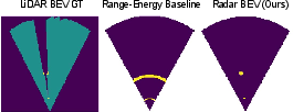
Figure 4: Comparison of LiDAR BEV ground truth, the radial range-energy baseline, and the learned model. The latter yields localized, asymmetric structure not recoverable by naive range-only projections.
Qualitative analysis confirms coherent spatial structure recoverability for large vehicles and terrain despite the lower inherent angular resolution and multipath artifacts prevalent in automotive radar. Model outputs are more spatially diffuse and "blob-like” relative to LiDAR, but maintain occupancy consistency across standard object classes and road features.
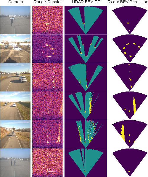
Figure 5: Qualitative BEV occupancy predictions show that radar-based models recover large-scale structures, with some responses even in LiDAR-occluded areas, likely due to different underlying physics and multipath returns.
Chirp and RD Structure Dependence
Chirp ablation reveals that multi-TX chirps (B) yield significantly higher AP (0.34) and IoU (0.23) compared to single-TX (A) (0.28/0.19), validating the importance of increased transmit aperture. Joint A+B processing outperforms either alone, evidencing that spatial structure is more robustly learned when aperture modulations are available.
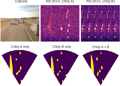
Figure 6: Chirp ablation demonstrates that multi-TX (B) signals facilitate stronger spatial recoverability than single-TX (A), with further improvements realized by fusing both.
Collapsing Doppler or, especially, range axes drastically impairs performance, with range collapse nearly eliminating any spatial recoverability (AP ≈ 0.08), underscoring the primacy of range and the complementary geometric cues offered by Doppler for this task.
Resolution, Range, and Angular Band Analysis
Predictive accuracy exhibits a monotonic decline with finer BEV resolution and increasing range, reflecting fundamental information bounds imposed by radar angular resolution, speckle, and SNR decay at longer distances. The approach is robust across most of the Azimuthal FOV, with only mild edge effects noted.
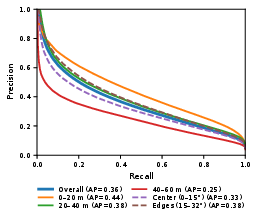
Figure 7: Precision-recall analysis across spatial bands confirms performance degradation with distance and stable behavior across azimuth sectors, consistent with physical sensing characteristics.
Theoretical and Practical Implications
This study provides strong evidence that neural architectures can exploit per-antenna phase relationships in pre-beamforming RD data, enabling end-to-end geometric learning without explicit spatial mixing, beamforming, or hand-crafted CFAR-style preprocessing. This suggests that legacy pipeline divisions between signal processing and perception are not strictly necessary for geometry-centric radar applications. Future radar perception stacks can potentially bypass angle-domain computations, reducing computational overhead, latency, and reliance on domain-specific parameter tuning.
Visibility-aware cross-modal supervision, as formalized here, also establishes a protocol by which multi-modal sensor systems can be reliably co-trained, maximizing complementary strength (i.e., radar's penetration and LiDAR's fine granularity) without over-penalizing physically inevitable differences due to sensor characteristics.
Limitations include the diffuse and less precise boundaries typical of radar inference as compared to LiDAR, with upper-bound metric ceilings inherently imposed by the lower radar angular resolution and multipath/ghosting phenomena. Scene completion and semantic understanding may benefit from fusing such end-to-end radar reasoning with higher-resolution cues from other modalities.
Conclusion
This work empirically and methodologically establishes that spatial structure for BEV occupancy can be robustly extracted from pre-beamforming per-antenna RD data via learned spatial mixing, obviating the need for explicit angle-domain radar processing. The findings have both theoretical and practical ramifications for radar representation learning: they motivate the integration of signal modeling into end-to-end frameworks, and they validate new protocols for multi-modal occupancy prediction grounded in rigorous, physics-aware supervision. Future research should extend these insights to more diverse radar hardware, broader semantic tasks, advanced sensor fusion paradigms, and potentially self-supervised or generative pretraining regimes to further exploit the latent spatial cues in raw radar signals.

