- The paper demonstrates a novel multi-agent LLM framework that integrates evolutionary code generation with structured geospatial knowledge retrieval to automate model discovery.
- It employs nested loops with code mutation, performance analysis, and domain-informed prompt generation to achieve state-of-the-art accuracy improvements in spatial interpolation and uncertainty quantification.
- Empirical results show 13–21% RMSE reduction for kriging and 17% lower interval scores for GeoCP, highlighting the practical benefits of domain-guided algorithm evolution.
GeoEvolve: Automating Geospatial Model Discovery via Multi-Agent LLMs
Overview and Motivation
GeoEvolve introduces a multi-agent LLM framework for automating geospatial model discovery, integrating evolutionary code generation with structured geospatial knowledge retrieval. The system addresses the limitations of prior LLM-driven algorithm discovery frameworks, such as AlphaEvolve, which lack domain-specific reasoning and multi-step refinement necessary for complex geospatial tasks. GeoEvolve is designed to operate in two nested loops: an inner loop for evolutionary code mutation and selection, and an outer loop for agentic control, elite retention, and domain-informed prompt generation via a geospatial knowledge base (GeoKnowRAG). This architecture enables the automatic synthesis and improvement of geospatial algorithms, grounded in established theory and empirical heuristics.
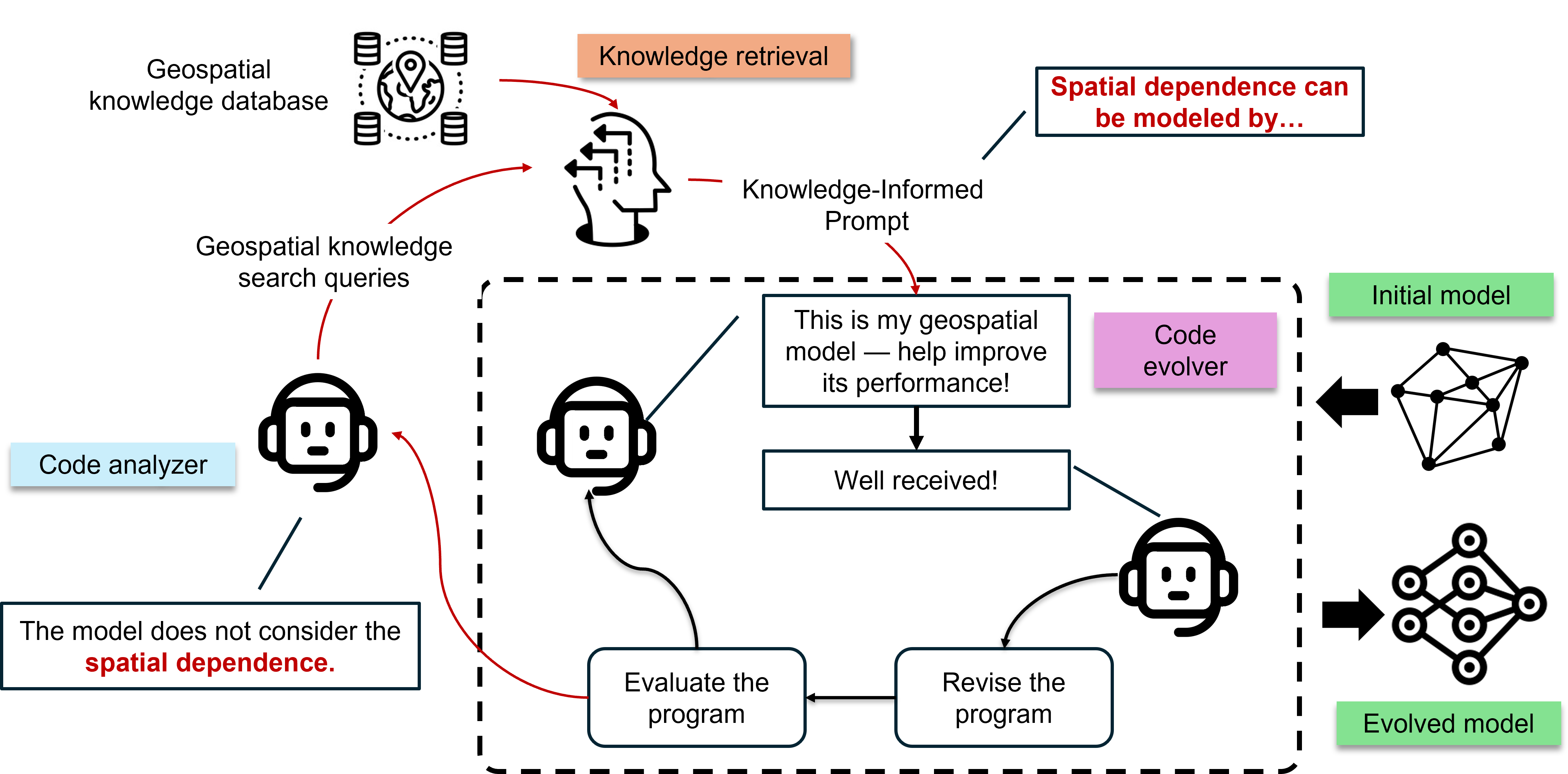
Figure 1: An illustration of the code-evolution trajectory of a geospatial model integrating domain knowledge.
System Architecture
GeoEvolve comprises four principal components: the code evolver, evolved code analyzer, geospatial knowledge retriever (GeoKnowRAG), and geo-informed prompt generator. The code evolver (OpenEvolve) autonomously generates and mutates candidate algorithms, optimizing for task-specific objectives. The evolved code analyzer interprets both code and performance metrics, identifying knowledge gaps and generating search queries for the knowledge retriever. GeoKnowRAG constructs a structured knowledge base from curated literature, Wikipedia, and GitHub repositories, employing RAG-Fusion and reciprocal rank fusion for robust retrieval. The geo-informed prompt generator synthesizes retrieved knowledge and diagnostic feedback into actionable prompts for further code evolution.
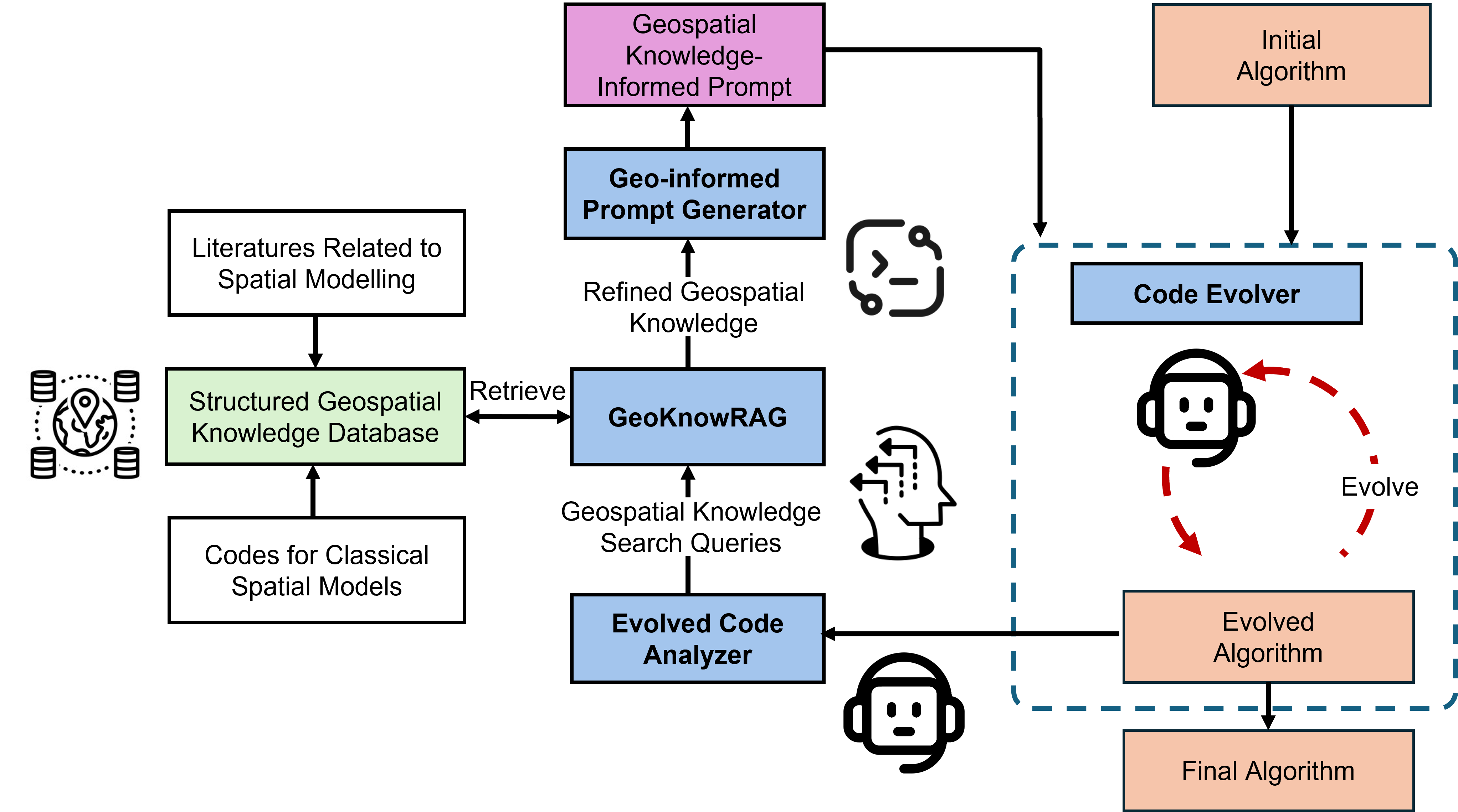
Figure 2: The workflow of GeoEvolve.
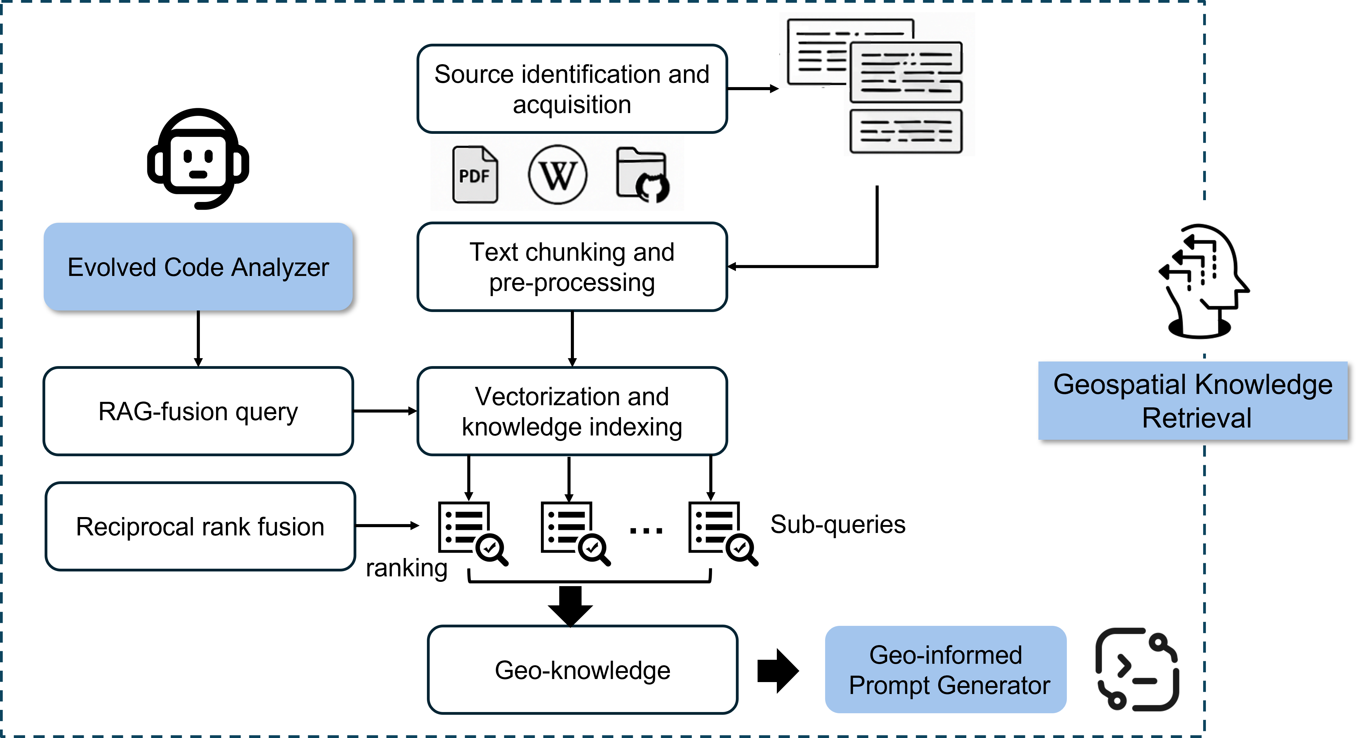
Figure 3: The workflow of GeoKnowRAG.
Evolutionary Code Generation and Knowledge-Guided Refinement
The evolutionary search is grounded in geospatial theory through the integration of domain knowledge at each outer-loop iteration. Candidate algorithms are mutated via parameter changes, operator substitutions, and structural modifications, with selection based on objective metrics (e.g., RMSE for regression, interval score for uncertainty quantification). The code analyzer and GeoKnowRAG ensure that evolution is steered toward theoretically meaningful and computationally efficient solutions, avoiding drift into non-meaningful algorithmic space.
GeoKnowRAG's knowledge base is constructed using five categories of keywords (geostatistics, spatial theory, GIScience, spatial statistics, spatial modeling), resulting in 141 documents. The retrieval process involves semantic chunking, embedding via OpenAI's text-embedding-3-small model, and storage in a Chroma vector database. Multi-angle query expansion and RRF ensure high coverage and relevance, with retrieved passages summarized into geo-informed prompts.
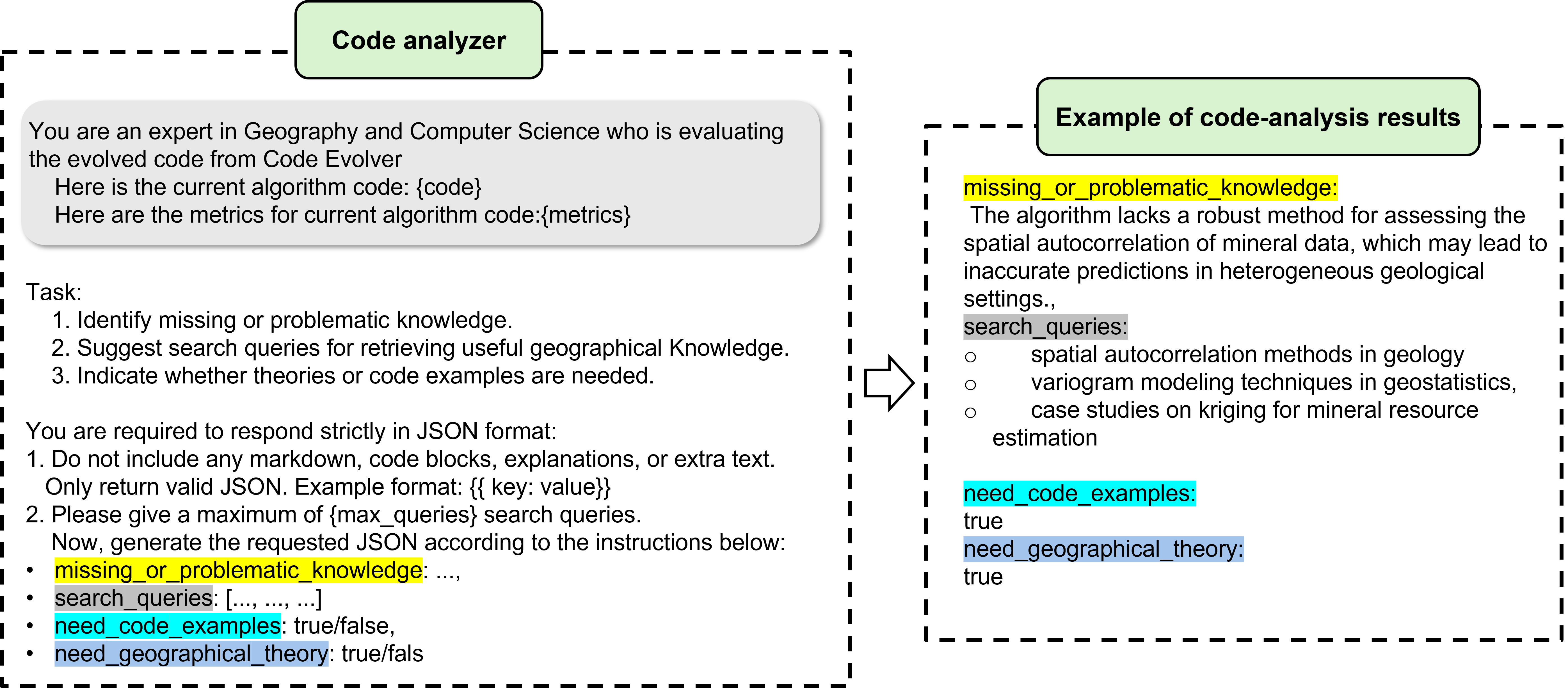
Figure 4: The template and an example of code analyzer.
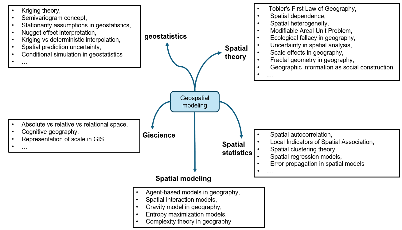
Figure 5: The keywords used for constructing geospatial knowledge database.
Experimental Evaluation
Spatial Interpolation: Kriging
GeoEvolve was evaluated on spatial interpolation using ordinary kriging as the baseline. The evolved algorithm introduces several innovations:
- Expanded variogram family (Exponential, Gaussian, Linear, Matérn) with automatic selection via AIC/BIC.
- Adaptive empirical variogram estimation using quantile/Silverman binning and trimmed means.
- Robust multi-start fitting with L1/weighted least squares and bin-based weights.
- Localized kriging with K-NN system and condition-number–aware diagonal adjustment, reducing complexity from O(n3) to O(K3).
- Adaptive log transformation with data-driven offset.
GeoEvolve–kriging achieves substantial improvements in predictive accuracy, reducing RMSE by 13–21% compared to baselines. Ablation studies confirm that domain-guided retrieval is essential for stable, high-quality evolution; removal of GeoKnowRAG degrades performance.
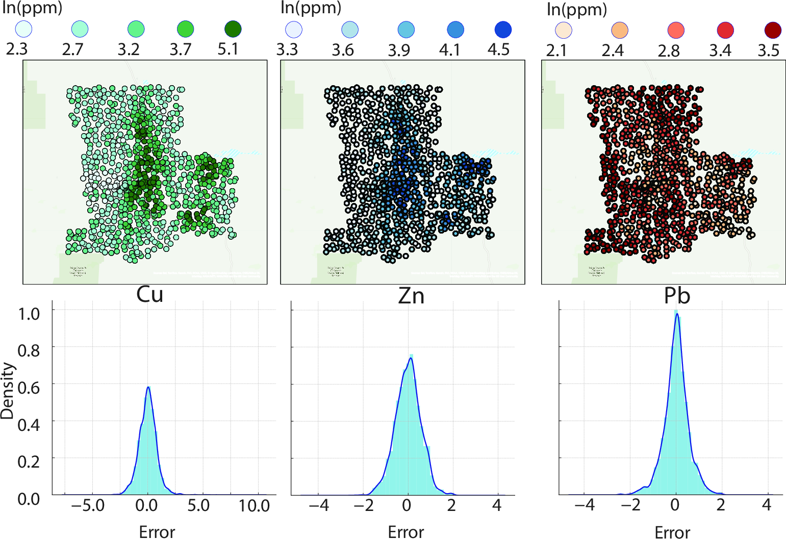
Figure 6: The spatial distribution of predicted concentrations and the error distribution of three elements, Cu, Zn, and Pb obtained from Evolved Kriging.
Spatial Uncertainty Quantification: GeoCP
GeoEvolve was further evaluated on spatial uncertainty quantification using geospatial conformal prediction (GeoCP). The evolved algorithm refines geographic weighting via adaptive bandwidth optimization and enhances weighted quantile computation with robust stepwise estimation and improved vectorization. GeoEvolve–GeoCP achieves a 17% reduction in interval score compared to the original GeoCP, with sharper and better-calibrated prediction intervals.
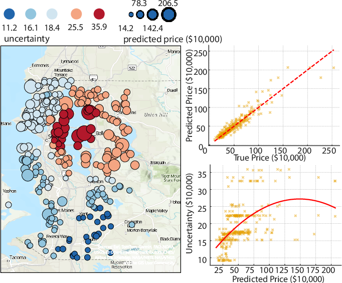
Figure 7: The spatial distribution of estimated uncertainty for houseing price prediction task in Seattle using the evolved GeoCP.
Technical Analysis and Comparative Results
GeoEvolve consistently outperforms both classical baselines and strong OpenEvolve variants. The injection of structured geospatial knowledge via GeoKnowRAG is critical; simple prompt augmentation without retrieval does not yield further gains. The evolved algorithms retain the core structure of their respective baselines but introduce domain-informed modifications that improve both accuracy and computational efficiency. For kriging, the expanded variogram family and adaptive estimation techniques stabilize parameter inference and enhance spatial prediction. For GeoCP, adaptive bandwidth and refined quantile estimation yield intervals that are both sharper and more reliable.
Implications and Future Directions
GeoEvolve demonstrates the feasibility of automated, knowledge-driven geospatial modeling, providing a scalable methodology for diverse geospatial tasks. The framework's modular design allows for extension to other domains requiring domain-specific reasoning and multi-step refinement. The results suggest that grounding evolutionary code generation in structured domain knowledge is essential for trustworthy and efficient AI-for-Science discovery. Future work should explore the integration of larger and more comprehensive knowledge bases, as well as the evaluation of GeoEvolve with different foundation models and broader geospatial tasks.
Conclusion
GeoEvolve represents a significant advancement in automated geospatial model discovery, coupling multi-agent LLM-driven evolutionary search with structured domain knowledge retrieval. The framework achieves state-of-the-art performance in spatial interpolation and uncertainty quantification, with strong empirical improvements over baselines. The critical role of domain-guided retrieval is established through ablation studies, highlighting the necessity of grounding algorithm evolution in geospatial theory. GeoEvolve provides a robust and extensible path toward scalable, knowledge-driven geospatial modeling, with broad implications for AI-driven scientific discovery and decision support.