- The paper introduces a novel workflow using CNNs for rapid damage assessment, significantly reducing response times in wildfire emergencies.
- It employs pre- and post-disaster imagery with annotated training data, achieving pixel-wise F1-scores of 0.859 for burned areas.
- The methodology fine-tunes models to regional conditions and shows scalability for broader emergency management applications.
Satellite Imagery Analysis for Damage Assessment in Emergency Situations
This essay presents an overview of a research paper focused on utilizing satellite imagery and machine learning for operational damage assessment during emergencies. The paper discusses a methodological framework designed to quickly assess damage in affected regions, using California wildfires as a case study.
Introduction to Damage Assessment
The paper begins by underscoring the criticality of rapid and accurate damage assessment following disasters such as wildfires, floods, or earthquakes. Earth Observation Systems (EOS), including satellite and aerial remote sensing, are identified as vital tools for capturing data immediately after a disaster. These systems allow for a comprehensive valuation of damages by integrating remote sensing data with statistical and ground observations. However, the traditional manual mapping processes, often employed by initiatives like UNOSAT and HOT, are time-consuming and require qualified personnel.
Existing Approaches and Limitations
Despite existing frameworks like UNOSAT and HOT mapping campaigns, current damage assessment methodologies are limited by significant time lags, especially when dealing with vast areas or scattered objects such as residential houses. Manual digitization and mapping can cause delays that impact relief efforts.
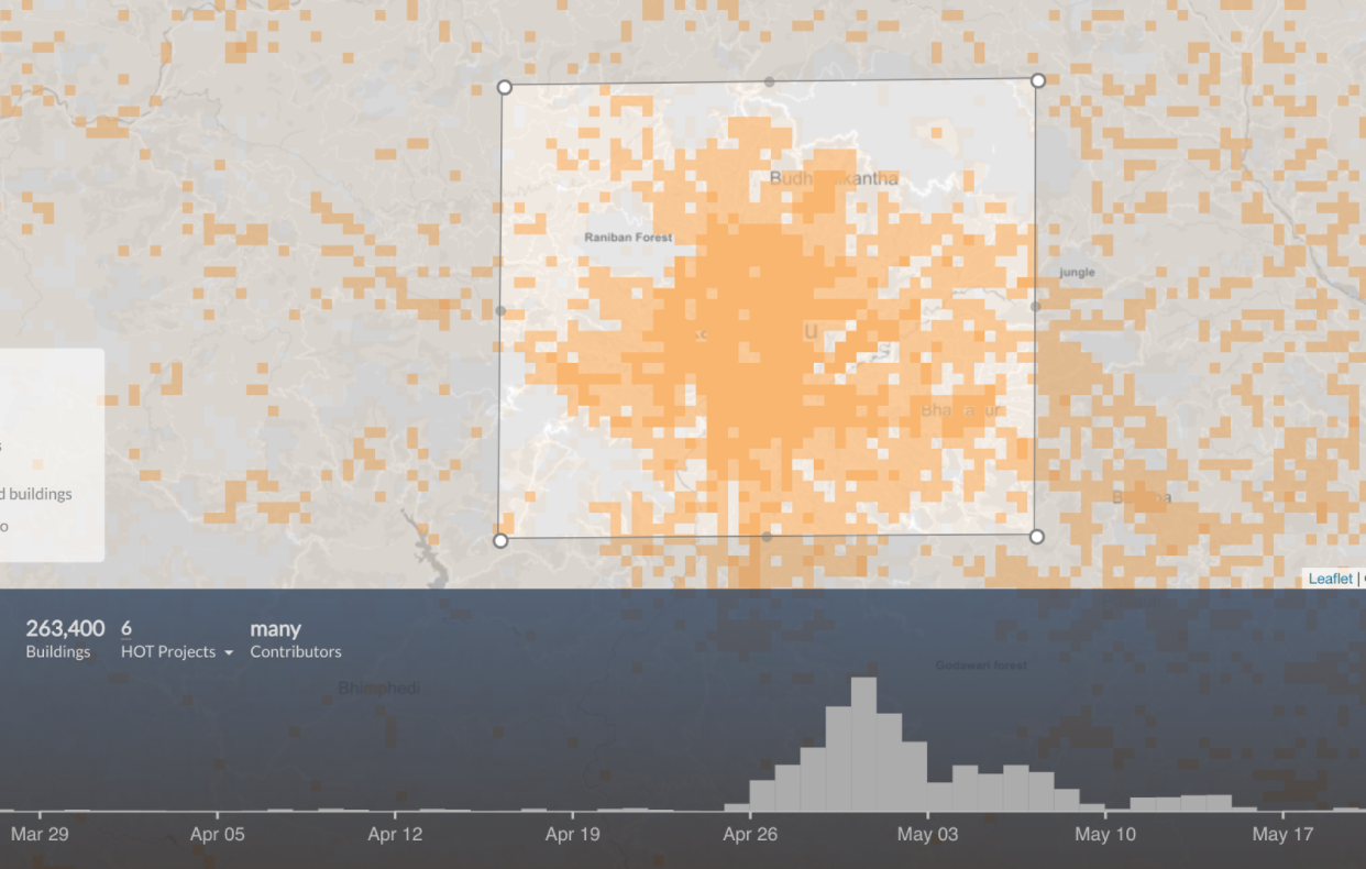
Figure 1: Time distribution of the building features created by OSM users for Kathmandu region.
UNOSAT's rapid mapping service, for example, typically requires a two-day turnaround post-image acquisition, assuming optimal conditions. The incorporation of deep learning approaches, specifically Convolutional Neural Networks (CNNs), offers a promising solution to enhance the efficiency of these processes.
Proposed Workflow for Rapid Assessment
The paper proposes a novel workflow that leverages deep learning to expedite damage assessments. The workflow comprises six main steps:
- Determine the Case of Interest: Focus on specific types of damage, such as "burned houses."
- Create a Training Dataset: Compile pre- and post-disaster imagery along with manually annotated labels of damaged structures.
- Train and Validate the Deep Learning Model: Utilize CNNs to learn and validate the detection of damage from training datasets.
- Obtain New Case Information: Gather new disaster data with similar characteristics to training data to ensure model applicability.
- Fine-Tune the Model: Adjust the model using new, specific disaster data to account for regional variations like light conditions.
- Run Automatic Image Processing: Deploy the fine-tuned model for automated and fast processing of the remaining data.
Experimentation and Results
The methodology was tested with wildfire incidents in Ventura and Santa Rosa counties, California. High-resolution satellite data was sourced from the DigitalGlobe Open Data Program to train the CNN model. Segmentation results showed promising accuracy, with pixel-wise F1-scores of 0.859 for burned and 0.818 for unburned buildings.
Fine-tuning the model for Santa Rosa, after initial unsatisfactory results without it, improved segmentation accuracy by quickly adjusting to local data characteristics. Training duration was significantly reduced, achieving efficient processing with high resource efficiency using technologies such as Keras with TensorFlow backend on a Tesla P100 GPU.
Implications and Future Work
The proposed framework demonstrates substantial improvements in damage assessment speed, facilitating better resource allocation in disaster-stricken areas. While initial setup requires ground truth creation, subsequent quick assessments can greatly enhance response times. Future research will focus on increasing segmentation accuracy and extending the methodology to other disaster types and regions. By advancing to instance segmentation, the method could eventually support precise object delineation in GIS applications.
Conclusion
This paper details a significant shift in emergency management practices by integrating deep learning into damage assessment workflows. By reducing the time required for critical response decisions, the methodology presents an efficient, scalable approach with potential applications beyond wildfires to include floods and other natural disasters. The combination of satellite imagery and AI technologies holds great promise for accelerating emergency response and recovery processes.

