DeepDamageNet: A two-step deep-learning model for multi-disaster building damage segmentation and classification using satellite imagery
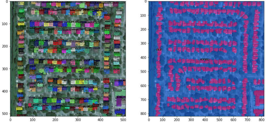
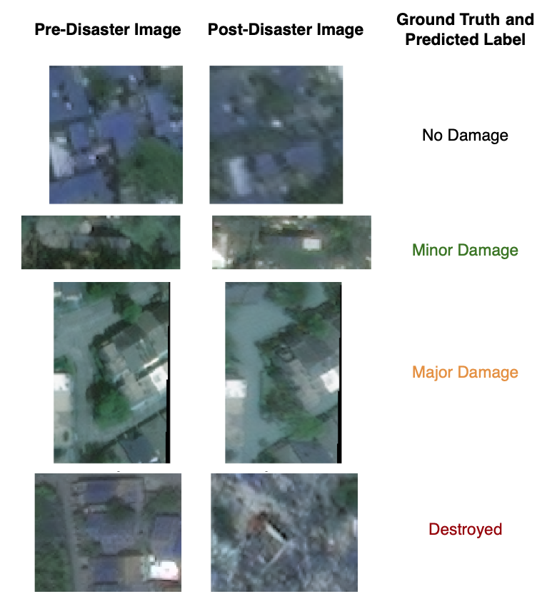
Abstract: Satellite imagery has played an increasingly important role in post-disaster building damage assessment. Unfortunately, current methods still rely on manual visual interpretation, which is often time-consuming and can cause very low accuracy. To address the limitations of manual interpretation, there has been a significant increase in efforts to automate the process. We present a solution that performs the two most important tasks in building damage assessment, segmentation and classification, through deep-learning models. We show our results submitted as part of the xView2 Challenge, a competition to design better models for identifying buildings and their damage level after exposure to multiple kinds of natural disasters. Our best model couples a building identification semantic segmentation convolutional neural network (CNN) to a building damage classification CNN, with a combined F1 score of 0.66, surpassing the xView2 challenge baseline F1 score of 0.28. We find that though our model was able to identify buildings with relatively high accuracy, building damage classification across various disaster types is a difficult task due to the visual similarity between different damage levels and different damage distribution between disaster types, highlighting the fact that it may be important to have a probabilistic prior estimate regarding disaster damage in order to obtain accurate predictions.
- Crowdsourcing earthquake damage assessment using remote sensing imagery. Annals of Geophysics, 54(6), 2012.
- Monitoring and evaluating post-disaster recovery using high-resolution satellite imagery—towards standardised indicators for post-disaster recovery. Martin Centre: Cambridge, UK, 2015.
- The role of remote sensing in earthquake science and engineering: Opportunities and challenges. Earthquake Spectra, 24(2):471–492, 2008.
- A comprehensive review of earthquake-induced building damage detection with remote sensing techniques. ISPRS Journal of Photogrammetry and Remote Sensing, 84:85–99, 2013.
- The capabilities of earth observation to contribute along the risk cycle. In Earthquake Hazard, Risk and Disasters, pages 25–53. Elsevier, 2014.
- Remote sensing-based proxies for urban disaster risk management and resilience: A review. Remote sensing, 10(11):1760, 2018.
- The Development and Uses of Crowdsourced Building Damage Information based on Remote-Sensing. Technical Report 1, 2018. URL https://purl.stanford.edu/bj915mt6570.
- Towards real-time building damage mapping with low-cost UAV solutions. Remote Sensing, 11(3):1–14, 2019. ISSN 20724292. doi:10.3390/rs11030287.
- Creating xbd: A dataset for assessing building damage from satellite imagery. In Proceedings of the IEEE Conference on Computer Vision and Pattern Recognition Workshops, pages 10–17, 2019.
- H Th Verstappen. Aerospace technology and natural disaster reduction. Advances in Space Research, 15(11):3–15, 1995.
- Satellite remote sensing of earthquake, volcano, flood, landslide and coastal inundation hazards. ISPRS Journal of Photogrammetry and Remote Sensing, 59(4):185–198, 2005.
- A segmentation and classification approach of ikonos-2 imagery for land cover mapping to assist flood risk and flood damage assessment. International Journal of applied earth observation and geoinformation, 4(3):217–229, 2003.
- U-net: Convolutional networks for biomedical image segmentation. In International Conference on Medical image computing and computer-assisted intervention, pages 234–241. Springer, 2015.
- Feature pyramid networks for object detection. In Proceedings of the IEEE conference on computer vision and pattern recognition, pages 2117–2125, 2017.
- Aerial imagery for roof segmentation: A large-scale dataset towards automatic mapping of buildings. arXiv preprint arXiv:1807.09532, 2018a.
- Masklab: Instance segmentation by refining object detection with semantic and direction features. In Proceedings of the IEEE Conference on Computer Vision and Pattern Recognition, pages 4013–4022, 2018b.
- Ternausnetv2: Fully convolutional network for instance segmentation. In CVPR Workshops, pages 233–237, 2018.
- Mask r-cnn. In Proceedings of the IEEE international conference on computer vision, pages 2961–2969, 2017.
- Sharada Prasanna Mohanty. Crowdai mapping challenge 2018 : Baseline with mask rcnn. https://github.com/crowdai/crowdai-mapping-challenge-mask-rcnn, 2018.
- Building damage detection in satellite imagery using convolutional neural networks. arXiv preprint arXiv:1910.06444, 2019.
- Multi3net: segmenting flooded buildings via fusion of multiresolution, multisensor, and multitemporal satellite imagery. In Proceedings of the AAAI Conference on Artificial Intelligence, volume 33, pages 702–709, 2019.
- Detectron2. https://github.com/facebookresearch/detectron2, 2019.
- Deep residual learning for image recognition. In Proceedings of the IEEE conference on computer vision and pattern recognition, pages 770–778, 2016.
- Faster r-cnn: Towards real-time object detection with region proposal networks. In Advances in neural information processing systems, pages 91–99, 2015.
- Imantics. Image semantics documentation. https://imantics.readthedocs.io/en/latest/#, 2019.
- Image quality assessment: from error visibility to structural similarity. IEEE transactions on image processing, 13(4):600–612, 2004.
Paper Prompts
Sign up for free to create and run prompts on this paper using GPT-5.
Top Community Prompts
Collections
Sign up for free to add this paper to one or more collections.

