- The paper presents a novel intermediary paradigm using centralized coarse-grained exclusive space allocation to enable parallel, collision-free UAV operations.
- It leverages a Dec-POMDP framework optimized with MAPPO, integrating a human fear penalty to balance collision avoidance with flight progression.
- Empirical results demonstrate improved convergence, reduced human psychological impact, and enhanced airspace utilization compared to traditional methods.
Dynamic Airspace Management for UAVs in Evolving Urban Environments: A Technical Analysis of Pharos
Introduction and Motivation
Effective airspace management for unmanned aerial vehicles (UAVs) in complex, densely populated urban environments is a central problem for future low-altitude urban mobility. Existing paradigms for managing UAV airspace—distributed local perception and centralized fine-grained control—entail trade-offs between safety, scalability, global awareness, and implementation cost. The distributed local perception paradigm can cause blind spots and collisions, while centralized approaches impose severe connectivity and standardization constraints.
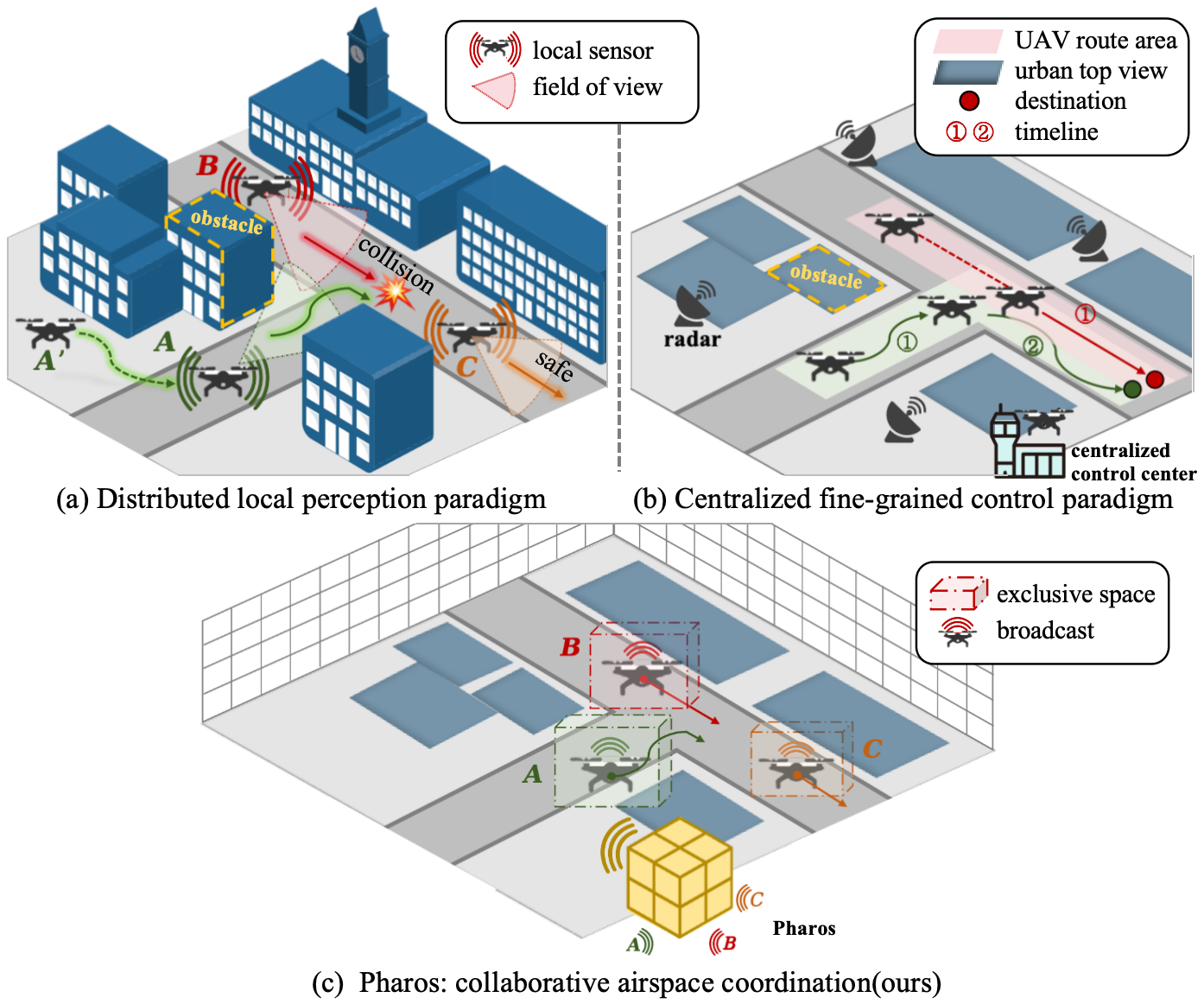
Figure 1: Three airspace management paradigms: (a) collision-prone local perception, (b) centralized safety with high communication/control cost, (c) Pharos’s exclusive-space coordination enabling parallel safe operation.
Pharos proposes a novel intermediary paradigm: centrally coordinated, coarse-grained allocation of non-overlapping exclusive spaces for each UAV, allowing for parallel, collision-free operation while minimizing both infrastructure requirements and restrictions on autonomous UAV control.
System and Modeling Approach
Pharos leverages a discrete 3D spatial model over a real urban environment, incorporating static structures (buildings), dynamic agents (UAVs), and moving humans.
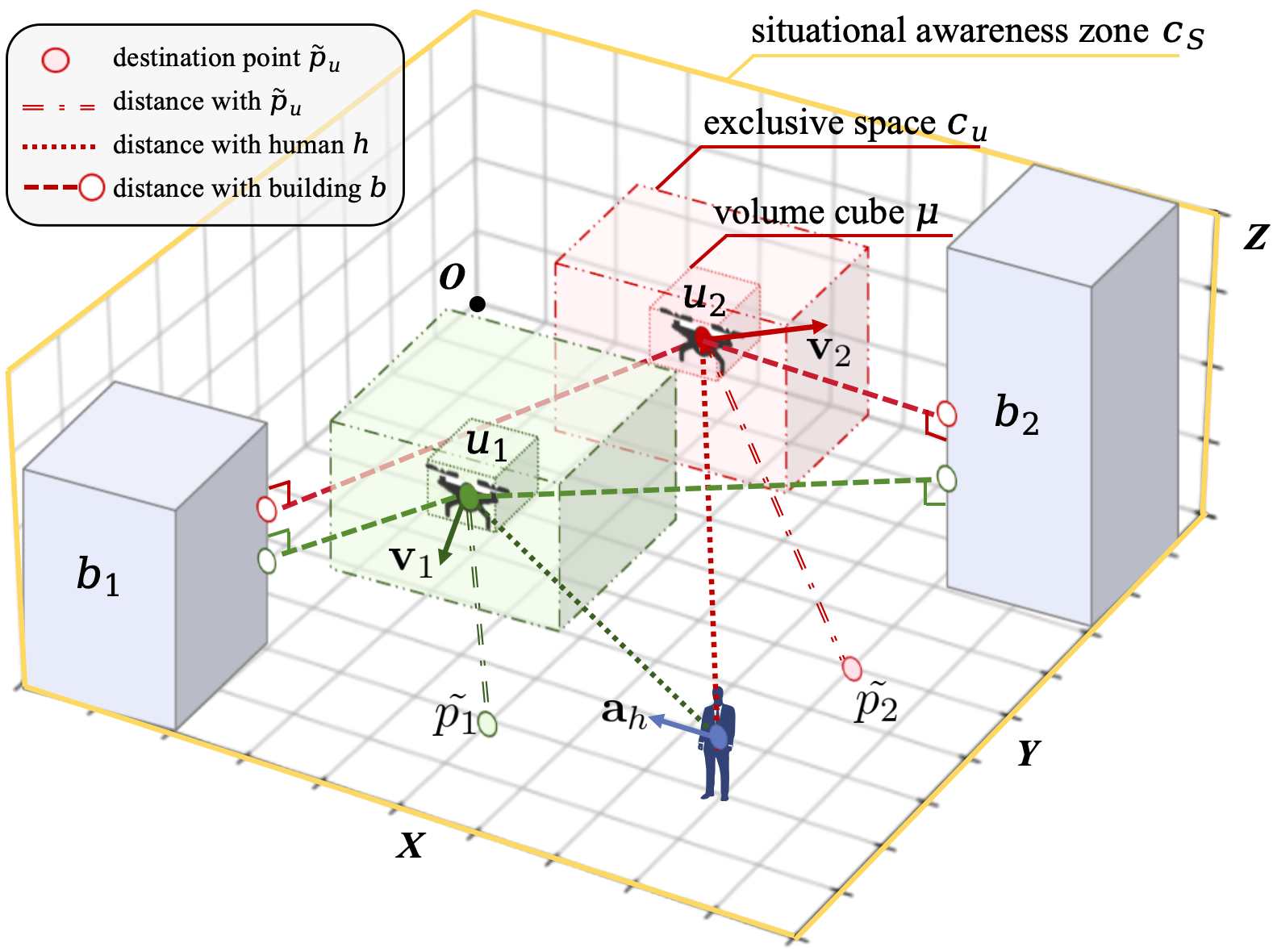
Figure 2: Multi-UAV management in a complex urban space, modeling buildings, UAV-exclusive space, and moving humans in a discretized cuboid grid.
At each timestep, each UAV is assigned a cuboid exclusive space, ensuring non-overlap with other UAVs, buildings, and humans. The core optimization objective is a weighted sum of: (1) collision penalties (for UAVs, humans, obstacles), (2) a novel quantification of human psychological fear induced by close UAV operations, and (3) incentives for flight progress towards destination.
A critical innovation is the explicit incorporation of a human fear penalty. This penalty is a function of UAV-human distance and the relative direction and speed:
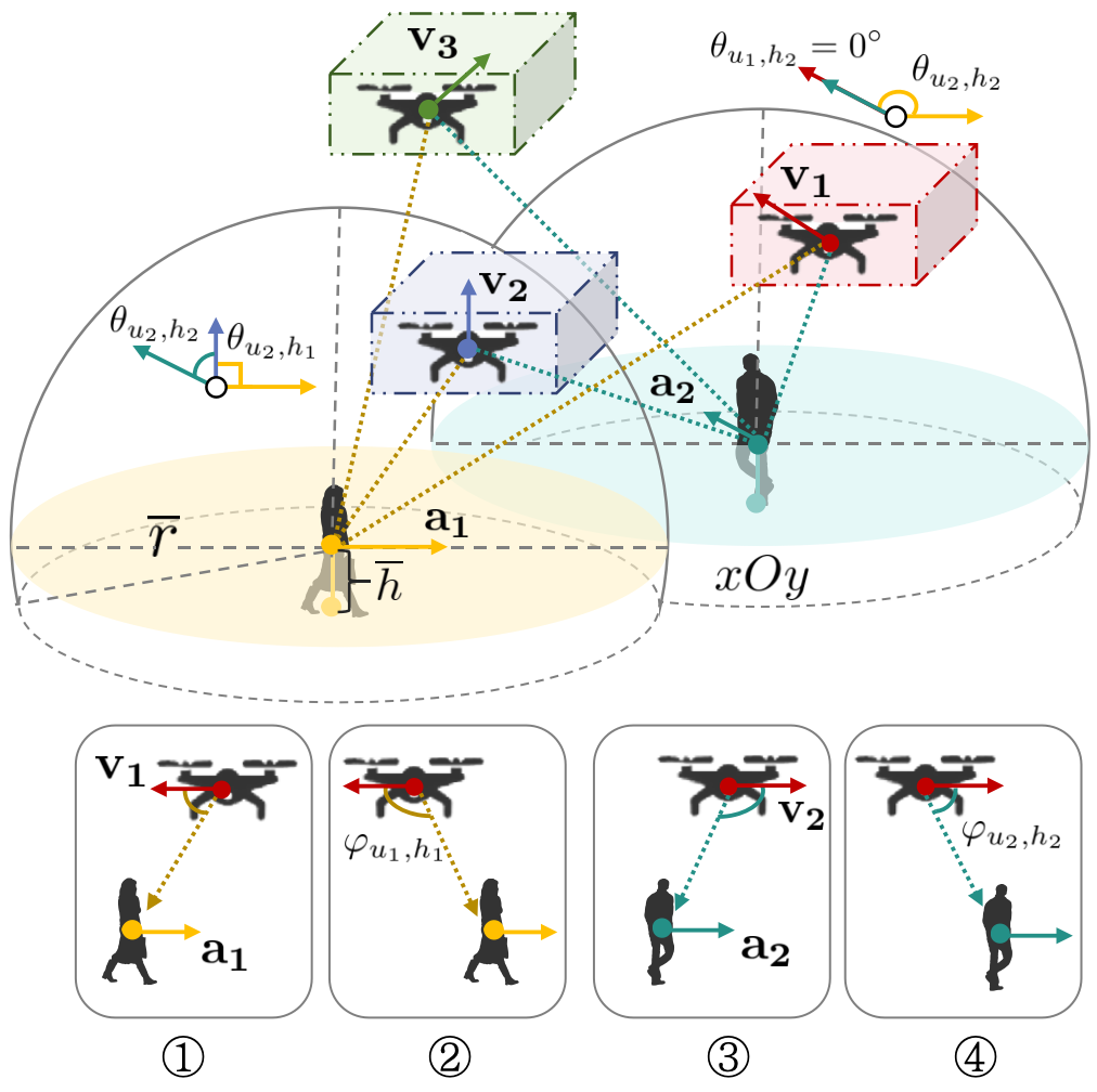
Figure 3: Human fear model, highlighting four UAV-human interaction geometries projected onto xOz.
The reward function is then maximized across all UAVs, subject to spatial and temporal constraints, to coordinate safe, efficient, and socially compatible trajectories.
Algorithmic Framework
Pharos is architected as a decentralized partially observable Markov decision process (Dec-POMDP), optimized with Multi-Agent Proximal Policy Optimization (MAPPO). Centralized training with global situational awareness is used to optimize policies; during inference, each agent operates in parallel based on local observations.
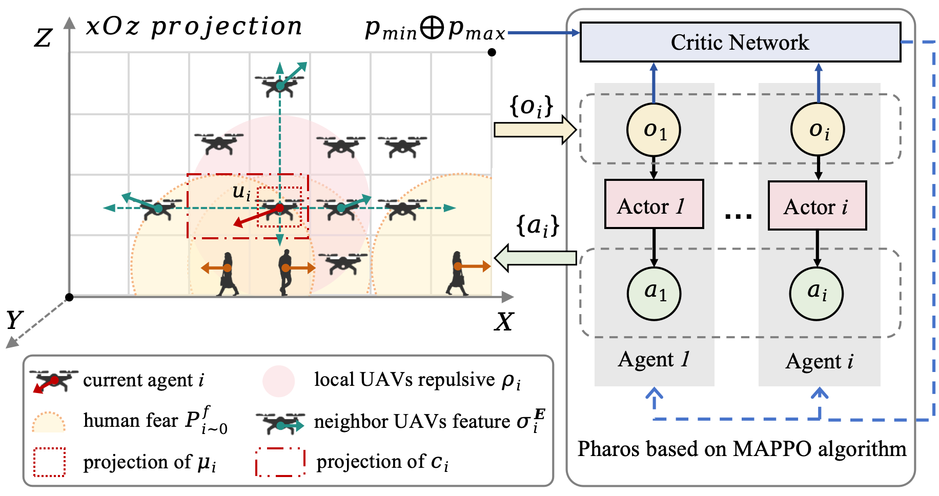
Figure 4: Pharos core algorithm using the MAPPO architecture for decentralized, parallel, exclusive space assignment.
Dense feature vectors are constructed for each UAV, encoding both local and limited non-local context: self-state, neighbor UAV repulsive force, neighbor UAV relative velocity, and human fear prediction across candidate directions. Actions correspond to space selection in seven directions (six axes + hover). Each exclusive space per agent is computed geometrically.
Simulation Environment
A realistic 3D urban testbed is constructed from OpenStreetMap-based data for a downtown Shanghai intersection, discretized at meter-scale granularity. The environment simulates moving humans and imposes no explicit route constraints beyond next-step reachability.
The system is benchmarked against:
- Ipopt: a mathematical programming optimizer providing continuous-space optimality for each timestep, but with no temporal credit assignment.
- A-star: classical discrete path-planning baseline.
- HAPPO/HATRPO: state-of-the-art multi-agent RL baselines.
A comprehensive hyperparameter selection is enforced, giving strongest penalization to collisions, followed by human fear, with flight progression as subordinate.
Evaluation and Empirical Results
Pharos’s effectiveness is demonstrated across coordination, collision avoidance, human-friendliness, and space efficiency metrics.
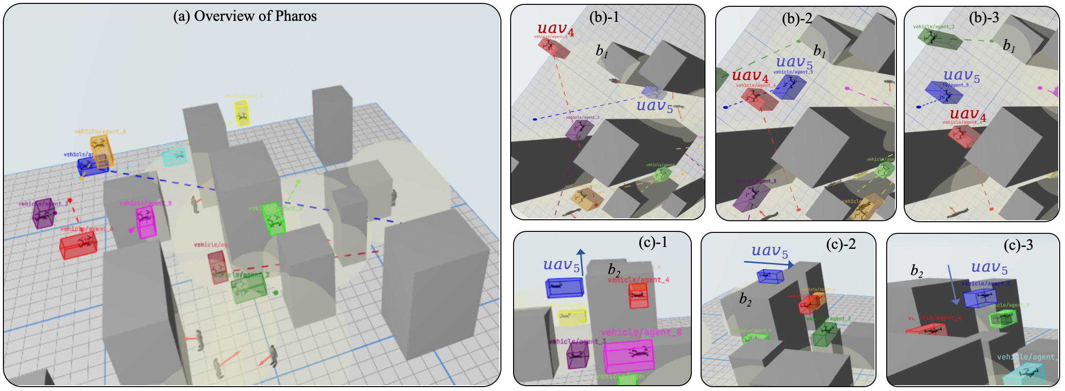
Figure 5: (a) Pharos visualization system overview; (b,c) snapshots of test cases highlighting system capabilities: intersection coordination and obstacle-adaptive detour.
Convergence and Policy Quality
Across several urban complexity settings, MAPPO-based Pharos demonstrates superior convergence speed and final reward relative to HAPPO/HATRPO.
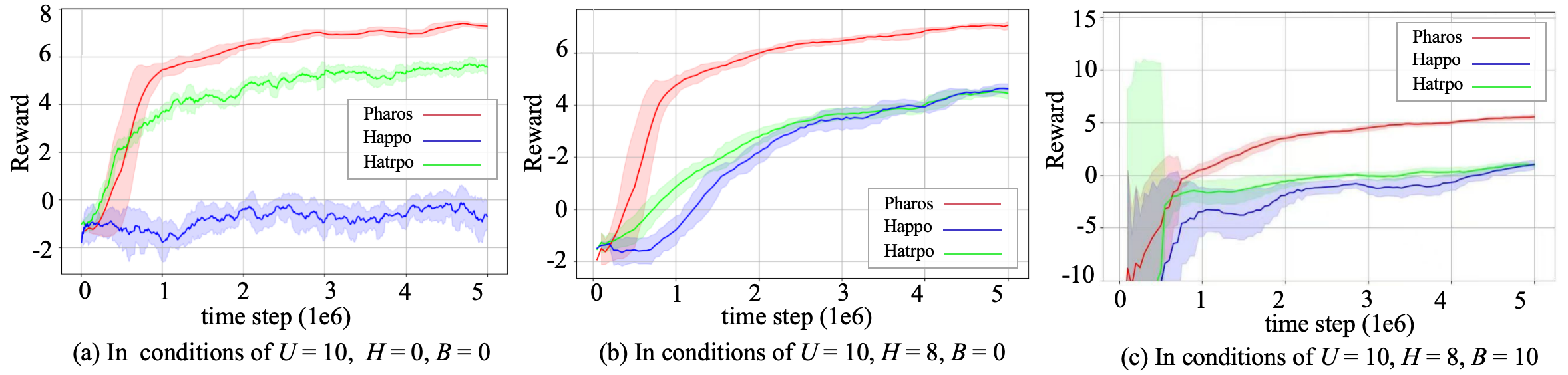
Figure 6: Training convergence comparison for MAPPO (Pharos) vs. HAPPO/HATRPO under various agent/building/human densities.
During online inference, Pharos with pre-trained policies consistently achieves higher cumulative reward than Ipopt (averaging 60.59% improvement), which is bound by single-step optimization and prone to myopic, hover-prone behaviors.
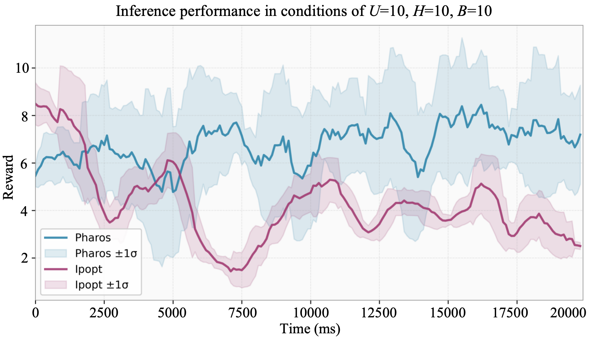
Figure 7: Inference comparison of Pharos versus Ipopt solver across 200 steps; Pharos maintains superior rolling reward.
Pharos is able to coordinate mutual avoidance at complex intersections and through densely built environments, as visualized in test-case rollouts. Flight progression incentives mitigate “deadlock” hovering.
Human fear penalty is quantitatively compared. Pharos achieves a mean reduction of 52.72% in average human fear value relative to the A-star path planner over 200 steps, under strict spatial exclusion. While Ipopt achieves the lowest fear, it does so by sacrificing mobility (agents hover indefinitely under uncertainty), an undesirable operational property.
Airspace Utilization
Pharos outperforms both Ipopt and A-star in spatial entropy—a proxy for uniform airspace utilization. Compared to Ipopt, Pharos yields a 70.82% increase, and compared to A-star, a 2.03% increase in entropy, highlighting its ability to promote both fairness and efficiency in resource distribution under operational constraints.
Scalability
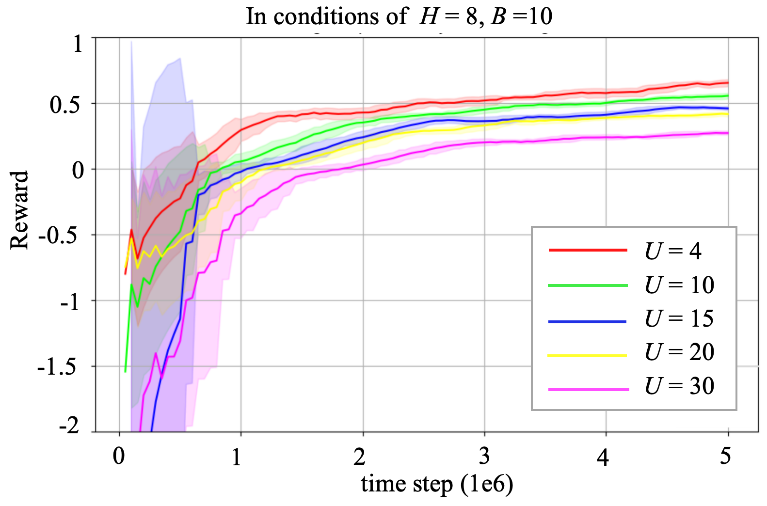
Figure 8: Scalability: training convergence of per-agent average reward as number of agents/scenario scale increases (MAPPO Pharos).
Pharos demonstrates linear scaling of computational cost in number of agents, with parallelizable inference and practical end-to-end latency (∼100 ms per step), suiting real-time urban scenarios with large UAV populations.
Implications and Future Directions
Pharos represents a substantive systems- and algorithm-level advancement for practical UAV airspace management in urban settings. By decoupling detailed trajectory planning from coarse-grained, exclusive space assignment and directly quantifying human psychological response, Pharos achieves high-throughput, scalable, socially-aware coordination.
Key implications:
- Regulatory adoption: Centralized coarse-grained control can serve as an enforceable ablation for urban airspace regulation, with strong guarantees on collision and human impact.
- Integration extensibility: The architecture naturally supports heterogeneous UAV fleets (no access to proprietary control surfaces needed) and can be extended to 4D spatio-temporal allocations.
- Policy shaping: The human fear quantification may inform more nuanced social-technical contracts for urban mobility.
Future research will focus on cross-zone (multi-cell) coordination to scale to city-wide deployments, dynamic entropy-driven UAV admission and allocation, and 4D data management frameworks to incorporate time-evolving human and obstacle maps.
Conclusion
Pharos, as introduced in "Dynamic Airspace Management for UAVs in Evolving Urban Environments: Collaborative Coordination and Human Safety" (2607.04825), delivers a centrally coordinated, MARL-driven airspace management solution for multi-UAV operation in dynamic, urban contexts. It demonstrates robust convergence, significantly reduced human psychological impact, and superior airspace utilization versus classical mathematical optimization and path-planning approaches. The work provides a technically rigorous and extensible foundation for safe, scalable, and socially compatible UAV integration into cities.