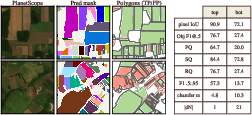
- The paper shows that deploying 3m PlanetScope imagery significantly enhances field-boundary segmentation, achieving nearly 70% higher panoptic quality than 10m Sentinel-2.
- It utilizes an object-centric evaluation with metrics such as polygon-level F1, panoptic quality, and boundary error to rigorously quantify segmentation improvements.
- The study provides actionable insights for agricultural monitoring by outlining how high-resolution data can accurately delineate smallholder plots and inform hybrid mapping strategies.
Fields of the Planet: Advancing Field Boundary Mapping with 3m Imagery
Introduction
Field-boundary segmentation underpins critical downstream tasks in agricultural monitoring, such as crop yield prediction, irrigation analysis, and global food security assessments. However, the global majority of farms—smallholder plots under 2 ha—pose a fundamental challenge for conventional remote sensing techniques, as their boundaries are typically unresolved in 10 m satellite imagery such as Sentinel-2. The "Fields of the Planet" (FTP) dataset (2607.04449) introduces a paradigm shift, pairing the extensive, multi-country Fields of The World (FTW) annotation protocol with 3 m PlanetScope imagery to systematically quantify the gains of higher spatial resolution for parcel delineation. This work evaluates the implications through rigorous, controlled benchmarking, advocates for object-centric evaluation protocols, and releases community resources to enable reproducible research.
Dataset Construction and Scope
FTP aligns with FTW's 1.6 million multi-continent field-boundary polygons, preserving identical patch/windows and train/validation/test splits. The critical innovation is the pairing of these polygons with co-registered 3 m PlanetScope scenes, yielding 133,168 patch-window targets in 24 countries. FTP implements robust patch-level quality control using Planet’s UDM2 masks, ensures seasonal alignment, and excludes low-quality acquisitions—resulting in coverage rates up to 99% in optimal regions, though some areas (notably Portugal, Finland, Netherlands) exhibit reduced retention due to cloud prevalence.
By keeping the label rasterization protocol consistent, FTP provides a uniquely controlled experimental design—isolating the effects of increased spatial resolution rather than dataset/label variations.
Resolution Limitations of 10 m Imagery
Critically, the paper documents the hard limit imposed by 10 m imagery on the recoverability of small fields, independent of model architecture or learning. Only approximately 7.5% of sub-0.5 ha parcels can be resolved to a distinct polygon after rasterizing to a 10 m grid, compared with 88% at 3 m. This result demonstrates that significant signal loss occurs before any downstream modeling.
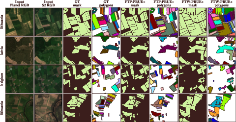
Figure 1: PlanetScope, at 3 m resolution, resolves dense clusters of sub-0.5 ha parcels that are merged beyond recognition in Sentinel-2 10 m imagery.
Benchmarking Protocols and Model Evaluation
FTP employs a polygonal vector-matching evaluation, focusing on object F1, panoptic quality (PQ), and meter-scale boundary error—measures directly relevant for geospatial pipelines, in contrast to largely protocol-driven pixel IoU metrics. The baseline models are U-Nets with EfficientNet backbones, subjected to strictly matched training and inference regimes across imagery sources. Augmentation strategies—especially geometric and noise variants—proved particularly impactful for modeling on 3 m imagery.
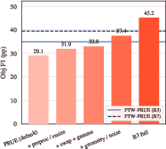
Figure 2: Successive introduction of PRUE+ augmentations delivers substantial polygon-level gains, positioning PlanetScope-based models ahead of all Sentinel-2 baselines.
Main Numerical Findings
The introduction of 3 m PlanetScope imagery drives strong, consistent improvements in every object-centric metric relative to 10 m Sentinel-2:
These results are robust across 22 of 23 evaluated regions, including diverse agro-ecological zones, and highlight the necessity of polygon-level, rather than pixel-based, reporting.
Upsampling and Output Grid Experiments
To disentangle the effects of a finer output grid from true sensing improvements, experiments with upsampled Sentinel-2 imagery reveal only partial recovery of object-level metrics, with boundary localization lagging far behind real 3 m input. This finding underscores that only actual high-resolution source data, not synthetic upscaling or post-hoc grid refinements, permit correct separation of adjacent fields and accurate geometry restoration.
Region- and Field-Scale Analysis
Across the macro-averaged global benchmark, PlanetScope delivers PQ gains of up to 14 points over the best Sentinel-2 models. Importantly, the impact is most pronounced for sub-0.5 ha parcels—high-resolution imagery does not merely smooth boundaries but enables distinction where Sentinel-2 merges or omits objects entirely. The only region with parity is Portugal, where field boundaries are primarily cadastral and do not correspond to image edges.
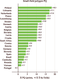
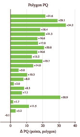
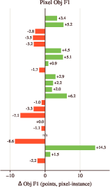
Figure 4: Across 23 regions, PlanetScope universally outperforms or matches Sentinel-2 in polygon PQ, most strongly in small-field strata.
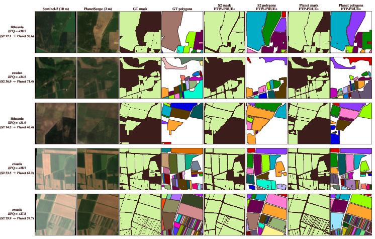
Figure 5: In high-gain patches, PlanetScope models restore parcel separation and shape, resolving dense mosaics of smallholder plots far beyond Sentinel-2’s capabilities.
Implications and Future Directions
The adoption of 3 m PlanetScope imagery fundamentally expands the solution space for field-boundary segmentation, transforming previously unresolvable micro-parcel mosaics into actionable geospatial units. For practitioners, these findings argue for direct deployment of high-resolution commercial data in food security, rural economics, and agricultural monitoring pipelines, particularly in smallholder-dominated landscapes.
Theoretically, the results reinforce the importance of metric choice in assessing segmentation systems—polygon- and boundary-based criteria are essential when the application demands instance geometry, not mere semantic coverage.
The dataset’s structure imprints a path forward for multi-sensor, resolution-aware modeling: hybrid systems could exploit 3 m data where it exists and default to 10 m public data elsewhere, propagating improvements globally as commercial coverage expands. Moreover, with community tools and pipeline code released, the field is positioned to tackle additional open challenges: (i) country-scale deployment, (ii) multi-year and multi-band analysis, (iii) joint cross-sensor training, and (iv) improved label completeness in new regions.
Conclusion
"Fields of the Planet" (2607.04449) establishes that spatial resolution is a primary determinant of recoverable geometrical information in agricultural field-boundary segmentation. The controlled transition from 10 m to 3 m input results in order-of-magnitude improvements in smallholder parcel recovery and boundary localization, confirmed across diverse countries and consistent within rigorous polygonal evaluation frameworks. The work decisively supports the paradigm of high-resolution, object-centric mapping for operational geospatial AI, setting a new technical baseline for public benchmarks and future methodological advances.