JL1-CC&QA: Extending the JL1-CD Benchmark with Change Captioning and Question Answering
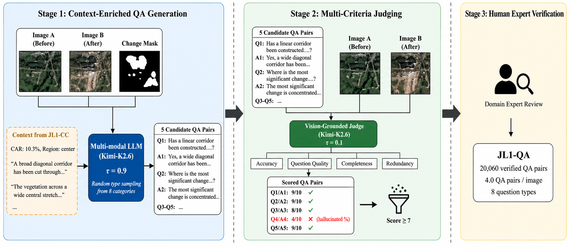
Abstract: Remote sensing change detection (CD) traditionally focuses on pixel-level binary segmentation, which identifies where changes occur but neither what nor why. To bridge this semantic gap, we introduce JL1-CC&QA, a multi-task benchmark that extends the JL1-CD dataset with two complementary annotation layers: change captioning (CC) and change question answering (QA). Built upon 5,000 bi-temporal image pairs acquired by the Jilin-1 satellite at 0.5-0.75m ground sample distance, the benchmark comprises: (i) JL1-CC, providing 17,021 quality-verified captions that describe diverse land-cover transformations; and (ii) JL1-QA, offering 20,060 question-answer pairs across eight question types, enabling fine-grained, interactive interrogation of surface changes. All annotations are produced via a three-stage pipeline consisting of multi-modal LLM generation, vision-grounded LLM judging, and human expert verification. We hope that JL1-CC&QA, as a benchmark unifying binary change masks, change captions, and change-oriented QA over the same image set, will serve as a valuable resource for the community to advance multi-task change understanding in remote sensing. The dataset is available at https://github.com/circleLZY/JL1-CD.
Paper Prompts
Sign up for free to create and run prompts on this paper using GPT-5.
Top Community Prompts
Explain it Like I'm 14
Overview: What this paper is about
Think of a “spot the difference” game, but with satellite photos of Earth. Most tools today can show you where something changed between two pictures (like new buildings or trees cut down), but they don’t tell you what changed or why. This paper introduces a new dataset, called JL1-CCQA, that adds simple sentences and questions-and-answers on top of those before-and-after satellite images. This helps computers not only find changes, but also describe them and answer questions about them in normal language.
Goals: What the researchers wanted to achieve
The paper aims to:
- Turn “just a change map” into “change with meaning,” by adding words to the pictures.
- Let AI describe changes in full sentences (change captioning).
- Let AI answer natural questions about those changes (question answering).
- Provide one single dataset where all three things live together: the change map, the caption, and the Q&A. This makes it easier to train and compare smarter models.
How they did it: The approach in simple terms
They started with a dataset called JL1-CD:
- It has 5,000 pairs of satellite images from the Jilin-1 satellite.
- Each pair is a “before” and an “after” image of the same place (resolution is about 0.5–0.75 meters, so you can see roads, buildings, fields, and more).
- It already includes a “change mask,” which is like coloring in all the pixels that changed.
They then added two new layers:
- Change Captioning (JL1-CC): writing short descriptions of what changed.
- Change Question Answering (JL1-QA): writing questions and answers about the changes (for example, “Did a new road appear?” → “Yes, along the right edge.”).
To build these layers, they used a three-step pipeline, similar to drafting an essay, editing it, and getting a final check:
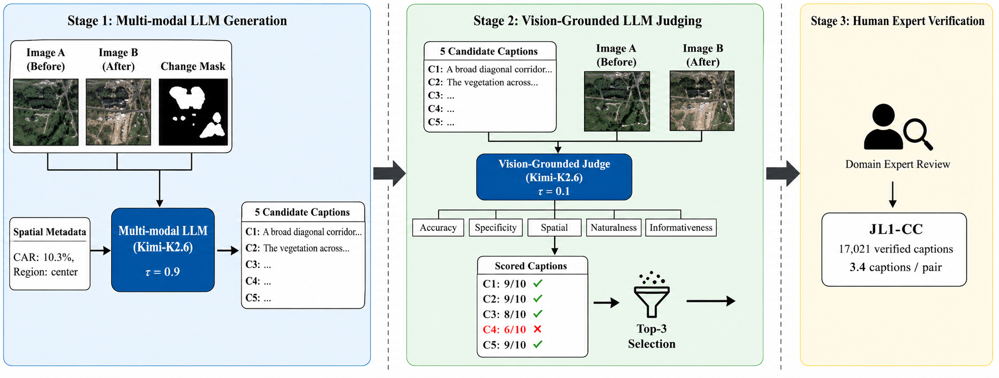
- Step 1: An AI that can see images and read text (a multimodal LLM) looks at the before image, after image, and the change mask, and writes multiple possible captions or Q&A pairs.
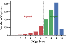
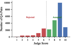
- Step 2: A second AI “judge” checks each caption or Q&A against the images for accuracy, clarity, and usefulness, and scores them. Only the best ones are kept.
- Step 3: Human experts review a sample to make sure things are correct and to catch common mistakes.
They also used helpful signals like the “change area ratio” (what percent of the picture changed) and a simple description of where the change is (like “upper-left”), to guide the AI.
Key terms explained:
- Change mask: a picture that highlights exactly where pixels changed—like shading all the spots that are different.
- Caption: a short sentence that describes what changed, where, and how much.
- Question answering: asking a normal question about the images and getting a clear, short answer.
- Multimodal AI: an AI that can understand both images and text at the same time.
Main results: What they built and why it matters
- JL1-CC (captions): 17,021 high-quality captions that describe many kinds of changes (buildings, roads, farms, forests, water, solar panels, and more).
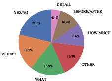
- JL1-QA (questions and answers): 20,060 Q&A pairs across eight helpful question types, such as:
- YES/NO: Did something new appear?
- WHAT: What changed in the center?
- WHERE: Where is the biggest change?
- HOW MUCH: Is the change large or small?
- BEFORE/AFTER: What was there before, and what is there now?
- CAUSE: What might have caused the change (e.g., construction)?
- DETAIL: What do the new structures look like?
- COMPARE: Which area changed the most?
Quality control:
- They created many candidates and kept only the best, using the AI judge and human checks.
- This reduces “hallucinations” (AI making stuff up) and improves accuracy.
Why this is important:
- Instead of only saying “something changed here,” the dataset helps AI say “a new road was built along the right side,” or answer “Yes, new buildings appeared near the top.” That’s much closer to how people talk and make decisions.
Impact: What this means for the future
With JL1-CCQA, researchers can train AI systems that:
- Detect where things changed.
- Explain what changed in simple language.
- Interact with users through questions and answers.
This can help with:
- Urban planning: spotting and describing new buildings or roads.
- Environment monitoring: explaining forest loss or new water areas.
- Disaster response: quickly answering where damage happened and what kind it is.
- Education and transparency: making satellite analysis understandable to non-experts.
In short, the dataset moves change detection from “just a map of differences” to “clear, human-friendly explanations,” making satellite data more useful for real-world decisions. The data and code are publicly available, so others can build on it and push the field forward.
Knowledge Gaps
Knowledge gaps, limitations, and open questions
Below is a concise, actionable list of what remains unclear or unaddressed in the paper, aimed at guiding future research.
- Absence of baseline results and benchmarks: No empirical evaluations are provided for CC or QA on JL1-CCQA (e.g., training/evaluating captioning, VQA, or multi-task models), leaving model performance and task difficulty unknown.
- Undefined evaluation protocols: The paper does not specify official metrics or scripts for CC (e.g., BLEU, CIDEr, SPICE) or QA (e.g., exact match, semantic similarity, LLM-based grading), nor answer normalization, synonym handling, or acceptance criteria.
- Limited human validation and no reliability reporting: Only a subset of annotations is human-verified; inter-annotator agreement, human–LLM agreement, and residual error rates of accepted items are not quantified.
- Reliance on LLM-as-a-judge remains unvalidated: The accuracy and bias of the LLM judge versus human experts are not systematically assessed; correlations and failure modes are unreported.
- Reproducibility risks in annotation pipeline: Exact prompts, temperature/seed settings, and judge/generator model versions (Kimi-K2.6, etc.) are not fully specified within the paper; the impact of swapping to open-source LLMs or different versions is unstudied.
- Dataset scope is geographically and sensor limited: All imagery is JL-1 optical RGB from provinces in China; generalization to other regions, sensors (e.g., WorldView, Sentinel-2), and modalities (MS, HS, SAR, cross-modal) is untested.
- Bi-temporal only and curated conditions: Images exclude clouds/extreme illumination; robustness under operational conditions (clouds, seasonal/illumination shifts) and extension to multi-temporal sequences remain open.
- Binary masks without semantic or instance grounding: Despite rich language, masks are binary; there is no per-class segmentation, instance-level change delineation, or phrase-to-region grounding to spatially anchor textual descriptions.
- Spatial-language evaluation is undefined: There is no metric to assess whether location references in captions/answers (e.g., “upper-left”) align with change masks or actual regions.
- QA causal reasoning is weakly grounded: “CAUSE” questions/answers may rely on unverifiable commonsense; how to validate causal claims (without external data) and ensure factuality is unaddressed.
- Context leakage between captions and QA: QA generation uses selected captions from the same image as context, potentially making QA artificially easier and inflating downstream performance; no protocol to separate caption-conditioned and caption-agnostic QA is proposed.
- No multilingual support: All annotations appear in English; the absence of multilingual captions/QA limits accessibility and cross-lingual research.
- Missing geospatial and temporal metadata: No georeferencing or acquisition timestamps are provided for modeling seasonality, temporal intervals, or integration with GIS/exogenous data.
- Limited coverage of rare/critical changes: The distribution of change categories (e.g., disasters, floods, landslides, demolition) is not quantified; coverage of rare but important events may be sparse.
- Coarse magnitude supervision only: The pipeline forbids precise numeric answers (e.g., areas, counts), limiting research on numeric reasoning and quantitative change estimation.
- No multi-turn dialogues: Only single-turn QA is provided; building and evaluating conversational agents for change analysis (context carryover, follow-up questions) remains unexplored.
- Split consistency and mapping across tasks: Although train/test counts are given, consistent image-level alignment across CD/CC/QA splits (and the noted 4,999 vs. 5,000 image pairs in JL1-QA) is not clarified; a standardized split mapping is needed.
- Potential annotation bias from provided spatial hints: Generators receive mask + CAR + region descriptors (e.g., “upper-left”); ablation on these inputs’ influence and potential biases is unreported.
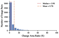
- Long-tail handling untested: The dataset has a long-tailed change area ratio (CAR), but no analyses show how CC/QA quality varies with CAR or how models should be evaluated/stratified by scale.
- No cross-dataset transfer studies: It is unclear how models trained on JL1-CCQA transfer to other CC/CDVQA datasets (and vice versa), or how well they generalize across sensors and geographies.
- Lack of task synergy experiments: Whether joint training on masks, captions, and QA improves any task (e.g., CD performance via language supervision) is not demonstrated.
- Annotation scalability and cost unknowns: Throughput, cost, and time of the three-stage pipeline (LLM-gen, LLM-judge, human check) are not reported; feasibility for scaling to 50k–100k+ pairs is unclear.
- Incomplete error taxonomy: While common rejection reasons are listed, a systematic analysis of accepted-error types (e.g., subtle hallucinations, over-generalizations, spatial misreferences) is missing.
- No fairness/bias analysis: Potential geographic, land-cover, or cultural biases introduced by JL-1 imagery or LLM-generated language are not examined, nor are mitigation strategies proposed.
- Licensing/usage details unspecified in text: Dataset and code are linked but licensing terms, permissible uses, and redistribution constraints are not described in the paper.
- Missing practitioner validation: No user studies assess whether the captions and QA genuinely aid human analysts in real-world decision-making (e.g., disaster response, urban monitoring).
Practical Applications
Summary
The paper introduces JL1-CCQA, a high-resolution (0.5–0.75 m) remote sensing benchmark built on 5,000 Jilin-1 bi-temporal image pairs that unifies binary change masks with 17,021 change captions and 20,060 change-oriented QA pairs across eight question types. It also contributes a scalable three-stage annotation pipeline (multi-modal LLM generation, LLM judging, human verification). These assets enable language-grounded change understanding and interactive querying, supporting multi-task training and evaluation across change detection (CD), change captioning (CC), and change QA (VQA-like).
Below are practical applications derived from the dataset and pipeline, grouped by deployment horizon.
Immediate Applications
The following use cases can be prototyped or deployed now with existing imagery, models, and the released dataset/code.
- Rapid disaster change briefings and triage
- Sectors: emergency management, insurance, humanitarian response
- What: Use fine-tuned CC/QA models to auto-generate plain-language summaries of flood, earthquake, or storm impacts (e.g., “roads washed out in lower-right; buildings added/removed”) and answer targeted questions (“Are bridges intact in the center?”).
- Tools/workflows: “Change-to-brief” dashboards; incident chat assistants for pre-/post-event imagery; claim triage with instant change narratives.
- Assumptions/dependencies: Timely, cloud-free imagery; optical limitations in cloudy events; model generalization beyond China; operational thresholds for false positives.
- Infrastructure and construction monitoring with narrative reports
- Sectors: AEC, urban planning, civil engineering, regulators
- What: Routine monitoring of designated areas to describe where new roads/buildings/hardscapes appear and respond to questions about progress or encroachment.
- Tools/workflows: Geofenced watchlists that trigger captioned alerts; periodic compliance summaries; interactive QA for inspectors.
- Assumptions/dependencies: Sufficient revisit rate; geo-aligned image pairs; policy-required accuracy and auditability.
- Energy asset mapping and expansion tracking (e.g., PV growth)
- Sectors: energy, utilities, ESG analytics
- What: Detect and describe photovoltaic expansions and related land-cover shifts; answer “where/how much/what” questions.
- Tools/workflows: PV intelligence feeds; ESG dashboards linking masks to narratives and Q&A; portfolio monitoring.
- Assumptions/dependencies: RGB resolution sufficient for PV appearance in target regions; spectral ambiguity; generalization to different panel types and geographies.
- Agricultural land-use and seasonal change interpretation
- Sectors: agri-tech, land management, rural planning
- What: Summarize cropland to non-cropland conversions, greenhouse expansions, water body changes; QA supports field-specific queries.
- Tools/workflows: Field-level change interpreters; advisories explaining “what/where” without requiring expert image reading.
- Assumptions/dependencies: Distinguishing phenology vs structural change; need local calibration; image timing and revisit cadence.
- Environmental monitoring bulletins (deforestation, wetland/water dynamics)
- Sectors: conservation NGOs, environmental regulators
- What: Automated plain-language bulletins with spatial references and Q&A for protected areas.
- Tools/workflows: Watchlists with captioned alerts; interactive portals for rangers and analysts.
- Assumptions/dependencies: Optical-only limits under cloud cover; need to validate against ground truth; generalizability beyond training distribution.
- Analyst productivity and QA for geospatial firms
- Sectors: geospatial services, software vendors
- What: Use JL1-CCQA to pretrain/evaluate multi-task models; adopt the LLM judge to score and filter auto-generated annotations; reduce manual load.
- Tools/workflows: Annotation pipelines with LLM-based quality gates; internal benchmarks for CD+CC+QA performance tracking.
- Assumptions/dependencies: Access to MLLMs; compute and cost control; data governance/compliance.
- Conversational GIS/EO assistants for exploration and education
- Sectors: software, education
- What: Build chat-style interfaces over bi-temporal imagery to answer change questions and teach remote sensing concepts.
- Tools/workflows: Notebooks and web apps leveraging JL1-QA question types; course materials with interactive exercises.
- Assumptions/dependencies: Appropriate licensing; lightweight inference or API access; user training to avoid overtrusting model outputs.
- Vendor/model evaluation and procurement support
- Sectors: public agencies, enterprise buyers
- What: Use the unified benchmark to compare vendors’ CD/CC/QA capabilities with consistent metrics and qualitative outputs.
- Tools/workflows: Bake-off evaluations tied to JL1-CCQA tasks; scoring rubrics incorporating QA correctness and caption quality.
- Assumptions/dependencies: Representativeness of JL1 imagery and China-focused content; alignment to operational sensor stacks.
Long-Term Applications
These require further research, broader data coverage (e.g., SAR, global diversity), scaling, or integration into operational systems.
- Global, language-grounded change agents with multi-turn reasoning
- Sectors: cross-sector (public safety, environment, infrastructure, finance)
- What: Agents that track evolving sites, answer multi-turn queries, and compose narratives (what/where/how/why) across time series.
- Tools/workflows: EO copilots integrated with tasking, data catalogs, and knowledge bases; event-driven reports.
- Assumptions/dependencies: Multi-modal fusion (optical+SAR), robust temporal modeling, reliability safeguards, provenance tracking.
- Regulatory compliance and enforcement at scale (explainable)
- Sectors: land-use regulation, forestry, mining, coastal management
- What: Automated detection of unpermitted activities with human-readable justifications and spatial evidence.
- Tools/workflows: Compliance monitoring platforms producing action-ready narratives and QA logs; audit trails for legal defensibility.
- Assumptions/dependencies: High precision/recall; legally accepted validation protocols; standardized outputs and uncertainty quantification.
- Digital twins enriched with change narratives
- Sectors: smart cities, transportation, utilities
- What: Feed captioned changes and QA responses into city-scale digital twins to maintain up-to-date assets and scenarios.
- Tools/workflows: Streaming integration to 3D/temporal twins; automated “change tickets” with natural-language context.
- Assumptions/dependencies: Continuous data pipelines; robust georegistration; governance and versioning.
- Autonomous inspection with natural-language reporting
- Sectors: robotics, AEC, critical infrastructure
- What: Drones/UGVs perform periodic surveys and produce human-friendly change explanations for operators.
- Tools/workflows: Edge-deployable VLMs; mission planning integrating change QA tasks.
- Assumptions/dependencies: Edge compute constraints; synchronization between aerial and satellite views; safety and privacy.
- Foundation models for Earth observation with language-grounded change pretraining
- Sectors: AI research, EO platforms
- What: Use JL1-CCQA as a seed for pretraining VLMs specialized in change, then scale with diverse global data for zero-/few-shot performance.
- Tools/workflows: Open-weight EO VLMs; adapters for enterprise deployment.
- Assumptions/dependencies: Larger, diverse corpora (sensors, geographies, seasons); compute resources; licensing for broad redistribution.
- Automated, scalable annotation services for EO datasets
- Sectors: data providers, map platforms
- What: Generalize the three-stage pipeline (generate → judge → verify) to produce captions/QA for new sensors and regions.
- Tools/workflows: Annotation-as-a-service; configurable taxonomies and quality thresholds; active learning loops.
- Assumptions/dependencies: MLLM availability/cost; domain adaptation; human-in-the-loop capacity.
- ESG and sustainability reporting with explainable geospatial evidence
- Sectors: finance, corporate sustainability
- What: Provide narrative-backed evidence of land-use change, deforestation risk, or renewable build-out for disclosures.
- Tools/workflows: Portfolio monitoring with linked masks, captions, and Q&A audit trails.
- Assumptions/dependencies: Accepted reporting standards; spatial attribution to assets; rigorous accuracy and bias assessment.
- Consumer-facing, real-time change alerts with summaries
- Sectors: navigation, real estate, local governance
- What: Public-facing alerts describing new roads, construction, or water changes, with Q&A for residents and planners.
- Tools/workflows: APIs serving “what/where” narratives; municipal portals; citizen science apps.
- Assumptions/dependencies: Data rights and privacy; latency and revisit rates; content moderation and reliability.
Cross-Cutting Assumptions and Dependencies
- Data domain and sensor limits: Current data are optical RGB from China (2022–2023) at 0.5–0.75 m GSD; generalization to other regions/sensors (e.g., SAR, multispectral) requires adaptation.
- Operational pipeline needs: Real deployments need robust CD to produce masks, cloud-gap handling (often SAR), georegistration, and timely imagery access.
- Model reliability: LLMs can hallucinate; the paper’s judge mitigates this, but safety, calibration, and uncertainty estimates remain necessary for high-stakes use.
- Governance and auditability: Policy and finance applications require provenance, traceability, and standardized reporting formats.
- Cost and compute: MLLM inference and human verification introduce costs; edge deployment may need smaller models or distillation.
- Ethics and compliance: Respect data licensing, privacy, and local regulations when monitoring assets and individuals.
These applications leverage the benchmark’s key contributions—unified CD+CC+QA labels and a scalable, quality-controlled annotation pipeline—to make geospatial change analysis more interpretable, interactive, and deployable across sectors.
Glossary
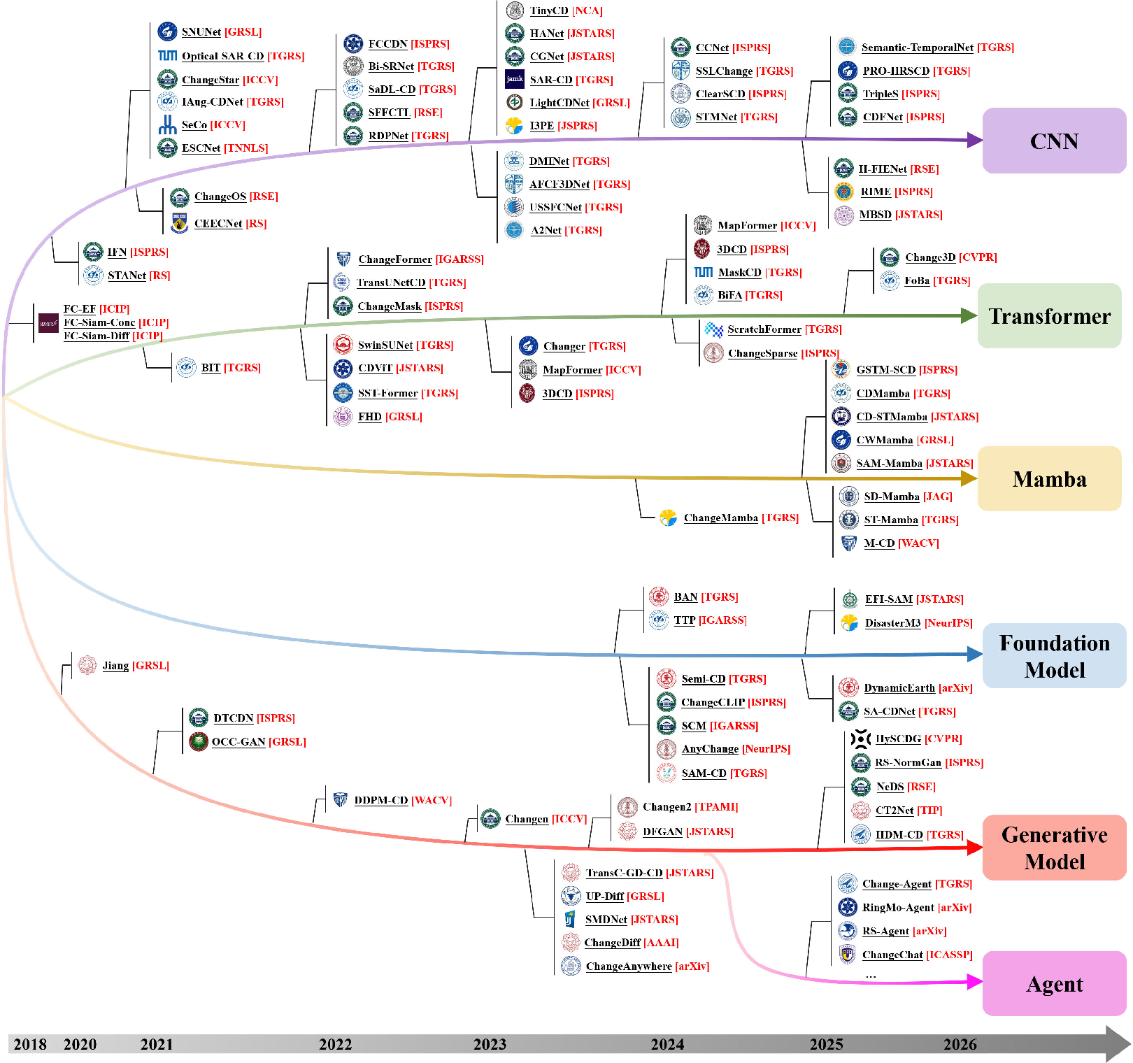
- Agent-based systems: Systems that use autonomous software agents (often powered by LLMs) to perform multi-step reasoning and interaction for analysis tasks. " {Agent}-based systems have integrated LLMs as reasoning engines for interactive change analysis"
- Binary change detection (BCD): The formulation of change detection that labels each pixel as changed or unchanged. "The predominant formulation of CD is binary change detection (BCD), which classifies each pixel as either changed or unchanged."
- Binary change mask: A pixel-level, two-class raster indicating where change occurred between two images. "a pixel-level binary change mask annotated by professional interpreters."
- Bi-temporal (setting): Using two time points (pre- and post-event) of imagery to analyze change. "Built upon 5{,}000 bi-temporal image pairs acquired by the Jilin-1 satellite"
- Building damage assessment (BDA): Task that labels the severity of building damage (e.g., minor/major/destroyed) in post-event imagery. "Semantic change detection (SCD) and building damage assessment (BDA) partially bridge this gap"
- Change area ratio (CAR): The proportion of changed pixels in an image pair, measuring how much of the scene changed. "the change area ratio (CAR)---defined as the proportion of changed pixels in each image pair"
- Change captioning (CC): Generating natural-language descriptions of changes observed between images. "change captioning (CC) and change question answering (QA)"
- Change detection visual question answering (CDVQA): A task where models answer natural-language questions specifically about detected changes. "change detection visual question answering (CDVQA) has emerged as a complementary task"
- Change question answering (QA): Answering questions in natural language about what changed, where, how much, etc., based on image pairs. "change captioning (CC) and change question answering (QA)"
- Closed taxonomy: A fixed, predefined set of classes used for labeling, without open-ended semantics. "discrete numerical class indices drawn from a closed taxonomy."
- Cross-modal fusion: Combining different sensing modalities (e.g., optical and SAR) to improve robustness and understanding. "cross-modal fusion of optical and SAR data enables all-weather, day-and-night monitoring"
- Cross-temporal attention: An attention mechanism that models relationships across time between images, e.g., pre- and post-event. "introduced global cross-temporal attention"
- Foundation model: Large pretrained models (e.g., CLIP, SAM) adapted to downstream tasks with minimal supervision. "Foundation model adaptations have enabled zero-shot and few-shot CD by transferring pretrained CLIP and SAM representations"
- Ground sample distance (GSD): The spatial resolution of imagery expressed as the ground length represented by one pixel. "0.5--0.75\,m ground sample distance"
- Hyperspectral (HS): Imaging with hundreds of narrow spectral bands, enabling fine spectral discrimination. "multispectral and hyperspectral sensors offer richer spectral discrimination for fine-grained change analysis"
- Instruction-tuning: Fine-tuning models with instruction–response pairs to enable better adherence to user prompts and multi-turn interactions. "instruction-tuning datasets have further extended the interaction to multi-turn conversational analysis"
- Land-cover: The physical material at the surface of the earth (e.g., water, forest, buildings) used to categorize scene content. "per-pixel land-cover annotations at both time phases"
- Mamba-based methods: Change detection models built on Mamba (state-space) architectures that offer linear-time sequence modeling. "{Mamba}-based methods achieved comparable perception at linear computational cost."
- Multi-modal LLM: An LLM that processes both images and text to generate or judge annotations. "multi-modal LLM generation"
- Multi-temporal monitoring: Analysis over more than two time points to track continuous change trajectories. "{multi-temporal} monitoring that tracks continuous change trajectories from dense satellite time series"
- Multispectral (MS): Imaging with several (typically 4–13) broad spectral bands, providing more spectral detail than RGB. "multispectral and hyperspectral sensors offer richer spectral discrimination"
- Ordinal damage scales: Ordered categories (e.g., none < minor < major < destroyed) used to quantify damage severity. "BDA further introduces ordinal damage scales (e.g., minor/major/destroyed)"
- Semantic change detection (SCD): Assigning semantic labels (classes) to changed areas, identifying what changed, not just where. "Semantic change detection (SCD) and building damage assessment (BDA) partially bridge this gap"
- Siamese paradigm: A two-branch neural architecture that processes pre- and post-event images in parallel before comparison. "established the dominant Siamese paradigm"
- Single-temporal change detection: Inferring changes using one image at a time by leveraging pretrained semantics and unpaired data. "{single-temporal} CD that exploits pretrained semantic representations to infer changes from unpaired imagery"
- Synthetic Aperture Radar (SAR): Active microwave imaging modality enabling day/night and all-weather observations. "cross-modal fusion of optical and SAR data enables all-weather, day-and-night monitoring"
- Very high resolution (VHR): Imagery with sub-meter spatial resolution. "VHR = Very High Resolution (1\,m)."
- Vision-grounded LLM judging: Using an LLM conditioned on images to evaluate the accuracy and quality of generated annotations. "vision-grounded LLM judging"
- Vision–LLMs (VLMs): Models that jointly process visual and textual information for tasks like captioning and VQA. "The advent of vision--LLMs (VLMs) has begun to close this gap."
Collections
Sign up for free to add this paper to one or more collections.