Pocket-SLAM: Rendering-Area-Aware Pruning for Memory-Efficient 3DGS-SLAM
Abstract: 3D Gaussian Splatting (3DGS) has garnered significant attention in Simultaneous Localization and Mapping (SLAM) due to its advances in capturing fine-grained geometry features and synthesizing novel views. For SLAM in large-scale scenes, such as autonomous driving, 3DGS-SLAM faces a critical limitation: memory consumption increases continuously over time as Gaussian points accumulate, leading to poor memory efficiency and limiting its applicability. In this work, we propose a rendering-area-aware pruning strategy that selectively removes Gaussians based on their contribution to the effective rendering area, rather than solely relying on Gaussian-level heuristics such as opacity or gradient magnitude. This perspective directly targets the sources of memory redundancy, effectively reducing the peak memory footprint of 3DGS-SLAM during runtime. Evaluations on the EuRoC and KITTI datasets demonstrate that our method consistently outperforms existing pruning approaches in large-scale outdoor scenes, achieving over 60% memory reduction and more than 2 times FPS improvement while preserving localization and mapping accuracy. These results highlight rendering-area-aware pruning as a promising direction for scaling 3DGS-SLAM to real-world autonomous driving scenarios. Our code is publicly available at https://github.com/UMN-ZhaoLab/Pocket-SLAM.git.



Paper Prompts
Sign up for free to create and run prompts on this paper using GPT-5.
Top Community Prompts
Explain it Like I'm 14
Pocket-SLAM: A simple explanation for teens
1. What is this paper about?
This paper is about making a 3D mapping and navigation system (called SLAM) use much less memory while staying accurate and fast. It focuses on a newer kind of 3D map called “3D Gaussian Splatting,” which represents the world with lots of soft, colored “blobs” in 3D. The problem is that, in big outdoor places (like city streets), the number of blobs keeps growing and eats up computer memory. The authors introduce Pocket-SLAM, a way to smartly “trim” unhelpful blobs so the system fits in memory and runs faster—without losing mapping and tracking quality.
2. What questions did the researchers ask?
- How can we stop memory from ballooning when mapping large outdoor areas with 3D Gaussian Splatting?
- How do we decide which 3D “blobs” are important enough to keep and which ones we can safely remove?
- Can we cut memory and boost speed while keeping the same (or better) accuracy for camera tracking and scene reconstruction?
3. How did they do it? (Methods in everyday language)
First, a quick idea of the basics:
- SLAM (Simultaneous Localization and Mapping) is like a traveler using a camera to both figure out where they are and build a map at the same time.
- 3D Gaussian Splatting represents the world with many fuzzy 3D blobs (think of them as tiny, soft paint dots in space). When you look through the camera, those blobs “splat” onto the image to create the view.
The paper adds two main ideas to cut memory:
- Rendering-area–aware pruning:
- Imagine each blob “covers” some amount of the camera image—like how much of the picture it actually influences.
- If a blob hardly affects what you see, it’s likely not very important for the final image or for tracking where the camera is.
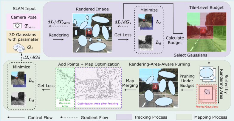
- The method measures how much of the image each blob influences (its “rendering area”) and removes the ones that contribute very little. This directly targets blobs that don’t help what you see.
- Tile-level budget mechanism:
- If you only remove small-coverage blobs, you might accidentally wipe out tiny-but-important details in texture-rich areas (like trees, signs, or building edges).
- To prevent that, the image is split into a grid of tiles (like a checkerboard). Each tile gets a “budget” for how many blobs it should keep.
- The budget is based on how useful that region is for tracking (simplified: if the camera relies on a region a lot to figure out its position, that region gets a bigger budget).
- This keeps a balanced number of blobs across the image—saving memory while protecting both big smooth areas (like road or sky) and detailed areas (like foliage or façades).
How it fits into SLAM:
- Tracking: the system adjusts the camera’s position to match the current view. Here, it also measures how “informative” each image tile is to set per-tile budgets.
- Mapping: the system refines the 3D blobs. After mapping, it prunes (removes) blobs using the rendering-area rule while respecting each tile’s budget.
Analogy:
- Think of packing a backpack for a long trip. Each item (blob) takes space (memory). You keep the items you actually use the most when you look in the pack (rendering area), but you also make sure each category (tile) gets some space—so you don’t end up with all shirts and no socks (balanced tile budgets).
4. What did they find and why is it important?
Main results (on popular datasets EuRoC and KITTI):
- Over 60% less memory used.
- More than 2× faster frame rate (FPS).
- Tracking accuracy (how well the system knows where the camera is) and mapping quality (how good the rendered view looks) stayed as good as the strong baseline—and sometimes improved.
Why this matters:
- Outdoor scenes (roads, sky, wide surfaces) often have big areas that many blobs try to cover. By focusing on blobs that actually shape what you see, and protecting detailed regions with tile budgets, the system removes lots of unnecessary data.
- Less memory and higher speed mean the system can run on smaller, cheaper computers (like the ones in cars or drones) and handle larger areas without crashing or slowing down.
Terms made simple:
- ATE (Absolute Trajectory Error): how far the estimated path is from the true path (lower is better).
- PSNR/SSIM/LPIPS: scores that measure how close the rendered images are to real photos (higher PSNR/SSIM and lower LPIPS are better). The method kept these solid.
5. What’s the impact of this research?
- Practical deployment: Pocket-SLAM makes advanced 3D mapping feasible on devices with limited memory (like embedded GPUs in robots, drones, and self-driving cars).
- Longer, larger missions: Because memory grows more slowly, SLAM can map bigger spaces without running out of resources.
- Plays well with others: The pruning strategy can be combined with other speed-up tricks for even better performance.
- Future possibilities: Smarter, adaptive pruning that changes with scene complexity (day vs. night, weather, seasons) could make robots even more reliable in the real world.
In short: Pocket-SLAM is like a smart organizer for 3D maps. It keeps what’s important for what the camera actually sees and needs, spreads detail across the whole view, and throws away the rest—so the system runs faster, uses less memory, and stays accurate.
Knowledge Gaps
Knowledge gaps, limitations, and open questions
Below is a consolidated list of unresolved issues and concrete directions that remain open based on the paper’s methods, experiments, and claims:
- Unclear availability and source of depth supervision: the loss uses D_t, but the paper does not specify whether depth comes from stereo, LiDAR, or self-supervision, nor how the method behaves when depth is absent or noisy.
- Viewpoint bias in pruning signal: rendering-area scores are computed per current frame; there is no multi-view or temporal aggregation to prevent pruning Gaussians that are unimportant now but crucial from future viewpoints.
- Lack of occlusion-aware importance: the coverage metric does not incorporate visibility/transmittance (alpha compositing) along rays, risking mis-ranking occluded Gaussians that could become visible later.
- No analysis of tile-grid design: tile size, aspect, and alignment choices are not specified or ablated, leaving open how grid resolution impacts pruning balance, accuracy, and runtime.
- Heuristic budgets without sensitivity analysis: N_tar, B_min, B_max are fixed; there is no study of sensitivity, robustness across scenes, or guidance for automatic tuning.
- Missing adaptive pruning schedule: pruning is triggered after mapping convergence, but the optimal frequency, schedule, and hysteresis to minimize memory spikes and accuracy loss are not studied.
- Handling of newly inserted Gaussians: newly added Gaussians are exempt from pruning until later, but worst-case transient memory peaks and mitigation strategies are not quantified.
- Computational overhead not characterized: there is no complexity or profiling of the coverage computation per Gaussian/tile, nor scaling analysis for tens of millions of Gaussians.
- Limited hardware evaluation: results are on an NVIDIA A6000; there is no empirical validation on embedded/edge GPUs (e.g., Jetson Orin) or energy/per-watt efficiency measures.
- Real-time readiness: achieved FPS (≈2–4) is below practical real-time rates for autonomous driving; it remains unclear what algorithmic or systems changes are needed to reach ≥10–30 FPS.
- Generalization to dynamic and long-term scenarios: the approach is not evaluated with moving objects, night-time, seasonal/weather changes, or lifelong mapping with repeated revisits.
- Effect on loop closure and relocalization: pruning’s impact on loop detection, pose graph optimization, and re-localization robustness (especially after long gaps) is not analyzed.
- Over-preservation of large low-texture regions: prioritizing large rendering areas (e.g., sky/road) may not yield strong geometric constraints; a failure-mode analysis and countermeasures are missing.
- Geometry-centric evaluation is absent: beyond PSNR/SSIM/LPIPS and ATE, there is no depth/3D error, surface accuracy/coverage, or structural completeness assessment of the reconstructed map.
- Sequence 01 on KITTI: all methods fail, but there is no diagnosis of failure modes or targeted remedies (e.g., high-speed highway scenes with low parallax).
- Resolution/FOV dependence: the pruning criterion depends on pixel coverage, but the effects of camera resolution, FOV, and scaling across sensor setups are not explored.
- Semantic awareness: the method is purely photometric/coverage driven; integrating semantics could help preserve safety-critical or task-relevant structures—this is not investigated.
- Robustness to photometric variation: the approach assumes photometric consistency; behavior under exposure changes, HDR, rolling shutter, or non-Lambertian effects is not examined.
- Interaction with other accelerations: although claimed orthogonal, combinations with quantization, feature sparsification, voxel hashing, or compressed splat parameterizations are not empirically validated.
- Reproducibility details: “multi-modality priors” for pose initialization and the exact GPU memory accounting methodology (e.g., framework caching, allocator behavior) are not fully specified, hindering fair reproduction and comparison.
Practical Applications
Immediate Applications
The following applications can leverage Pocket-SLAM’s rendering-area–aware pruning and tile-level budget mechanism today, using the released code and demonstrated performance (≈60% peak memory reduction and >2× FPS) on EuRoC and KITTI.
- On-board SLAM for autonomous ground vehicles — robotics, automotive
- What: Deploy 3DGS-SLAM on embedded GPUs in AVs to maintain accurate localization and dense mapping while meeting strict memory budgets.
- Potential tools/products/workflows: ROS2-integrated “Pocket-SLAM node”; drop-in module for LGS-SLAM/GS-SLAM; AV perception stack plugin that enforces per-tile Gaussian budgets during runtime.
- Assumptions/dependencies: Outdoor scenes with large rendering areas (roads/sky) match assumptions; GPU needed (Jetson Orin-class or better); integration with existing 3DGS-SLAM pipeline.
- Real-time UAV site mapping and inspection — construction, infrastructure, public safety
- What: Larger-area, longer-duration flights with on-board mapping (bridges, roads, powerlines) due to lower memory pressure and higher FPS.
- Potential tools/products/workflows: UAV inspection workflows that keep mapping on-device instead of streaming to cloud; mission planners that set target Gaussian counts per sortie.
- Assumptions/dependencies: Stable lighting/motion; monocular or stereo input and camera calibration; parameter tuning for tile budgets per environment.
- Outdoor delivery and security robots — logistics, facilities
- What: Robust, memory-efficient mapping in campuses/parks with texture-sparse areas; fewer out-of-memory failures and smoother operation.
- Potential tools/products/workflows: Fleet management dashboards that monitor peak memory and pruning ratios; OTA updates adding Pocket-SLAM to existing carts/UGVs.
- Assumptions/dependencies: Scenes align with KITTI-like statistics; sufficient GPU headroom; robust re-localization in repetitive areas still depends on loop closure.
- Mobile AR mapping at neighborhood/campus scale — consumer apps, AR/VR
- What: On-device scene capture outdoors (parks, courtyards) with reduced memory and improved runtime; supports larger AR sessions without frequent resets.
- Potential tools/products/workflows: SDK extension for AR engines to use 3DGS-SLAM + area-aware pruning; background “map maintenance” thread enforcing tile budgets.
- Assumptions/dependencies: Mobile-class GPUs/NPUs support 3DGS rendering/training; battery/thermal limits; alignment with AR frameworks’ camera/depth pipelines.
- Cost-efficient cloud/offline mapping — software, cloud operations
- What: Process large outdoor datasets on smaller GPU instances by lowering peak memory, reducing compute cost and job failures.
- Potential tools/products/workflows: Batch SLAM pipelines with “peak memory watchdog” and auto-pruning schedules; CI benchmarks tracking ATE/PSNR vs. memory.
- Assumptions/dependencies: Access to 3DGS-SLAM codebase and training data; tuning global target Gaussian counts per sequence.
- Agricultural field mapping and navigation — agri-robotics
- What: Efficient mapping over homogeneous fields (texture-sparse) where tile budgets prevent over-pruning, maintaining usable maps for row-following and coverage.
- Potential tools/products/workflows: Row-crop robots with memory-aware SLAM; field scouting UAVs with on-board map compression.
- Assumptions/dependencies: Seasonal appearance change not yet addressed; lighting and wind-induced motion may need adaptive schedules.
- Academic benchmarking and method development — academia
- What: A stronger baseline to study memory/runtime trade-offs in 3DGS-SLAM at scale; reproducible code for ablations.
- Potential tools/products/workflows: Course labs on SLAM efficiency; benchmark suites reporting ATE/PSNR/peak-memory; integration tests with other 3DGS accelerations.
- Assumptions/dependencies: Familiarity with 3DGS pipelines; GPU availability for per-frame rendering/backprop.
- Procurement and deployment guidance — policy, standards
- What: Immediate updates to RFPs and deployment checklists to include peak-memory caps and runtime pruning policies for SLAM stacks on edge platforms.
- Potential tools/products/workflows: “Memory headroom” safety margins in AV/robot pilots; compliance tests that stress peak memory across routes.
- Assumptions/dependencies: Organizational readiness to adopt technical criteria; mapping stack is 3DGS-based.
Long-Term Applications
These applications are feasible with further research, integration, or scaling (e.g., dynamic scenes, adverse conditions, hardware co-design, standardization).
- Automotive-grade 3DGS-SLAM for L2–L4 autonomy — automotive
- What: Production SLAM with rendering-area–aware memory control that operates across cities, seasons, and night-time conditions.
- Potential tools/products/workflows: ISO-like test suites for peak-memory stability; production-grade Pocket-SLAM SDK with safety monitoring and failover.
- Assumptions/dependencies: Robustness to weather/night/occlusions; integration with HD maps, radar/LiDAR; safety certification.
- City-scale AR cloud mapping — AR cloud, mapping
- What: Persistent outdoor AR maps built on memory-efficient Gaussian representations, enabling scalable capture and updates.
- Potential tools/products/workflows: Cloud services that fuse user/device scans and enforce per-region budgets; auto-retirement of redundant Gaussians as scenes evolve.
- Assumptions/dependencies: Multi-user alignment and privacy; lifelong mapping under appearance change; storage/versioning policies.
- Multi-sensor, lifelong SLAM with dynamic budget adaptation — robotics
- What: Budgets that adapt over time using gradients from cameras+LiDAR+IMU; prevent drift while keeping memory bounded in lifelong operation.
- Potential tools/products/workflows: “Budget controller” that reallocates per-tile limits by scene entropy and motion; scheduled pruning/refresh cycles.
- Assumptions/dependencies: Sensor fusion design; handling moving objects; online recalibration.
- Hardware–algorithm co-design for Gaussian SLAM — semiconductors, edge AI
- What: Accelerators that prioritize splats by rendering-area importance and tile budgets for efficient memory bandwidth and compute.
- Potential tools/products/workflows: Compilers/schedulers using coverage scores; custom memory hierarchies for Gaussian tiles (e.g., GauSPU-like).
- Assumptions/dependencies: Hardware ecosystem adoption; standardized kernels/APIs for 3DGS.
- Energy-aware autonomy with memory budgets — energy, sustainability
- What: Extend battery life by reducing memory traffic and compute via aggressive but safe pruning; dynamic power–accuracy trade-offs.
- Potential tools/products/workflows: Energy controllers that tune N_tar and B_min/B_max by battery SoC and mission criticality.
- Assumptions/dependencies: Accurate power models; closed-loop controllers balancing ATE/PSNR with power.
- Indoor–outdoor campus navigation for service robots — healthcare, hospitality, campuses
- What: Seamless transitions between texture-rich indoor and texture-sparse outdoor areas using tile budgets to avoid catastrophic over-pruning.
- Potential tools/products/workflows: Campus-wide maps with per-zone budget profiles; escalated preservation for critical interior landmarks.
- Assumptions/dependencies: Validation indoors; robust loop closure and relocalization across domains; safety/regulatory approval in hospitals.
- Standardization of SLAM “peak-memory safety” metrics — policy, certification
- What: Regulatory or industry metrics that require SLAM to stay below specified peak memory with demonstrated headroom under stress.
- Potential tools/products/workflows: Conformance tests using EuRoC/KITTI-like trials; certification artifacts documenting pruning policies and failure modes.
- Assumptions/dependencies: Multi-stakeholder buy-in; test track and data availability; interoperability across SLAM variants.
- Content creation and VFX previsualization at outdoor scale — media/entertainment
- What: On-set outdoor scans with fast, memory-bounded 3DGS-SLAM for previz and layout in large environments.
- Potential tools/products/workflows: DCC tool plugins that import Gaussian scenes; “live map” monitors showing tile densities and pruning status.
- Assumptions/dependencies: Artistic quality targets (SSIM/LPIPS) met under aggressive pruning; device portability/thermal limits on set.
Notes on feasibility across applications:
- The approach excels in large outdoor scenes where rendering-area signals align with important structures (roads/sky). Indoor-only deployments may require retuned budgets and validation.
- GPU acceleration is assumed; CPU-only operation is unlikely to meet real-time requirements.
- Dynamic scenes, severe lighting changes, and nighttime conditions were not evaluated and may require adaptive pruning schedules and/or sensor fusion.
- Integration depends on a 3DGS-SLAM pipeline; point-cloud- or NeRF-only stacks need bridging layers or hybrid designs.
Glossary
- 3D Gaussian Splatting (3DGS): A neural rendering technique that represents scenes using many anisotropic 3D Gaussian primitives for fast, high-quality view synthesis and geometry. "3D Gaussian Splatting (3DGS) has garnered significant attention in Simultaneous Localization and Mapping (SLAM)"
- Absolute Trajectory Error (ATE): A metric that measures the difference between estimated and ground-truth camera trajectories, typically reported as RMSE. "(Absolute Trajectory Error Root Mean Square Error, ATE)"
- Bundle Adjustment (BA): A nonlinear optimization that jointly refines camera poses and scene structure to minimize reprojection error. "global BA"
- Covariance: In this context, the 3D or 2D Gaussian covariance matrix that encodes the shape and uncertainty (or spread) of a Gaussian primitive or its image-plane projection. "position, covariance, opacity, and color parameters."
- Depth loss: A loss term that penalizes the discrepancy between predicted and observed depth, used to improve geometry and pose estimation. "We then define the photometric loss and depth loss as:"
- EuRoC MAV dataset: A benchmark dataset for visual SLAM and VO, featuring challenging motions and lighting, used to evaluate tracking and reconstruction. "The EuRoC MAV dataset~\cite{EUROC} includes outdoor sequences MH01âMH05"
- Feature warping: A tracking cue that aligns features across frames by warping them with the current pose estimate to compute a loss for optimization. "feature warping losses (tracking)"
- Frames per second (FPS): A performance metric indicating how many frames a system processes or renders per second. "We use frames per second (FPS) and peak memory consumption as evaluation metrics."
- Gaussian primitives: Parametric Gaussian elements (with position, covariance, color, etc.) that serve as the basic building blocks of 3DGS scene representations. "integrated Gaussian primitives into SLAM systems."
- Gaussian pruning: The process of removing Gaussians deemed unimportant to reduce memory and computation while preserving rendering and tracking quality. "recent research has focused on Gaussian pruning."
- Hat operator: The operator mapping a 6D vector in se(3) to its 4x4 matrix representation, used in Lie algebra-based pose updates. "hat operator."
- Keyframe: Selected frames stored for long-term optimization and mapping (e.g., inserting/refining Gaussians), rather than processing every frame equally. "Keyframes are then selected to refine the scene and insert new Gaussians (mapping)."
- KITTI odometry dataset: A large-scale driving dataset widely used to benchmark odometry and SLAM in outdoor urban and suburban environments. "The KITTI odometry dataset~\cite{KITTI} provides large-scale outdoor driving sequences"
- Learned Perceptual Image Patch Similarity (LPIPS): A learned metric that quantifies perceptual differences between images based on deep features. "learned perceptual image patch similarity (LPIPS)"
- Lie algebra: The tangent-space representation (se(3)) used to update poses via exponential mapping in a stable, minimal parameterization. "The pose update is performed in Lie algebra form:"
- LiDAR-based systems: SLAM/odometry approaches that rely on laser scanning sensors to estimate motion and map environments. "LiDAR-based systems~\cite{Lidar1,Lidar2}"
- Masking–then–pruning: A two-stage strategy that first deactivates (masks) low-importance Gaussians before permanently removing them. "masking--then--pruning scheme"
- Monocular SLAM: SLAM methods that use a single camera stream to estimate poses and reconstruct scenes. "combining 3DGS with monocular SLAM"
- Opacity: In rendering, the per-Gaussian transparency parameter controlling its contribution to the final pixel color. "prunes Gaussians based on opacity"
- ORB-SLAM: A feature-based SLAM system using ORB features for robust tracking, mapping, and loop closure. "ORB-SLAM~\cite{orbslam} modules"
- Peak Signal-to-Noise Ratio (PSNR): A standard metric (in dB) for evaluating reconstruction or rendering fidelity relative to ground-truth images. "peak signal-to-noise ratio (PSNR)"
- Photometric loss: A loss term that penalizes discrepancies between rendered and observed RGB intensities to guide pose and map optimization. "We then define the photometric loss "
- Projected mean: The mean of a 3D Gaussian after projection onto the image plane, indicating its center in pixel coordinates. "projected mean and covariance."
- Rendering-Area--Aware Pruning: A pruning strategy that ranks and removes Gaussians based on their effective pixel coverage (rendered area) in the image. "Rendering-Area--Aware Pruning removes low-contribution Gaussians after mapping optimization"
- Robust penalty functions: Loss functions (e.g., Huber) that reduce the influence of outliers when optimizing photometric/depth errors. "and are robust penalty functions."
- Root-Mean-Square Error (RMSE): The square root of the mean squared error, often used to summarize trajectory or depth errors. "root-mean-square error (RMSE) of the absolute trajectory error (ATE)"
- SE(3): The Special Euclidean group of 3D rigid-body motions (rotation and translation) used to represent camera poses. "We denote the camera pose as $T_{\mathrm{cam} \in SE(3)$"
- Structural Similarity Index (SSIM): An image-quality metric assessing structural similarity between two images on a [0,1] scale. "structural similarity index (SSIM)"
- Tile-Level Budget Mechanism: A per-image-region (tile) allocation that limits pruning locally to preserve detail in texture-dense areas while reducing redundancy elsewhere. "The Tile-Level Budget Mechanism assigns balanced survival budgets during tracking to guide pruning"
Collections
Sign up for free to add this paper to one or more collections.