- The paper demonstrates that SGL imaging can resolve Earth-like exoplanets using a detailed simulation pipeline incorporating photon statistics and sub-ppm calibration.
- It quantifies mission requirements by modeling instrumental noise, cloud-induced variability, navigation errors, and the convolutional 1/ρ response of the SGL.
- It shows that proper temporal sampling and dynamic inversion enable recovery of surface details at resolutions of 200–230 km under realistic conditions.
Direct Imaging of Earth-like Exoplanets with the Solar Gravitational Lens: A Technical Analysis
Introduction
This paper presents a comprehensive, scalar, aperture-averaged benchmark modeling the feasibility and limitations of direct, high-resolution imaging of Earth-like exoplanets using the Solar Gravitational Lens (SGL) (2606.14899). The study focuses on realistic end-to-end system constraints: image-plane sampling, photon statistics, systematic and random noise, instrumental and astrophysical backgrounds, temporal variability, navigation error, and numerical regularization. It establishes quantitative mission and inversion requirements and provides a basis for assessing whether SGL-enabled imaging architectures can achieve spatial resolutions and signal-to-noise ratios unattainable through conventional techniques.
SGL Imaging Framework and Forward Modeling
SGL imaging leverages the Sun's gravitational field to provide diffraction-limited angular resolution (sub-nanoarcsecond) and significant optical gain for background-limited observations. However, the SGL's extended and convolutional response—effectively a broad, aperture-averaged 1/ρ tail—means that unlike a conventional telescope, the source's image is spread into an Einstein ring that must be carefully sampled and algorithmically inverted.
The simulation pipeline initiates with a real, high-resolution Earth image, preprocessed to scalar luminance on a 128×128 grid. This image is forward-modeled through the SGL kernel, incorporating the projected cylinder geometry, photon-counting regimes for both planet and dominating coronal backgrounds, and a comprehensive suite of noise and systematics. Instrumental and physical effects injected into the modeling pipeline include rotational and cloud-induced temporal variability, finite-exposure smearing, navigation errors, calibration and coronagraphic residuals, and operator (PSF) mismatches. The resulting measurements are subject to a regularized Fourier/Wiener inversion process to test recoverability (see Figure 1 and Figure 2).
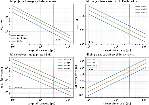
Figure 1: Target-distance and sampling scalings for SGL imaging—showing the key dependencies of image-plane coverage, sampling pitch, SNR, and dwell benchmarks.
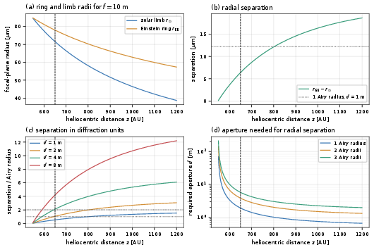
Figure 2: Einstein-ring extraction as an optical-propagation challenge—illustrating focal-plane geometry, separation challenges, and effective aperture constraints.
Systematic Limitations and Error Budget
Contrary to the simple notions of lens-based 'super-resolution', this benchmark demonstrates that the dominant limitations on SGL imaging are not directly imposed by the solar gravitational PSF's width, but by a confluence of systematic factors:
- Temporal Sampling and Planet Variability: Rotational smearing and ephemeral cloud cover destroy the stationarity assumption of simple deconvolution, necessitating time-tagged, phase-registered coaddition and dynamic inversion.
- Solar Corona and Detector Calibration: The coronal background, although subtractable in mean, introduces shot noise orders of magnitude higher than the exoplanet signal (Qcor/Qexo≈7.7×104 for the fiducial case), making ppm-level calibration residuals essential.
- Metrology and Navigation: Meter-level knowledge of image-plane coordinates is required due to the ∼10 m pixel scale, strongly constraining navigation and post-facto coordinate registration.
- Operator Fidelity: Accurate knowledge and modeling of the SGL PSF (including multipole and extended-Sun effects) are prerequisite for unbiased reconstruction.
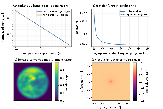
Figure 3: SGL optical response diagnostics and the derived inverse problem's conditioning.
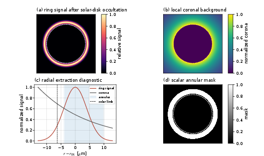
Figure 4: Instrument-plane annular photometry—analyzing signal and coronal backgrounds in practical extraction geometry.
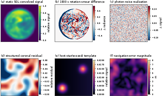
Figure 5: Forward-model perturbations illustrating injected noise, systematics, and navigation error profiles.
Reconstruction, Regularization, and Cloud Mitigation
Reconstruction in this context is fundamentally ill-posed, with the 1/ρ SGL kernel leading to substantial noise amplification for high-spatial-frequency content. The scalar benchmark implements a regularized Wiener inverse on the guard-padded grid, with support and positivity constraints, guided by the discrepancy principle for regularization parameter selection. Finite photon statistics, navigation uncertainty, and calibration precision critically dictate the achievable spatial contrast and detail.
The analysis makes explicit that static one-pass rasterization is fundamentally incompatible with imaging dynamic, rotating, cloudy planets—even in scenarios of high photon SNR. This is exemplified by the C3 branch, where failure to account for temporal evolution manifests as catastrophic aliasing and loss of surface detail. Mitigation strategies (C3b, C3c) rely on repeated, registered, short-exposure sampling, robust handling of clouded pixels, and joint estimation of persistent and transient map components using phase registration and robust statistical coaddition.
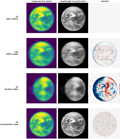
Figure 6: Stepwise reconstructions across noise-free, smeared, temporally incoherent, and photon-noise-degraded scenarios—demonstrating dominant degradation modes.
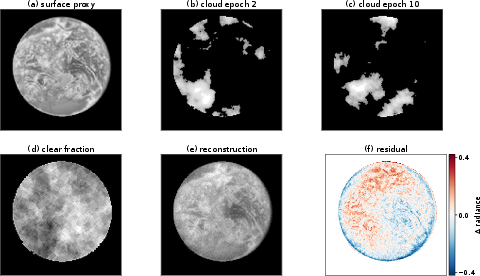
Figure 7: Stochastic cloud-field stress test (C3c)—showing surface proxy, independent synthetic cloud epochs, and the recovered persistent map.
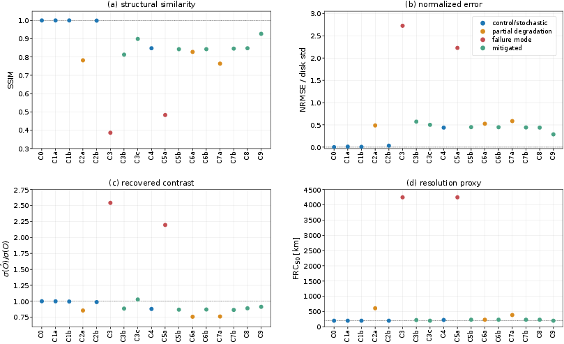
Figure 8: Structure similarity, error, contrast recovery, and spatial resolution (FRC50) across all discrete simulation test cases.
Quantitative Numerical Results
In the fiducial 1m, 128×128 raster, Earth at 30pc is compressed to a $1.338$ km image cylinder (128×1280 m sampling pitch). The dominant photon-limited branch achieves post-reconstruction 128×1281 and SSIM128×1282 (C8), with Fourier-ring-correlation resolution proxies of 128×1283–128×1284 km, conditional on all mitigation factors. Elevating the photon statistics (C9) yields 128×1285 and SSIM128×1286.
Cloud-mitigation demonstrations (C3b/C3c, 128×1287 phase-registered epochs per longitudinal bin) achieve recovery of persistent surface-like proxies with SSIMs of 128×1288–128×1289 at comparable spatial resolution floors; they also quantify the required temporal redundancy, demonstrating that Qcor/Qexo≈7.7×1040 yields manageable Qcor/Qexo≈7.7×1041 yr single-spacecraft dwell per map, or Qcor/Qexo≈7.7×1042 d with 16 parallel spacecraft.
Calibration residuals on the coronal signal must not exceed sub-ppm levels, as Qcor/Qexo≈7.7×1043 ppm artifacts can completely compromise map fidelity (Qcor/Qexo≈7.7×1044 planet units; C5a failure mode). Proper metrology keeping residual jitters below Qcor/Qexo≈7.7×1045–Qcor/Qexo≈7.7×1046 m is essential to prevent spatial and photometric bias.
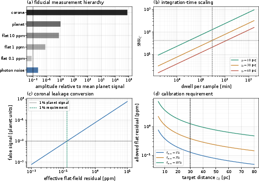
Figure 9: SNR/calibration error budget—demonstrating the translation between flat-field residuals, allowed signal artifacts, and practical calibration constraints.
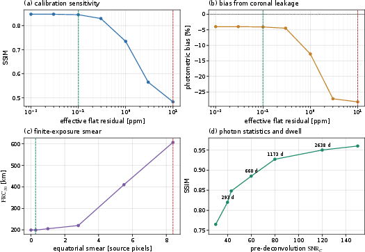
Figure 10: Requirement sweeps—illustrating the scalar system's sensitivity to calibration, exposure, and photon-count budgets.
SGL vs Conventional Architectures and Mission Implications
The paper juxtaposes SGL imaging against theoretical conventional architectures (filled apertures, starshades, interferometers), showing that conventional telescopes require prohibitive apertures (Qcor/Qexo≈7.7×1047100 km) and integration times per spatial element, making them impractical for surface mapping at tens of parsecs. In contrast, the SGL's gain and angular response shift the burden to spacecraft propulsion, optical background suppression, instrumental calibration, platform metrology, and dynamic inversion.
Mission designs favor interleaved, multiple-spacecraft architectures capable of repeated, temporally resolved sampling to facilitate cloud/statistical averaging and to compress the observing schedule. The required photon time for surface map recovery is set by the product of image-plane samples and independent, cloud-mitigated visits, scaling inversely with collector area and directly with the number of epochs and phase bins.
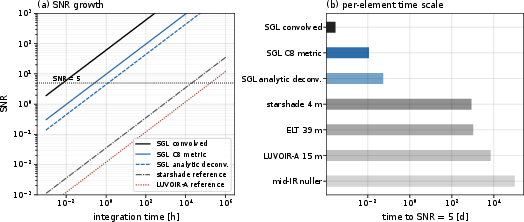
Figure 11: SGL SNR build-up vs time and comparison with representative conventional remote-imaging scalings—highlighting the orders-of-magnitude efficiency separation.
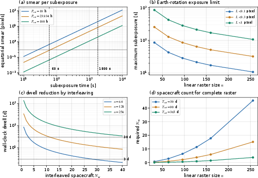
Figure 12: Temporal sampling and architecture requirements showing trade-offs in dwell time, pixel size, and spacecraft count for mission design.
Limitations and Directions for Future Work
While the scalar, aperture-averaged model sets physically transparent requirements and demonstrates recoverability under stringent calibration and temporal control, the following major extensions are needed:
- Full wave-optical PSF incorporation (solar multipoles, plasma, extended Sun).
- Scene models including time-tagged, multispectral general-circulation radiative transfer outputs for realistic clouds and atmospheric structure.
- End-to-end detector modeling, including cosmic rays, persistence, and calibration error propagation.
- Closed-loop navigation/ephemeris estimation.
- Dynamic, Bayesian inversion of time-tagged, phase-resolved data streams jointly estimating persistent maps and nuisance states.
- Physical modeling and mitigation of host-star/exozodiacal leakage with coronagraphic/external occulter propagation.
The research pathway is thus well-specified by the operator formalism and requirements articulated in the benchmark.
Conclusion
This paper establishes, through explicit simulation and controlled degradations, that the Solar Gravitational Lens can theoretically yield resolved Qcor/Qexo≈7.7×1048–Qcor/Qexo≈7.7×1049 km class maps of Earth analogs at ∼100 pc, conditional on stringent instrumental, calibration, and temporal requirements. Core limitations are not set by the gravitational kernel's width, but by the necessity for photon-limited calibration, dynamic inversion for temporal variability, sub-ppm background control, and precise image-plane metrology. Under the scalar model and stated mitigations, persistent surface information is statistically recoverable, but future mission planning and evaluation must incorporate multifactor dynamic models, physical scene representations, and full joint inversion methodologies.
The SGL is, therefore, a technically plausible high-resolution imaging system for exoplanetary science, provided that mission architectures can meet the quantitative requirements in calibration, temporal sampling, navigation, and dynamic inference identified by this work.