- The paper proposes a decentralized LiDAR-SLAM system that integrates a certifiably optimal pose graph optimization backend using RBCD to ensure globally optimal trajectories.
- The paper validates its approach with split-trajectory experiments, demonstrating RMSE reductions of up to 48.9% compared to state-of-the-art systems.
- The paper shows that employing dual certificates effectively eliminates local minima, enhancing robustness in GNSS-denied and degenerate environments.
Decentralized LiDAR-SLAM with Certifiably Optimal Pose Graph Optimization
Introduction
Decentralized multi-robot LiDAR-SLAM is indispensable for collaborative mapping and localization tasks in GNSS-denied environments, particularly due to its scalability and robustness. However, accumulation of drift, especially in under-constrained directions, and suboptimal convergence in large-scale or degenerate operating environments present severe limitations for existing decentralized SLAM frameworks. Most notably, prevalent systems employ local search-based optimization or rely on one-off coordinate alignment strategies for inter-robot registration, which are structurally vulnerable to local minima and fail to guarantee global consistency. The paper "A Decentralized LiDAR-SLAM System with Certifiably Optimal Pose Graph Optimization" (2605.25051) addresses these issues by proposing a fully decentralized LiDAR-SLAM pipeline that, for the first time, incorporates a certifiably optimal PGO backend using the RBCD algorithm to ensure joint trajectory global optimality.
System Architecture
The framework is composed of a modular peer-to-peer architecture that processes point clouds and odometry from LIO-SAM frontends on each agent. Frontend modules employ Scan-Context descriptors for efficient loop closure detection and a P2P protocol for geometric constraint synchronization between agents. The core differentiator lies in the backend, where, instead of conventional local-search or rigid registration, the system formulates a continuous global PGO encompassing all intra- and inter-robot constraints. This optimization is cast as an SDP problem optimized on the Stiefel manifold via RBCD, which generates a dual certificate for verifying global optimality and detecting degenerate local minima.
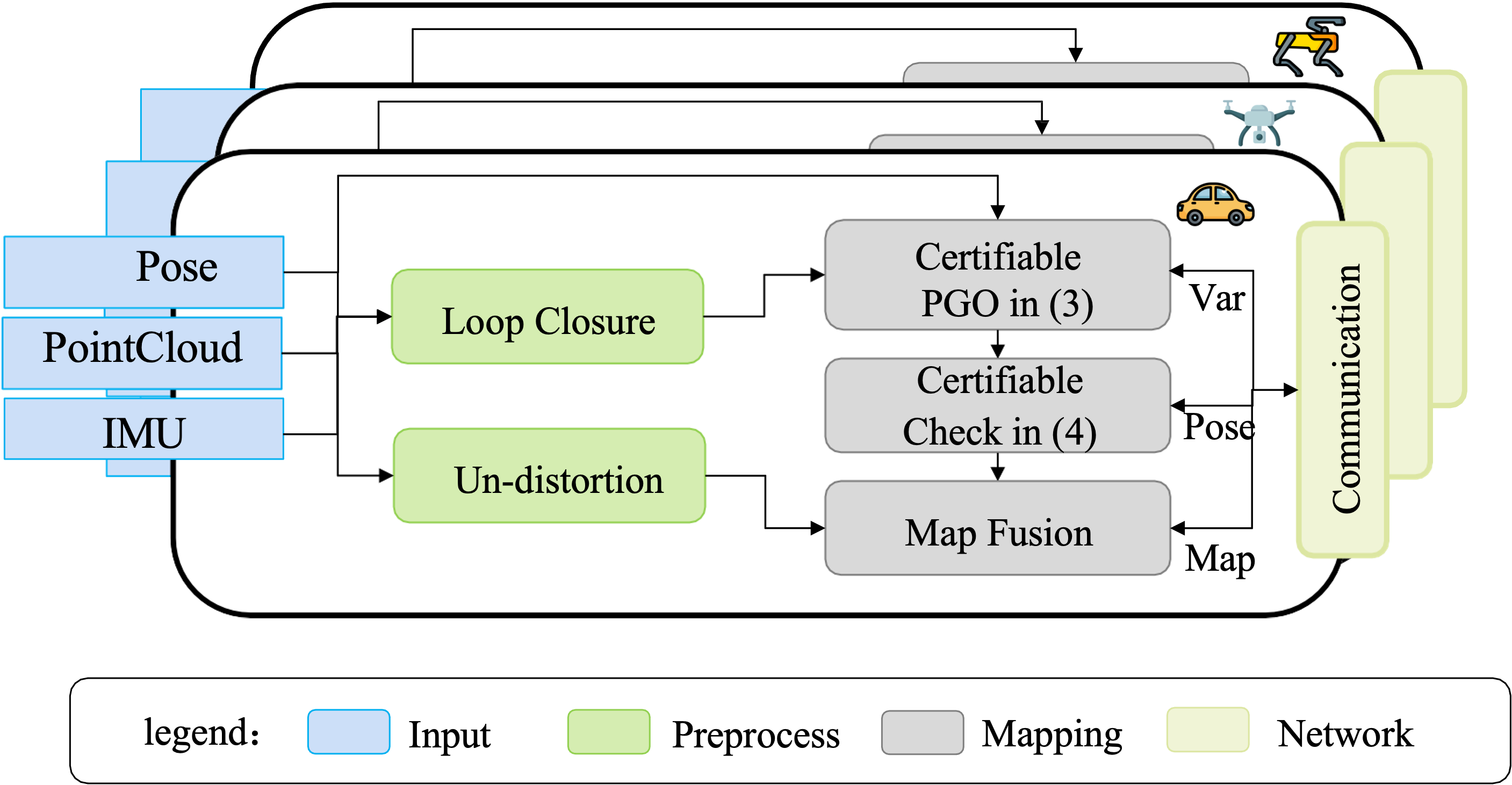
Figure 1: Pipeline of the proposed system, highlighting the certifiably optimal PGO backend as the key innovation relative to DiSCo-SLAM.
This design maintains scalability and front-end efficiency while enabling robust, globally consistent batch PGO and volumetric mapping.
Certifiably Optimal Multi-Robot Trajectory Estimation
Local search-based backends, exemplified by DiSCo-SLAM, apply a one-time rigid transform alignment for inter-robot map merging but suffer from two primary flaws: (1) the single registration event is vulnerable to failure in ambiguous environments and (2) subsequent inter-robot constraints are ignored, causing irretrievable drift. In contrast, the proposed framework maintains a comprehensive pose graph G=(V,E) encapsulating all agents' poses and constraints. The backend objective jointly optimizes all robot poses over SE(3), with each new inter-robot encounter incrementally refining the global trajectory, thereby propagating corrections system-wide and eliminating the reliance on initial guess quality.
The non-convex PGO problem is recast as a semidefinite relaxation, solved with RBCD, which yields a dual certificate matrix S∗. If the relaxation is tight, certified by the (d+1)-th eigenvalue λd+1(S∗)>0 for d=3, the solution is globally optimal. This certifiability addresses degenerate observability scenarios in a principled way: the system can automatically detect and discard non-global solutions, thereby ensuring structural trajectory integrity throughout operation.
Experimental Validation and Quantitative Results
To evaluate the system, the authors conduct split-trajectory experiments with overlapping LiDAR datasets, treating them as two agents in a decentralized setting. Deployments use high-density Ouster LiDAR, tactical-grade IMUs, and GNSS/IMU for ground-truth. Comparisons against DiSCo-SLAM and raw LIO-SAM odometry demonstrate the practical impact of certifiable PGO.
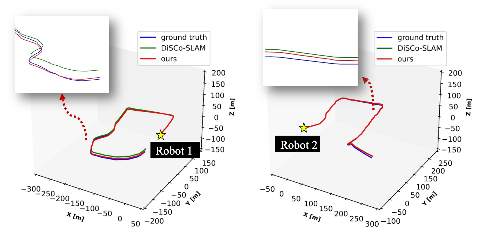
Figure 2: Quantitative localization trajectories computed by the proposed method, DiSCo-SLAM, and LIO-SAM odometry showing significant suppression of drift.
For Robot 1, the proposed method achieves a 3.62m RMSE versus 7.09m for DiSCo-SLAM and 7.01m for LIO-SAM, yielding a 48.9% reduction compared to DiSCo-SLAM. Robot 2 shows a 2.38m RMSE, a 13.4% improvement over DiSCo-SLAM and 51.4% over LIO-SAM. The mapping output aligns accurately with satellite ground-truth after trajectory fusion with the certifiable PGO solution.

Figure 3: Decentralized pipeline depicting Scan Context loop closures, P2P submap synchronization, certifiable PGO, and volumetric map fusion.
Theoretical and Practical Implications
The system demonstrates that integrating a certifiably optimal PGO backend removes the local-minima vulnerabilities inherent to local search-based decentralized SLAM, especially in challenging, weakly observable environments. The explicit verification of solution globality and the rejection of degenerate solutions establish a new robustness benchmark for large-scale multi-robot SLAM. From a theoretical perspective, the use of dual certificates and guarantees over SE(3) can serve as a foundation for further extensions, including tighter integration with heterogeneous sensors, dynamic environment robustness, and scalability to even larger fleets. Practically, this enables highly consistent volumetric mapping for real-world autonomous robots in infrastructure-constrained or GNSS-denied scenarios.
Conclusion
The proposed decentralized LiDAR-SLAM framework unifies every intra- and inter-robot geometric constraint into a certifiably globally optimal batch PGO. Empirical results show significant improvements in localization RMSE and trajectory consistency compared to state-of-the-art decentralized systems. The dual certificate-based approach eliminates local minima and non-global solutions, providing structural guarantees essential for real-world long-term deployment. Future work may include generalization to cross-modal sensor suites and operation in even more adverse environments, further extending the certifiable SLAM paradigm.