- The paper presents a novel neural encoder that estimates signed distances between convex polygonal vehicle representations and LiDAR point clouds.
- The integration with MPPI control enables real-time, perception-driven, collision-aware navigation for articulated tractor-trailer systems.
- Empirical results demonstrate high accuracy with MSE below 1×10⁻⁵ and robust navigation performance at control rates around 30Hz.
Neural Distance-Guided Path Integral Control for Tractor-Trailer Navigation
Introduction and Motivation
The problem of autonomous navigation for articulated tractor-trailer systems in dense, dynamic environments is characterized by nonlinear, high-dimensional dynamics and nontrivial geometric interactions between complex vehicle geometry and unstructured obstacles. Traditional solutions depend on precomputed geometric simplifications, map-based Euclidean Signed Distance Fields (ESDF), or computationally expensive optimization-based collision checks, all of which limit real-time applicability in agricultural environments where obstacle geometry and density continually vary.
This paper addresses these deficits by introducing a duality-inspired geometric neural encoder that predicts signed distances between articulated convex polygonal vehicle representations and raw 2D LiDAR point clouds, circumventing the need for map-based geometric reasoning. These neural distance estimates are integrated into a Model Predictive Path Integral (MPPI) control scheme, producing real-time, perception-driven, dynamically feasible, and collision-aware navigation solutions.
Geometric Neural Encoder for Map-Free Signed Distance Estimation
Accurate real-time proximity estimation between the articulated vehicle and complex obstacles is essential for responsive collision avoidance. Prior methods such as OBCA formulations[zhang2020optimization], safe-corridor trajectory planners[wei2025efficient], or ESDF updates[xu2025tracailer], are limited by inefficiency, conservatism, or the need for prior maps. The neural encoder presented here directly leverages the strong duality of the point-to-polygon distance problem, parameterizing the articulated tractor and trailer as a union of convex polygons.
The encoder is trained to map transformed obstacle points (expressed in each polygon's local frame) to dual variables, from which the exact signed distances are reconstructed. Training uses a large synthetic dataset generated by solving penalized dual optimization problems with CVXPY+ECOS for convex polygons, offering both efficient and accurate supervision.
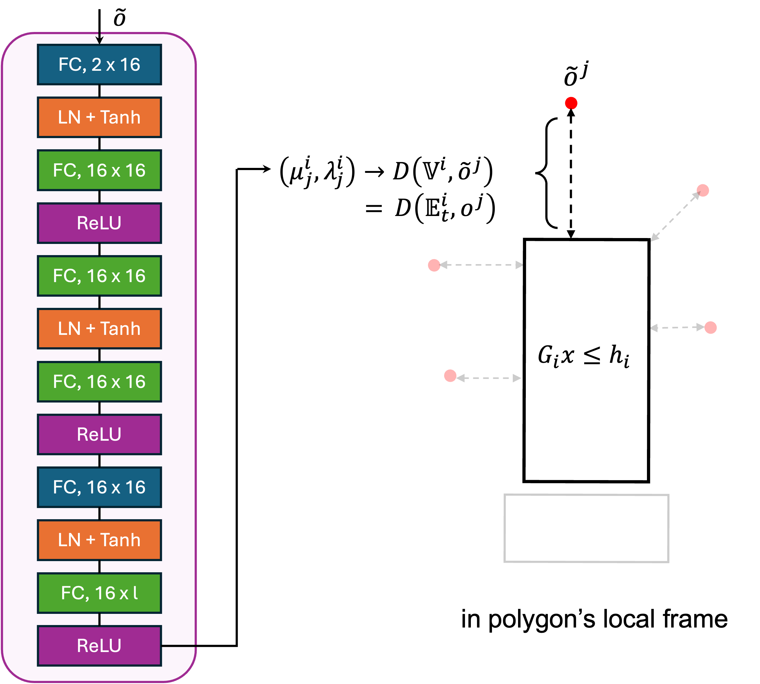
Figure 1: Architecture of the geometric neural encoder (left) and the geometric relationship between convex polygonal vehicle bodies and transformed obstacle points (right).
The architecture consists of stacked fully connected layers with tanh and ReLU nonlinearities, optimized to predict dual variables for a given polygon. Once trained, this approach yields mean squared errors in the dual variables and distances below 1×10⁻⁵ and enables high-throughput distance queries on GPU-accelerated hardware. Each polygon of the articulated body is endowed with its own encoder, resulting in a small set of reusable neural networks that generalize to any LiDAR observation.
Model Predictive Path Integral (MPPI) Control
The control framework is a fully-sampled, non-gradient, stochastic optimal controller—particularly well suited to complex kinematic constraints, nonconvex costs, and high-dimensional observations. The dynamics are discretized kinematic models for off-axle tractor-trailers, augmented to promote smoother and dynamically feasible trajectories via acceleration and steering-rate control inputs.
At each iteration, the MPPI controller samples hundreds to thousands of feasible control sequences with injected Gaussian noise, propagates resulting trajectories, and evaluates running costs based on:
- Goal state deviation,
- Control effort and smoothness,
- Articulation constraints (preventing jackknife),
- Obstacle proximity using neural distance estimates.
The signed distance barrier potential penalizes approaches to obstacles, transitioning sharply to a linear penalty upon contact. This exploits the fine-grained, accurate proximity information from the neural encoder, avoiding both excessive conservatism and the false negatives of simple collision checks.
Aggregate control updates are performed by importance-weighted averaging across sampled rollouts according to their exponential cost, ensuring both exploration of feasible space and exploitation of low-cost solutions.
Simulation studies with an articulated tractor-trailer—modeled via three convex polygons—demonstrate the pipeline's efficacy. Training of all required neural encoders over 100,000 points per polygon is completed in ∼2.2 hours on high-end hardware. The controller, configured with a 50-step horizon (0.1s/step), 1000 rollouts, and tuned weights for goal-tracking, smoothness, articulation, and collision, achieves real-time control rates (∼30Hz).
Navigation in a densely cluttered simulated field with goal achievement is shown to be robust, dynamically feasible, and collision-free:
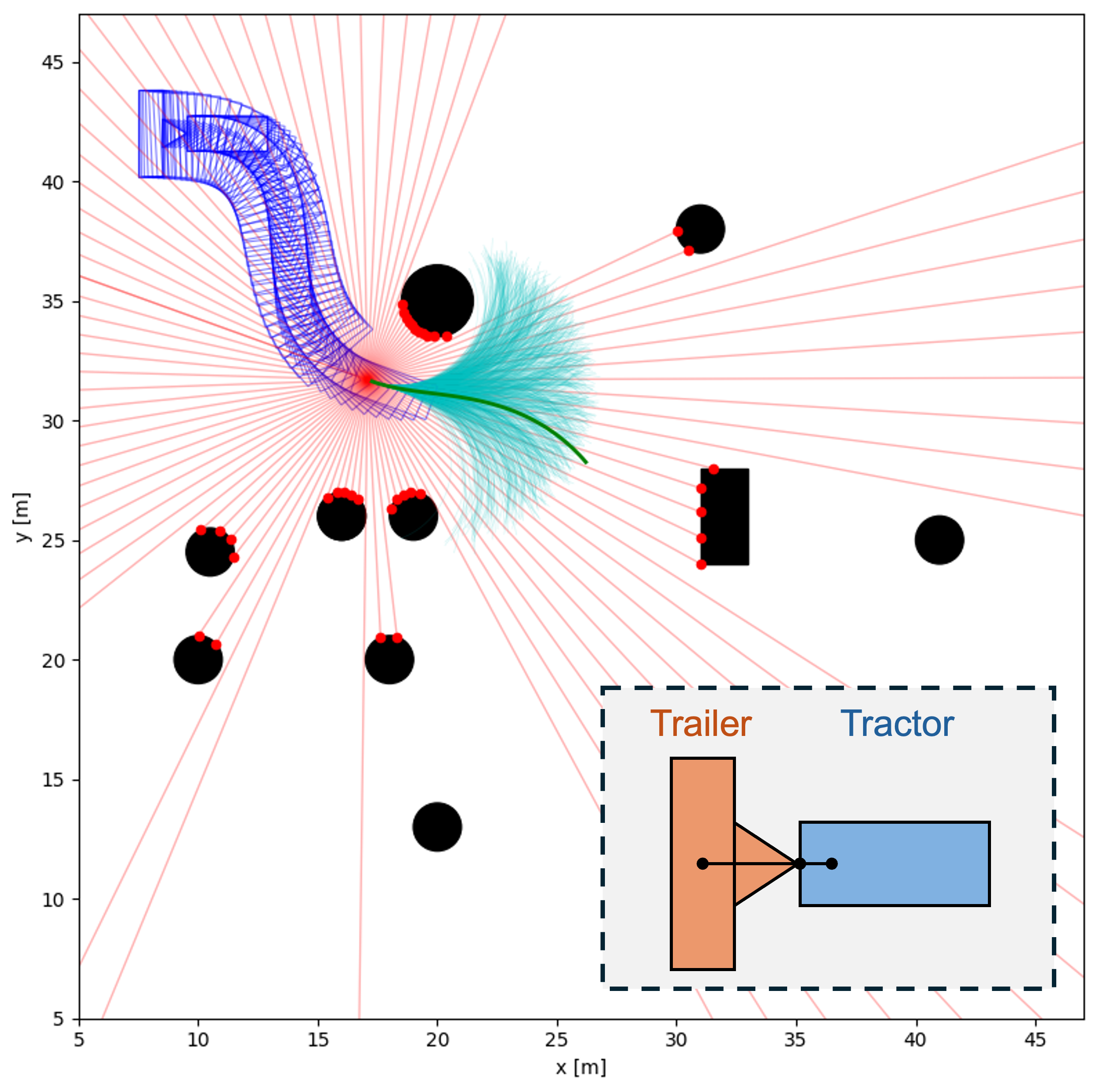
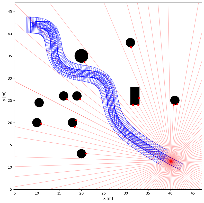
Figure 2: Top: Sampled rollouts and selected optimal trajectory during navigation. Bottom: Final vehicle configuration, collision-free at the designated goal.
The system demonstrates accurate, reactive navigation without prior maps or explicit geometric simplifications, maintaining safe clearances and dynamically feasible articulation throughout.
Theoretical and Practical Implications
The presented framework provides several notable contributions:
- Strong numerical convergence: Distance prediction MSEs on unseen test data are consistently below 1×10⁻⁵, marking a significant improvement over geometric primitives or fully optimization-based methods.
- Real-time feasibility: The use of parallelizable neural networks for distance queries combined with GPU-based MPPI enables control rates suitable for deployment on real robots.
- Perception-driven planning: By leveraging raw LiDAR without a prior map, the approach is adaptable to dynamic, cluttered, or unknown environments, making it highly relevant for agricultural robotics.
Notably, the framework's modularity extends to arbitrary polygonal bodies, with generalization limited only by the need for encoder retraining per new vehicle geometry. The MPPI paradigm is robust to high-dimensional, nonconvex costs—a perennial issue for articulated vehicle control.
Future Directions
Key avenues for further research include:
- Universal neural encoders: Generalizing the encoder across arbitrary polygonal geometries to obviate per-geometry retraining.
- Hierarchical/global planning integration: Addressing potential local minima with global planners, especially in densely constrained fields.
- Robust real-world deployment: Including full 3D perception integration, noise filtering, and adaptation to moving obstacles or dynamic scenes.
- Reverse motion and complex maneuvers: Quantitative benchmarking under challenging motion sequences and comparison with state-of-the-art planning algorithms.
Conclusion
The integration of a duality-influenced geometric neural encoder with sampling-based MPPI control yields a perception-driven, real-time navigation pipeline for articulated tractor-trailer systems operating in complex, unstructured environments. The framework demonstrates high accuracy in signed distance estimation, robust collision avoidance, and practical feasibility for agricultural robotics and beyond. Adoption of universal geometric encoding and robust planner integration is posed as a logical extension to address increased mission complexity and dynamic uncertainty.