- The paper introduces a flow matching model that achieves 4x super-resolution for Sentinel-2 imagery with high pixel fidelity using a deterministic ODE-based method.
- The methodology leverages a large, paired Sentinel-2/NAIP dataset and uses L1 loss to stabilize training and control the perception-distortion trade-off.
- Empirical results show that an Euler solver at T=1 outperforms diffusion and GAN methods in PSNR and SSIM while maintaining analytical accuracy for land cover segmentation.
Flow Matching for Sentinel-2 Super-Resolution: Technical Overview and Implications
Introduction and Motivation
The proliferation of deep learning-based super-resolution (SR) models for satellite imagery has largely been dominated by GANs and, more recently, diffusion models. However, the inherent instability and perception-distortion trade-offs of GAN frameworks, combined with the high inference costs of diffusion approaches, pose practical limitations for producing reliable, high-resolution synthetic satellite imagery optimized for downstream analytical tasks. This paper introduces and systematically evaluates a flow matching approach for 4× SR of 10-meter Sentinel-2 imagery, leveraging NAIP aerial imagery as cross-calibrated ground truth, and demonstrates its application to generate synthetic 2.5-meter products across CONUS with implications for geospatial analytical workflows.
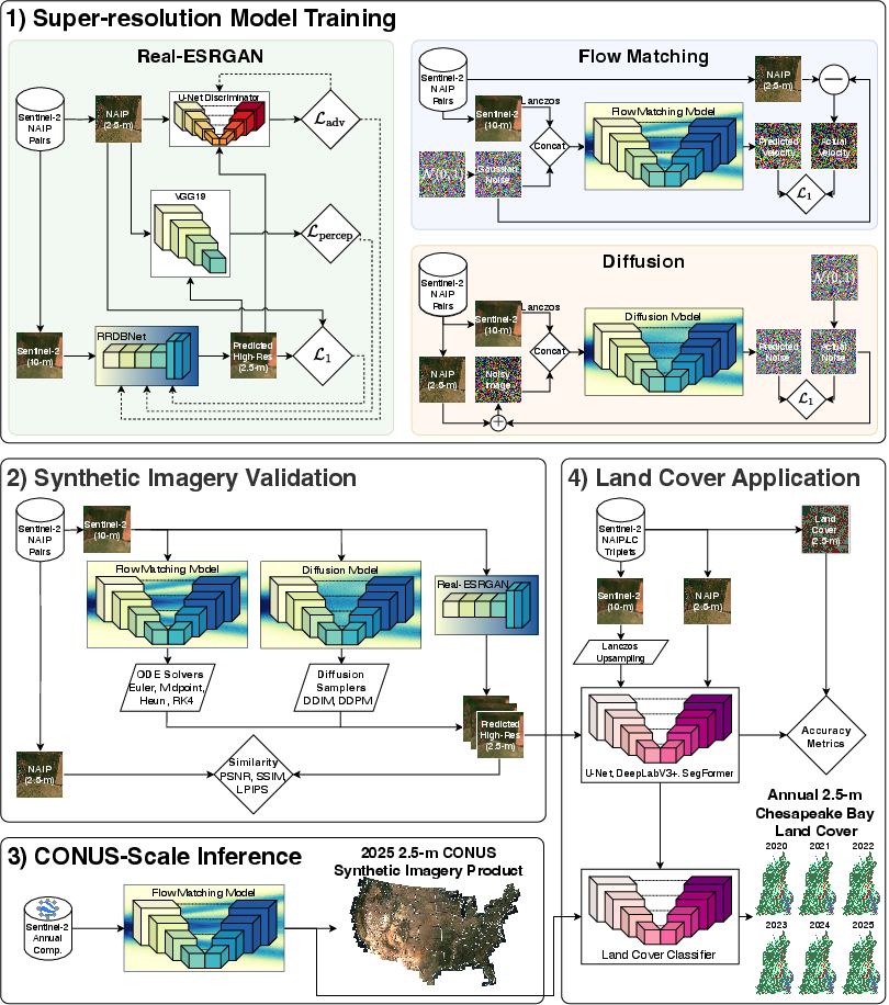
Figure 1: A high-level overview of the methodology used in this study.
Data Curation and Processing
A CONUS-scale paired dataset of 120,851 Sentinel-2 and date-aligned, cross-calibrated NAIP images was constructed, ensuring strict spatial and temporal alignment to maximize the reliability of supervised SR model training. Calibration of NAIP to Sentinel-2 surface reflectance was achieved via per-band OLS regression, ensuring comparability across sensor modalities and enabling the creation of a reference standard for evaluating both pixel-wise and perceptual fidelity of synthetic outputs.
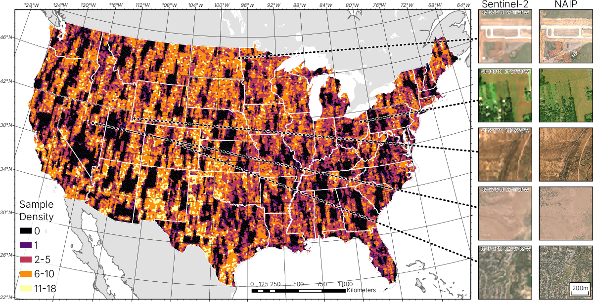
Figure 2: Spatial distribution of Sentinel-2 and NAIP image pairs used for training/evaluation (left) and representative imagery pairs (right).
Additionally, Sentinel-2/NAIP/land cover label triplet datasets were created for the Chesapeake Bay watershed region to rigorously evaluate the impact of SR quality on downstream semantic segmentation/classification.
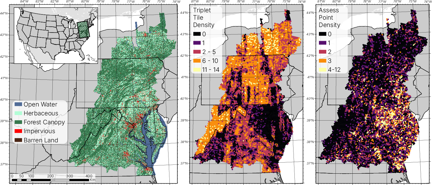
Figure 3: Reclassified CBLC classes (left), sample triplet locations (middle), and accuracy assessment point locations (right).
The core innovation is the adaptation of flow matching [Lipman et al., (Lipman et al., 2022)] to the spatial super-resolution domain. The model learns deterministic continuous flows between Gaussian noise and empirical image data distributions, parameterized via a U-Net conditioned on upsampled low-resolution Sentinel-2 inputs. The network is trained to match the velocity vector fields of interpolated samples between noise and data, allowing for efficient ODE-based inference with post-hoc selection of solvers and step count T.
The methodology ensures stable training by utilizing ℓ1 loss and circumvents the adversarial or perceptual biases present in GAN-based approaches. Crucially, the deterministic ODE-solving framework allows for explicit control of the perception-distortion frontier by adjusting T and solver type at inference time.
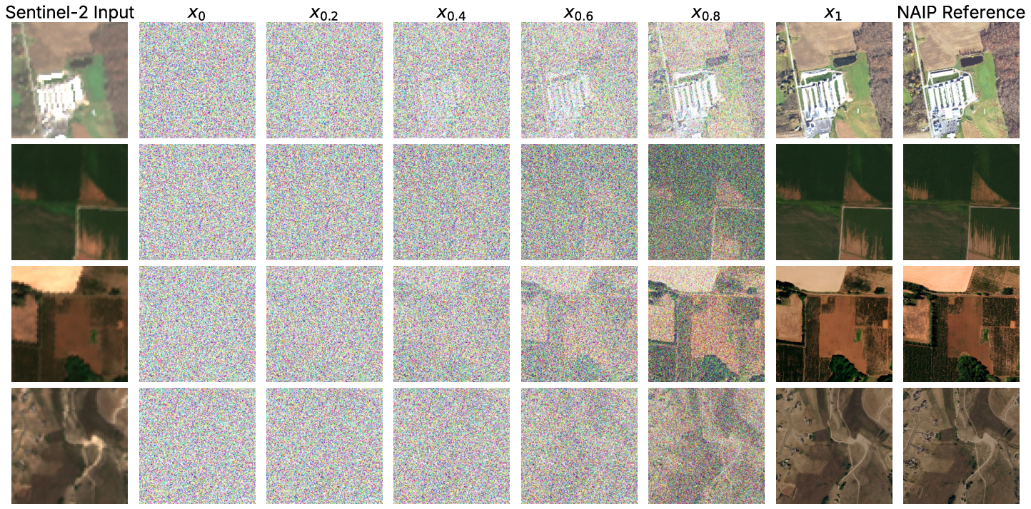
Figure 4: Flow matching SR via Euler solver: sample refinement from Gaussian noise x0 to SR output x1 in T steps.
Empirical Benchmarking Against Diffusion and GAN Methods
Performance was benchmarked against both DDPM/DDIM diffusion models and Real-ESRGAN, using identical U-Net backbones and identical training data splits to ensure experimental parity. Evaluation utilized PSNR and LPIPS as primary metrics for pixel-wise and perceptual quality, respectively, across a range of sampling step counts and ODE/diffusion solvers.
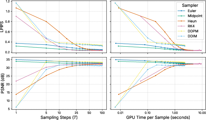
Figure 5: PSNR and LPIPS of flow matching/diffusion-based SR models and solvers across T.
The first-order Euler solver using T=1 exhibited the highest PSNR (34.95 dB) and SSIM (0.8316), outperforming both the best diffusion setting (33.31 dB @ T=100) and Real-ESRGAN (33.29 dB), while also achieving competitive or superior regression agreement on band-wise surface reflectance values.
Qualitatively, increasing T0 in the flow-matching ODE (particularly with Midpoint or RK4 solvers) shifted output images along the perception-distortion continuum—yielding more visually plausible detail but decreasing spectral (and analytical) fidelity.
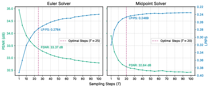
Figure 6: Euler vs. Midpoint solver trade-offs: higher T1 improves LPIPS but degrades PSNR.
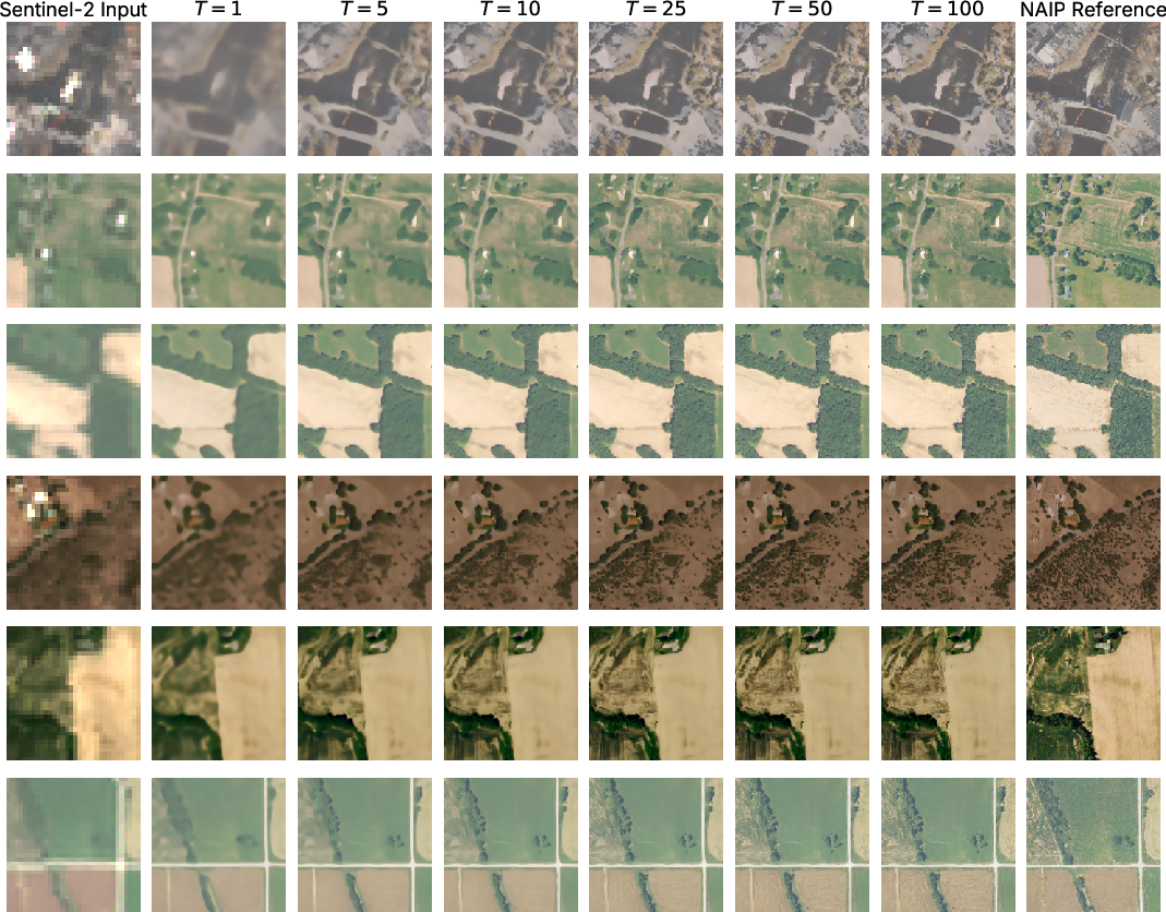
Figure 7: Visual appearance of SR outputs for increasing T2 in Euler-based flow matching; excessive steps induce hallucinated details.
Real-ESRGAN generated lower LPIPS (0.1937) but introduced domain-invalid artifacts and spectral bias, especially in urban scenes—likely a consequence of both the adversarial and ImageNet-based perceptual terms not transferring to the geospatial context.
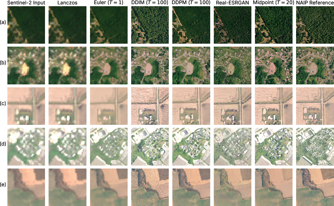
Figure 8: Comparison of SR outputs from various models, showcasing flow matching's qualitative superiority in urban structure preservation.
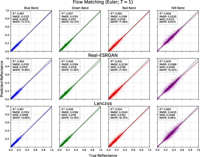
Figure 9: Per-band regression for Euler (T3), Real-ESRGAN, and Lanczos resampling vs. true NAIP reflectance.
The flow matching approach—especially with Euler/T4—showed the best overall pixel-level fidelity and generalization across scenes, including enhanced demarcation of urban and agricultural features in large-scale, temporally consistent synthetic SR products.
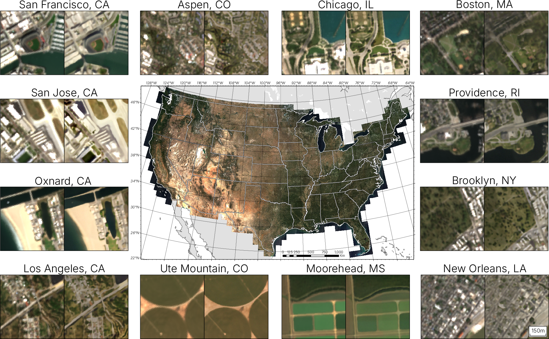
Figure 10: CONUS-scale synthetic 2.5 m imagery for 2025 generated using flow matching SR.
Downstream Land Cover Classification Impact
A critical practical evaluation was performed by training U-Net, DeepLabV3+, and SegFormer models for five-class land cover segmentation using variously upsampled Sentinel-2 data (Lanczos, Real-ESRGAN, and flow matching SR), as well as gold-standard NAIP.
The Euler solver with T5 provided consistent improvements over Lanczos and Real-ESRGAN specifically in class-wise F1 for impervious (urban) surfaces—up to 2 % in F1—while overall macro-averaged improvement was modest (typically 0.16 % average F1 gain).
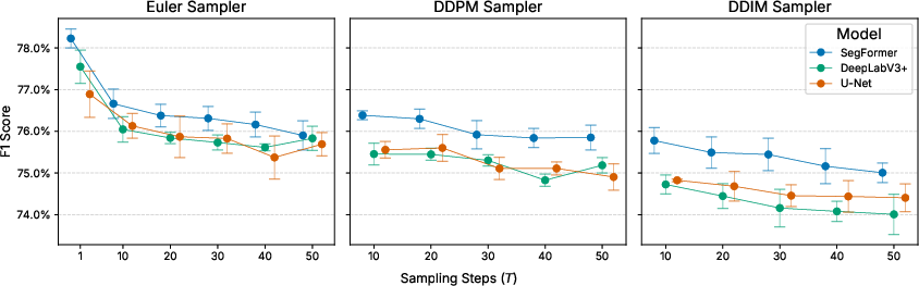
Figure 11: F1 score for land cover classification vs. T6; increasing T7 impairs analytical performance, despite improved perceptual similarity.
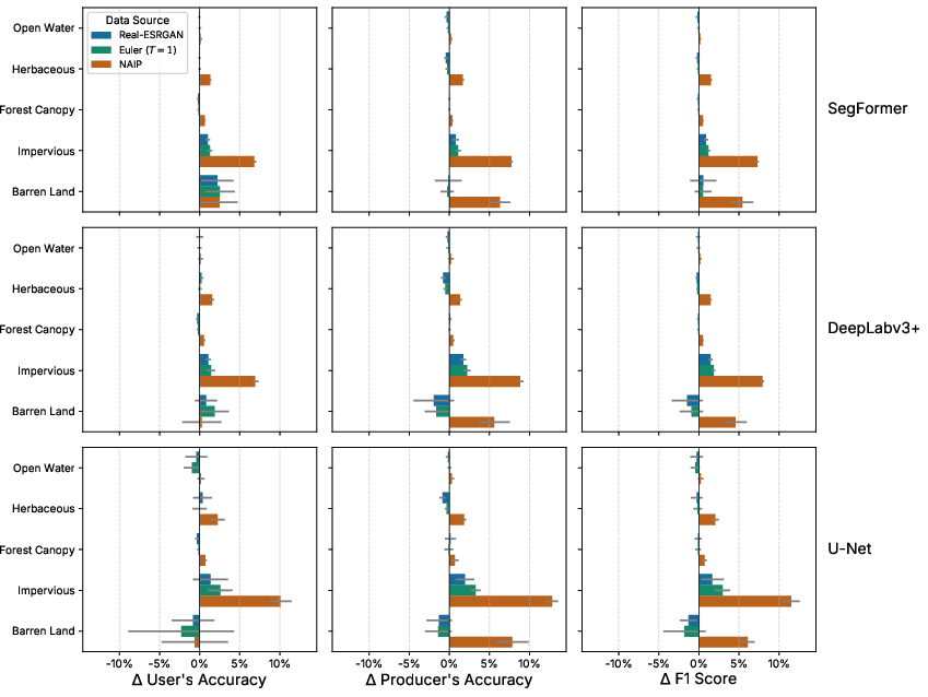
Figure 12: Per-class delta in accuracy for Real-ESRGAN, flow matching (Euler T8), and NAIP compared to Lanczos baseline.
Notably, increasing T9 (and hence improving LPIPS) consistently degraded segmentation accuracy—indicating that hallucinated detail from "perceptual" super-resolution is detrimental for analytical remote sensing tasks that depend on spectral integrity. This provides empirical support for prioritizing distortion-minimizing inference for geospatial use cases.
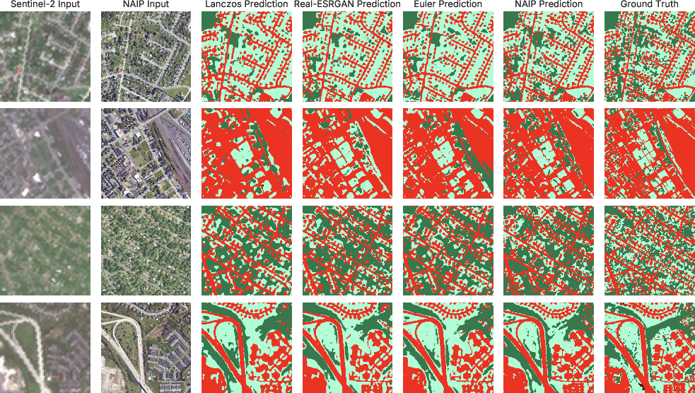
Figure 13: Urban LULC predictions for SegFormer at 2.5 m under different upsampling methods (clear improvement with flow matching SR).
The best-performing workflow—SegFormer trained with Euler (flow matching, ℓ10) synthetic SR images—achieved overall accuracy of 89.11 % and macro F1 74.4 % in the Chesapeake Bay dataset, with the highest reliability for water and forest classes and improvements in impervious surface delineation.
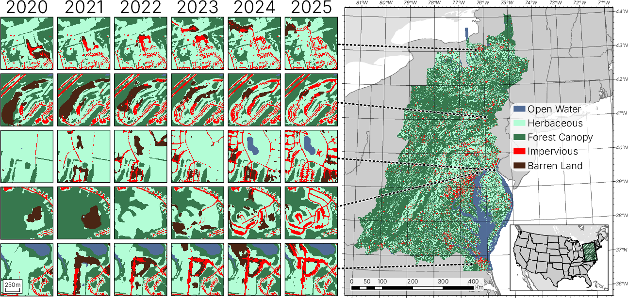
Figure 14: Examples of high-frequency land cover transitions detected in annual Chesapeake Bay 2.5 m product (2020–2025).
Theoretical and Practical Implications
Bold claim: The empirical findings demonstrate that flow matching models, when paired with deterministic, single-step ODE solvers, can achieve both superior pixel-wise SR accuracy and practical computational efficiency compared to contemporary diffusion and GAN-based methods. The capacity for real-time inference and tractable control of the perception-distortion trade-off at deployment is a decisive advantage in operational settings.
The study further highlights that perceptual metrics and GAN/LPIPS-driven pipelines optimized for photorealism are poorly aligned with geospatial analytical requirements and may, in fact, degrade downstream classification and biophysical retrieval tasks.
Of critical importance is the domain transferability and scalability demonstrated by generating a 1.58 trillion pixel synthetic product at 2.5 m across CONUS and temporally explicit land cover maps for the Chesapeake Bay watershed, indicating the workflow's practical readiness for large-scale environmental monitoring, land use planning, and urban analytics.
Prospects and Future Directions
From a methodological standpoint, further improvements may be realized by introducing semantic guidance or auxiliary cross-sensor/contextual information into the flow-matching conditioning pipeline (see also semantic-guided flow matching [Gong et al., TGRS 2025]). Adaptive ODE solvers and better spectral/perceptual evaluation metrics for remote sensing (rather than transfer from natural image domains) are warranted.
Given the convergence of continuous normalizing flows and efficient ODE-based sampling, future SR methods are likely to focus on the deterministic, analysis-friendly regime, with an emphasis on transparency, control, and spectral fidelity rather than adversarial photorealism.
Conclusion
This paper constitutes a rigorous empirical and methodological advancement in satellite imagery SR, establishing flow matching as a highly effective and computationally efficient alternative to both GAN and diffusion-based approaches for geospatial applications. The capacity to explicitly manage the perception-distortion frontier post training and the strong alignment with downstream analytical performance render flow matching a highly promising direction for scalable, trustworthy remote sensing super-resolution (2605.00367).

