- The paper presents a novel benchmark and an end-to-end HaLoBuild-Net framework tailored for extracting building footprints under hazy and low-light conditions.
- It leverages dual-domain spatial-frequency fusion, integrating global multi-scale guidance and mutual-guided calibration to counteract image degradations.
- Empirical results demonstrate significant gains in IoU and F1 scores over traditional cascaded methods on both adverse-condition and standard remote sensing datasets.
Building Extraction from Remote Sensing Imagery under Hazy and Low-light Conditions: Benchmark and Baseline
Introduction
The paper "Building Extraction from Remote Sensing Imagery under Hazy and Low-light Conditions: Benchmark and Baseline" (2604.15088) addresses a significant gap in optical remote sensing: the robust extraction of building footprints from imagery subject to haze and low-light degradations. While much progress has been made in high-resolution building extraction under ideal conditions, real-world constraints such as atmosphere-induced scattering and nocturnal imaging significantly degrade visual cues and drastically change the input distribution. The proposed research is two-fold: (i) the establishment of the HaLoBuilding benchmark, the first large-scale dataset focused on hazy and low-light scenarios for building segmentation; and (ii) the introduction of HaLoBuild-Net, an end-to-end, dual-domain building extraction framework that circumvents explicit image enhancement by integrating spatial and frequency-based feature modulation.
HaLoBuilding: Dataset Construction and Analysis
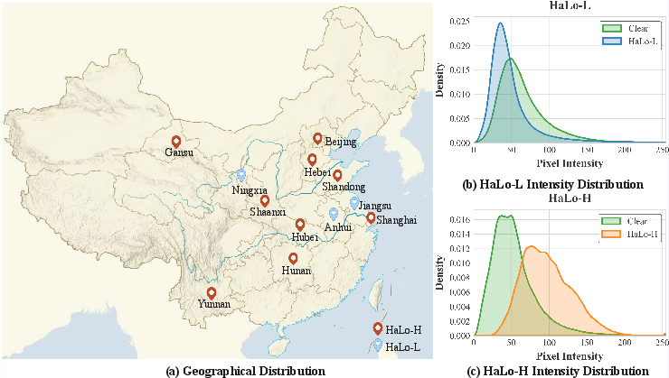
Prior datasets in building extraction, including WHU Building, INRIA, Massachusetts, and LoveDA, primarily encompass clear-weather imagery, with negligible support for adverse conditions. The HaLoBuilding benchmark fills this deficit with 4386 annotated images drawn from China's diverse urban, rural, and coastal regions, captured by GF2-PMS and GF7-DLC satellites between 2021–2023.
A novel annotation pipeline ensures high-fidelity semantic labels even under severe degradation:
Kernel Density Estimation exposes strong intensity distribution shifts: haze increases background luminance and attenuates contrast, while low-light skews data towards darker intensities, introducing severe information loss. HaLoBuilding's two subsets, HaLo-H (haze) and HaLo-L (low-light), comprehensively sample these degradations, making it distinctly harder than existing collections.
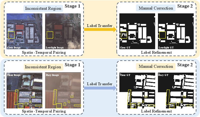
Figure 2: Annotation workflow, illustrating precise alignment and rigorous manual label correction for degraded views.
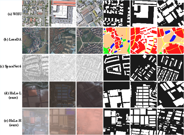
Figure 3: Sample comparisons demonstrating challenges: clear scenes (WHU, LoveDA), SAR distortions (SpaceNet 6), low-light (HaLo-L), and haze (HaLo-H).
HaLoBuild-Net: Architecture and Methodology
Most prior pipelines utilize cascaded enhancement-segmentation paradigms, amplifying computational redundancy and propagating artifacts (see conceptual distinction in Figure 4). HaLoBuild-Net avoids these traps via direct feature-level optimization tailored for adverse visibility, leveraging three principal modules:
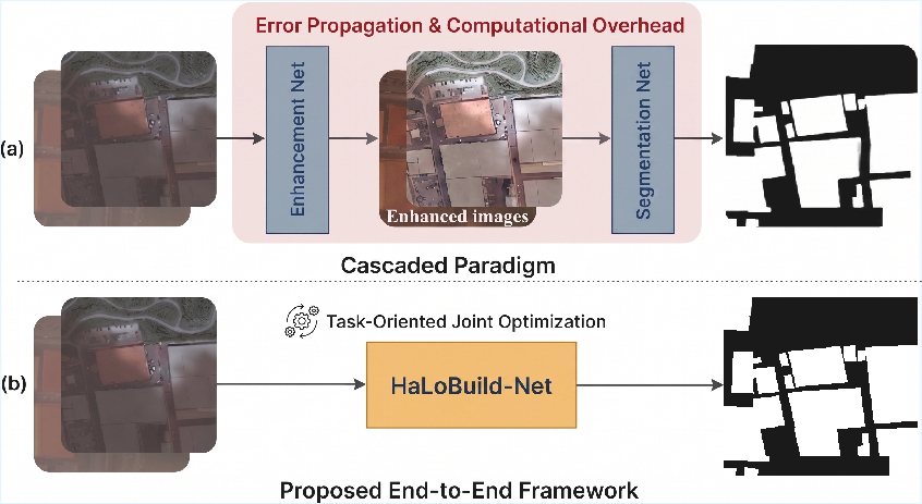
Figure 4: Comparison between cascaded (artifact-prone) versus end-to-end architectures exemplified by HaLoBuild-Net.
- LWGANet-L2 Backbone: A lightweight group attention encoder, tuned for scale variance and efficient remote sensing representation.
- Mutual-Guided Fusion Module (MGFM): Bidirectional semantic-spatial calibration. Deep features denoise and structure shallow features, while shallow features sharpen blurred semantic boundaries, achieving effective decoupling of true building characteristics from meteorological noise.
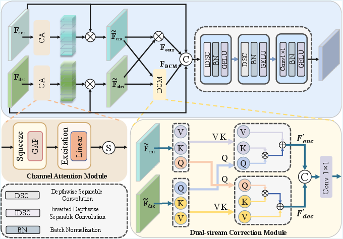
Figure 5: MGFM structure, enabling noise suppression and geometry restoration via dual guidance.
- Global Multi-scale Guidance Module (GMGM): Aggregates multi-scale shallow features into rich global semantic priors, anchoring topological context and compensating for missing local cues in severely degraded inputs.
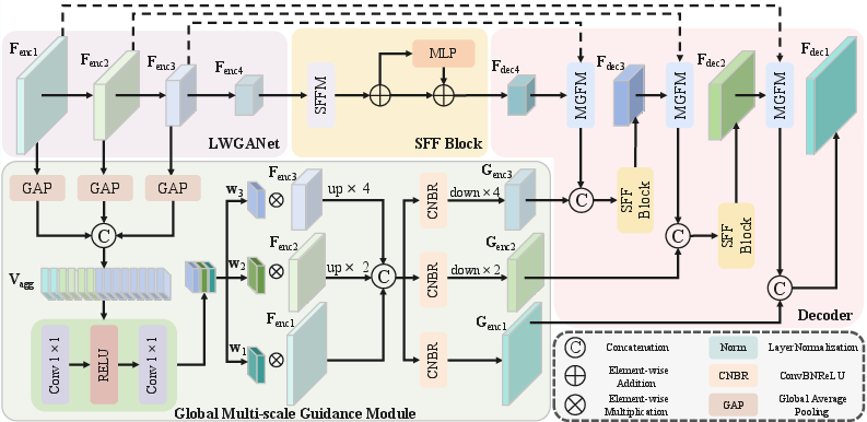
Figure 6: HaLoBuild-Net framework schematic, showing interplay among LWGANet-L2 encoder, GMGM, MGFM, and SFFM blocks.
- Spatial-Frequency Focus Module (SFFM): Fuses spatial attention (with large receptive field) and frequency-aware channel reweighting. Low-frequency spectral anchors provide robust global structure priors, countering degradation-induced unreliability in high-frequency representations.
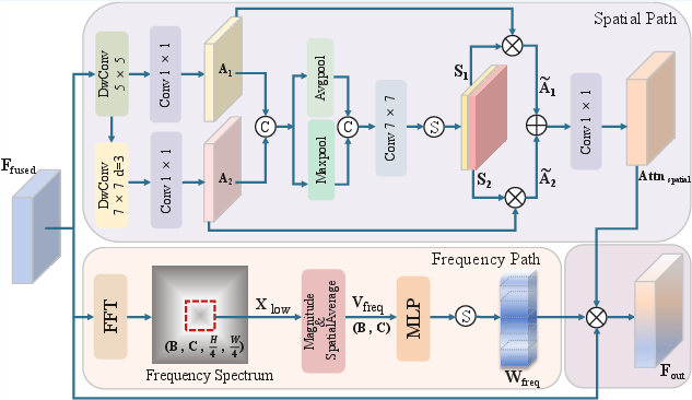
Figure 7: SFFM schematic, illustrating collaborative spatial and frequency path optimization.
Experimental Results and Analysis
HaLoBuild-Net demonstrates marked performance gains over state-of-the-art baselines and cascaded paradigms on both HaLo-L (IoU: 68.90%, F1: 81.59%) and HaLo-H (IoU: 70.88%, F1: 82.96%). Direct, end-to-end inference outperforms pre-processing via dehazing (DEA-Net) or low-light enhancement (GSAD), which often introduce artifacts, blur edges, or hallucinate building-like structures, especially in low-light.
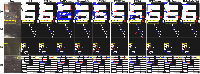
Figure 8: Visual results on HaLo-L exemplifying robust global reasoning, edge separation, and small-object sensitivity under extreme low-light conditions.
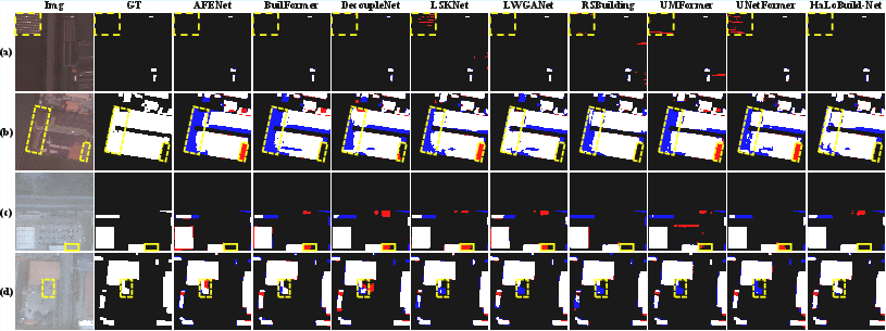
Figure 9: Visualization on HaLo-H, demonstrating effective separation of buildings from confusable features (e.g., greenhouses) under dense haze.
Generalization to Standard Benchmarks
Despite being designed for adverse-weather conditions, HaLoBuild-Net matches or surpasses prior methods on conventional benchmarks:
- WHU: IoU 91.88%, F1 95.77%
- INRIA: IoU 82.53%, F1 90.43%
- LoveDA: mIoU 54.04% (buildings IoU 60.25%)
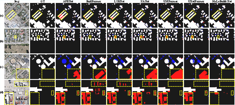
Figure 10: Comparison on WHU, showing sharp boundary preservation and resistance to homomorphic interference.
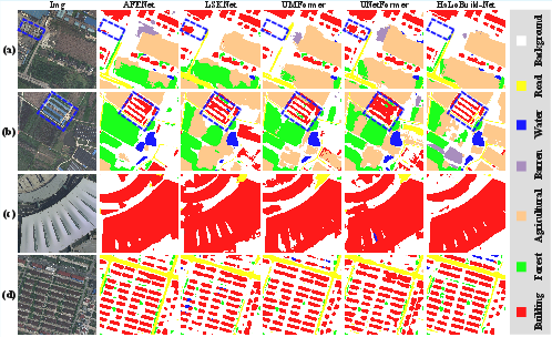
Figure 11: Visualizations on LoveDA, evidencing scene complexity handling and dense small-target discrimination.
Ablation and Component Study
- MGFM contributes the largest single boost; dual semantic-spatial calibration is notably decisive for handling boundary loss and noise.
- GMGM delivers robust gains, especially in retaining global structure under adverse conditions.
- SFFM is superior when both spatial and frequency branches operate jointly, as shown by additional ablation; optimal performance is achieved at a H/4×W/4 spectral crop ratio, balancing global anchor retention and artifact suppression.
Implications and Future Perspectives
The HaLoBuilding benchmark establishes a new standard for adverse-condition semantic segmentation in optical remote sensing, with its design offering reproducibility and high annotation fidelity. HaLoBuild-Net validates the hypothesis that end-to-end, dual-domain collaborative optimization is superior to cascaded or image-enhancement-based paradigms when facing weather-induced domain shifts. Practically, this enables far more reliable building footprint extraction in environments previously considered infeasible (e.g., night-time urban monitoring, post-hazard response in low visibility).
Theoretically, the success of coupling frequency-domain priors and multi-scale spatial aggregation suggests general strategies for vision tasks in highly degraded scenarios; the demonstrated module synergy points to avenues in integrating semantic and geometric reasoning loops in future architectures. Open challenges remain in scaling such models to real-time operation and expanding to richer, multi-class segmentation targets across additional weather modalities (e.g., rain, snow, sandstorms).
Conclusion
The paper introduces HaLoBuilding, the first large-scale, geographically diverse optical benchmark for building extraction under haze and low-light conditions, along with HaLoBuild-Net, an end-to-end dual-domain segmentation framework. Empirical results establish consistent, strong gains over contemporary baselines both in-target and out-of-domain, underpinning the architectural value of spatial-frequency fusion and global guidance under severe signal degradation. The dataset and codebase are expected to drive subsequent advances in robust remote sensing perception, with future work aimed at even broader all-weather, multimodal generalization.