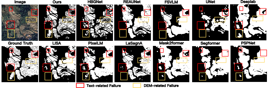
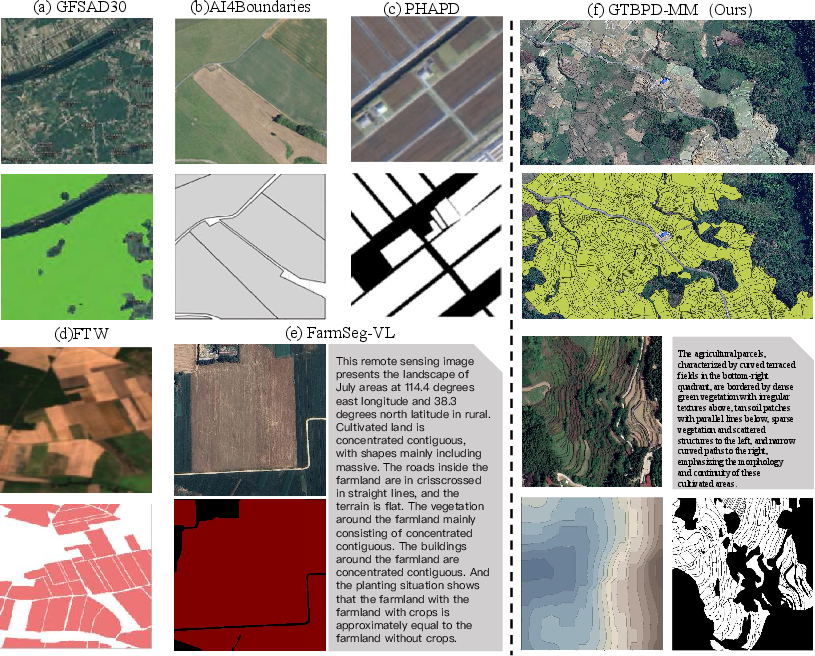
- The paper introduces a novel multimodal benchmark that integrates high-resolution imagery, DEM, and text for terraced parcel extraction.
- It details the ETTerra architecture featuring cross-modal semantic enhancement and elevation-guided boundary reinforcement, yielding superior segmentation metrics (mIoU = 68.73, ODS = 49.52).
- The dataset spans 900 km² across 25 countries, addressing semantic ambiguity and boundary precision in complex, mountainous agricultural terrains.
Introduction
Automated extraction of agricultural parcels remains a central topic in remote sensing for agricultural monitoring, underpinning applications such as precision agriculture, ecological assessment, and land management. Existing benchmarks are dominated by regular, flat farmland terrains and focus predominantly on single-modality (visual-only) data, limiting their applicability in the more structurally complex, mountainous terraced landscapes prevalent across large global regions. "GTPBD-MM: A Global Terraced Parcel and Boundary Dataset with Multi-Modality" (2604.12315) introduces the first large-scale, multimodal benchmark tailored to these challenges, integrating high-resolution optical imagery, Digital Elevation Models (DEM), and structured text descriptions for unified parcel delineation and boundary extraction.
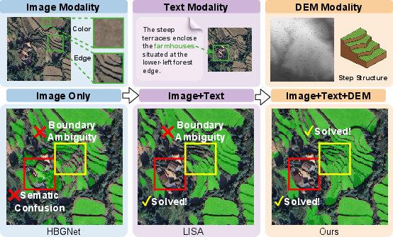
Figure 1: Multi-modality (image, text, DEM) addresses semantic confusion and boundary ambiguity intrinsic to complex terraced parcel extraction scenes.
GTPBD-MM Dataset: Coverage, Composition, and Diversity
GTPBD-MM is designed to systematically address the key limitations in current publicly available parcel delineation datasets:
- Modalities: Each sample in GTPBD-MM includes a spatially aligned triplet of high-resolution RGB imagery, DEM grids, and task-oriented textual descriptions, with hierarchical parcel, mask, and boundary annotations. This triplet reflects the joint appearance, geometric, and semantic context that governs terraced landscape structure.
- Global Coverage: The dataset spans over 900 km² of mountainous terraced regions in 25 countries, encompassing variants in elevation, geomorphology, and agrarian practices. The sampling design provides both national and international coverage, with focused expansion from core Chinese regions to SE Asia and Africa.
- Annotation Granularity: Parcel and boundary annotations support multi-task evaluation (pixel-level, edge-level, and object-level metrics). The text descriptions encode key scene priors such as terrace density, pattern irregularity, and neighboring land-cover, serving as a semantic lens to ameliorate visual ambiguity.
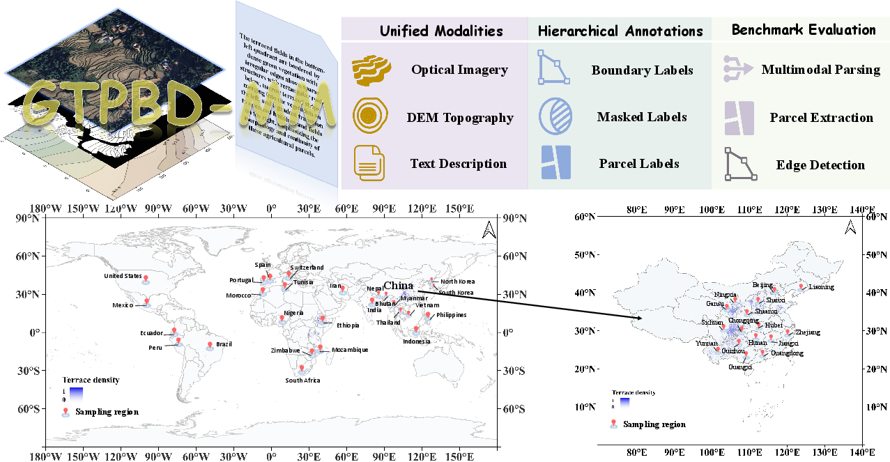
Figure 2: GTPBD-MM’s unified multi-modal design and extensive global spatial coverage (bottom), with a detailed annotation hierarchy (top).
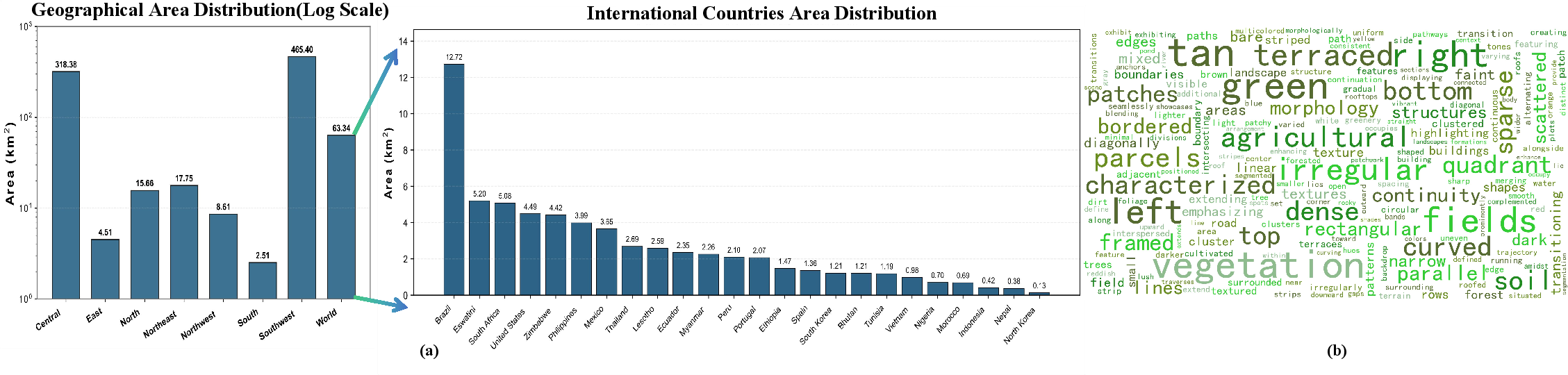
Figure 3: GTPBD-MM’s area distribution across regions/countries (left) and word frequency analysis for text modality (right), underscoring the dataset's geographic and lexical diversity.
To exploit the synergistic potential of visual, semantic, and geometric modalities, the authors introduce ETTerra: a two-branch multimodal segmentation baseline that decouples the inherent tasks of semantic discrimination and structural boundary recovery.
Cross-Modal Semantic Enhancement
A cross-attention mechanism aligns CLIP-extracted visual (Fv) and text (Ft) features, leveraging text-driven priors for disambiguating visually similar background and non-parcel classes—a primary cause of semantic confusion in mountainous, anthropogenically modified terrains.
Elevation-Guided Boundary Reinforcement
Terrain morphology—commonly the origin of parcel boundaries in terraced systems—is injected via DEM encoding. This branch learns affine modulation of RGB features with terrain gradients, reinforcing boundary delineations where elevation discontinuities coincide with actual terrace steps, mitigating under-segmentation and merging errors.
Joint Decoding
A mask decoder simultaneously incorporates text-conditioned prompts and terrain-modulated features, delivering output masks with improved semantic coherence and geometric fidelity.
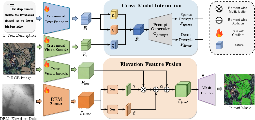
Figure 4: ETTerra’s pipeline: cross-modal interaction for semantic enhancement (left) and spatial DEM integration for terrain-feature fusion (right).
Experimental Analysis and Benchmarking
The efficacy of GTPBD-MM and ETTerra is validated across three input regimes: Image-only, Image+Text, and Image+Text+DEM, with comparison to strong segmentation and reasoning baselines (U-Net, PSPNet, REAUNet, HBGNet, LISA, PixelLM, FSVLM, among others).
Key Results:
Diagnostic Visualizations:
- Edge-level evaluations (Fig. 6) show ETTerra distinctly reduces false positive and negative edges relative to HBGNet and LISA.
- Object-level error maps (Fig. 7) indicate ETTerra yields lower under-segmentation penalties, maintaining parcel separation in topologically intricate scenes.
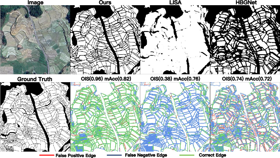
Figure 6: Edge-wise visualization demonstrates ETTerra’s reduction in segmentation error types, with robust OIS and mAcc.
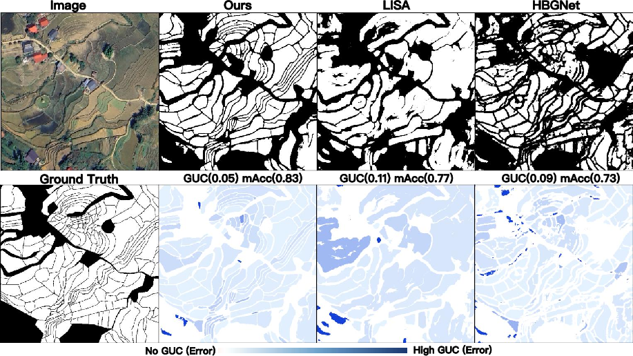
Figure 7: GUC-based analysis confirms ETTerra’s superior performance in limiting under-segmentation, especially for complex, narrow terraces.
Comparative Perspective and Broader Implications
GTPBD-MM stands out from prior datasets such as GFSAD30, FTW, or FarmSeg-VL by its focus on highly irregular, elevation-driven landscapes and by supporting coordinated image-text-DEM benchmarking. Its global, multimodal infrastructure offers a reproducible reference for robust model validation and cross-region generalization, critical as remote sensing analysis shifts towards real-world, high-heterogeneity terrains.
Theoretical Implications:
- The experimental framework demonstrates that unified multi-modal alignment is necessary for both semantic and geometric reasoning tasks in complex geospatial vision, confirming that terrain priors cannot be replaced by pure appearance or language features in certain scene classes.
Practical Implications:
- Models evaluated on GTPBD-MM are expected to show increased reliability and transferability in mountainous or developed regions globally—a significant advance for ecological and precision agriculture workflows in real-world scenarios.
Future AI Challenges:
Conclusion
GTPBD-MM establishes a rigorous benchmark for multimodal terraced parcel extraction, supporting the systematic evaluation of collaborative appearance-semantic-geometry modeling. The ETTerra baseline demonstrates that textual semantics and terrain geometry are synergistic and indispensable for robust, consistent extraction in complex agricultural regions. GTPBD-MM provides both a practical and scientific foundation for next-generation multimodal remote sensing methods and sets the standard for benchmarking in heterogeneous, non-ideal agricultural landscapes.
(2604.12315)