- The paper demonstrates that integrating Bayesian estimation with OFDM sensing reduces the minimum detectable rain rate from 4.3 mm/h to 0.95 mm/h through prior, temporal, and spatial fusion.
- It derives estimation bounds using CRB and BCRB, revealing that adaptive pilot allocation saves spectral resources while maintaining robust communication performance.
- Validation using extensive radar and gauge data confirms the model’s fidelity, achieving RMSE scaling down to 0.07 mm/h across 215 links.
Bayesian Rain Rate Estimation and Adaptive Pilot Allocation for LEO Satellite ISAC
Introduction and System Overview
The paper "Rain Rate Estimation Bounds and Weather-Adaptive Pilot Allocation for LEO Satellite ISAC" (2604.10830) rigorously formulates the estimation-theoretic limits of rain sensing over Ku-band LEO satellite downlinks using OFDM signals. Signal attenuation due to rain, characterized by the ITU-R P.838 power law, encodes precipitation information along Earth-space slant paths. Leveraging broadband satellite infrastructure for environmental monitoring is particularly impactful in regions with sparse ground radar coverage.
The paper develops a comprehensive framework integrating sensing and communication within ISAC, quantifying rain rate estimation bounds and designing adaptive pilot allocation strategies. The pipeline observes attenuation, applies CUSUM for rain detection, evaluates the Bayesian Cramér–Rao Bound (BCRB), and adapts pilot allocation accordingly.
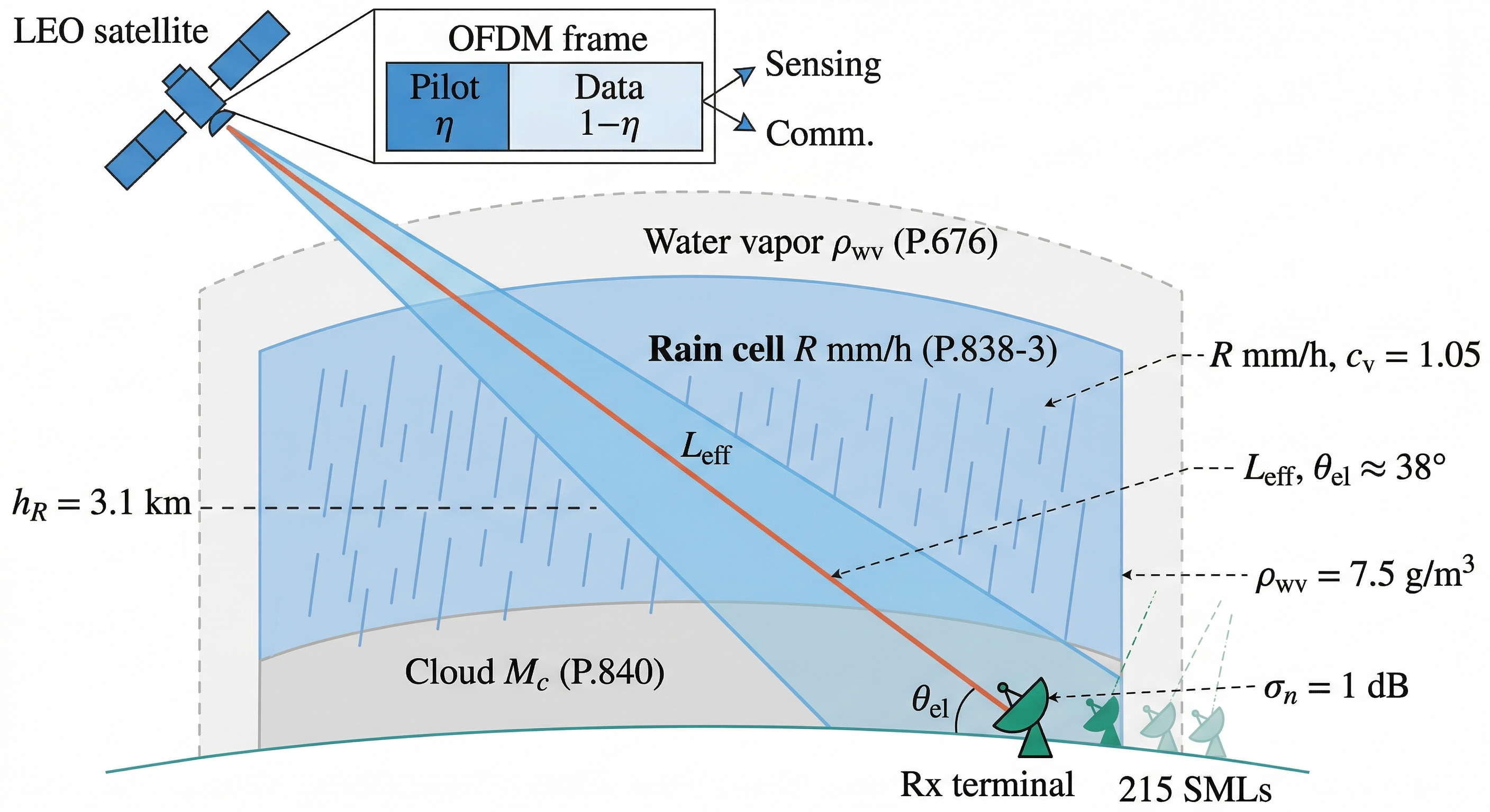
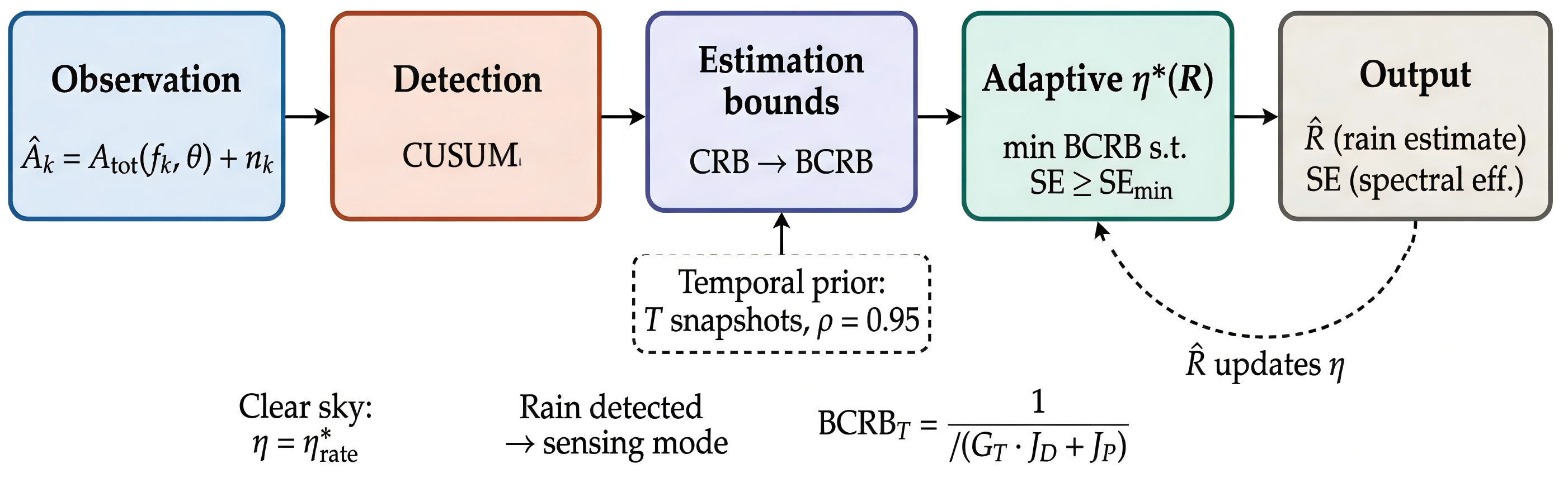
Figure 1: System overview. (a) LEO satellite Ku-band OFDM downlink attenuation by rain per P.838. (b) Pipeline: attenuation observation, CUSUM detection, BCRB evaluation, pilot fraction adaptation.
Rain estimation is analyzed through Fisher information and CRB. Using corrected P.838-3 coefficients (kˉ=0.022,αˉ=1.19), the single-link CRB at 38∘ elevation yields a minimum detectable rain rate Rmin≈4.3 mm/h. Wideband fusion (K=5 subcarriers) and additional Ka-band channels further reduce estimation error.
Identifiability is addressed via joint parameter estimation. Atmospheric nuisance parameters (water vapor, cloud mass, gas) induce severe ill-conditioning in the Fisher matrix at Ku-band, degrading the CRB by up to five orders of magnitude when jointly estimated. External side-information (NWP models, satellite cloud products) is essential to constrain nuisance variables and attain operational feasibility; the (R,G) regime is well-conditioned with only a 14.2% CRB penalty.
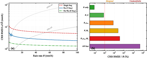
Figure 2: CRB RMSE versus rain rate for three frequency configurations and side-information hierarchy illustrating identifiability boundaries.
Bayesian CRB: Prior and Temporal Exploitation
Rain rates follow a log-normal distribution (cv=1.05 from >186,000 samples). Incorporating a prior, the BCRB tightens the estimation bound substantially—reducing Rmin from $4.3$ mm/h (CRB) to $1.1$ mm/h (BCRB, 38∘0). Exploiting temporal autocorrelation (Gauss–Markov with 38∘1) over a 38∘2-min window further reduces the bound to 38∘3 mm/h, and multi-link fusion across 38∘4 links lowers RMSE to 38∘5 mm/h at 38∘6 mm/h.
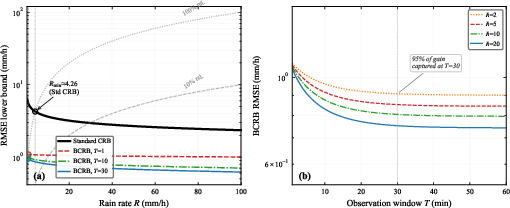
Figure 3: BCRB RMSE lower bound versus rain rate, demonstrating standard CRB and BCRB gains for 38∘7. Open circles indicate minimum detectable rain rate for each bound.
Temporal BCRB saturates at 38∘8 for 38∘9, capturing 95% of the temporal gain in Rmin≈4.30 min. Heavier rain improves sensing precision but penalizes spectral efficiency, motivating an adaptive pilot allocation.
Sensing–Communication Tradeoff and Dynamic Geometry
CRB depends on pilot fraction Rmin≈4.31 and spectral efficiency. The paper constructs the Pareto frontier between precision and rate: the temporal BCRB reaches the CRB's Rmin≈4.32 precision at Rmin≈4.33, enabling significant resource savings for communication.
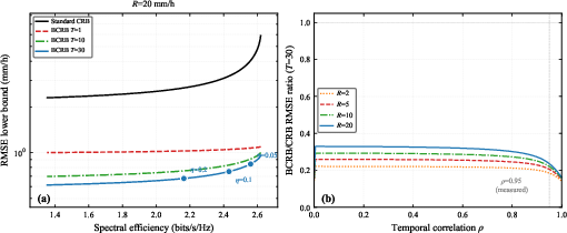
Figure 4: (a) Pareto frontier at Rmin≈4.34 mm/h. (b) BCRB/CRB ratio vs Rmin≈4.35, establishing temporal gain robustness to correlation estimation errors.
Dynamic LEO geometry is explored via effective slant path length and elevation. Sensing-optimal elevation that minimizes Rmin≈4.36 is analytically derived and found to lie at the ITU-R P.618 validity floor (Rmin≈4.37), yielding a Rmin≈4.38 improvement over the standard Rmin≈4.39 elevation. Sensing- and communication-optimal elevations are structurally anti-correlated throughout orbital passes and never coincide.
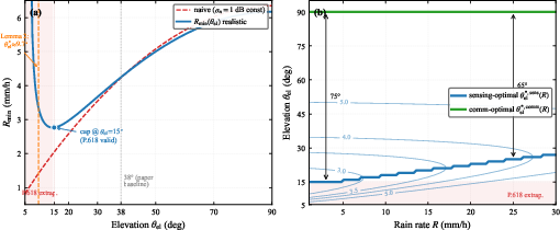
Figure 5: Sensing-optimal elevation minimizing K=50, showing geometric and SNR effects, and the angular gap from communication-optimal elevation.
Algorithm: Weather-Adaptive Pilot Allocation and Rain Detection
Weather-adaptive pilot allocation minimizes the BCRB subject to a hard spectral-efficiency constraint, leading to a three-regime structure: full sensing (low rain), throughput-tracking (moderate rain), and outage (heavy rain). The optimal pilot fraction K=51 decreases as rain increases, gracefully surrendering sensing resources to maintain throughput until outage.
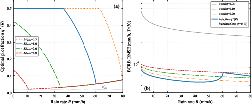
Figure 6: Adaptive K=52 for four K=53 values; BCRB comparison between adaptive and fixed pilot allocations.
Rain onset detection is implemented via a CUSUM detector, calibrated for a design rain rate K=54 mm/h. Detection delay is confirmed to remain below K=55 min for K=56 mm/h and below K=57 min for K=58 mm/h.
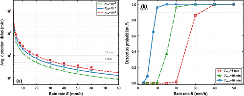
Figure 7: CUSUM detection delay versus rain rate, with theoretical and Monte Carlo agreement.
Model Validation, Multi-Link Fusion, and Case Studies
Validation is performed against 9.4 million radar samples from 215 GEO Ku-band satellite links and 113 rain gauges. The P.838+P.618 attenuation model confirms high fidelity (K=59, RMSE=(R,G)0 dB), and path-averaged rain estimation matches gauge decorrelation scales. Multi-link fusion robustly achieves (R,G)1 scaling, with BCRB RMSE at (R,G)2 mm/h dropping to (R,G)3 mm/h for (R,G)4.
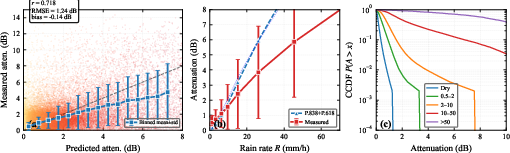
Figure 8: Predicted versus measured attenuation, binned attenuation vs rain rate, and attenuation CCDF by rain category.
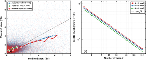
Figure 9: Per-satellite scatter consistency and BCRB RMSE scaling vs (R,G)5 ((R,G)6).
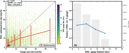
Figure 10: Gauge validation—SML estimates vs gauges and spatial decorrelation at (R,G)75 km distance.
Representative event time series highlight rapid attenuation tracking in convective rain and slow envelope following in stratiform rain, showcasing the model's utility.
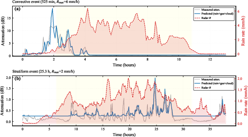
Figure 11: (a) Convective event: predicted attenuation tracks rapid onset/peak. (b) Stratiform event: predicted attenuation with baseline follows measured envelope.
Conclusion
Bayesian estimation theory establishes the minimum detectable rain rate and RMSE lower bounds for Ku-band LEO OFDM downlinks, with substantial gains through prior exploitation, temporal correlation, and spatial multi-link fusion. Adaptive pilot allocation provides robust weather-resilience in spectral efficiency, and dynamic elevation selection yields geometric improvements for sensing. Validation demonstrates high accuracy and operational feasibility of the attenuation model, with the analytical bounds transferring seamlessly to LEO constellations. Future directions include elevation-aware pilot optimization, dual-frequency estimation, LEO-specific campaign validation, and spatial field reconstruction, deepening the integration of opportunistic satellite sensing in environmental monitoring and ISAC.