- The paper advances immersive analytics by integrating tangible terrain models and real-time simulation to bridge abstraction barriers in dynamic landslide risk analysis.
- Methodologically, it combines mixed reality, embodied interaction, and computational steering to support hypothesis-driven exploration and immediate feedback.
- Empirical evaluation demonstrates improved situational awareness across perception, comprehension, and projection, aiding effective risk mitigation.
Immersive Analytics for Landslide Risk: A Critical Analysis of LandSAR
Introduction
Landslide risk assessment remains a paramount challenge in geotechnical engineering and disaster management, particularly under the intensifying effects of climate change. While computational simulation has become essential to approximate dynamic landslide processes, the resultant high-dimensional, temporally-varying datasets impose significant cognitive burdens on analysts. "LandSAR: Visceralizing Landslide Data for Enhanced Situational Awareness in Immersive Analytics" (2604.09241) addresses these issues by integrating immersive analytics, data physicalization, and simulation-based visceralization. The objective is to synthesize analytical (symbolic, data-centric) and intuitive (sensorimotor, embodied) analytical modes to enhance all three levels of situational awareness (SA) — perception, comprehension, and projection — for landslide risk analysis.
Problem Characterization: Data Abstraction and the Cognitive Gap
The paper delineates the multidimensional nature of landslide risk, mapping key components including rainfall, slope, landslide mechanics, risk, and rigid barriers used for mitigation.
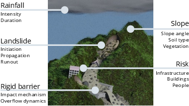
Figure 1: Main components in landslide risk analysis, encompassing environmental triggers, terrain susceptibility, hazard dynamics, risk to populations and infrastructure, and engineered barriers.
Traditional post-event analysis is restricted to static outcomes, rendering the dynamic initiation, propagation, and runout processes unobservable. Computational simulations theoretically address these gaps but introduce a new abstraction barrier: analysts must mentally reconstruct four-dimensional physical phenomena (three spatial, one temporal) from symbolic visual encodings. This undermines both comprehension (SA Level 2) and projection (SA Level 3). The need for embodied analysis — linking domain expertise with kinesthetic, spatial intuition — is highlighted through iterative co-design with domain experts.
System Design: The LandSAR Architecture
LandSAR operationalizes a hybrid immersive analytics environment linking the physical and virtual worlds.
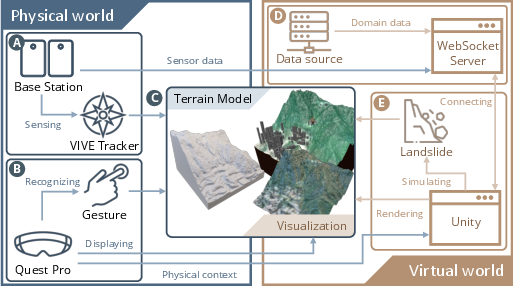
Figure 2: LandSAR system pipeline, fusing tangible interaction (AR HMD, VIVE trackers, terrain models) with real-time simulation and visualization rendered in Unity.
Key Components:
- Physical Terrain Models: High-fidelity 3D-printed proxies serve as haptic anchors, reducing spatial ambiguity and supporting direct, tangible spatial queries.
- Mixed Reality Headsets: MR HMDs enable both exocentric and egocentric perspectives, blending AR for overview and VR for immersive, embodied experience.
- Real-Time Simulation: A computational steering pipeline allows users to manipulate mitigation strategies (e.g., barrier placement), conducting interactive what-if analyses with immediate feedback via situated visualizations.
- Situated Analytics: Sensor data from interactions are streamed via WebSocket to synchronize physical manipulation with rendered visual encodings, supporting both analytical overlays and intuitive, dynamic visualization.
Visual and Experiential Synthesis
Situated Data Visualization
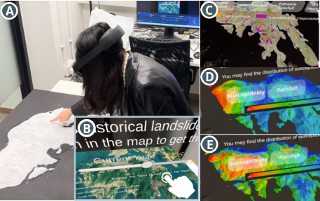
Figure 3: Situated visualizations deliver spatio-temporal analytics, with views for exploring historical events, rainfall-landslide causal relationships, and prospective climate scenarios.
- History View: Interactive exploration of landslide incidence over 37 years, enabling spatial and temporal pattern analysis.
- Causality View: Direct side-by-side heatmaps for rainfall intensity and landslide susceptibility, aligning domain knowledge with visual-spatial intuition.
- Climate Change View: Simulation-driven projections under extreme rainfall, facilitating hypothesis generation and what-if scenario testing.
Immersive Simulation Module
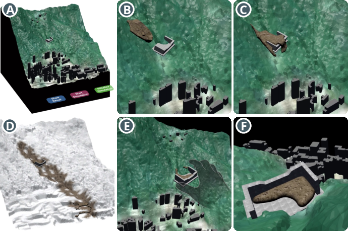
Figure 4: The dynamic landslide simulation enables users to position rigid barriers, observe real-time debris flow propagation, and switch between exocentric (overview) and egocentric (first-person) perspectives.
- Physical Manipulation: Rigid barriers are adjusted using tangible tracking, directly affecting simulated landslide runout and impact.
- Real-Time Dynamics: Debris flows are modeled using a simplified Moving Least Squares Material Point Method for interactive feedback.
- Risk Visualization: Hazard maps and vulnerability overlays are composited in situ, encoding impact force, flow velocity, building density, and population at risk.
Empirical Evaluation
Workshop and Expert Study
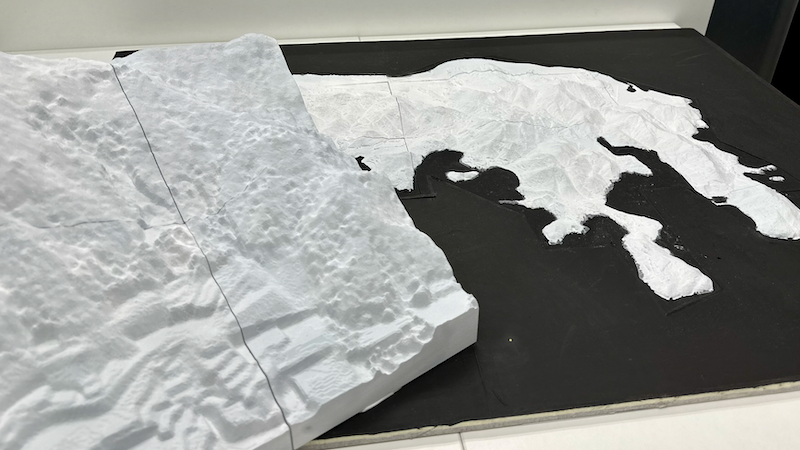
Figure 5: The tangible terrain models used for interaction, showcasing both regional and urban topographies.
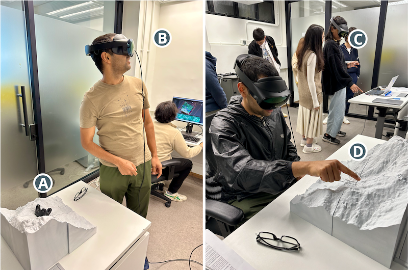
Figure 6: User engagement during evaluative workshops, comparing interaction with and without tangible terrain models, and experiencing first-person landslide perspectives.
LandSAR was subject to formative workshops (N=12) and expert interviews (N=3), leveraging mixed methods (questionnaires, UEQ, SART, and thematic interviews) to assess system impact on situational awareness and user engagement.
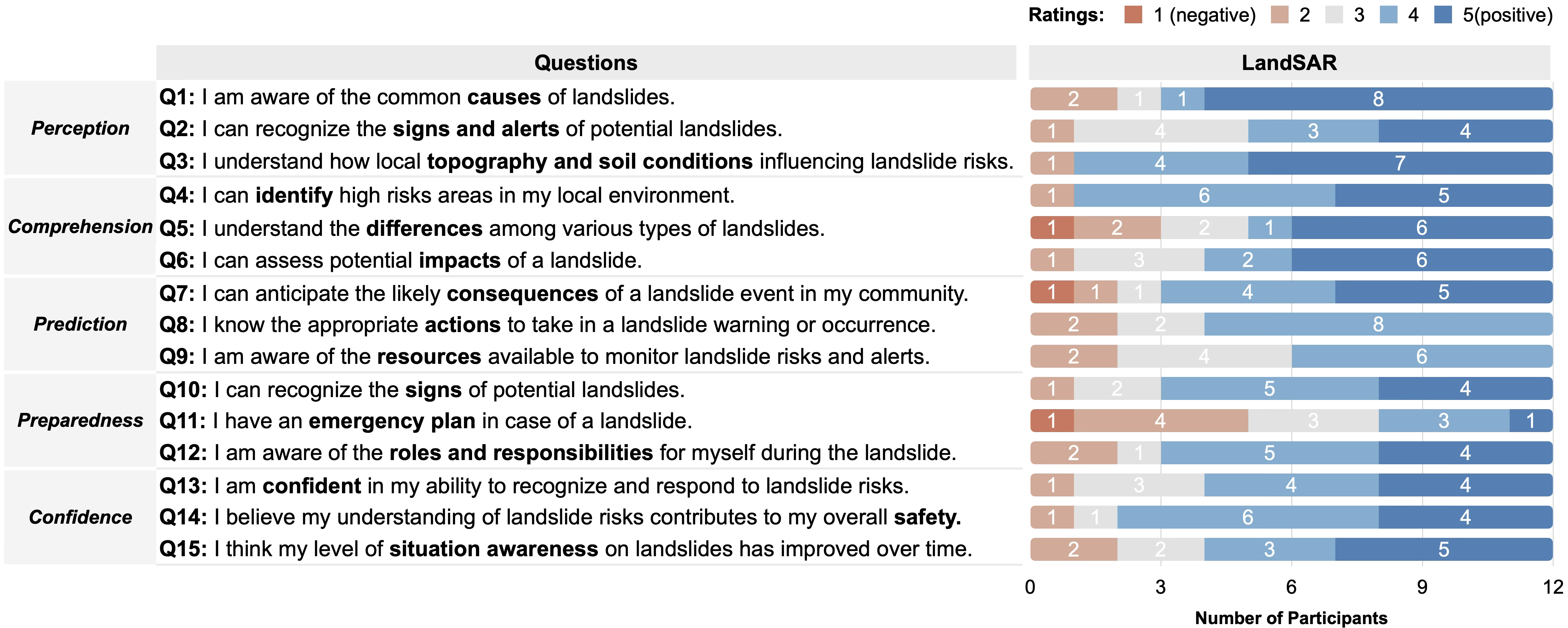
Figure 7: Participants’ self-reported baseline situational awareness for landslide events prior to using LandSAR.
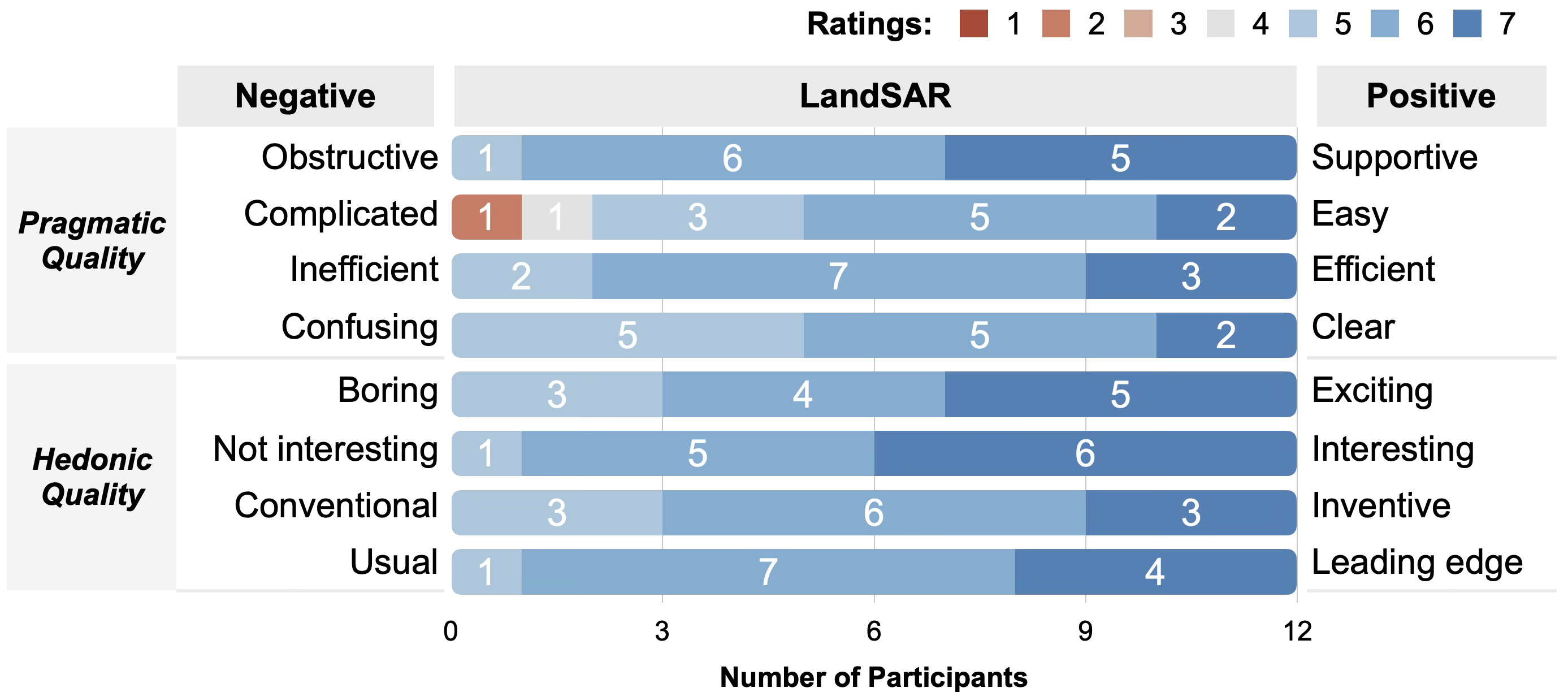
Figure 8: User Experience Questionnaire (UEQ) indicating strong support for clarity, effectiveness, and engagement.
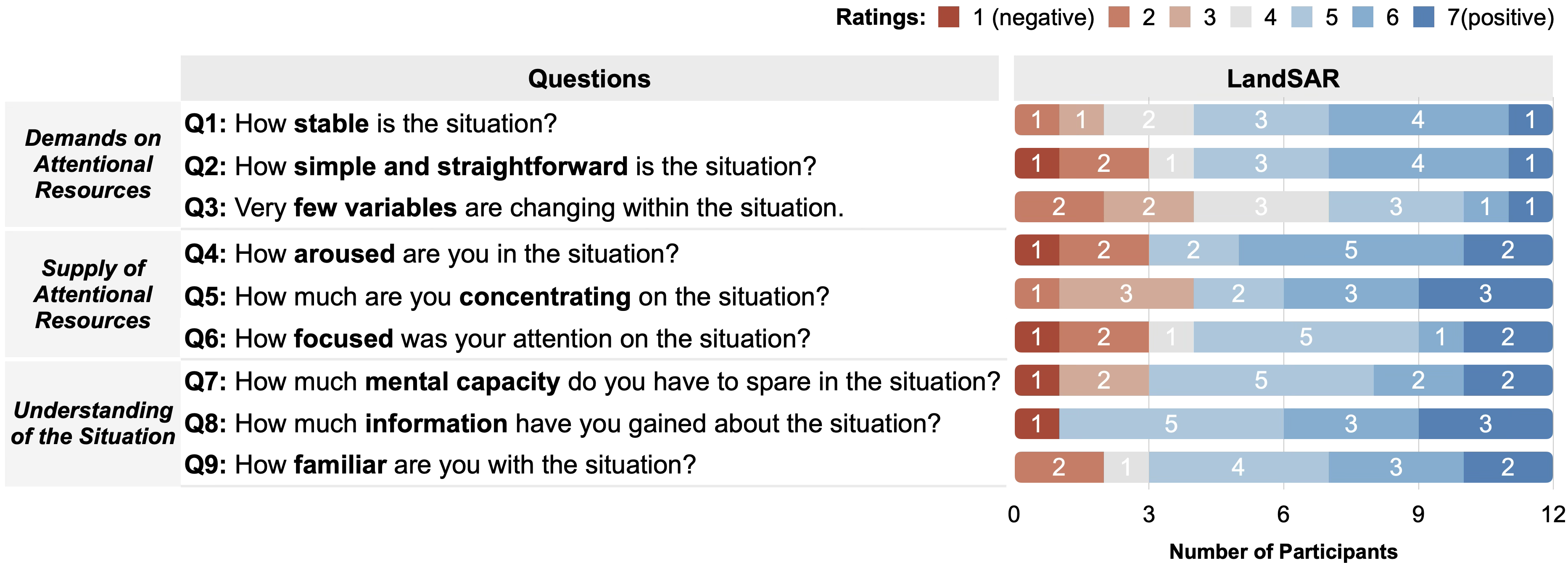
Figure 9: SART results reflect broad improvements in perceived situational awareness.
Key Findings
- First-Person Perspective: The egocentric viewpoint was reported as the most impactful, transforming users from spectators into stakeholders, supporting embodied understanding of hazard consequences and mitigation efficacy.
- Analytical-Intuitive Synthesis: Participants emphasized the value in combining situated visual analytics with live simulation, enabling seamless switching between hypothesis-driven analysis and experiential comprehension.
- Tangible Physicalization: Haptic interaction significantly mitigated the disembodied shortcomings of mid-air gestural interfaces, increasing precision in risk identification tasks.
- Domain Relevance: Experts valued LandSAR for preemptive exploration of mitigation options, noting its potential to reduce reliance on expensive or unsafe field reconnaissance.
Implications and Theoretical Contribution
LandSAR advances the paradigm of immersive analytics by directly addressing the integration challenge of analytical overlays and intuitive, embodied simulation. The architectural synthesis is mapped explicitly to the three levels of situational awareness:
- Level 1 (Perception): Analytical overlays promote rapid situational assimilation.
- Level 2 (Comprehension): Simulation-based visceralization supports deep mechanical understanding.
- Level 3 (Projection): Computational steering facilitates direct, real-time hypothesis testing.
By operationalizing data physicalization as both a cognitive and perceptual anchor, LandSAR demonstrates that high-fidelity tangible proxies can bridge the abstraction gap inherent in symbolic data analysis. Notably, the work surfaces ethical considerations for using realistic physical models in stakeholder-facing contexts, given the potential for misinterpretation of risk visualization.
Limitations and Future Work
While the real-time simulation module employs an efficient fluid-dynamics model, the absence of advanced rheological specificity for debris flow constrains physical accuracy. Future iterations should balance high-fidelity geotechnical simulation with system interactivity. Additional limitations include temporal control granularity (lacking fine-grained navigation and multi-event concurrency), scalability of the tangible platform, and latency in current HMD/AR streaming pipelines. Exploring hybrid physicalization (e.g., integrating malleable or actuated terrain for dynamic topography) represents a promising direction, as does the deployment of fully agnostic multi-user and collaborative capabilities.
Conclusion
LandSAR exemplifies a rigorous approach to immersive analytics in the expert-driven domain of landslide risk, achieving a robust synthesis between tangible physical interfaces and situated, real-time simulation. The system demonstrates both practical utility for verification and design in geotechnical applications, and theoretical value in operationalizing a framework for integrating analytical and intuitive modes within spatial-situational tasks. Future work should extend physical and computational fidelity, refine interactive modalities, and investigate the translation from expert tools to stakeholder communication frameworks.
Reference:
LandSAR: Visceralizing Landslide Data for Enhanced Situational Awareness in Immersive Analytics (2604.09241)