- The paper introduces a lightweight quantile regression framework added to a temporal 3D U-Net to estimate canopy height with calibrated uncertainty.
- It demonstrates that the method produces well-calibrated, interpretable uncertainty maps and competitive point-estimate accuracy compared to state-of-the-art baselines.
- The approach enhances ecological risk assessment by reducing prediction interval widths and highlighting spatial uncertainties near forest boundaries and rugged terrain.
Quantile Regression for Uncertainty-Aware Canopy Tree Height Estimation from Remote Sensing
Introduction and Motivation
Accurately estimating canopy tree height from satellite remote sensing data is fundamental to ecological monitoring, carbon accounting, and climate policy actions. Traditional approaches utilize point-estimate regressors trained on geospatial inputs, often neglecting uncertainty quantification due to scarcity of reliable, pixel-level ground truth and the computational demands of Bayesian/ensemble approaches. The study introduces a quantile regression framework as a lightweight, computationally efficient, and easily integrated alternative for incorporating predictive uncertainty in deep learning models for canopy height estimation (2604.06988).
The proposed approach addresses the gap in uncertainty quantification by adapting a standard tree height estimation pipeline—specifically a temporal 3D U-Net architecture—to produce conditional quantile estimates via a pinball loss-based uncertainty head. Empirical results demonstrate this method yields calibrated, interpretable uncertainty maps. These are crucial for propagating risk through downstream biomass models and for policy scenarios that require explicit quantification of prediction intervals.
Methodological Framework
Model Architecture and Adaptation
The backbone model is a temporal 3D U-Net ingesting time series of Sentinel-2 images and Sentinel-1 composites, with ground truth derived from GEDI spaceborne LiDAR data. The uncertainty head is a minimal architectural addition: a set of convolutional layers producing simultaneous predictions for multiple quantiles (τˉ=[0.05,...,0.95]). The model is fine-tuned via a shifted pixelwise pinball loss to account for systematic, track-based geolocation bias in GEDI training labels.
Shift-Resilient Pinball Loss
To mitigate label noise due to systematic spatial misalignment in LiDAR-derived tracks, a "shift-resilient" loss function allows each track to be spatially shifted up to one pixel in any of four directions, optimizing the overall loss for that track. This enhances robustness at spatial discontinuities, particularly at forest boundaries.
Uncertainty Quantification Metrics
The approach is evaluated using:
- Empirical Coverage (EC): Fraction of ground truth labels lying below a predicted quantile.
- Prediction Interval Width (PIW): Width between symmetric quantiles for a specified coverage level.
- Prediction Interval Coverage Probability (PICP): Actual fraction of labels contained within prediction intervals.
Fine-tuning targets both point estimate accuracy (via the median) and coverage calibration across quantiles and levels of predictive uncertainty.
Empirical Results
Quantile regression integration yields point-estimate accuracy essentially identical to the state-of-the-art deterministic baselines. Minor differences in Mean Squared Error (MSE), Mean Absolute Error (MAE), and R2 remain statistically insignificant following architectural modification and head fine-tuning.
Uncertainty Calibration
The proposed method produces well-calibrated quantile intervals, achieving empirical coverage within 2−3% of nominal targets across most bins, aside from tall vegetation outliers where calibration systematically underestimates uncertainty. Notably, mean prediction interval widths are roughly half those of the prior Gaussian regression ensemble baseline [Lang et al.].
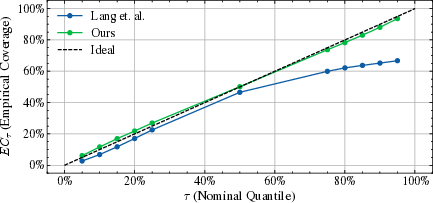
Figure 1: Comparison of empirical coverage against nominal quantile for the baseline and proposed quantile regression models.
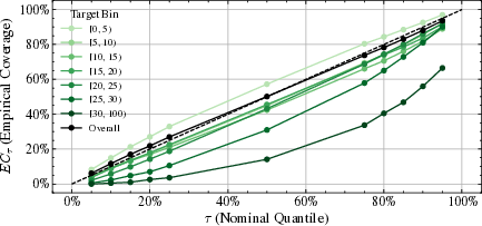
Figure 2: Empirical coverage over different target bins, revealing quantile undercoverage in tall canopy scenarios.
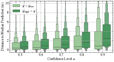
Figure 3: Asymmetry in prediction intervals, with right-skewed (upper) deviations from the median dominating, particularly for higher coverage levels.
Spatial and Structural Analysis of Uncertainty
Uncertainty is highest near forest boundaries and in regions of steep topographic relief, consistent with areas of increased label noise or geolocation error. Shift-resilient loss leads to lower uncertainty (tighter intervals) specifically at boundaries compared to naive approaches. Points with low predicted uncertainty but large ground truth error routinely reveal label inconsistencies (potentially corrupted GEDI samples), suggesting a direction for automated training set denoising.
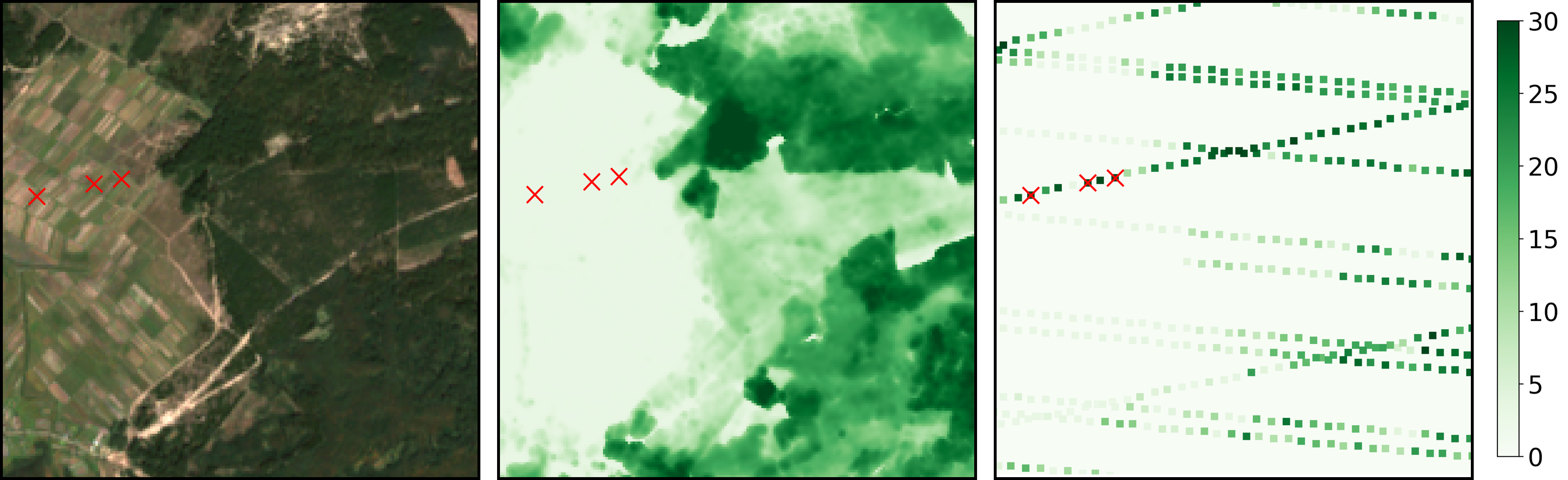
Figure 4: Illustration of noisy GEDI labels; high-confidence low-height predictions with mismatched high ground truth values (potential labeling artifacts).
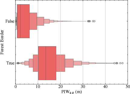
Figure 5: Boxplot of prediction interval width at α=0.8 for forest border and non-border regions, indicating elevated model uncertainty at spatial discontinuities.

Figure 6: Dependence of prediction interval width on local average slope, confirming increased uncertainty in mountaineous terrain.
Qualitative and Visual Results
The spatial patterning of uncertainty in output maps enables direct visual identification of ecotones, boundaries, and likely input anomalies.
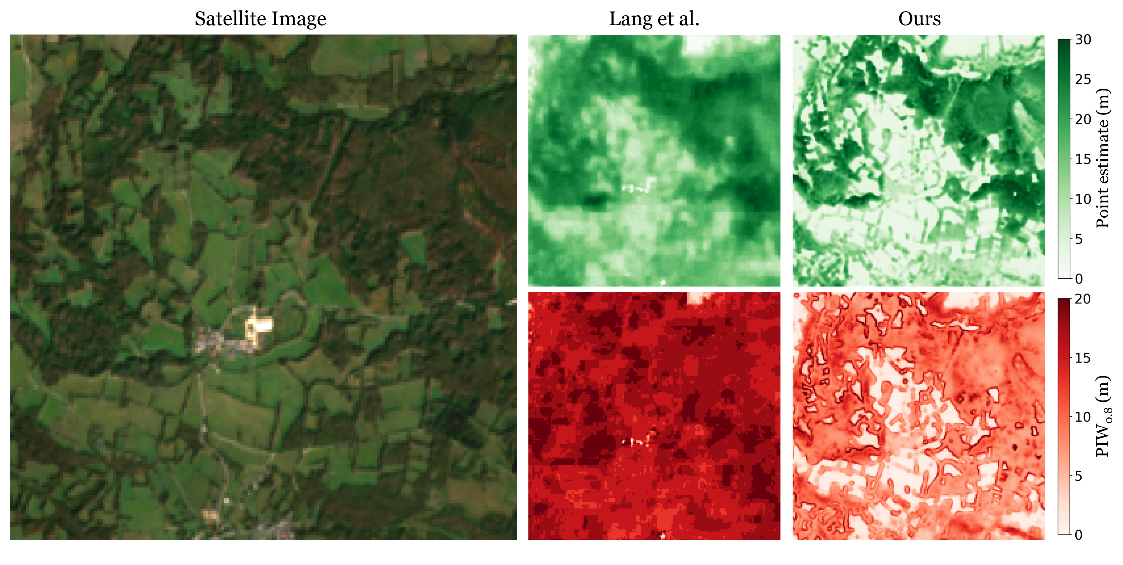
Figure 7: Sample uncertainty and point-estimate maps from the baseline model, illustrating broad and high-variance intervals over forested regions.
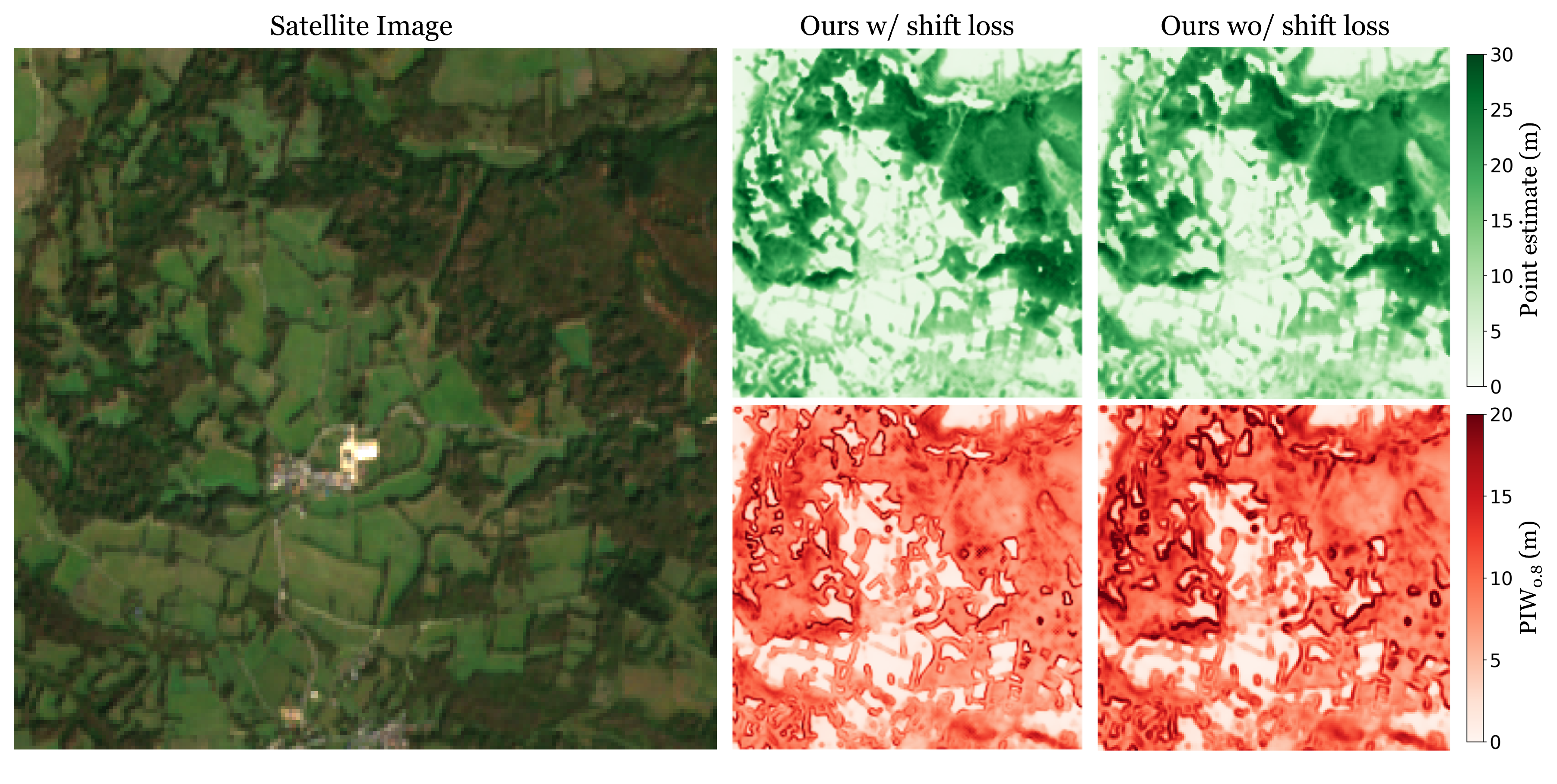
Figure 8: Qualitative comparison of predicted uncertainty maps with and without shift loss, showing reduced border uncertainty after loss adaptation.
Theoretical and Practical Implications
The study demonstrates that calibrated, spatially resolved predictive uncertainty can be efficiently achieved as a head extension to standard deep networks using quantile regression, with negligible computational overhead. The approach is robust to systematic label errors and aligns with known sources of epistemic and aleatoric uncertainty inherent to remote sensing (e.g., forest borders, steep slopes). As such, these advances are directly applicable to risk-sensitive tasks including carbon stock modeling, ecological change detection, and targeted field sampling.
Furthermore, the model's inability to fully calibrate tall canopy predictions highlights inherent limitations due to ground truth quality and sampling sparsity. Future research directions include:
- Automated label denoising using model-confidence patterns
- Explicit modeling of geolocation uncertainty along with prediction
- Integration into multi-task frameworks for joint height–biomass–structure prediction
Conclusion
Quantile regression, applied as a lightweight add-on to pretrained deep learning models, provides accurate, well-calibrated, and interpretable uncertainty quantification for canopy tree height estimation from satellite imagery. The proposed uncertainty head improves upon prior Gaussian ensemble baselines in both interval sharpness and calibration, while producing actionable spatial uncertainty maps that correspond to domain-relevant challenges such as forest boundaries and rugged terrain.
This methodological advance supports reliable downstream ecological products, strengthens carbon accounting mechanisms, and opens avenues for robust, risk-aware integration of remote sensing in climate and resource policy models. Further work into interpretable label noise detection and improved calibration in underrepresented strata can extend these benefits across broader environmental monitoring tasks.

