- The paper provides the first comprehensive survey of MIMO OFDM-enabled ISAC for UAV surveillance, outlining methods to detect, track, and identify non-cooperative UAVs in low-altitude settings.
- The study details advanced signal processing and waveform design techniques, including pilot-based and random-data-assisted sensing, to overcome challenges like urban clutter and rapid Doppler shifts.
- Experimental validations demonstrate real-time tracking, sub-meter localization accuracy, and the feasibility of leveraging existing cellular infrastructures for scalable UAV detection.
Survey of MIMO OFDM-Enabled ISAC for Low-Altitude Non-Cooperative UAV Surveillance
Introduction and Motivation
The proliferation of unmanned aerial vehicles (UAVs) in low-altitude airspace necessitates robust surveillance solutions to mitigate emerging safety and security risks. Traditional approaches—dedicated radar, vision-based systems, multi-sensor fusion—face scalability and cost limitations. Integrated sensing and communication (ISAC) frameworks, leveraging cellular infrastructure and advanced waveform/antenna paradigms such as multiple-input multiple-output (MIMO) and orthogonal frequency-division multiplexing (OFDM), offer an avenue for ubiquitously monitoring non-cooperative UAVs with minimal incremental hardware investment.
This paper delivers the first in-depth survey focused specifically on MIMO OFDM-enabled ISAC for low-altitude, non-cooperative UAV surveillance, encompassing propagation challenges, waveform and system design, detection/tracking and identification algorithms, experimental validations, and open research frontiers.
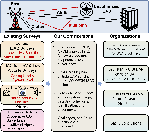
Figure 1: Overview of the surveyed topics and contributions covered in this paper.
Signal, Channel, and System Characteristics
UAV-ISAC systems operate under unique propagation, channel, and operational conditions distinct from other ISAC or sensing scenarios. Key characteristics include:
- Low-altitude clutter and multipath: Dense urban/ground environments introduce severe static/dynamic clutter and rich multipath, complicating target detection and elevating the risk of ghost/false alarms.
- Rapid channel variations: High-mobility UAV behavior leads to large Doppler spreads, rapid phase/amplitude fluctuation, intermittent LOS conditions, and reduced coherence intervals, challenging both tracking stability and delay-Doppler separability.
- Near-/far-field coexistence: Flexible UAV trajectories yield mixed-field effects; large-aperture mmWave MIMO arrays further exacerbate near-field prevalence, requiring unified signal models and robust parameter estimation algorithms.
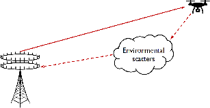
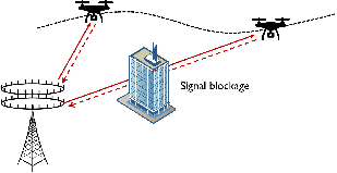
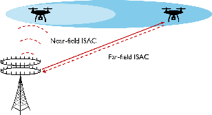
Figure 2: Illustration of the key environmental and propagation characteristics for UAV-ISAC—clutter/multipath, signal intermittency, and coexisting near-/far-field regimes.
MIMO and OFDM are the technological enablers in this context: MIMO supplies angular resolution and beamforming agility, while OFDM provides high delay-Doppler resolution, resource allocation flexibility, and compatibility with existing cellular standards.
MIMO OFDM Signaling Design for ISAC
Waveform design for UAV-ISAC follows three overarching strategies—sensing-centric (radar-first), communication-centric (OFDM-first), and joint optimization. Current practice emphasizes communication-centric approaches, reusing standard OFDM-based signals (pilot and data) for both functions due to their hardware compatibility.
Pilot-based Sensing: Reuse of reference signals such as SSB/PRS/DMRS for sensing enables integration with 3GPP systems. Recent advances include multi-stage signal processing for coarse/fine estimation, adaptive resource allocation for balancing sensing coverage and resolution, and algorithmic suppression of sidelobe/ambiguity artifacts.
Random-data-assisted Sensing: ISAC frameworks that jointly exploit deterministic pilots and random data payloads facilitate enhanced Doppler accumulation, improved tracking fidelity, and close-to-theoretical bounds for joint communication-sensing performance. Dedicated precoding, pulse shaping (e.g., iceberg shaping), and hybrid signal models advance both analytical tractability and practical accuracy.
Mixed Near-/Far-field Channel Models: Hybrid-field propagation models and associated optimization algorithms (SCA, Dinkelbach-based, semidefinite relaxation) are actively studied for beamforming, localization, and user/target assignment, mitigating performance loss in transition regimes.
System-Level Design and Cooperative Architectures
UAV surveillance mandates networked, multi-BS operation for persistent, wide-area coverage and handover resilience. Research converges around several design axes:
- Sensing cell and network topology formation: 3D cell definition incorporating antenna FOV constraints, coverage modeling, and vertical domain extension for seamless monitoring.
- Cooperative beamforming: Centralized/distributed frameworks maximizing SCNR and communication rates, including RIS-assisted systems for flexible path engineering.
- Resource allocation, multi-BS handover, and trajectory design: Optimization methods that jointly consider target association, beamforming, UAV mobility, and scheduling, employing AO, SCA, fractional programming, and fairness constraints.
- Edge and fusion architectures: Hierarchical pipelines with local pre-processing, EKF-based multi-BS fusion, and low-latency, scalable information exchange.
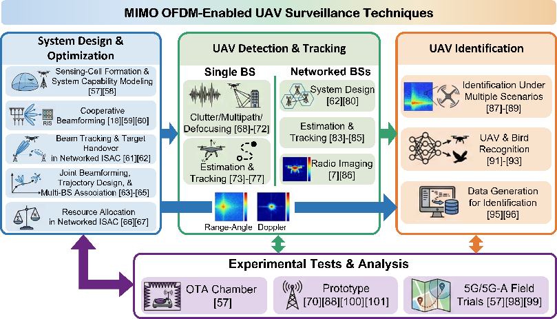
Figure 3: MIMO OFDM-enabled UAV surveillance algorithmic techniques, including beamforming, tracking, cooperative transmission, and sensing.
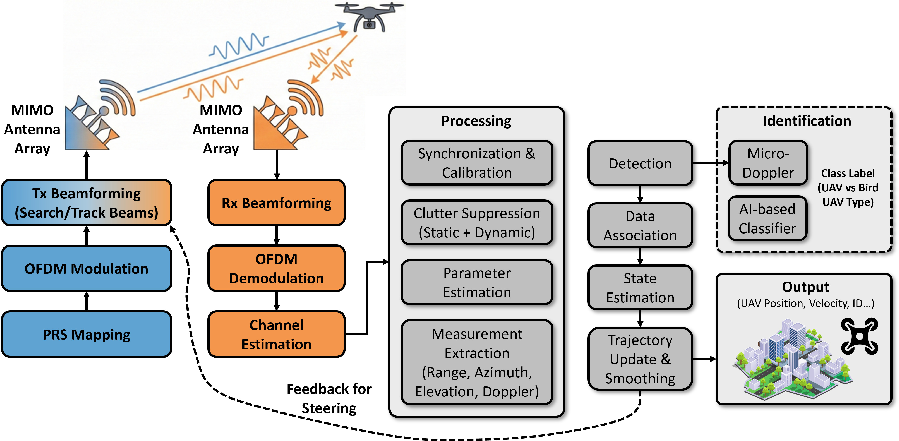
Figure 4: A general architecture for MIMO OFDM-based ISAC UAV surveillance, covering waveform generation, MIMO beamforming, signal synchronization, parameter estimation, detection, tracking, and AI-based identification.
Detection, Tracking, and Identification Algorithms
Detection and Tracking
For single-BS scenarios, robust detection under clutter/multipath is pursued via clutter-aware channel models, adaptive spectrum estimation, multi-path association through deep learning on micro-Doppler signatures, and ISAR imaging with entropy-minimizing compensation for motion-induced blurring. Localization leverages tensor decompositions, ESPRIT for 6D kinematics, and model-mismatch-aware CRLBs. Real-time, resilient tracking relies on multi-model Kalman filtering, occlusion-aware interpolation, and trajectory smoothing.
In networked-BS contexts, cooperative detection and high-accuracy localization draw on multi-BS signal fusion, delay-Doppler aggregation, minimum-spanning-tree-based data association, and compressed sensing for radio image reconstruction, including physics-embedded deep learning for off-grid enhancement.
Identification
UAV identification post-detection focuses on micro-Doppler feature extraction, learning-based type classification (PinpuNet, DC-Former), and discriminative analysis to separate UAVs from birds and ambient aerial objects. Rotors' micro-Doppler patterns, utilizing optimized TDD frames, are leveraged for fine-grained recognition. Data scarcity is addressed via synthetic micro-Doppler datasets, high-fidelity modeling, and spectral augmentation.
Experimental Validation
A variety of field trials and prototype deployments validate simulation findings:
- mmWave and sub-6 GHz BSs equipped for ISAC demonstrate robust tracking at ≥1 km, sub-meter localization accuracy, and real-time clutter suppression, even in dense urban environments.
- Hardware-in-the-loop experiments showcase real-world feasibility for micro-Doppler feature extraction and robust tracking under urban and maritime scenarios.
- Commercial 5G/5G-A/6G platforms, using unmodified infrastructure, confirm practical viability for wide-area ISAC-based UAV surveillance with low incremental deployment cost.
Open Issues and Research Directions
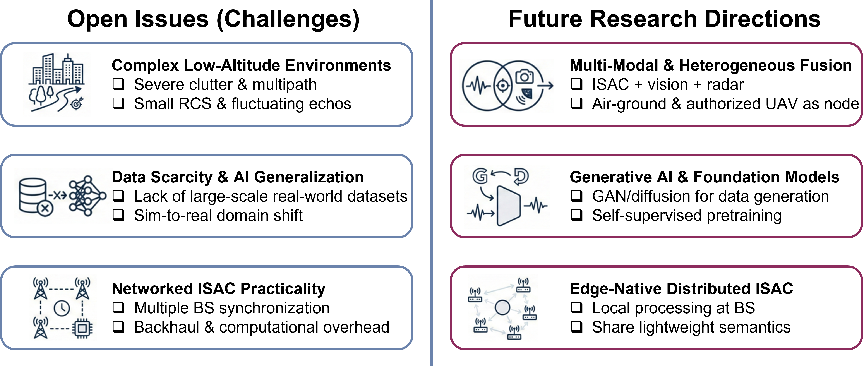
Figure 5: Summary of outstanding challenges and future research opportunities.
Technical Bottlenecks
- Severe Clutter and Small RCS: Diminished SCNR due to strong clutter and UAVs' fluctuating/small RCS remains a key performance limiter, especially in urban and cell-edge scenarios.
- Dataset Scarcity and Generalization: Training data for deep learning identification/classification is limited, and models trained on simulated data often fail in deployment due to domain shifts.
- Synchronization and Overhead in Multi-BS Fusion: Achieving precise time/phase alignment and managing the backhaul burden for centralized or even distributed, non-coherent fusion is challenging for real-time, wide-area ISAC.
Research Opportunities
- Multi-modal and 3D Network Fusion: Integrating ISAC with vision, LiDAR, or infrared, as well as fusing aerial and terrestrial sensing nodes, could greatly enhance coverage and semantic discrimination.
- Generative AI for RF Sensing: Foundation models and generative architectures (GANs, diffusion models) offer promise for scaling up RF datasets and achieving domain-robust sensing/identification.
- Edge-native, distributed ISAC: Moving toward fully distributed, asynchronous, and non-coherent fusion, supported by local pre-processing and lightweight semantic sharing, can relax engineering constraints and scale to city-wide coverage.
Conclusion
This survey establishes MIMO OFDM-enabled ISAC as a foundation for practical, scalable, infrastructure-efficient low-altitude UAV surveillance. It contextualizes recent advances in waveform/signal processing, networked system design, detection/tracking, and AI-based identification, drawing attention to the remaining challenges around physical clutter, generalizability, and multi-agent integration. Translational research in scalable dataset generation, multi-modal fusion, and edge intelligence will accelerate the path from proof-of-concept deployments to pervasive, intelligent airspace surveillance enabling secure, resilient low-altitude operations.

