- The paper introduces MoonAnything, a unified benchmark that combines over 130,000 samples for supervised lunar perception using both geometric and photometric data.
- It integrates two sub-datasets—LunarGeo and LunarPhoto—to support tasks like 3D reconstruction, pose estimation, and reflectance analysis under extreme illumination and low-texture conditions.
- Experimental results reveal significant reductions in reconstruction errors, validating the dataset's effectiveness in generalizing across diverse lunar terrains and mission-specific imaging scenarios.
MoonAnything: A Comprehensive Vision Benchmark for Large-Scale Supervised Lunar Data
Motivation and Problem Statement
Robust computer vision for lunar exploration is limited by the absence of large-scale, physically-realistic, and task-diverse datasets that provide both geometric and photometric supervision. Lunar surface perception demands 3D understanding and illumination-robust modeling under extreme contrast, weak texture, and substantial domain shifts from terrestrial imagery. Unlike the Earth-centric datasets fueling progress in geometric deep learning, existing lunar datasets are partitioned, either focused on geometry without realistic appearance or with photometric cues but lacking dense geometry. Several high-resolution orbital and surface datasets exist, yet none offer comprehensive annotations for end-to-end supervised learning, especially under varying illuminations.
Benchmark Construction
MoonAnything is constructed as a unified benchmark supporting both geometric and photometric perception. It is built upon real lunar topography and incorporates physically-based rendering to generate both stereo image pairs (for dense geometry) and multi-illumination photorealistic images (for material reflectance and robustness evaluation), systematically filling critical gaps in all previous datasets.
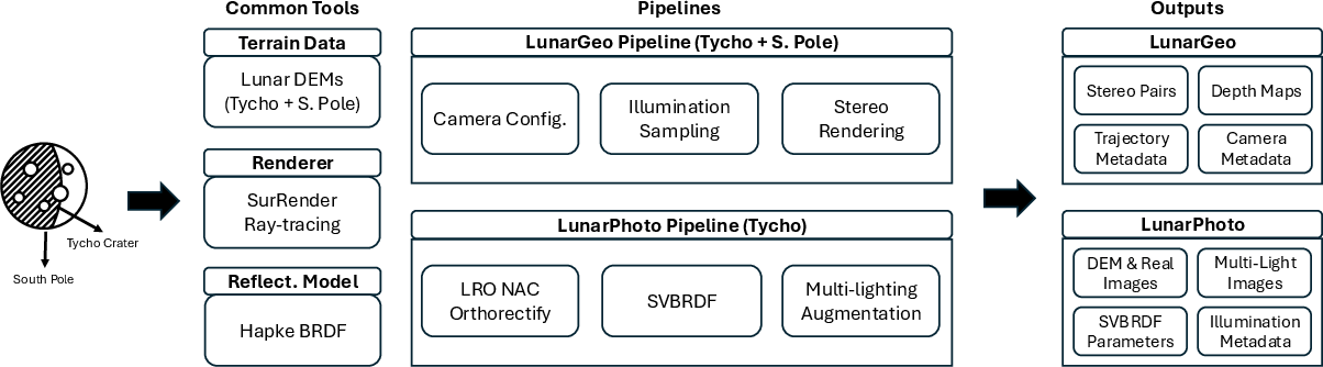
Figure 1: Overview of the MoonAnything dataset generation pipeline, highlighting integration of lunar DEMs, orbital imagery, SVBRDF, and rendering for both geometry and appearance data.
MoonAnything consists of two complementary sub-datasets:
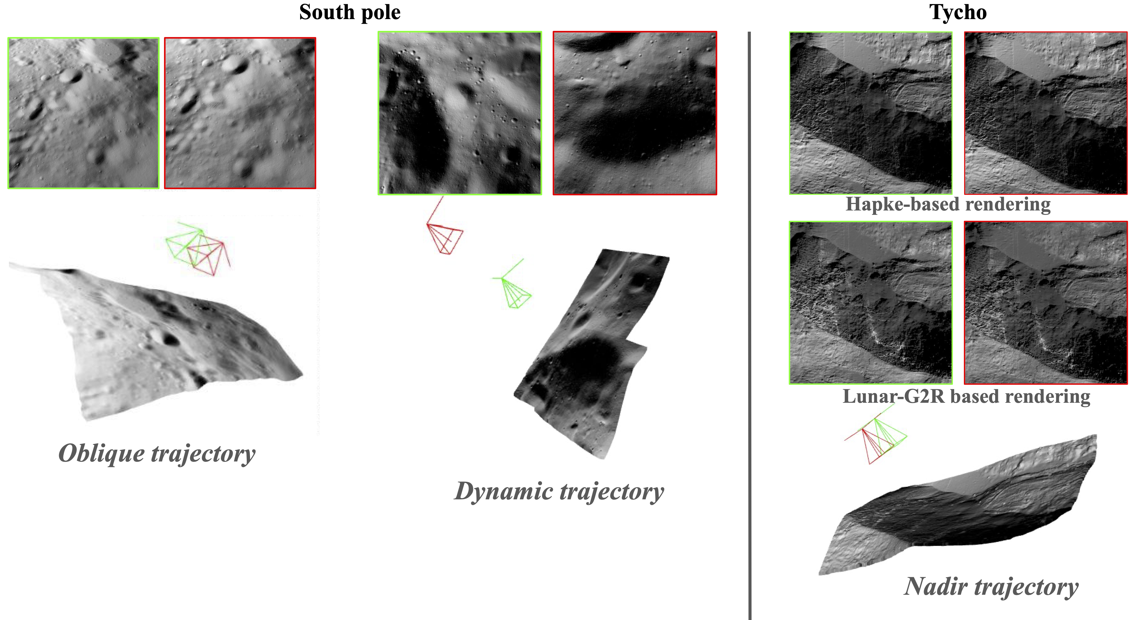
MoonAnything exceeds precedent with over 130,000 samples and more than 750,000 rendered images, spanning two key lunar environments: the South Pole (target of upcoming Artemis missions with permanent low-angle sunlight and extreme shadowing) and Tycho crater (mid-latitude, diverse geomorphology).
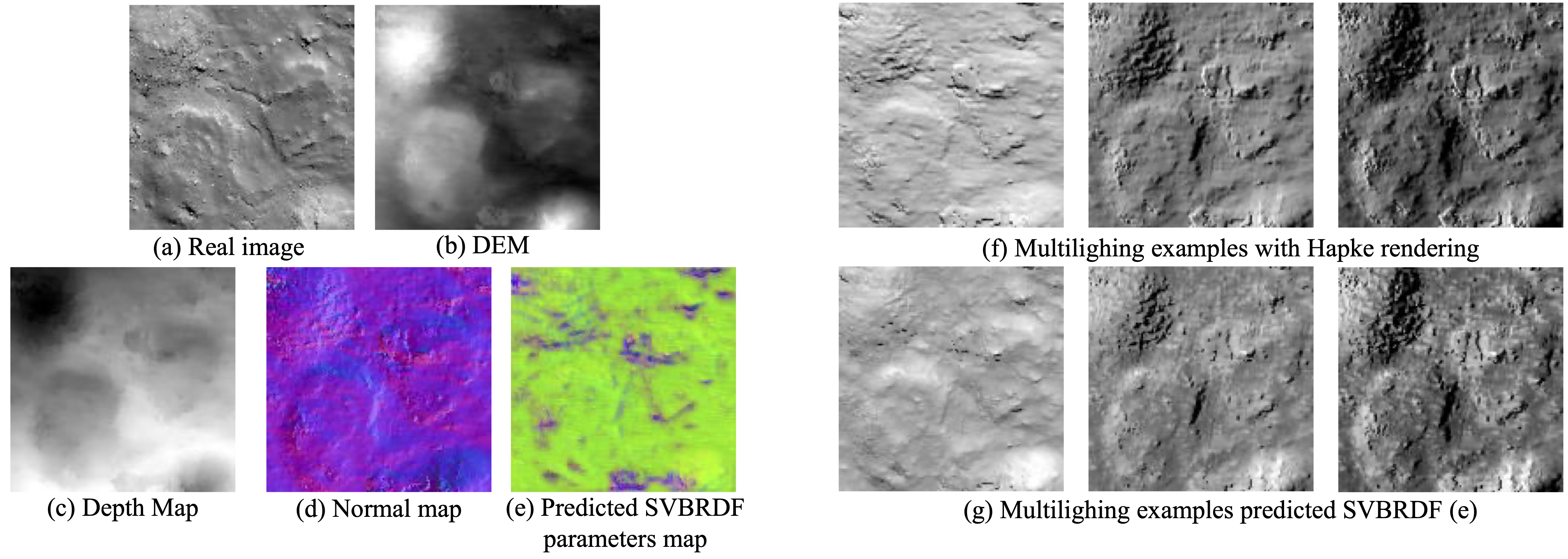
Figure 3: Samples from LunarPhoto, including a real LRO NAC image, DEM crop, depth map, normal map, per-pixel SVBRDF parameters, and multi-illumination renderings.
Dataset Characteristics and Challenges
MoonAnything purposely comprises scenarios characterized by:
- Low-texture, high-contrast imagery derived from physically-based rendering.
- Challenging illumination: extreme shadow boundaries, large cast shadows, and high intra-scene contrast.
- Regional reflectance variation through per-pixel learned SVBRDF maps capturing complex lunar regolith properties, including opposition effect and anisotropy.
- Acquisition geometry mimicking actual mission profiles (nadir, oblique, dynamic) with varying baselines, altitudes, and view angles across real lunar terrain.

Figure 4: Challenging cases including harsh shadows, raking illumination, and nearly textureless flat regions as seen in both geometric and photometric data, exemplifying scenarios difficult for conventional feature-based and model-based methods.
These properties make MoonAnything not only critical for lunar robotics but a valuable testbed for multimodal 3D vision, robust feature learning, and methods generalization to other airless planetary bodies or texture-poor domains.
Data Generation Pipeline
- Geometry: DEMs (resolution up to 1 m/pixel for Tycho) are derived from NASA’s LRO LOLA and stereo-matched imaging products, providing topographically accurate ground truth.
- Rendering: SurRender engine is used to simulate physically consistent images driven by Hapke-based reflectance (both constant and SVBRDF), spatially referencing camera and Sun geometry with selenographic accuracy.
- BRDFs: The Hapke model and its SVBRDF extension account for the photometric opposition effect and surface scattering diversity, with parameters learned from real multi-angle LRO NAC imagery.
- Camera and Illumination: Cameras are sampled according to mission-inspired descent and flyover trajectories with realistic FOV, baseline, and GSD; illumination is systematically varied via solar position sampling from the NASA SPICE toolkit, ensuring that all rendered conditions are achievable in real lunar contexts.
Experimental Baselines and Results
MoonAnything is used to fine-tune recent state-of-the-art stereo 3D reconstruction methods (MASt3R [leroy2024mast3r] and VGGT [wang2025vggt]). Quantitative evaluation on both seen (South Pole) and unseen (Tycho) regions with nadir, oblique, and dynamic trajectories reveals:
- Fine-tuned models achieve an order of magnitude reduction in reconstruction errors (accuracy, completeness, Chamfer distance) compared to initial models trained only on terrestrial or synthetic non-lunar domains.
- Notably, generalization to unseen lunar regions is strong when models are fine-tuned with only a subset of MoonAnything, validating the realism and diversity of the dataset.
The task difficulty is dominated by solar geometry, shadows, and terrain structure, which in MoonAnything are independently controllable and well-annotated.
Implications and Future Developments
MoonAnything constitutes the first large-scale, realistic, unified dataset for lunar geometric and photometric vision. Its key implications are:
- For algorithmic development: Enables fully supervised training and benchmarking of stereo, depth, reflectance, and photometric stereo methods where both geometry and reflectance are explicitly annotated under variable illumination.
- For mission design: Provides a simulation testbed enabling robust evaluation of terrain-relative navigation, hazard detection, and landing site selection under lunar-realistic constraints.
- For generalization research: Offers a benchmark for studying transfer learning, domain adaptation, and the robustness of SOTA geometric transformers and neural radiance field methods under high-contrast, low-texture, and domain-shifted conditions.
- For surface appearance modeling: Advances learning-based BRDF and intrinsic decomposition approaches for airless bodies, aligning with planetary science requirements.
Practically, the benchmark may be extended both by the authors and the community (with released code and generation tools) to novel geographic locales, sensor geometries, higher-resolution data, or multi-modal sensor combinations (e.g., fusion with event cameras or LiDAR).
Conclusion
MoonAnything (2604.00682) decisively advances lunar computer vision research by providing the first unified, large-scale, physically-real benchmark simultaneously enabling geometric and photometric supervision. It supports training and fair comparison of algorithms across stereo 3D vision, material reflectance estimation, and illumination-robust perception, directly facilitating the development of algorithms essential for future lunar and planetary exploration. Its structure and content ensure adaptability to broader computer vision challenges, with immediate application in robust perception for autonomous systems operating in extreme and under-constrained environments.