- The paper demonstrates that fine-tuned geospatial foundation models can accurately detect and simulate urban heat islands using high-resolution land surface temperature predictions.
- The methodology leverages a SWIN Transformer pre-trained on global Earth observation data, achieving improved MAE from 0.302°C to 0.199°C in modeling cooling effects.
- The approach enables reliable extrapolation to extreme UHI events and generalizes across European cities, offering actionable insights for urban climate resilience planning.
Fine-Tuned Geospatial Foundation Models for Urban Heat Island Detection and Microclimate Simulation
Introduction
The paper presents a rigorous evaluation and application of a fine-tuned geospatial foundation model (GFM) for the detection, simulation, and mitigation planning of urban heat islands (UHI). The study addresses the limitations of conventional machine learning approaches in urban climate analysis, particularly their dependence on large labeled datasets and poor generalization in data-scarce regions. By leveraging the Granite-Geospatial-Land-Surface-Temperature (Granite-GFM) model, which is based on a SWIN Transformer architecture and pre-trained on global Earth observation data, the authors demonstrate robust generalization and high-resolution prediction capabilities for land surface temperature (LST) across diverse urban environments.
Methodological Framework
The experimental workflow is structured into three phases: empirical ground truth establishment, model extrapolation under future climate scenarios, and simulation of urban greening interventions via guided inpainting. The empirical baseline quantifies internal and spillover cooling effects of urban green spaces by overlaying LULC maps with high-resolution LST imagery. The model's extrapolation ability is tested in Brașov, Romania, an unseen city, by fine-tuning on the cooler 90% of observations and evaluating predictions on the hottest 10%. Future UHI conditions are projected using EURO-CORDEX climate inputs under RCP 2.6, 4.5, and 8.5 scenarios. The inpainting experiment simulates the thermal impact of converting built-up areas to green spaces, adjusting input spectral indices accordingly.
Empirical Analysis of Urban Cooling Effects
The ground truth analysis reveals a mean UHI intensity of +3.3∘C in dense urban cores, with tree cover consistently located in the coolest zones. Parks exhibit pronounced internal cooling, with temperature reductions up to −2.6∘C within 200 meters of the edge, and spillover cooling effects extending up to −3.5∘C in adjacent built-up areas, attenuating to −1∘C at 150 meters.
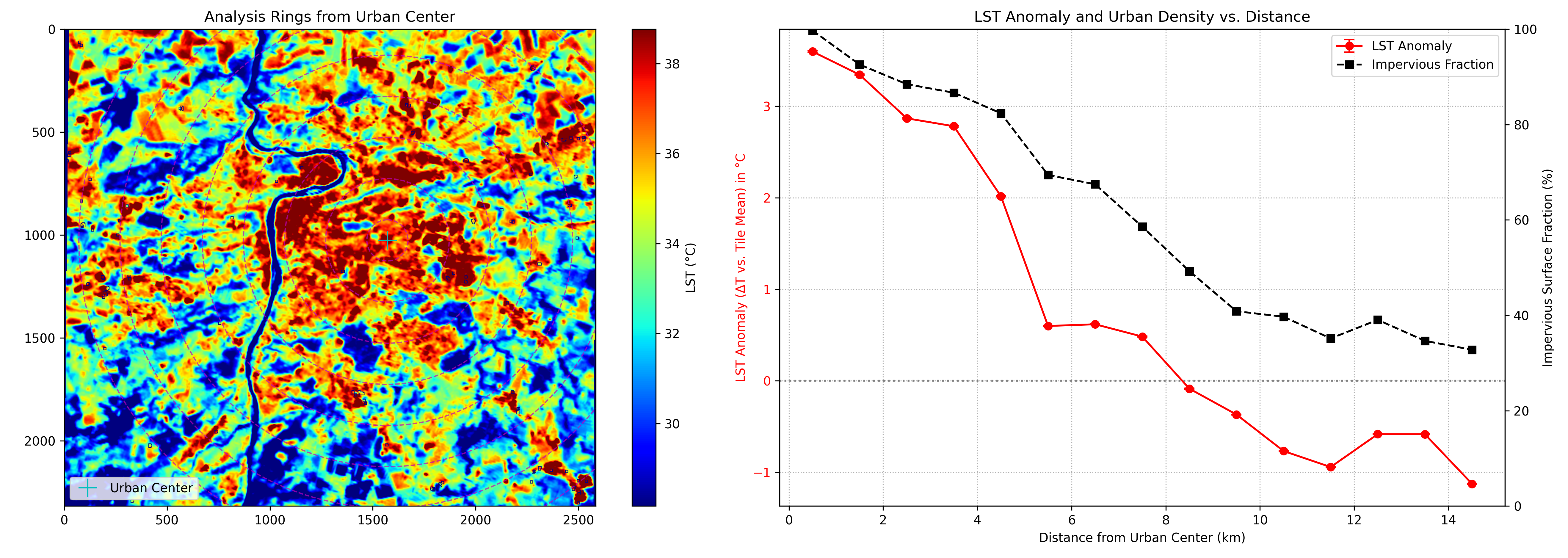
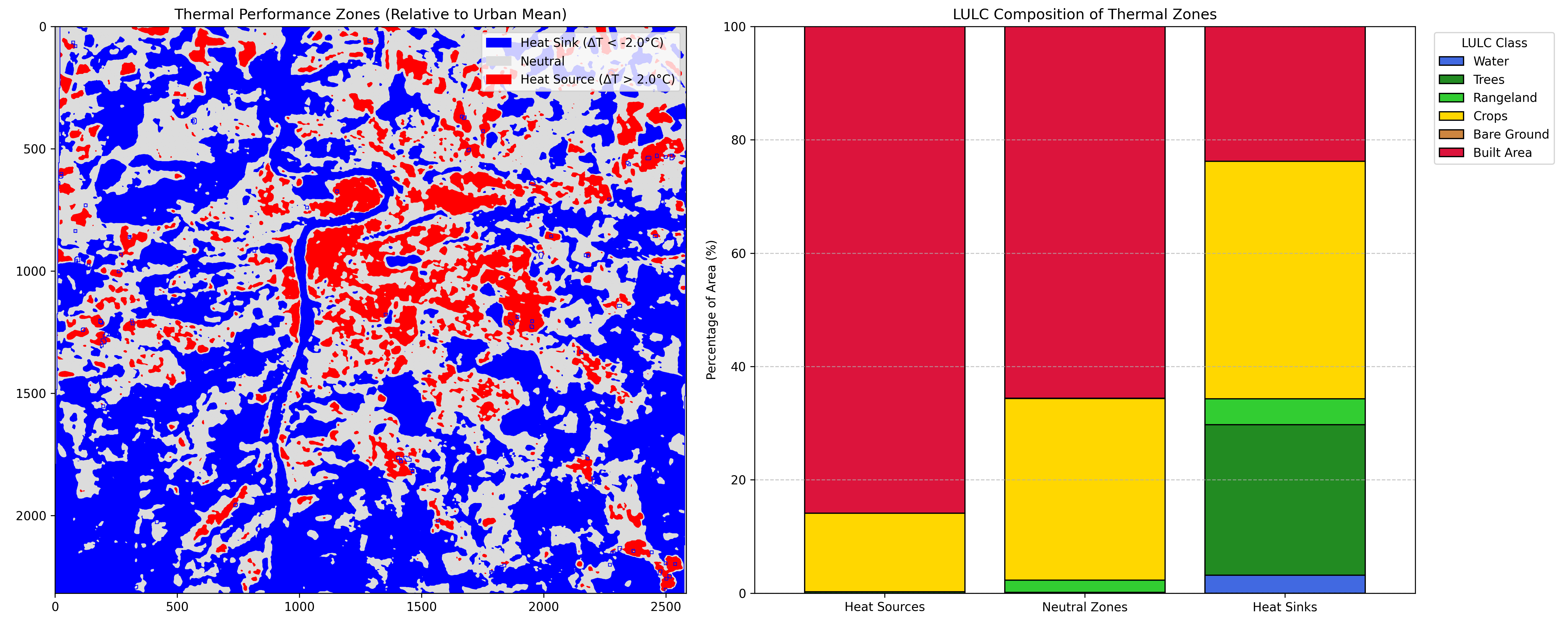
Figure 1: Urban gradient experiment illustrating the spatial distribution of UHI intensity in Prague.
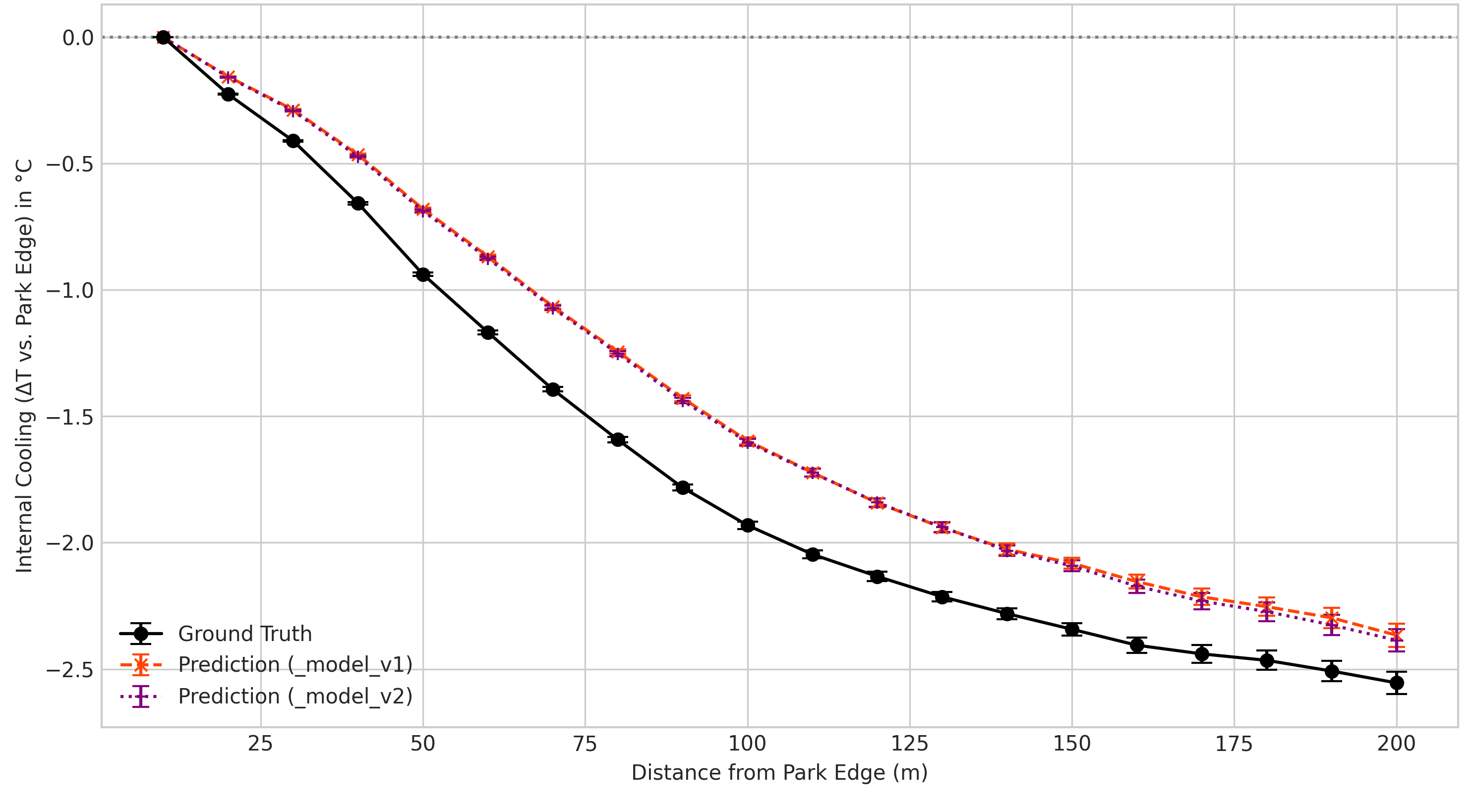
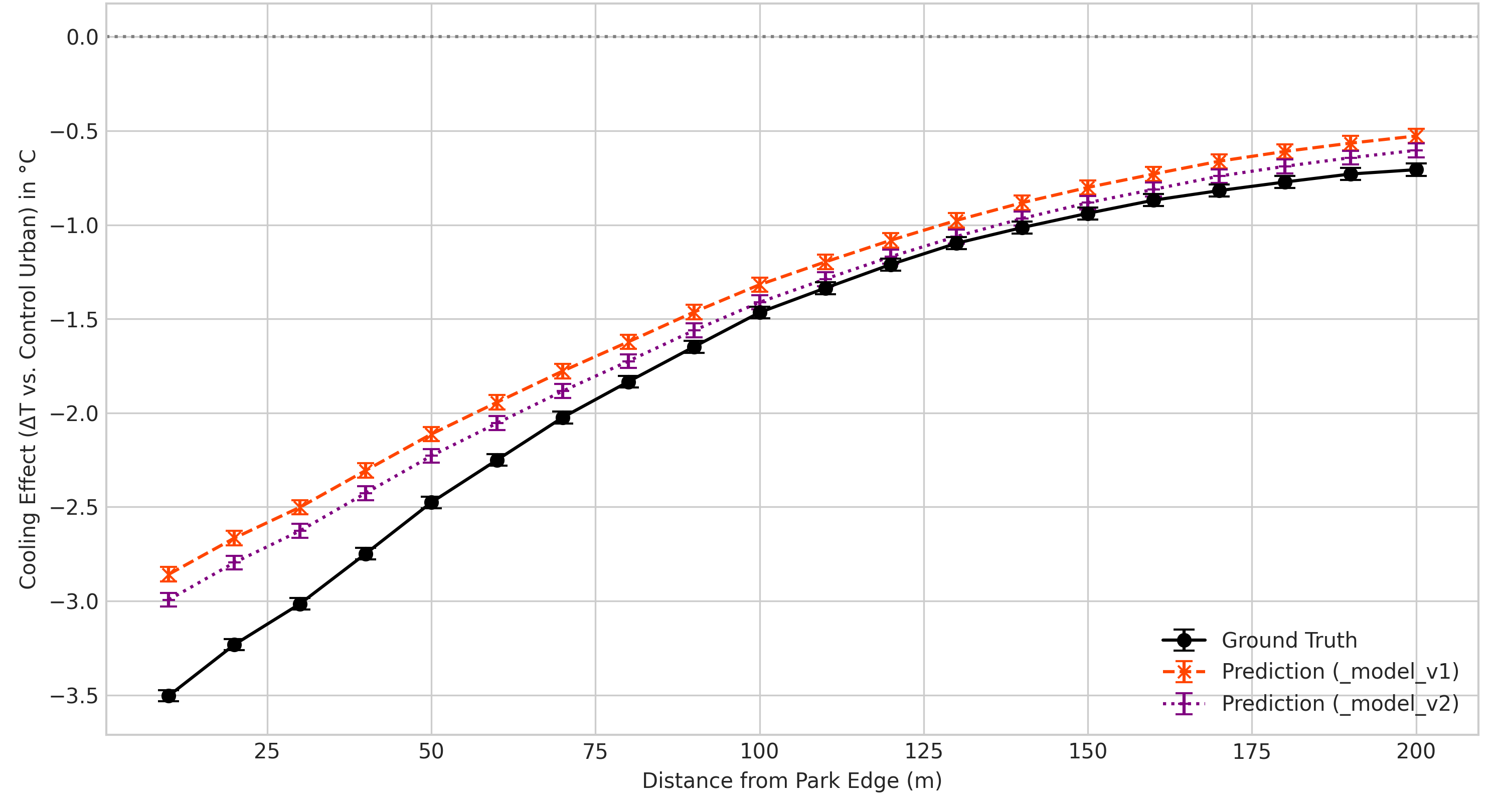
Figure 2: Internal cooling gradient quantifying temperature reduction from park edge to center.
Granite-GFM is evaluated in two configurations: V1 (trained on 28 cities) and V2 (trained on 52 cities). Both models accurately replicate internal cooling gradients, but V2 demonstrates superior performance in modeling spillover effects, with MAE reduced from 0.302∘C (V1) to 0.199∘C (V2). Extrapolation experiments in Brașov show that V2 achieves an MAE of 1.74∘C on the hottest 10% of unseen data, successfully predicting LST up to 3.62∘C beyond the training limit. This quantifies the model's extrapolation capacity for forecasting extreme UHI events.
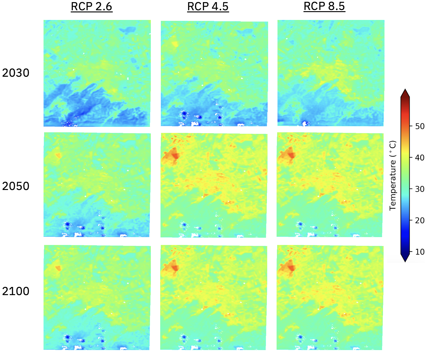
Figure 3: Projected UHI extent under RCP 2.6, 4.5, and 8.5 for 2030, 2050, and 2100 in Brașov.
Simulation of Urban Greening Interventions
The inpainting experiment in Prague demonstrates the model's utility for simulating targeted mitigation strategies. By replacing built-up pixels with green space spectral indices, the model predicts substantial thermal reductions in the intervention area, validated against ground truth data. The simulation quantifies both internal cooling within the new park and spillover effects into the surrounding neighborhood, providing actionable metrics for urban planning.
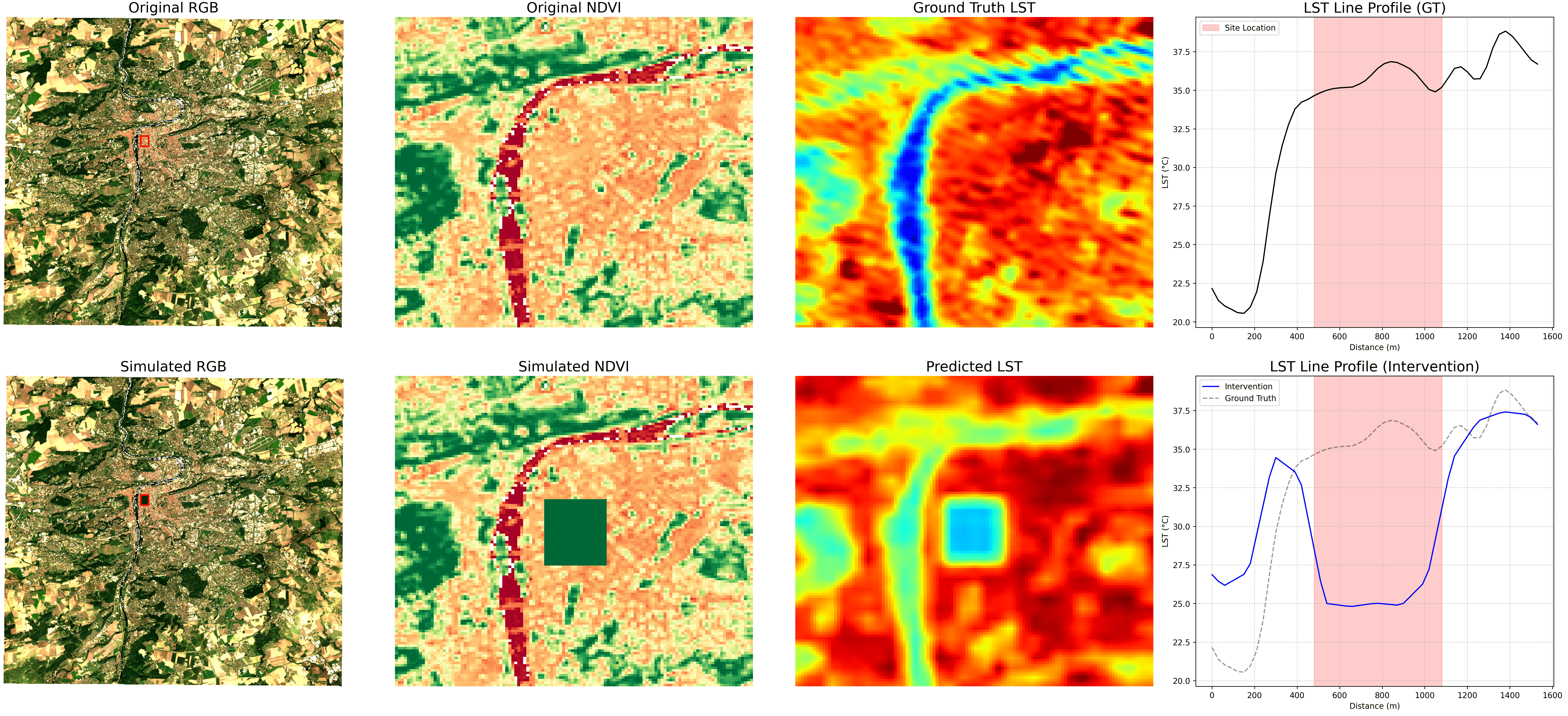
Figure 4: Comparison of inpainting results against ground truth data in Prague, showing thermal impact of simulated greening.
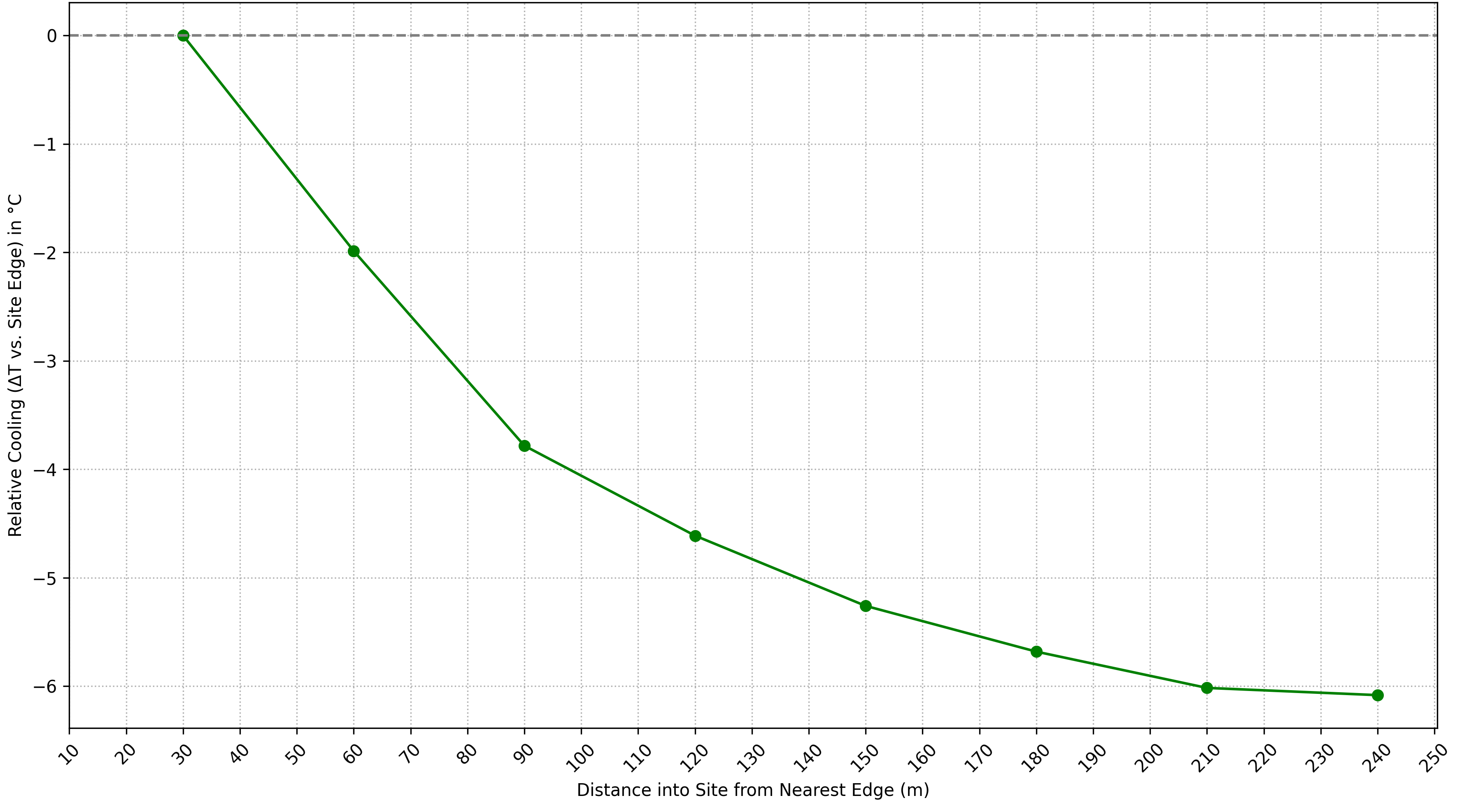

Figure 5: Internal Cooling Gradient for the simulated intervention, confirming the modeled cooling effect.
Generalization Across Diverse Urban Environments
The model's generalization is further validated across twelve European cities with varying hydro-climatic settings, none of which were included in the training data. The workflow demonstrates consistent performance in capturing both internal and spillover cooling phenomena, underscoring the transferability of GFMs for urban climate analysis in data-scarce regions.
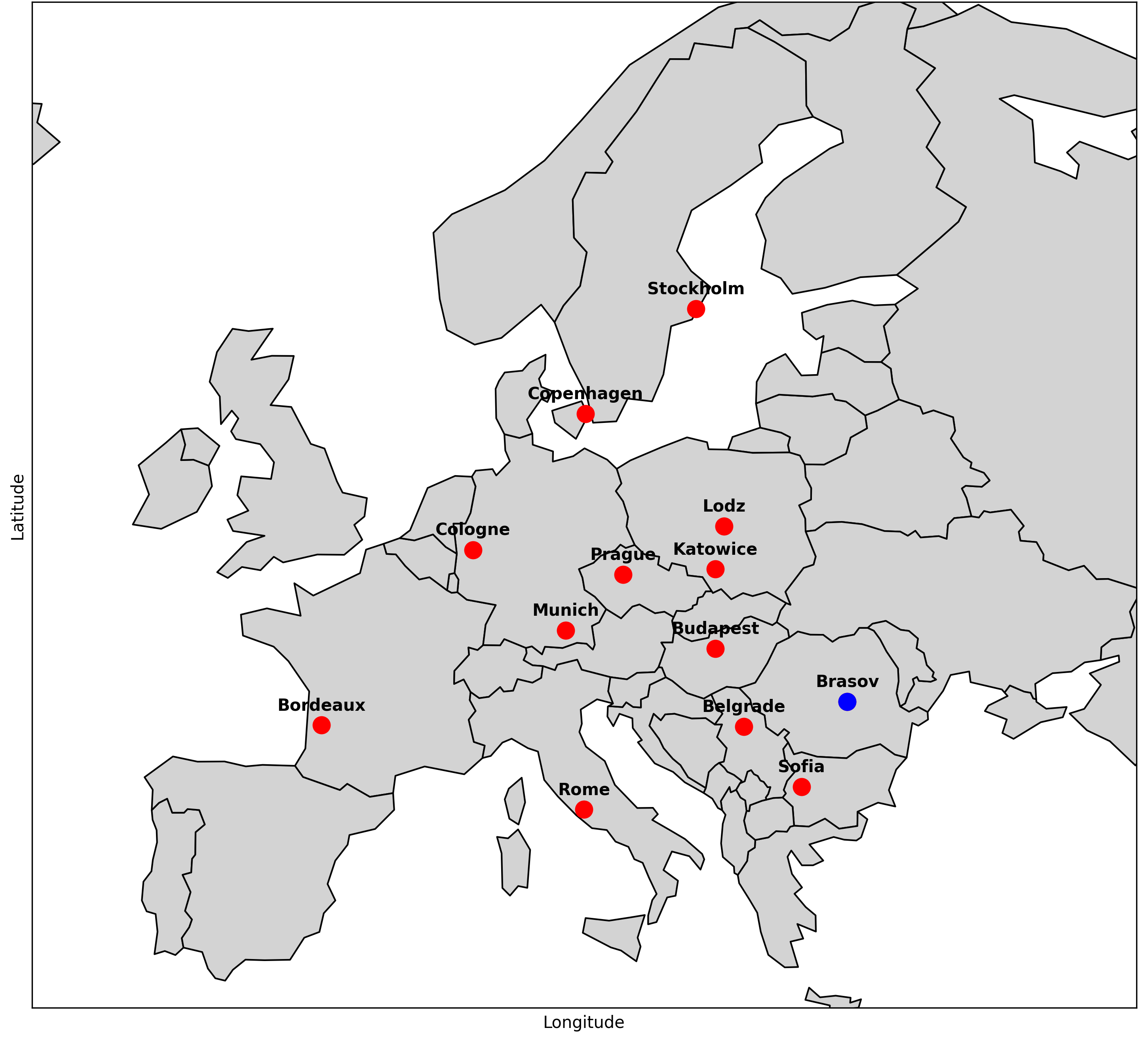
Figure 6: Map of the twelve European study cities (red dots) and Brașov (blue dot) used for model generalization and extrapolation.
Implications and Future Directions
The study establishes that fine-tuned GFMs, specifically those leveraging SWIN Transformer architectures and global Earth observation pre-training, can robustly replicate complex urban thermal phenomena, extrapolate to extreme climate scenarios, and simulate mitigation interventions with high spatial and temporal fidelity. The demonstrated MAE and RMSE metrics indicate that GFMs are suitable for operational deployment in urban climate resilience planning, especially in regions lacking dense sensor networks.
Theoretically, the results suggest that foundation models trained on heterogeneous global data can internalize physical relationships governing urban microclimates, enabling zero-shot and few-shot adaptation to novel domains. Practically, the integration of empirical ground truth, forecasting, and simulation within a unified workflow provides a scalable framework for evidence-based urban planning.
Future research should focus on extending the model to additional climate variables (e.g., humidity, wind speed), integrating multi-modal data sources, and refining extrapolation strategies for even more extreme scenarios. The approach can be generalized to other environmental impact domains, such as air quality and flood risk, leveraging the inherent flexibility of foundation models.
Conclusion
This paper provides a comprehensive evaluation of a fine-tuned geospatial foundation model for UHI detection, forecasting, and mitigation simulation. The empirical, extrapolative, and simulation results collectively demonstrate that GFMs offer a scalable, generalizable, and high-fidelity solution for urban microclimate impact prediction and intervention planning. The workflow transforms GFMs from passive assessment tools into interactive platforms for climate-resilient urban design, with significant implications for both research and policy in urban climate adaptation.