- The paper introduces comprehensive restoration techniques for addressing noise and artifacts in remote sensing images.
- It compares conventional methods and deep learning approaches, highlighting statistical models and optimization techniques.
- Key insights include SAR despeckling and HSI denoising strategies that improve image clarity for advanced analysis.
Introduction to Image Restoration in Remote Sensing
The paper provides a comprehensive overview of image restoration techniques used in remote sensing, which addresses challenges such as noise and artifacts introduced during the acquisition of remote sensing data. Remote sensing technologies, which encompass various imaging systems like RADAR, LiDAR, multispectral, and hyperspectral sensors, are susceptible to degradation from atmospheric effects, sensor noise, and operational conditions. The goal of image restoration is to reconstruct a high-fidelity image from the corrupted data, thereby enhancing its usability for further analyses.
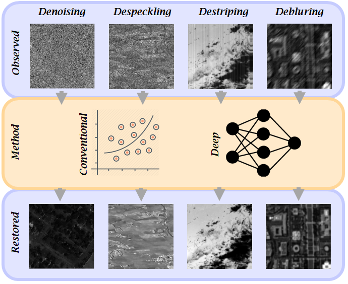
Figure 1: Four remote sensing restoration applications studied in this paper. Denoising, despeckling, destriping, and deblurring are considered as major trends in remote sensing data restoration. The restoration methodology are categorized in two groups i.e., deep learning-based methods and conventional ones.
Synthetic Aperture Radar (SAR) Restoration
SAR imagery restoration is primarily challenged by the speckle phenomenon due to the coherent nature of SAR acquisition. The paper discusses various statistical models crucial for SAR restoration, such as Goodman's model for speckle noise. It explores conventional pixel-based filters and advanced techniques like non-local means and variational methods.
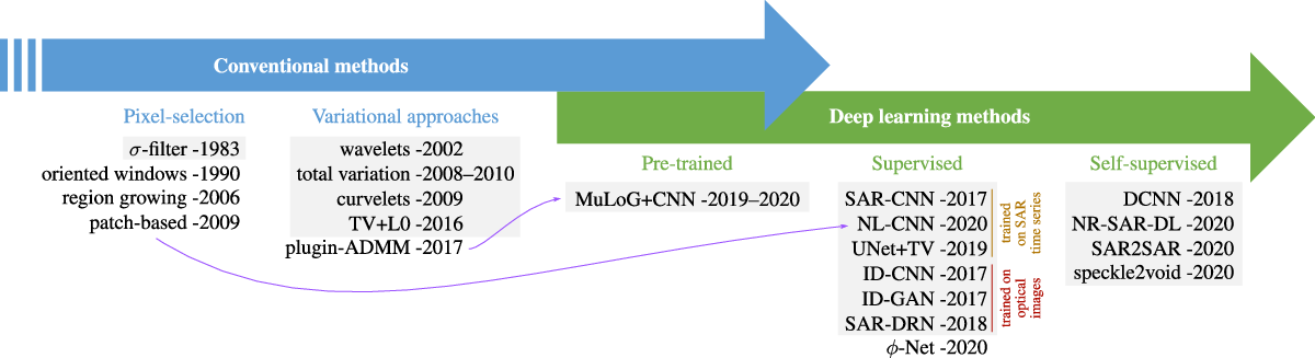
Figure 2: Some representative methods for SAR image restoration, with a special emphasis on deep learning techniques. Methods in gray boxes are designed for SAR intensity images while the other methods can be applied to polarimetric and/or interferometric SAR images.
Deep learning applications to SAR despeckling have recently gained attention, with networks such as SAR-CNN and frameworks like SAR2SAR being prominent. These methods allow for training using real-time series without the availability of clean ground truths, demonstrating improved performance and artifact minimization.
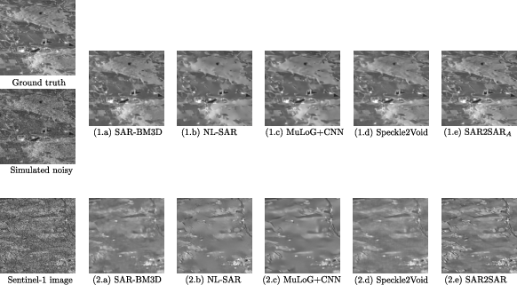
Figure 3: Comparison of several speckle reduction methods for SAR imaging in a numerical simulation (top row) and on an actual single look Sentinel-1 image (bottom row).
Hyperspectral Image (HSI) Denoising
The paper categorizes HSI denoising methods into full-rank approaches, which leverage spatial-spectral correlations, and low-rank methods that take advantage of the spectral redundancy typical in HSIs. Techniques range from traditional wavelet denoising to modern neural-network-based methods like deep image prior techniques. The variability in noise types, such as signal-independent Gaussian noise and mixed noise, is also addressed.
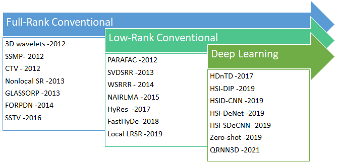
Figure 4: A glance of hyperspectral denoising literature over the past decade.
Destriping in Hyperspectral Images
Destriping is imperative due to systematic noise introduced during the acquisition process, particularly in slit-based hyperspectral systems. The paper elaborates on methodologies from statistical matching to advanced deep learning models like CNNs tailored for stripe noise removal. Categories of stripe noise are explored, with specific attention to the challenges each type presents in the restoration process.
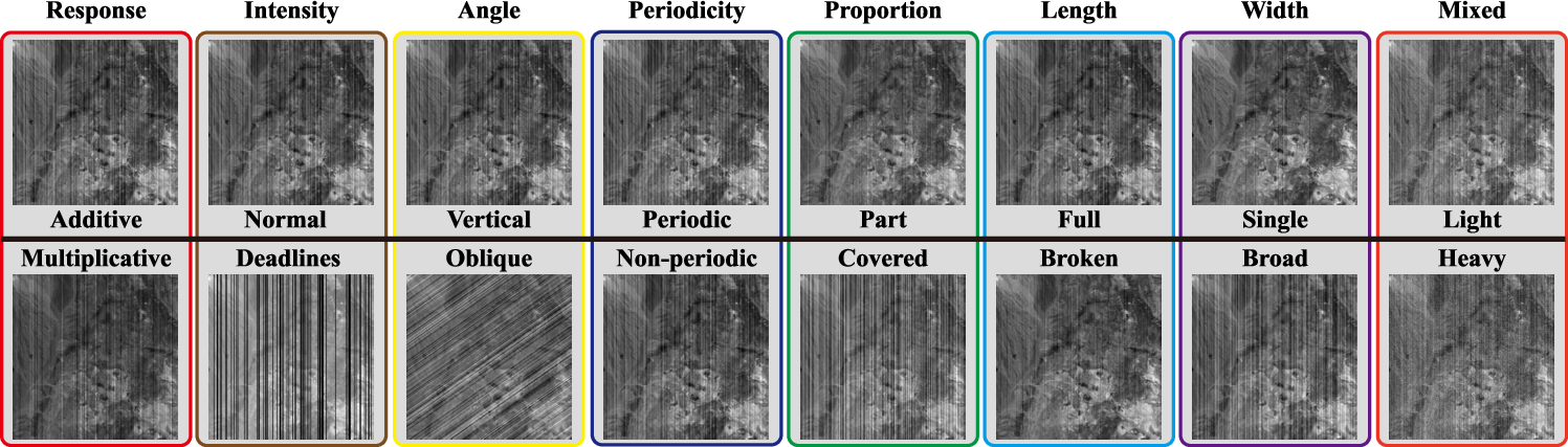
Figure 5: Categories of stripe noise. We classify the stripes into eight categories according to their visual appearances.
Deblurring Techniques for HSIs
Deblurring in HSIs aims to rectify distortions such as atmospheric turbulence and motion blur. The paper discusses optimization models and learning-based techniques, with low-rank tensor recovery methods highlighted for their efficacy in maintaining spectral-spatial coherence.
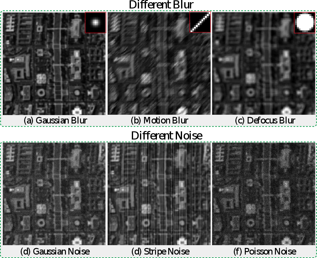
Figure 6: Illustration of different blurs and the co-existing noise. The top row shows three different blurs: Gaussian blur, motion blur, and defocus blur.
Conclusion
This review synthesizes techniques for the restoration of remote sensing images, articulating pivotal methodologies and identifying future research avenues. A significant trend is the transition from traditional analytical methods to data-driven deep learning approaches, unlocking new potentials in handling complex restoration tasks across diverse multispectral and hyperspectral data settings. Challenges remain in terms of model generalization and computational efficiency, especially concerning high-dimensional remote sensing data. As remote sensing technologies and data volumes grow, the development of robust, versatile restoration frameworks will be crucial for extracting reliable and insightful information from degraded remote sensing imagery.