- The paper introduces a convolution-based LatticeKrig model to capture spatially varying covariance, enhancing simulation accuracy of nonstationary processes.
- It aggregates local covariance estimates into a global spatial model, enabling precise emulation of geophysical fields such as surface temperatures.
- The approach leverages parallel computation to scale resource efficiency, making it valuable for large-scale climate model experiments.
Modeling and Emulation of Nonstationary Gaussian Fields
Introduction
The paper "Modeling and Emulation of Nonstationary Gaussian Fields" (1711.08077) focuses on the development of statistical models that capture the nonstationary nature of Gaussian processes, often exhibited in geophysical data. As spatial datasets grow, particularly in climate science, they present heterogenous spatial structures requiring nonstationary modeling to avoid misinterpretations of spatial correlations. This paper introduces a convolution-based model to represent these processes, allowing for spatial variation in both correlation range and variance across the dataset.
Nonstationary Gaussian Processes
The authors propose a methodology using a two-step approach for modeling nonstationary Gaussian processes. Initially, local estimates of covariance functions are obtained by assuming local stationarity. These local models are then aggregated into a global spatial model facilitated by the LatticeKrig (LK) framework.
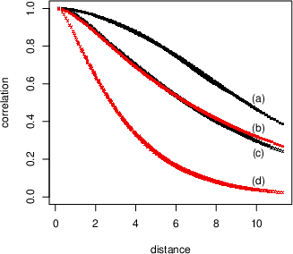
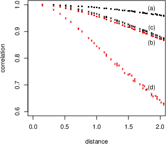
Figure 1: Examples of varying covariance parameters in the LatticeKrig model.
The LK model is adept at handling large datasets and simulating realizations efficiently, even for densely spaced locations. A significant advantage of the LK model is its ability to incorporate local covariance estimates, streamlining the translation to a global model. By leveraging computing resources such as the NCAR supercomputer, the approach allows scaling to thousands of cores, enhancing computational efficiency.
Model Implementation and Effects
The paper demonstrates the practical application of the LK model on geophysical data, specifically surface temperature fields from the NCAR Large Ensemble Project. These fields illustrate significant variability in local response to global mean temperature changes, necessitating a robust model to encapsulate nonstationary characteristics.
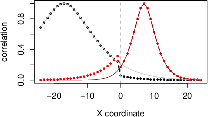
Figure 2: Correlation curves illustrating the non-stationary first test case with superimposed local stationary correlation functions.
Simulation of Nonstationary Processes
Simulation of nonstationary fields is achieved through the LK model, which adapts to the spatial variability of parameters. The authors highlight two test cases exemplifying the efficacy of the LK approximation in capturing the smooth transition of correlation ranges and abrupt discontinuities. This is critical in emulating climatic variables where different spatial domain sections may have disparate statistical properties.
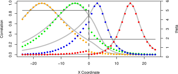
Figure 3: Comparison of LatticeKrig approximation and true non-stationary correlations for a discontinuous parameter test case.
Practical and Theoretical Implications
The research presents significant practical implications for the application of fast statistical emulators in geophysical model simulations. The ability to implement efficient local covariance estimation and simulation in parallel frameworks provides a substantial computational advantage. This approach not only maintains model accuracy but also expedites the emulation process, offering considerable resource savings for climate model experiments.
Conclusion
This study underscores the utility of the LatticeKrig model in efficiently simulating nonstationary Gaussian fields. The model's design facilitates high-level spatial process representation across large datasets, affirming its applicability to extensive geophysical data analysis like climate modeling. As ensemble experiments become more prevalent, tools like the LK model will be pivotal in refined, resource-efficient data emulation.
In closing, the LatticeKrig framework constitutes a robust methodological advance in spatial data modeling, balancing complexity, computational demand, and realism across large and heterogeneous geophysical datasets.
